Contributory members are able to log private notes and comments about each site
Sites ermine has logged. View this log as a table or view the most recent logs from everyone
Kerloas Menhir
Date Added: 22nd Jun 2016
Site Type: Standing Stone (Menhir)
Country: France (Bretagne:Finistère (29))
Visited: Yes on 14th Jul 2004
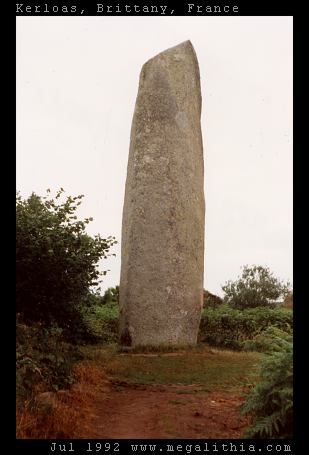
Kerloas menhir submitted by ermine on 14th Jul 2004. This is the tallest standing stone in Europe, according to Aubrey Burl, and would be even taller had it not been hit by lightning 200 years ago. It stands today at 9.5 m above ground.
(View photo, vote or add a comment)
Log Text: None
Kerzerho Alignements
Date Added: 22nd Jun 2016
Site Type: Multiple Stone Rows / Avenue
Country: France (Bretagne:Morbihan (56))
Visited: Yes on 1st Jul 2004
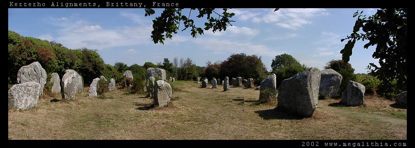
Kerzerho Alignements submitted by ermine on 1st Jul 2004. Kerzerho Alignments
Brittany, Morbihan
47.634690N 3.148402W GPS onsite
You can still walk among the stones at Kerzerho (in 2002 at east) which are near Carnac but not quite so busy. Head up the D781 to Erdeven. You can park nearby, and from there you can also take the path to the large stones of the Table du Sacrifice
(View photo, vote or add a comment)
Log Text: None
Mané Keriaval
Date Added: 22nd Jun 2016
Site Type: Passage Grave
Country: France (Bretagne:Morbihan (56))
Visited: Yes on 30th Jun 2004
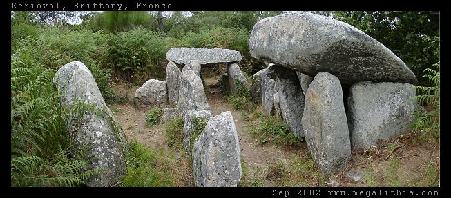
Mané Keriaval submitted by ermine on 30th Jun 2004. Morbihan, Carnac area
47.61535N 3.083378W WGS84 GPS onsite
You'd be forgiven for thinking this is a dolmen, and it is locally listed as such, but Burl sets you right. These stones were originally a passage grave with an earth mound on top
(View photo, vote or add a comment)
Log Text: None
Martlesham Heath
Date Added: 22nd Jun 2016
Site Type: Round Barrow(s)
Country: England (Suffolk)
Visited: Yes on 29th Jun 2004

Martlesham Heath submitted by ermine on 29th Jun 2004. Grid Reference: TM256454
Type of site: Round Barrow
County : Suffolk
Nearest Town: Ipswich
Nearest Village: Martlesham Heath
Any web links relating to it: <a target=_top href="http://www.megalithia.com/sites/tm256454.html">Megalithia</a>
Barrow hidden in the woods on the left-hand side of the footpath leading from the industrial estate past the trailer park, as you come out of the woods and see the BT Earth station dishes to your right. A possible smaller site is ab...
(View photo, vote or add a comment)
Log Text: None
Grandson Menhir
Date Added: 22nd Jun 2016
Site Type: Standing Stone (Menhir)
Country: Switzerland (Waadt)
Visited: Yes on 27th Jun 2004
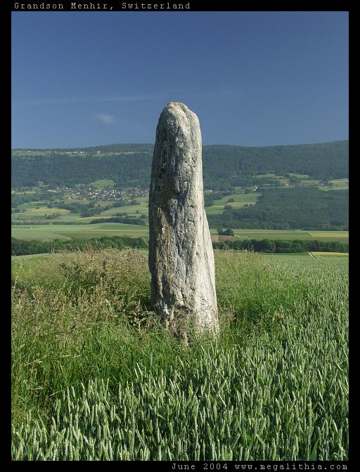
Grandson Menhir submitted by ermine on 27th Jun 2004. Grandson Menhir
See megalith map entry
(View photo, vote or add a comment)
Log Text: None
Kerran Dolmens
Date Added: 22nd Jun 2016
Site Type: Chambered Tomb
Country: France (Bretagne:Morbihan (56))
Visited: Yes on 27th Jun 2004

Kerran dolmens submitted by ermine on 27th Jun 2004. Kerran
47.598N 2.988W
This is one of two dolmens near the intersection of the D28 with the D781 (the other is more dilapidated)
(View photo, vote or add a comment)
Log Text: None
Pierres Plates (Locmariaquer)
Date Added: 22nd Jun 2016
Site Type: Burial Chamber or Dolmen
Country: France (Bretagne:Morbihan (56))
Visited: Yes on 27th Jun 2004
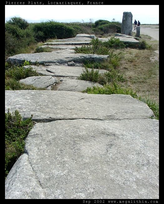
Pierres Plates (Locmariaquer) submitted by ermine on 27th Jun 2004. Les Pierres Plates
(View photo, vote or add a comment)
Log Text: None
La Table des Marchands
Date Added: 22nd Jun 2016
Site Type: Burial Chamber or Dolmen
Country: France (Bretagne:Morbihan (56))
Visited: Yes on 27th Jun 2004

La Table des Marchands submitted by ermine on 27th Jun 2004. Table des Marchands - carving in capstone
(View photo, vote or add a comment)
Log Text: None
Luffang Allée Couverte
Date Added: 22nd Jun 2016
Site Type: Passage Grave
Country: France (Bretagne:Morbihan (56))
Visited: Yes on 27th Jun 2004

Luffang Allée Couverte submitted by ermine on 27th Jun 2004. 47.61309N 3.024552W
This passage-grave contained unique artwork on the end stone, now preserved in Carnac museum. Signposted at the site as Allee Couverte
(View photo, vote or add a comment)
Log Text: None
Grand Menhir Brisé
Date Added: 22nd Jun 2016
Site Type: Standing Stone (Menhir)
Country: France (Bretagne:Morbihan (56))
Visited: Yes on 27th Jun 2004
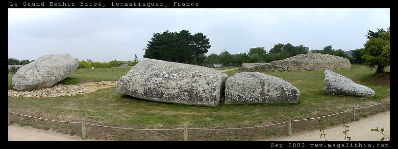
Grand Menhir Brisé submitted by ermine on 27th Jun 2004. Grand Menhir Brisé, Locmariaquer.
A megalithic tragedy.
(View photo, vote or add a comment)
Log Text: None
Degernau Menhir
Date Added: 22nd Jun 2016
Site Type: Standing Stone (Menhir)
Country: Germany (Baden-Wuerttemberg)
Visited: Yes on 27th Jun 2004
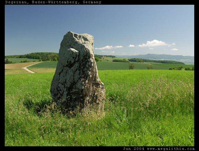
Degernau Menhir submitted by ermine on 27th Jun 2004. Menhir of Degernau, Baden-Württemberg, Germany
47.66380N 8.401683E
lovely setting on the crest of a rise with a commanding view
(View photo, vote or add a comment)
Log Text: None
Clendy Steinalleen
Date Added: 22nd Jun 2016
Site Type: Stone Row / Alignment
Country: Switzerland (Waadt)
Visited: Yes on 23rd Jun 2004
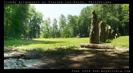
Clendy Steinalleen submitted by ermine on 23rd Jun 2004. Alignment of standing stones at the southern end of Lac Neuchatel, Switzerland near Yverdon-Les_Bains. Two lines of standing stones intersect, roughly at the camera POV. As well as the straight lines, there is a semicircle of stones. For more details see http://www.megalithia.com/sites/4678n0666e.html
(View photo, vote or add a comment)
Log Text: None
Kerlescan Alignements
Date Added: 22nd Jun 2016
Site Type: Multiple Stone Rows / Avenue
Country: France (Bretagne:Morbihan (56))
Visited: Yes on 10th Sep 2002

Kerlescan alignements submitted by ermine on 10th Sep 2002. View of the Kerlescan alignments at Carnac.
The alignments are formed of rows of standing stones running for several hundred yards approximately E/W Panorama is taken from the NW
(View photo, vote or add a comment)
Log Text: None
Ménec alignements
Date Added: 22nd Jun 2016
Site Type: Multiple Stone Rows / Avenue
Country: France (Bretagne:Morbihan (56))
Visited: Yes on 10th Sep 2002

Ménec alignements submitted by ermine on 10th Sep 2002. View of the Carnac Alignments from Le Menec village at the western end. The alignments consist of up to twelve rows of menhirs extending for almost a kilometre
(View photo, vote or add a comment)
Log Text: None
Stoke Flat
Date Added: 13th Feb 2022
Site Type: Stone Circle
Country: England (Derbyshire)
Visited: Would like to visit
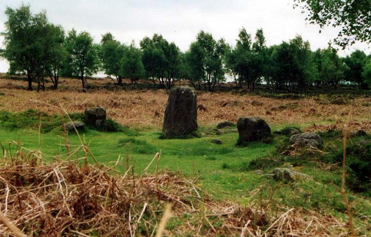
Stoke Flat submitted by PaulM on 1st Sep 2001. Froggatt Edge stone circle (aka Stoke Flat), Derbyshire GR: SK249768
Froggatt Edge stone circle is set on a flat shelf, overlooking the picturesque Derwent Valley.
Often referred to as Stoke Flat, the site is complex, though now sadly quite ruined. It consists of an embanked stone circle with two entrances exactly opposite, to the north-north-west and south-south-east. Traces of dry-stone walling in the northern entrance suggest that it may have been deliberately blocked at some time in p...
(View photo, vote or add a comment)
Wook's Quoit
Date Added: 26th Jan 2018
Site Type: Standing Stone (Menhir)
Country: England (Somerset)
Visited: Would like to visit
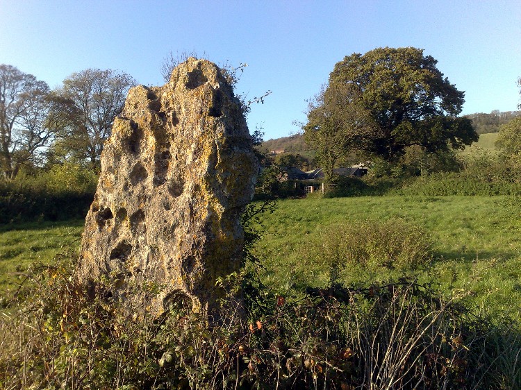
Wook's Quoit submitted by soulsurfer on 4th Nov 2009. Wooks Quoit. Yarberry farm. October 2008
(View photo, vote or add a comment)
Rolstone
Date Added: 26th Jan 2018
Site Type: Standing Stone (Menhir)
Country: England (Somerset)
Visited: Would like to visit
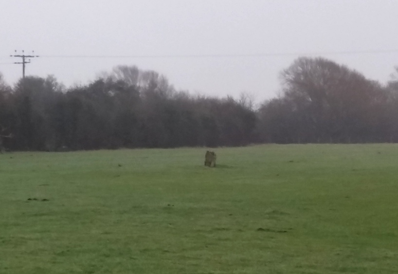
Rolstone submitted by TheCaptain on 20th Jan 2018. Near Cannaway's Farm, this stone stands in the middle of a field.
Apologies for awful picture. It was a miserable wet and misty day, and the batteries on my camera had died, so this was taken from the fieldgate on my phone.
(View photo, vote or add a comment)
Batcombe Hollow north stone
Date Added: 26th Jan 2018
Site Type: Standing Stone (Menhir)
Country: England (Somerset)
Visited: Would like to visit
Batcombe Hollow north stone submitted by dawntreader on 7th Oct 2012. Standing stone at the north end of Batcombe Hollow with dew pond in the background.
(View photo, vote or add a comment)
The Bridestones (Staindale)
Date Added: 22nd Jun 2016
Site Type: Natural Stone / Erratic / Other Natural Feature
Country: England (Yorkshire (North))
Visited: Would like to visit
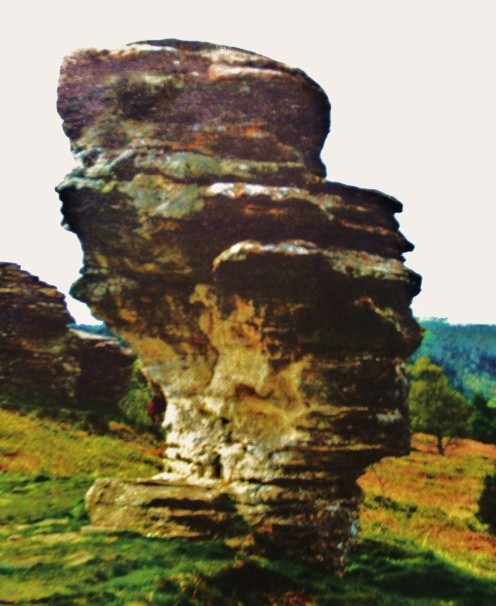
The Bridestones (Staindale) submitted by Sunny100 on 20th Sep 2010. Probably one of the best known of the sandstone rock formations known as The Bridestones at Staindale, North York Moors, is the salt-seller or pepperpot standing at 30 feet tall on its slender stone pedestal. Erosion over thousands of years has caused these curious shapes to occur.
(View photo, vote or add a comment)
Blue Man-i'-th'-Moss Standing Stone.
Date Added: 22nd Jun 2016
Site Type: Standing Stone (Menhir)
Country: England (Yorkshire (North))
Visited: Would like to visit

Blue Man-i'-th'-Moss Standing Stone. submitted by Bladup on 28th Jan 2014. Blue Man-i''-th''-Moss Standing Stone.
(View photo, vote or add a comment)
