Contributory members are able to log private notes and comments about each site
Sites TimPrevett has logged. View this log as a table or view the most recent logs from everyone
Duddo Five Stones
Date Added: 18th Sep 2010
Site Type: Stone Circle
Country: England (Northumberland)
Visited: Yes on 18th May 2010
Duddo Five Stones submitted by TimPrevett on 18th May 2010. Follow the sign... 11/04/10
(View photo, vote or add a comment)
Log Text: None
Durrington Walls
Date Added: 18th Sep 2010
Site Type: Henge
Country: England (Wiltshire)
Visited: Yes on 10th Oct 2006

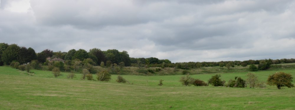
Durrington Walls submitted by TimPrevett on 10th Oct 2006. A composite image of half of Durrington Walls (the western side); compare scale of house to the left with the ring left in the landscape.
(View photo, vote or add a comment)
Log Text: None
Dyffryn Ardudwy
Date Added: 18th Sep 2010
Site Type: Portal Tomb
Country: Wales (Gwynedd)
Visited: Yes on 2nd Oct 2005

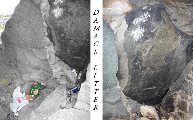
Dyffryn Ardudwy submitted by TimPrevett on 2nd Oct 2005. Dyffryn Ardudwy is a very easily accessible site, which brings with it a problem. The larger, later dolmen is used as a den. A hearth was built against one of the uprights, now heavily sooted. The chamber was littered with drink cans, and the surrounding cairn has broken drinks bottles and glass in many places. We took away a carrier bag overflowing with unwanted material.
(View photo, vote or add a comment)
Log Text: None
Dyffryn Lane, Berriew
Date Added: 18th Sep 2010
Site Type: Henge
Country: Wales (Powys)
Visited: Yes on 22nd Mar 2006

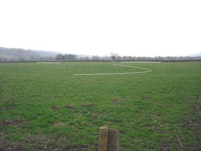
Dyffryn Lane, Berriew submitted by TimPrevett on 22nd Mar 2006. If one looks carefully at the Dyffryn Lane henge site, especially with reference to the aerial image in the CADW guide to Clywd & Powys, three areas of corresponding contours can be detected. Look for curves and rises juxtaposed against the linear hedgerows. I have marked the picture here to help show off the distant curves near the field boundary, and a closer mark to show the contours nearer the front of the image. Walking down from Maen Beuno, just a couple minutes, look over the field opposi...
(View photo, vote or add a comment)
Log Text: None
Earls Hill Camp
Date Added: 18th Sep 2010
Site Type: Hillfort
Country: England (Shropshire)
Visited: Yes on 29th Jun 2004
Earls Hill Camp submitted by TimPrevett on 29th Jun 2004. Find a hill in Shropshire, and it likely has a hillfort upon it! In this picture are two hillforts - Earl's Hill Camp (a rampart can be seen upon the right hand side of the top hill), and Pontesford Hill hillfort, covered by trees now. Taken on the move on the A488 looking south.
(View photo, vote or add a comment)
Log Text: None
East Pinford (NW)
Date Added: 18th Sep 2010
Site Type: Multiple Stone Rows / Avenue
Country: England (Somerset)
Visited: Yes on 7th Jul 2002

East Pinford (NW) submitted by TimPrevett on 7th Jul 2002. East Pinford Multiple Stone Rows
SS797427
The nearest to a stone avenue that I have seen on Exmoor; two straight rows of three quite large stones in each, other small stones dotted around.
Photo, visit & text by Roger Gay, South Molton, Devon. Scanning & editing by Tim Prevett.
(View photo, vote or add a comment)
Log Text: None
Eathorne Menhir
Date Added: 18th Sep 2010
Site Type: Standing Stone (Menhir)
Country: England (Cornwall)
Visited: Yes on 8th May 2003

Eathorne Menhir submitted by TimPrevett on 8th May 2003. This gives a better view of the abuse this stone has suffered.
(View photo, vote or add a comment)
Log Text: None
Eggardon Hill
Date Added: 18th Sep 2010
Site Type: Hillfort
Country: England (Dorset)
Visited: Yes on 18th Aug 2004
Eggardon Hill submitted by TimPrevett on 18th Aug 2004. Cutting across the south east entrance to the hillfort, which enters the picture at the bottom right.
(View photo, vote or add a comment)
Log Text: None
Eglwyseg Cairn Circle
Date Added: 18th Sep 2010
Site Type: Cairn
Country: Wales (Denbighshire)
Visited: Yes on 4th Feb 2006
Eglwyseg Cairn Circle submitted by TimPrevett on 4th Feb 2006. A large cairn circle; see main entry for details.
(View photo, vote or add a comment)
Log Text: None
Eglwyseg Kerb Cairn A
Date Added: 18th Sep 2010
Site Type: Cairn
Country: Wales (Denbighshire)
Visited: Yes on 4th Feb 2006

Eglwyseg Kerb Cairn A submitted by TimPrevett on 4th Feb 2006. The first of two small kerb cairns very close together; about 12 feet diameter, looking east.
(View photo, vote or add a comment)
Log Text: None
Eglwyseg Kerb Cairn B
Date Added: 18th Sep 2010
Site Type: Cairn
Country: Wales (Denbighshire)
Visited: Yes on 4th Feb 2006

Eglwyseg Kerb Cairn B submitted by TimPrevett on 4th Feb 2006. Not as defined as its neighbour, the Kerb Cairn B is still obvious. Have taken it with the tree in for point of reference, but the trees up there were largely dead, or on their way - so this may not be there for much longer.
(View photo, vote or add a comment)
Log Text: None
Eglwyseg Mountain
Date Added: 18th Sep 2010
Site Type: Standing Stone (Menhir)
Country: Wales (Denbighshire)
Visited: Yes on 4th Feb 2006

Eglwyseg Mountain submitted by TimPrevett on 4th Feb 2006. Megaraks in the mist... the visibility up here varied from second to second, literally. I went to explore the panel on a large stone, turned around and my companion was disappearing, along with the standing stone. See main entry for details.
(View photo, vote or add a comment)
Log Text: None
Eglwyseg Plantation Barrow
Date Added: 18th Sep 2010
Site Type: Round Barrow(s)
Country: Wales (Denbighshire)
Visited: Yes on 4th Feb 2006

Eglwyseg Plantation Barrow submitted by TimPrevett on 4th Feb 2006. The greener mound in the foreground is the barrow, set back from one of the ridges of the Egwlysegs; to the rear horizon can be seen the Creigiau Eglwyseg barrow. Some natural limestone protrudes from this barrow, just visible on the other (west) side.
(View photo, vote or add a comment)
Log Text: None
Eglwyseg Plantation Cairn 1
Date Added: 18th Sep 2010
Site Type: Cairn
Country: Wales (Denbighshire)
Visited: Yes on 3rd Feb 2006

Eglwyseg Plantation Cairn 1 submitted by TimPrevett on 3rd Feb 2006. A large robbed cairn, some 11 metres in diameter; smaller stones on the east side, larger on the west.
(View photo, vote or add a comment)
Log Text: None
Eglwyseg Stone
Date Added: 18th Sep 2010
Site Type: Natural Stone / Erratic / Other Natural Feature
Country: Wales (Denbighshire)
Visited: Yes on 4th Feb 2006

Eglwyseg Stone submitted by TimPrevett on 4th Feb 2006. The Eglwyseg Stone - a probable glacial erratic, in the foreground, with a mound which is thought to be possibly be prehistoric.
(View photo, vote or add a comment)
Log Text: None
Elder Bush Cave
Date Added: 18th Sep 2010
Site Type: Cave or Rock Shelter
Country: England (Staffordshire)
Visited: Yes on 29th Jul 2006
Elder Bush Cave submitted by TimPrevett on 29th Jul 2006. A view of the entrance with the crags to the east above Sevenways and Thor's caves showing. Elder Bush Cave had animal remains from Pleistocene period (exactly when is not given - not that helpful considering the length of the Pleistocene), with Upper Paleolithic, Mesolithic, Neolithic, Bronze & Iron Ages, and Roman human activity all noted. Humans have been using these shelters for a long time, and animals even longer. On my visit, I did not enter the cave, as it was being used by a nest of bee...
(View photo, vote or add a comment)
Log Text: None
Ellerdine Heath
Date Added: 18th Sep 2010
Site Type: Standing Stone (Menhir)
Country: England (Shropshire)
Visited: Yes on 9th Oct 2005

Ellerdine Heath submitted by TimPrevett on 9th Oct 2005. This stone, maybe post mediaeval but not certain, is documented in a photograph between 1931 and 1934, with its last entry on the SMR in Septmeber 1975. A visit on 9th October 2005 yielded nothing. A thorough search of the field and boundaries, to the left of the road behind this signpost (used this photo as point of reference for anyone else checking), was unsuccessful.
(View photo, vote or add a comment)
Log Text: None
Engine Vein, Alderley Edge Copper Mines
Date Added: 18th Sep 2010
Site Type: Ancient Mine, Quarry or other Industry
Country: England (Cheshire)
Visited: Yes on 26th Aug 2007

Engine Vein, Alderley Edge Copper Mines submitted by TimPrevett on 26th Aug 2007. Looking east through the Engine Vein, which has been mined for 4,000 years. See main article for details.
(View photo, vote or add a comment)
Log Text: None
Eweleaze Barn
Date Added: 18th Sep 2010
Site Type: Barrow Cemetery
Country: England (Dorset)
Visited: Yes on 24th May 2005
Eweleaze Barn submitted by TimPrevett on 24th May 2005. The barrows across the ridge to Eweleaze Barn show up very nicely as green in front of the rapeseed fields.
(View photo, vote or add a comment)
Log Text: None
Eyam Moor II
Date Added: 14th Jan 2025
Site Type: Stone Circle
Country: England (Derbyshire)
Visited: Yes on 14th Jan 2025. My rating: Condition 2 Ambience 3 Access 3

Eyam Moor 2 submitted by PaulM on 31st Aug 2001. General view of Eyam Moor II stone circle. GR:SK231789. Mentioned on several occasions by antiquarians, Eyam Moor II stone circle was only rediscovered in 1983, which is rather surprising considering its close proximity to the well used footpath.This embanked stone circle is now somewhat ruined and submerged. One of the smallest sites of Derbyshire, it is approximately 8m by 7.5m in diameter with only four low stones, ranging in height between 0.15m and 0.3m, set into the bank. The circle is co...
(View photo, vote or add a comment)
Log Text: Visited after 25 years at least today; one that takes a bit of a hunt. The embankment still visible and prominent if you can interpret it in the growth of Heather, fern and bilberry. The grid ref from the OS app stood inside the circle was SK 23163 78964.
