Contributory members are able to log private notes and comments about each site
Sites TheCaptain has logged. View this log as a table or view the most recent logs from everyone
La Roque-Saint-Christophe
Date Added: 21st Oct 2020
Site Type: Ancient Village or Settlement
Country: France (Aquitaine:Dordogne (24))
Visited: Yes on 19th Sep 1978
La Roque-Saint-Christophe submitted by theCaptain on 6th Jan 2011. In a gigantic cliff face beside the river Vézère is found this World Heritage Site.
It's an entire troglodytic city which was inhabited continuously from 50000 years ago until a few centuries ago.
(View photo, vote or add a comment)
Log Text: Hitch Hiking Trip round France in the summer of 1978. Camped for a couple of days at Les Eyzies to visit and wonder at the ancient sites here.
Font-de-Gaume
Date Added: 21st Oct 2020
Site Type: Cave or Rock Shelter
Country: France (Aquitaine:Dordogne (24))
Visited: Yes on 18th Sep 1978
Font-de-Gaume submitted by ocdolmen on 26th May 2006. Site in Aquitaine: Dordogne (24)
Entrance of Font de Gaume cave, Dordogne, France.
The entrance is on the right on the photo (the cave on the left is a dead end and presents no drawing)
Inside the cave, a great number of buffalos and horses drawings and some engraved drawings.
Magdalenian period (about 20.000 BCE)
One of the rare prehistoric cave with drawings still open to public.
(View photo, vote or add a comment)
Log Text: Hitch Hiking Trip round France in the summer of 1978. Camped for a couple of days at Les Eyzies to visit and wonder at the ancient sites here.
Musée National de Préhistoire
Date Added: 21st Oct 2020
Site Type: Museum
Country: France (Aquitaine:Dordogne (24))
Visited: Yes on 18th Sep 1978
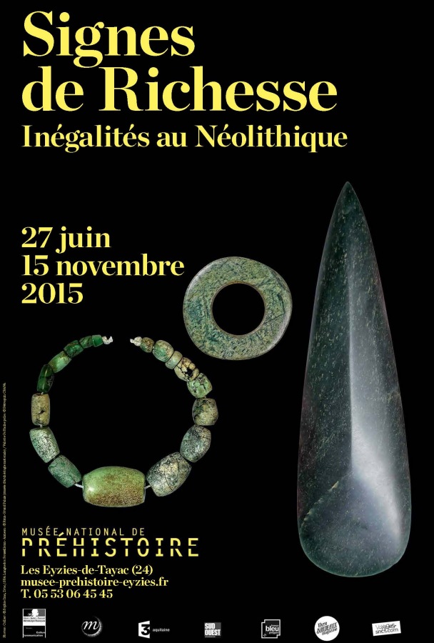
Musée National de Préhistoire submitted by dodomad on 5th Jul 2015. Exhibition: Signs of wealth. Inequalities in the Neolithic, running from 27th June 2015 to 15th November 2015
More details on our site page, in the comments section (click left)
(View photo, vote or add a comment)
Log Text: Hitch Hiking Trip round France in the summer of 1978. Camped for a couple of days at Les Eyzies to visit and wonder at the ancient sites here.
Abri de Cro-Magnon
Date Added: 21st Oct 2020
Site Type: Cave or Rock Shelter
Country: France (Aquitaine:Dordogne (24))
Visited: Yes on 17th Sep 1978
Abri de Cro-Magnon submitted by thecaptain on 2nd Sep 2006. Abri de Cro-Magnon UNESCO World Heritage site.
It's nothing much to see, just a little rock shelter in the cliff face shaded by a couple of large chestnut trees, with a little walled and fenced area around it.
It is sadly hidden round the back of the hotel and almost forgotten.
(View photo, vote or add a comment)
Log Text: Hitch Hiking Trip round France in the summer of 1978. Camped for a couple of days at Les Eyzies to visit and wonder at the ancient sites here.
Menhir Ste Carissime
Trip No.205 Entry No.40 Date Added: 19th Oct 2020
Site Type: Standing Stone (Menhir)
Country: France (Midi:Tarn (81))
Visited: Yes on 2nd Sep 2005. My rating: Condition 4 Ambience 4 Access 3

Menhir Ste Carissime submitted by thecaptain on 26th Jan 2006. Along the D.1 road between Le Verdier and Cahuzac-sur-Vère, and this menhir can be seen across the far side of the river, nicely positioned at a bend in the river below vine covered hillsides.
(View photo, vote or add a comment)
Log Text: Along the D.1 road between Le Verdier and Cahuzac-sur-Vère, and this menhir can be seen across the far side of the river, which is beyond a ploughed field to the south. At this time in the evening, the menhir was glowing a golden colour in the rays of the setting sun. I struggled across the ploughed field to get a close look from across the river, and estimate it to be about 2 metres tall and 1 metre wide, nicely positioned at a bend in the river below vine covered hillsides. After returning to my van and driving off, about half a mile further east along the road I saw a sign to "menhir" which would have taken you along a footpath and across a bridge to approach the menhir. Oh well.
Dolmen de Saillac
Trip No.205 Entry No.37 Date Added: 19th Oct 2020
Site Type: Burial Chamber or Dolmen
Country: France (Midi:Tarn-et-Garonne (82))
Visited: Yes on 2nd Sep 2005. My rating: Condition 2 Ambience 4 Access 4
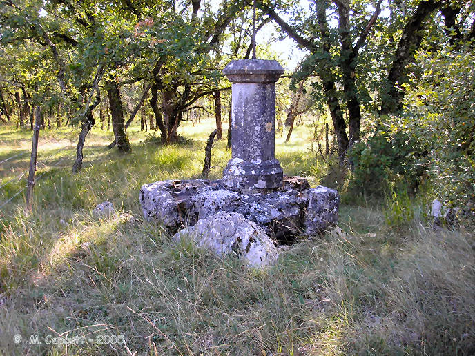
Dolmen de Saillac submitted by thecaptain on 23rd Jan 2006. This is a bizarrely Christianised dolmen which can be found in the forests to the south of the village of Caylus in Tarn-et-Garonne.
The dolmen is still partially contained within its circular mound, and the remains of two sidestones and a backstone can be seen, with the small capstone balanced on these and a few other bits of stone to make it level.
(View photo, vote or add a comment)
Log Text: This is a bizarrely Christianised dolmen which can be found in the forests to the south of the village of Caylus. From Caylus follow the signs to St-Amans-le-Vieux ancient church, and park in the vicinity of this, from where you take the GR46 Footpath the opposite way from the road towards the southwest for about 500 metres, and the remains of the dolmen can be seen on the left.
This dolmen has been much altered, and at first I had difficulty recognising it, but it is right beside the path with the wall built right through it. On top of the remains of the capstone has been built a stone plinth, with an ornate iron cross protruding from this, the top of which is about 3 metres above the ground. The dolmen is still partially contained within its circular mound, and the remains of two sidestones and a backstone can be seen, with the small capstone balanced on these and a few other bits of stone to make it level.
Dolmen du Pech (Cazals)
Trip No.205 Entry No.36 Date Added: 19th Oct 2020
Site Type: Burial Chamber or Dolmen
Country: France (Midi:Tarn-et-Garonne (82))
Visited: Yes on 2nd Sep 2005. My rating: Condition 5 Ambience 3 Access 5

Dolmen du Pech (Cazals) submitted by thecaptain on 17th Jan 2006. View from the western end of the weird Box Tomb of Pech, perhaps over-enthusiastically restored in 1992.
The dimensions of the stone mound are about 10 metres wide by 25 metres long. The back, western, end is curved and not squared.
(View photo, vote or add a comment)
Log Text: Despite not being marked on any ign maps I have seen, this box tomb dolmen is easily found as it is right beside the D.75B between Bourdoncle and Doumerc by the road to Frau. Subject of an excavation in 1989, and reconstruction in 1992, it is now fenced in, presumably for protection, but it looks terribly ugly because of that.
The chamber seems to be of a double type, open to the east, with a large first chamber 4.5 metres by 2.5 metres between two large side slabs, followed by the smaller chamber between side slabs one metre apart. A single large capstone covers the back chamber and a part of the first, and there is a secondary loose stone structure on the top, covering the capstone. The front of the chamber is walled off from the outside. The odd thing about this dolmen is the rectangular mound it is contained within, which has been subject to a perhaps over-enthusiastic reconstruction. There are other rectangular tombs like this, especially in this locality, but somehow this seems too regular and uniform. The dimensions of the stone mound are about 10 metres wide by 25 metres long. The back, western, end is curved and not squared. The whole thing is most odd.
While reversing to try and park the van here, I completely missed seeing a roadsign and flattened the thing completely - luckily it was only loosely held in the ground and did no damage, and was easy to stand up again !
Tombe du Géant (Septfonds)
Trip No.205 Entry No.35 Date Added: 19th Oct 2020
Site Type: Burial Chamber or Dolmen
Country: France (Midi:Tarn-et-Garonne (82))
Visited: Yes on 2nd Sep 2005. My rating: Condition 4 Ambience 4 Access 3
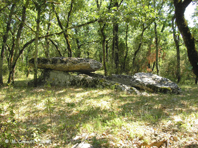
Tombe du Géant (Septfonds) submitted by thecaptain on 25th Jan 2006. This dolmen is a nice one, still partially within its mound. The chamber is made with two long side slabs, each 5 metres in length, and with a nicely shaped and fitted backstone between them. The capstone has broken, and only half of it now remains.
(View photo, vote or add a comment)
Log Text: The Tombe du Géant is a scheduled historic monument, and as such it is marked on the local maps, both 1:25,000 and 1:100,000, near to the farm of Les Tombes to the southeast of Septfonds. It is however not so easy to find in the real world, with the fields and indeed many of the trackways in this area having recently been thoroughly fenced off, with both barbed wire and electric fences, and new hedges planted. At first, I could find no way through to this dolmen, and as it is in a bit of woodland, there was no way I could see anything from nearby either. Before giving up totally, I thought I would try an approach from a different angle, and indeed, there is a new trackway made, which takes one around the newly fenced off land. It is complex to describe, but starting from a point well to the south of where the dolmen is marked, take the signed PR.1 footpath firstly to the east for a couple of hundred metres, and then having passed the end of the first field and passed into some woods, turn left to the north and follow the trackway for about 500 metres where you will then find the Tombe du Géant in the woodland to the left of the path.
The dolmen is a nice one, still partially within its mound. The chamber is made with two long side slabs, each 5 metres in length, and with a nicely shaped and fitted backstone between them. The capstone has broken, and only half of it now remains. The chamber is 4.5 metres long by 1.5 metres wide internally, and as usual faces to the east. This would be a very pleasant spot, but for all the flies buzzing around and the humming and crackling power lines passing almost directly overhead. There are probably several other dolmens to be found in the locality, judging by certain names on the maps.
Dolmen de Caux-Vieilles
Trip No.205 Entry No.32 Date Added: 19th Oct 2020
Site Type: Burial Chamber or Dolmen
Country: France (Midi:Tarn-et-Garonne (82))
Visited: Yes on 2nd Sep 2005. My rating: Condition 2 Ambience 3 Access 4
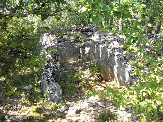
Dolmen de Caux-Vieilles submitted by TheCaptain on 6th Nov 2007. A bit to the south of the track running along the southern edge of the airfield, in the scrubland, are several mounds of stones.
One of these mounds has a clear dolmen chamber within it, but was very difficult to photograph with all the trees and bushes around it.
I am lead to believe that there are many dolmens to be found within these woodlands, far more than the three that I found.
(View photo, vote or add a comment)
Log Text: A bit to the south of the track running along the southern edge of the airfield, in the scrubland, are several mounds of stones. One of these mounds has a clear dolmen chamber within it, 3 metres in length by 1.5 metres in width. It consists of two side slabs and a backstone between them, but no capstone. The northern half of the mound still exists right up to the top of the side support, while the southern part is mostly missing. This chamber is very difficult to photograph with all the trees and bushes around it. I am lead to believe that there are many dolmens to be found within these woodlands, far more than the three that I found.
Finelle Dolmen
Trip No.205 Entry No.31 Date Added: 19th Oct 2020
Site Type: Burial Chamber or Dolmen
Country: France (Midi:Tarn-et-Garonne (82))
Visited: Yes on 2nd Sep 2005. My rating: Condition 4 Ambience 3 Access 4
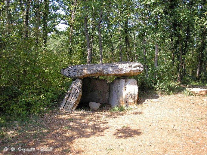
Finelle Dolmen submitted by TheCaptain on 6th Nov 2007. A bit to the west along the track running along the southern edge of the airfield, and you soon come to another dolmen.
This one has lost its mound, which has no doubt been used to build the local walls, and it is standing proud at the edge of a flat area used for dumping rubble etc.
(View photo, vote or add a comment)
Log Text: A bit to the west of the first dolmen, along the track running along the southern edge of the airfield, and you soon come to another dolmen. This one has lost its mound, which has no doubt been used to build the local walls, and it is standing proud at the edge of a flat area used for dumping rubble etc. Its a fairly standard southern French dolmen, with two 4 metre long sideslabs and a backstone between them, topped with a capstone, making a chamber 3 metres by 2 metres. There is some evidence of a front closing stone, and the chamber faces eastwards on a bearing of 095°.
Dolmen de Peyrelevade (Septfonds)
Trip No.205 Entry No.30 Date Added: 19th Oct 2020
Site Type: Burial Chamber or Dolmen
Country: France (Midi:Tarn-et-Garonne (82))
Visited: Yes on 2nd Sep 2005. My rating: Condition 3 Ambience 3 Access 5
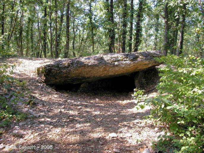
Dolmen de Peyrelevade (Septfonds) submitted by TheCaptain on 6th Nov 2007. Right beside the track is the first dolmen you come to. It is still mostly within its mound of loose stone, and quite a large one.
(View photo, vote or add a comment)
Log Text: To the west of the village of Septfonds, and to the south of the little airfield are several dolmens in the woodlands. There are signposts to "dolmens" and down a little track is a parking place and more signs. Right beside this track is the first dolmen you come to. It is still mostly within its mound of loose stone, and quite a large one. The 5 metres by 4 metres capstone sits on top of a chamber 4 metres in length, by 2 metres wide, made with the usual 2 large sideslabs and a back stone, but these stones are completely below ground level. The chamber opens to the east, on a bearing of about 080°. To the west of the main dolmen are a couple of other long side set slabs near to the roadside, where the mound has been cut away. Perhaps this is the remains of a secondary burial chamber ? The mound diameter is about 15 metres. There are lots of strange red topped mushrooms / toadstools poking up through the ground here. Very interesting.
Dolmen de Cieurac
Trip No.205 Entry No.29 Date Added: 19th Oct 2020
Site Type: Burial Chamber or Dolmen
Country: France (Midi:Lot (46))
Visited: Couldn't find on 1st Sep 2005
Log Text: Just over the Dordogne river from the town of Souillac should be found this dolmen. There are no signposts to it, and its not on any of my maps, but it is mentioned in a book I have, and is supposedly to be found at a corner of the road in the woods at the top of the hill. However, the woods are very thick and dense, and the hillside very steep, so without any better information, there is no way I am going to find this one.
Dolmen de la Route Vieille
Trip No.205 Entry No.28 Date Added: 19th Oct 2020
Site Type: Burial Chamber or Dolmen
Country: France (Limousin:Corrèze (19))
Visited: Couldn't find on 1st Sep 2005
Log Text: There is supposed to be a dolmen here, according to my notes, but there is nothing mentioned on any of my maps or on any of the village noticeboards or tourist publicity. Churches, a Chateau and caves are all mentioned, but no dolmen. Perhaps the dolmen is in a different village called Noailles.
Puy de Pauliac Cromlech
Trip No.205 Entry No.27 Date Added: 19th Oct 2020
Site Type: Stone Circle
Country: France (Limousin:Corrèze (19))
Visited: Yes on 1st Sep 2005. My rating: Condition 4 Ambience 4 Access 4

Puy de Pauliac Cromlech submitted by thecaptain on 17th Feb 2006. In a clearing on the forest covered slopes, the cromlech is made with many stones, nearly all less than a metre tall, set up almost touching each other making an enclosure which is a sort of rounded square about 40 to 50 metres across.
(View photo, vote or add a comment)
Log Text: At the top of the lovely Puy de Pauliac hill to the east of the historical village of Aubazines, is an orientation table, and fantastic views stretching for many miles in nearly all directions, with the high point of the Massif Central, the Puy de Sancy to be seen way off in the east. Near to the top of this hill is marked a cromlech, and I almost didn't find it. The cromlech can be found a bit downhill to the north of the summit, and it is signposted, although the tiny little wooden sign is easily missed, hiding in the woodland.
In a clearing in the forest covered slopes, the cromlech is made with many stones, nearly all less than a metre tall, set up almost touching each other making an enclosure which is a sort of rounded square about 40 to 50 metres across. At the southern, upslope side, is a large outcrop of natural rocks, probably 10 to 15 metres high from which the cromlech extends, joining between other significant natural rocks, to close off the area.
It is very easy to imagine a gathering of people here, with the leader stood on top of the large natural rocks giving his sermon. Within the cromlech are several nicely weathered natural granite slabs, one of which has a large break in it. These would make good seats for the best view !
Dolmen de Rochesseux
Trip No.205 Entry No.26 Date Added: 19th Oct 2020
Site Type: Burial Chamber or Dolmen
Country: France (Limousin:Corrèze (19))
Visited: Yes on 1st Sep 2005. My rating: Condition 4 Ambience 4 Access 4

Dolmen de Rochesseux submitted by thecaptain on 15th Feb 2006. This little dolmen is found in a sort of parkland high up on the slopes of Puy de Pauliac, above the historical village of Aubazines in Corrèze.
(View photo, vote or add a comment)
Log Text: This little dolmen is found in a sort of parkland high up on the slopes of Puy de Pauliac, above the historical village of Aubazines. It is signposted from the road. A triangular 3 metres by 2 metres capstone sits delicately balanced on top of two side support stones and a back stone, with a chamber 2.5 metres long by 1 metre wide underneath. The two side stones are both pointed at the top, and the capstone sits only on their points, and the small backstone almost at the same place, overhanging substantially in all directions. The chamber faces eastwards, at a bearing of 080°. The capstone has a lovely ring to it when knocked.
Estivaux Dolmen
Trip No.205 Entry No.25 Date Added: 19th Oct 2020
Site Type: Burial Chamber or Dolmen
Country: France (Limousin:Corrèze (19))
Visited: Yes on 1st Sep 2005. My rating: Condition 3 Ambience 3 Access 4
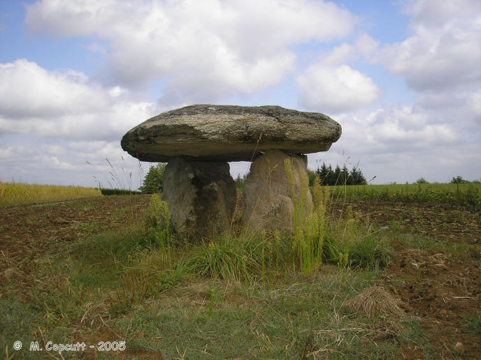
Estivaux dolmen submitted by thecaptain on 13th Feb 2006. To the east of the village of Estivaux, this dolmen can be found in a field near to the sports stadium and a new housing development, just about 50 metres from the road.
(View photo, vote or add a comment)
Log Text: To the east of the village of Estivaux, this dolmen can be found in a field near to the sports stadium and a new housing development, just about 50 metres from the road. Its an odd little affair, and almost looks modern. The oval capstone, 3.5 m by 2.5 m sits on top of 4 support stones making a small chamber 2 metres by 1 metre inside, and about 1.5 metres in height. The support stones look to me to be quite new, perhaps an enthusiastic restoration job has been done, and it is all a bit too level. Unfortunately two of the support stones have been painted blue, and the ambience of the place is spoiled by the power cables directly overhead.
Dolmen dit La Maison du Loup
Trip No.205 Entry No.24 Date Added: 19th Oct 2020
Site Type: Burial Chamber or Dolmen
Country: France (Limousin:Corrèze (19))
Visited: Yes on 1st Sep 2005. My rating: Condition 3 Ambience 4 Access 3
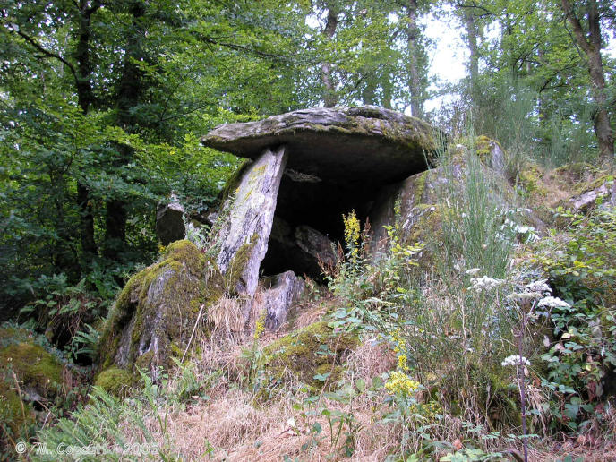
Dolmen dit La Maison du Loup submitted by thecaptain on 13th Feb 2006. This dolmen is found in thick woodland on the end of a defended headland overlooking the Vézère river, and is at the top of a cliff edge. The dolmen is in part made from natural rocks, with a couple of sideslabs and a capstone (now broken into two pieces) resting on a rocky outcrop.
(View photo, vote or add a comment)
Log Text: About a kilometre from the village of Espartignac, this dolmen can be found along a signposted track from the village square near to the Bar Le Dolmen. It is found in thick woodland on the end of a defended headland overlooking the Vézère river, and is at the top of a cliff edge. The dolmen is in part made from natural rocks, with a couple of sideslabs and a capstone (now broken into two pieces) resting on a rocky outcrop. The capstone is about 3 metres by 2 metres, and sits about 2 metres above the floor of the chamber.
The headland has been fortified for many hundreds of years, perhaps even thousands. But what can be seen today, with a Motte surrounded by another flat and defended area, dates to post Roman times. There are also double ditches and banks at the south to defend from the landward side of the headland not surrounded by the river. This place is at the site of an important ford across the Vézère river, on the important route from northern France to the Mediterranean.
Doghouse Hill
Date Added: 18th Oct 2020
Site Type: Ancient Village or Settlement
Country: England (Dorset)
Visited: Saw from a distance on 15th Oct 2020
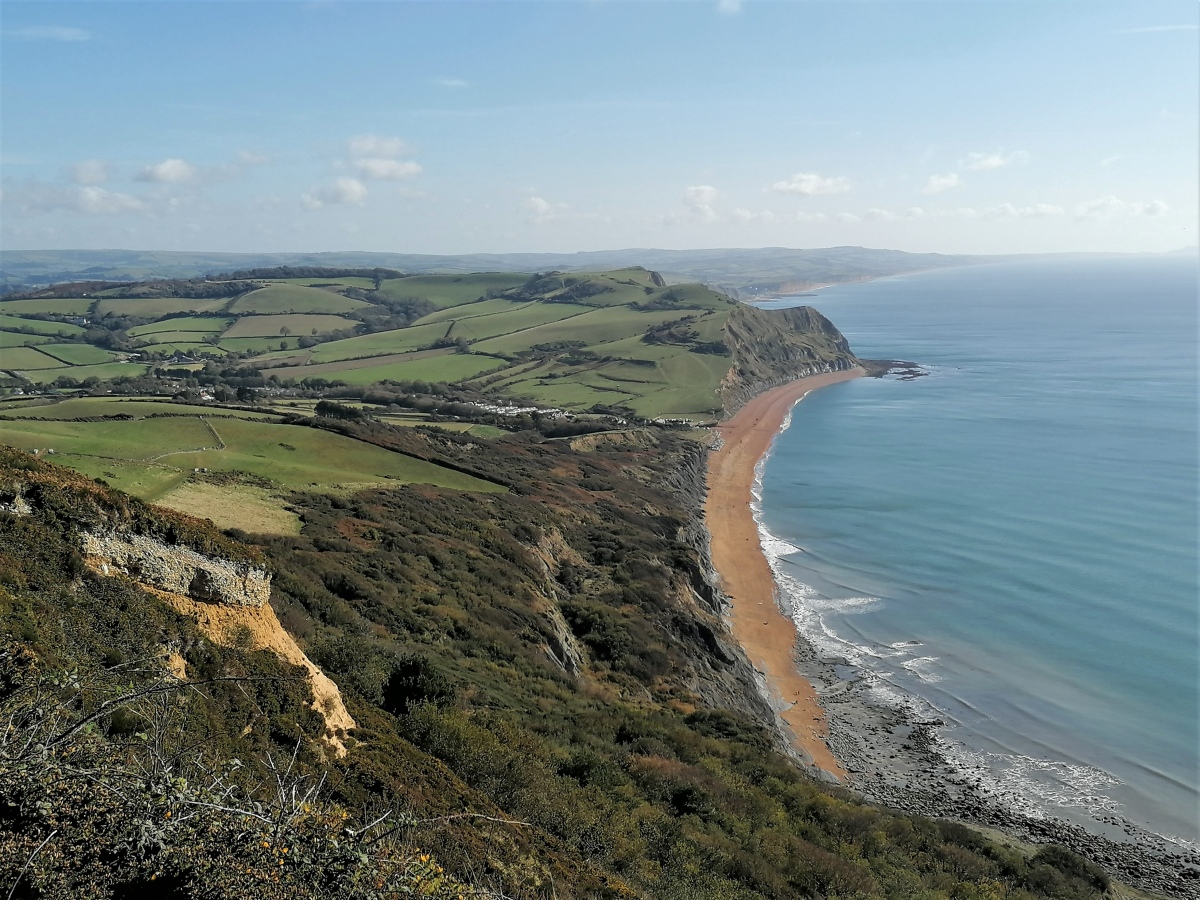
Doghouse Hill submitted by TheCaptain on 18th Oct 2020. Seen from the top of Golden Cap, Doghouse Hill is the central of the three hilltops in the mid distance, just inland from the headland cliffs.
(View photo, vote or add a comment)
Log Text: Seen from a distance during a walk from Seatown up the coast path up and over the Golden Cap and around Stanton St Gabriel and back.
Dyrham Camp
Date Added: 17th Oct 2020
Site Type: Hillfort
Country: England (Gloucestershire)
Visited: Yes on 9th Sep 2007
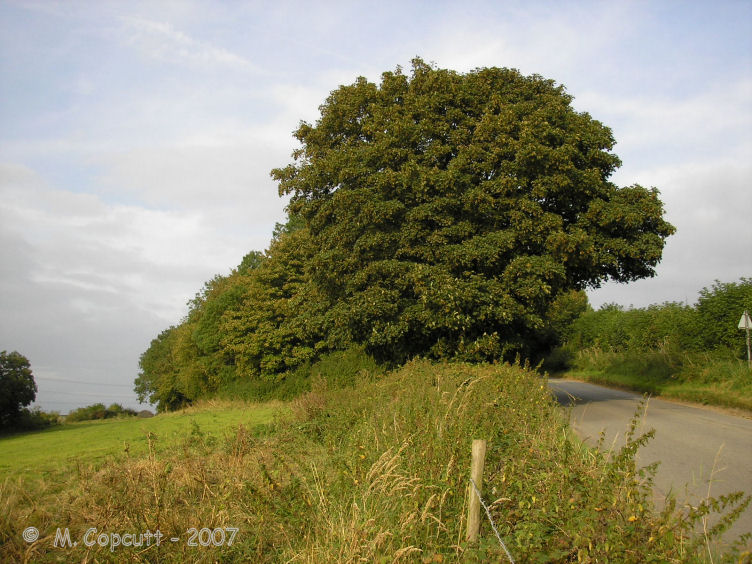
Dyrham Camp submitted by thecaptain on 28th Aug 2008. The western "point" of Hinton Hillfort, where it is cut into two by the little road up the hillside from the village of Hinton below.
(View photo, vote or add a comment)
Log Text: Dyrham Camp, otherwise known as Hinton Hillfort, is not so much a hillfort, but more a promontary fort, on a southwest facing spur of the Cotswold Hills north of Bath. Basically triangular in shape, it is cut into two by the little road up the hillside from the village of Hinton below. The northern part is mostly in woodland, and seems to be used as a rubbish dump these days. The hill edge has been shaped, and in places the bank and ditch is in fine condition, perhaps kept in shape in more recent times for drainage. The southern half of the fort is open pasture with a public footpath running through, and the steep southern slopes are sort of terraced, with several almost cliff like ramparts, below which are quite spectacular remains of ancient field systems. The eastern edge of the fort, where the land is flat on top of the Cotswold plateau, has a large ditch and bank in place across the headland. The ditch is about 10 metres wide and 2 metres deep, with a bank up to 4 metres high on the inside, which even these days is a fairly good barrier to entry.
Dyrham Camp
Date Added: 17th Oct 2020
Site Type: Hillfort
Country: England (Gloucestershire)
Visited: Yes on 9th Oct 2020
Dyrham Camp submitted by Thorgrim on 22nd Aug 2003. Dyrham Camp, otherwise known as Hinton Hillfort, is best seen from high land in Dyrham Park (National Trust) Dating from the Iron Age, it was the likely site of the Battle of Dyrham in 577 AD when the Anglo-Saxon Chronicle tells us that the invading Saxons under "Cuthwine and Ceawlin fought against the Britons and slew three kings, Coinmail, Condidan and Farimail at the place which is called Dyrham; and they captured three cities, Gloucester, Cirencester and Bath"
(View photo, vote or add a comment)
Log Text: Walking a loop on the Cotswold Way around Dyrham and Tormarton, see Hinton Hillfort from the southern side in the fading autumn sunlight.
