Contributory members are able to log private notes and comments about each site
Sites TheCaptain has logged. View this log as a table or view the most recent logs from everyone
Priddy Circles N
Date Added: 29th Oct 2019
Site Type: Henge
Country: England (Somerset)
Visited: Yes on 25th Oct 2011
Priddy Circles N submitted by theCaptain on 25th Oct 2011. Priddy Northern circle, June 2011.
Seen here looking west from the B3134, it is quite difficult to make the circle out, but it is mostly to be seen. Look over the three foreground fences, then you see lumps and bumps of the eastern arc. The next wall and fence cut the circle pretty much in half, and the western arc is quite clear beyond that as it is where all the dark bushes are growing.
(View photo, vote or add a comment)
Log Text: None
Priddy Circles C
Date Added: 29th Oct 2019
Site Type: Henge
Country: England (Somerset)
Visited: Yes on 22nd Oct 2011
Priddy Circles C submitted by theCaptain on 22nd Oct 2011. Priddy Central circle, June 2011.
Looking north at the eastern edge where the wall cuts the circle
(View photo, vote or add a comment)
Log Text: None
Presqu'île de la Torche
Trip No.203 Entry No.470 Date Added: 25th May 2020
Site Type: Passage Grave
Country: France (Bretagne:Finistère (29))
Visited: Yes on 17th Jun 2005. My rating: Condition 3 Ambience 5 Access 4

Presqu'île de la Torche submitted by thecaptain on 18th May 2009. The remains of what would no doubt have once been a magnificent monument, is positioned on top of this little headland, almost an island, sticking dramatically out into the wild Atlantic Ocean, and surrounded by magnificent surf beaches.
(View photo, vote or add a comment)
Log Text: The remains of what would no doubt have once been a magnificent monument, positioned on top of this little, almost an island, headland, sticking dramatically out into the wild Atlantic Ocean, and surrounded by magnificent surf beaches.
The central passage is still 16 metres in length, running up and over the top of the mound, curving as it goes, and opening to the east. At the west end there is an upright end stone. On the top of the mound, a few metres in from the end stone, are two side chambers each about 3 metres by 1.5 metres, one of which still has capstones in place, although it is all much ruined. Considering the concrete all around, for wartime bunkers and lookout posts, and for tourist paths and observation tables, it is surprising anything has survived here - that so much has is incredible. There is possible some remnants of a second chamber up here too.
The most wonderful thing about this place is the situation. The surf is crashing in all around the end of the point, and the waves rolling by on both sides of the headland in this surfers paradise. Its a fantastic place to sit and watch the waves go by. I love it. It makes me want to go surfing again. I bet I could still do it. They are even playing Camel's "Snow Goose" in the bar at the car park. Now if that isn't meaningful......
Predannack Cross
Date Added: 28th Jun 2023
Site Type: Ancient Cross
Country: England (Cornwall)
Visited: Yes on 12th Jun 2023. My rating: Condition 4 Ambience 4 Access 4
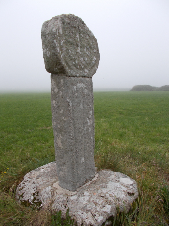
Predannack Cross submitted by AngieLake on 29th Jun 2016. The rear of Predannack Cross and a misty field.
(View photo, vote or add a comment)
Log Text: A walk from Mullion Cove to Predannack and back along the cliffs. This lovely cross is in a corner of a field.
Prédaire Dolmen
Trip No.203 Entry No.30 Date Added: 1st Apr 2020
Site Type: Chambered Cairn
Country: France (Pays de la Loire:Loire-Atlantique)
Visited: Yes on 14th May 2005. My rating: Condition 2 Ambience 5 Access 4
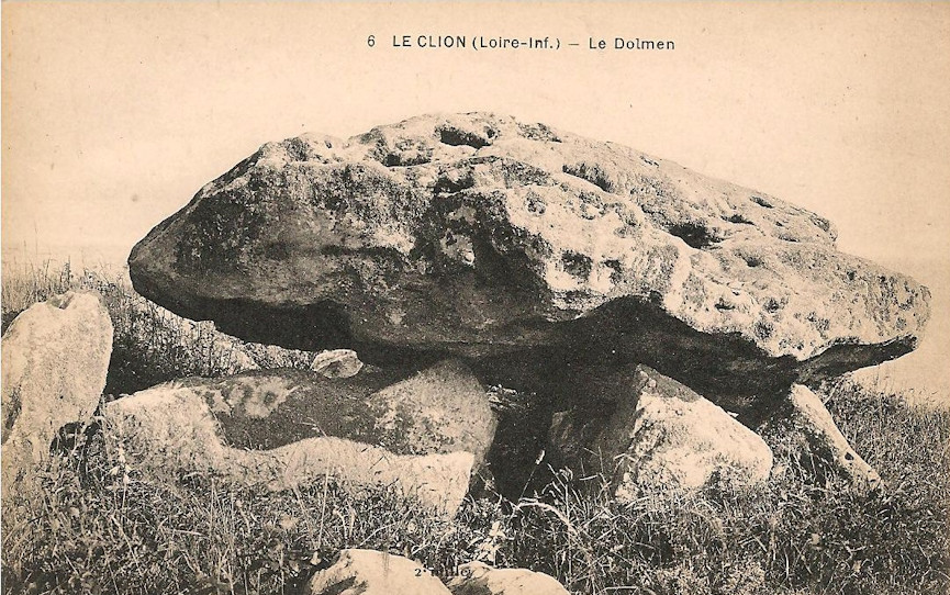
Prédaire Dolmen submitted by TheCaptain on 12th Oct 2018. From ichel Baconnais
Le dolmen du Pré d'air. Jusque vers 1970, ce lieu était recouvert d'épineux. Pour des raisons touristiques, la végétation a été enlevée, et le sol s'est érodé très vite. Ainsi, en 2003, la pierre du sommet présentant un danger, a été enlevée à la hâte sans repérage préalable. Aujourd'hui, ce site ruiné par la main de l'homme, n'est plus qu'un tas de pierraille. L'endroit était autrefois connu sous le nom "Perder" ou "Peurdaire", ce qui signifiait les ...
(View photo, vote or add a comment)
Log Text: This much ruined transepted burial mound sits on a clifftop overlooking the sea to the south of the seaside harbour town of Pornic. I had chosen to spend the night at the campsite la Boutinardière and went for an evening stroll for 20 minutes or so northwest along the Sentier des Douarniers coastal footpath past some strange jetties with boat lifts jutting into the sea at the foot of the cliffs before reaching the dolmen as the sun was going down.
The main entrance corridor is about 7 metres long and is orientated on a bearing of 142° which looks directly towards a nearby headland. There are two large transept chambers each about 2.8 m by 1.7 metres in size but only a single smaller end chamber perhaps about 2.2 by 2 metres in size. Strangely situated side on to the slope maybe the shape of the ground has changed significantly over the millennia.
Just up the slop from the remains is a very large stone which is possibly the remains of a large capstone but perhaps just a boulder placed here to prevent vehicles driving down over the remains from the fields above. It was apparently excavated in 1878 with finds from the Neolithic which are now in the Musée Dobrée in Nantes.
Pré-de-Roi Menhir
Trip No.205 Entry No.135 Date Added: 10th Nov 2020
Site Type: Standing Stone (Menhir)
Country: France (Midi:Tarn (81))
Visited: Yes on 16th Sep 2005. My rating: Condition 4 Ambience 3 Access 5
Pré-de-Roi menhir submitted by theCaptain on 1st Nov 2010. The Pré-de-Roi menhir is 2.5 metres tall and looks for all the world like it should be carved into a statue menhir.
Perhaps it once was, and all the features have been eroded away by several thousand years of being in the open.
(View photo, vote or add a comment)
Log Text: The Pré-de-Roi menhir is found right beside the road to the west of Murat, just beyond the road to the village of Candoubre. It is 2.5 metres tall, nearly 2 metres wide, and looks for all the world like it should be carved into a statue menhir. Perhaps it once was, and all the features have been eroded away by several thousand years of being in the open. A nice menhir anyway.
Prat Meur menhir
Trip No.203 Entry No.530 Date Added: 29th May 2020
Site Type: Standing Stone (Menhir)
Country: France (Bretagne:Finistère (29))
Visited: Yes on 22nd Jun 2005. My rating: Condition 3 Ambience 3 Access 4

Prat Meur menhir submitted by thecaptain on 24th Jan 2009. This is a pleasant enough menhir, stood in a field beside a trackway at the end of the lane from the port to Prat Meur hamlet.
(View photo, vote or add a comment)
Log Text: This is a pleasant enough menhir, probably 2.8 metres tall and nearly as wide, but less than a metre thick. It is stood in a field beside a trackway at the end of the lane from the port to Prat Meur hamlet. It is nicely weathered at the top.
Somebodies air force is out and about, looks like F.16s so it isn't the French. Probably on holiday at Landivisiau. Suddenly there's a commotion, and a dog barking. A large rabbit or hare flashes past me about 5 metres away, with a dog hotly in chase about 15 metres behind. The rabbit is across a field of artichokes and into a hedge before the dog, and it all goes quiet, before a man is out and whistling to the dog. An interesting little episode.
Prajou-Menhir menhir
Trip No.203 Entry No.554 Date Added: 3rd Jun 2020
Site Type: Standing Stone (Menhir)
Country: France (Bretagne:Côtes-D'Armor (22))
Visited: Yes on 24th Jun 2005. My rating: Condition 3 Ambience 4 Access 4

Prajou-Menhir menhir submitted by regina on 30th Sep 2018. The little menhir next to the Allée couverte.
(View photo, vote or add a comment)
Log Text: The "indicator menhir" just outside and in front of the allée couverte. It is about 1.7 metres high but nicely weathered.
Prajou-Menhir menhir
Trip No.193 Entry No.13 Date Added: 13th Jul 2020
Site Type: Standing Stone (Menhir)
Country: France (Bretagne:Côtes-D'Armor (22))
Visited: Yes on 30th May 1993

Prajou-Menhir menhir submitted by regina on 30th Sep 2018. The little menhir next to the Allée couverte.
(View photo, vote or add a comment)
Log Text: Cycling camping trip of north Brittany, day 2. Tregastel, Ile Grande, Tel Star Satellite place. Snake! Lots of ancient stones.
Prajou-Menhir allée couverte
Trip No.203 Entry No.555 Date Added: 3rd Jun 2020
Site Type: Passage Grave
Country: France (Bretagne:Côtes-D'Armor (22))
Visited: Yes on 24th Jun 2005. My rating: Condition 4 Ambience 4 Access 4

Prajou-Menhir allée couverte submitted by greywether on 26th Jun 2005. From the W. The art is in the end cell in the foreground. June 1994
(View photo, vote or add a comment)
Log Text: This is a terriffic allée couverte approaching 14 metres long and facing towards its indicator menhir at orientation 103°. Seven capstones of varying sizes are still in place, the two westernmost being the covers for a separate end cell of about 2.5 metres length. Within this end cell are many carvings, including pairs of breasts, cartouches, palettes and many others. Approaching 2 metres wide, it is not much more than a metre in height.
It has probably been helped in its survival by being incorporated into a wall at some stage in the past, but of which all immediate traces have now been removed.
It is easily found in a little grassy area just to the south of the road to Ile Grande, with a signpost, and is a part of a local "Megalith Trail", details of which can be obtained from the local tourist office. There are several other menhirs in this area of land, just above the high tide level and marshy.
Prajou-Menhir allée couverte
Trip No.193 Entry No.14 Date Added: 13th Jul 2020
Site Type: Passage Grave
Country: France (Bretagne:Côtes-D'Armor (22))
Visited: Yes on 30th May 1993

Prajou-Menhir allée couverte submitted by greywether on 26th Jun 2005. From the W. The art is in the end cell in the foreground. June 1994
(View photo, vote or add a comment)
Log Text: Cycling camping trip of north Brittany, day 2. Tregastel, Ile Grande, Tel Star Satellite place. Snake! Lots of ancient stones.
Pouzac Dolmen
Trip No.204 Entry No.153 Date Added: 17th Aug 2020
Site Type: Burial Chamber or Dolmen
Country: France (Poitou:Vienne (86))
Visited: Couldn't find on 20th Jul 2005
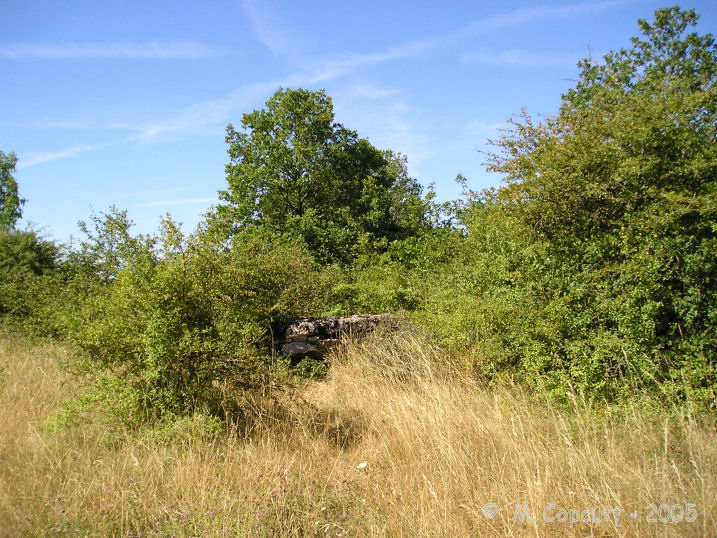
Pouzac dolmen submitted by TheCaptain on 3rd Dec 2007. Even having the detailed map of the area, finding this dolmen was not easy.
It is to be found in the side of the hedge, and is getting rather overgrown.
(View photo, vote or add a comment)
Log Text: I could find absolutely no sign of this. I should have the few minutes extra in the shop to have a look at or buy the 1:25000 map, rather than think I could go without.
Pouzac Dolmen
Trip No.204 Entry No.155 Date Added: 17th Aug 2020
Site Type: Burial Chamber or Dolmen
Country: France (Poitou:Vienne (86))
Visited: Yes on 21st Jul 2005. My rating: Condition 3 Ambience 3 Access 4
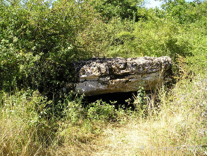
Pouzac dolmen submitted by TheCaptain on 3rd Dec 2007. It is a little limestone simple dolmen, with its entrance towards the east.
(View photo, vote or add a comment)
Log Text: Even having the detailed map, finding this dolmen was not easy. Go south along the track from the east end of the hamlet of Pouzac, then go right at the crossroads of trackways. Go along here for 100 metres and then the dolmen is to be found in the southern side of the southern hedge, and is getting a bit overgrown. It is a little limestone simple dolmen, with a capstone about 3 m by 2 m sat up off the ground on several broken support stones, with its entrance towards the east.
Poueyferré Tumulus
Trip No.205 Entry No.52 Date Added: 25th Oct 2020
Site Type: Chambered Tomb
Country: France (Midi:Hautes-Pyrénées (65))
Visited: Yes on 6th Sep 2005. My rating: Condition 4 Ambience 3 Access 4
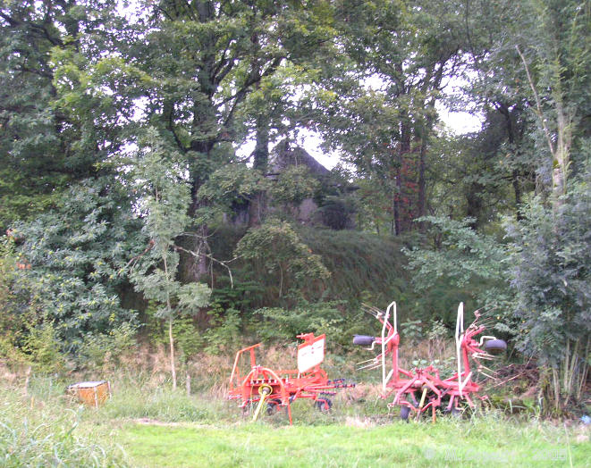
Poueyferré Tumulus submitted by thecaptain on 24th Jan 2006. A few kilometres to the northwest of Lourdes near to Poueyferré, this large "Christianised" tumulus can be found.
It is about 30 metres in diameter, and 5 metres high with quite steep sides, and has a chapel and relatively modern tomb built onto the top of it.
The woodland is fenced off, so complete access to the tumulus is not possible, and as the undergrowth is quite thick, getting decent pictures is not easy.
(View photo, vote or add a comment)
Log Text: A few kilometres to the northwest of Lourdes, on the eastern side of the D.940 road near to Poueyferré, take the minor road down into the dip to the hamlet of Maillous, where this large tumulus can be found. To get to the tumulus, which can be seen from the road, walk down a little trackway which leads to the south beside a couple of houses. The trackway runs out at a little woodland, and the tumulus is contained within this wood.
It is about 30 metres in diameter, and 5 metres high with quite steep sides, and has a relatively modern tomb built onto the top of it. The woodland is fenced off, so complete access to the tumulus is not possible, and as the undergrowth is quite thick, getting decent pictures is not easy.
Just to the north of the large mound, about 40 metres away, is the remains of what looks to have been another tumulus, now mostly ploughed out and lost into the fields, except for a small bit still covered with trees. It has become horribly wet again here, with thunderstorms rumbling all around.
Pouey-Mayou
Trip No.205 Entry No.51 Date Added: 25th Oct 2020
Site Type: Burial Chamber or Dolmen
Country: France (Midi:Hautes-Pyrénées (65))
Visited: Yes on 6th Sep 2005. My rating: Condition 3 Ambience 3 Access 3
Pouey-Mayou submitted by TheCaptain on 10th Dec 2010. Having spent a fair while searching in the thick undergrowth, I found a way leading through to something stonelike.
(View photo, vote or add a comment)
Log Text: To the southwest of the town of Tarbes, and the village of Osson, take the unmarked road to the south. Partway along this road is a parking area, picnic site and a map of footpath circuits in the area. However, continue further until the road runs out and turns into a dirt track. From here, the Pouey-Majou dolmen should now be signposted on yellow footpath signs, but basically turn left, then left again and walk up to the top of the hill, about a kilometre from where I was able to park.
The dolmen is to be found in a large mound, one of many large mounds along this hilltop ridge, but the only one easily and relatively readily accessible without doing a whole days walk to Bartres. The top of the mound has been dug into to reveal a large stone lined chamber about 7 metres long by 3 metres wide, with a single capstone still in place at the eastern end.
It is all very overgrown and difficult to see clearly, let alone get good photos of. It doesn't help that its been raining heavily for 24 hours, and everything is soaking wet. The mound is probably 40 metres in diameter, and up to 4 or 5 metres high. The level of the top of the remaining capstone is at least 2 metres below the level of the mound here.
Porz Guen Dolmens
Trip No.203 Entry No.431 Date Added: 23rd May 2020
Site Type: Burial Chamber or Dolmen
Country: France (Bretagne:Morbihan (56))
Visited: Yes on 15th Jun 2005. My rating: Condition 2 Ambience 5 Access 4
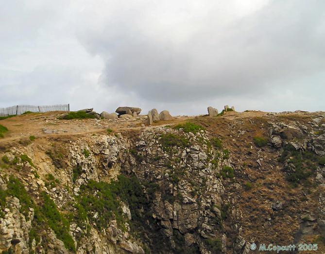
Porz Guen dolmens submitted by thecaptain on 14th Jun 2006. Remains of two dolmens which can be found on the clifftop to the north of the Porz Guen beach on the Cote Sauvage of the Quiberon Peninsula, just a few minutes walk around the spectacular cliff path from various parking places.
(View photo, vote or add a comment)
Log Text: Found on the clifftop to the north of the Porz Guen beach on the Cote Sauvage of the Quiberon Peninsula, just a few minutes walk around the spectacular cliff path from various parking places.
These are the remains of two ruined dolmens with entry corridors facing to the south east, probably once within the same large mound, and possibly also remains of a third. The more inland is the most complete, with one capstone surviving on the entry couloir. The chamber is about 3 m by 3 m rectangular and would have been roofed with large corbelled capstones around it, many of which survive. The second chamber is only half there, with some of it now gone over the cliff edge. It has an oval chamber, and a long corridor of which several stones survive. There are other upright positioned stones between the two.
This really is a spectacular place, overlooking a splendid rough sea with surfers out in it below. Excellent.
Porz Ar Stréat menhir
Trip No.203 Entry No.531 Date Added: 29th May 2020
Site Type: Standing Stone (Menhir)
Country: France (Bretagne:Finistère (29))
Visited: Yes on 22nd Jun 2005. My rating: Condition 4 Ambience 3 Access 4
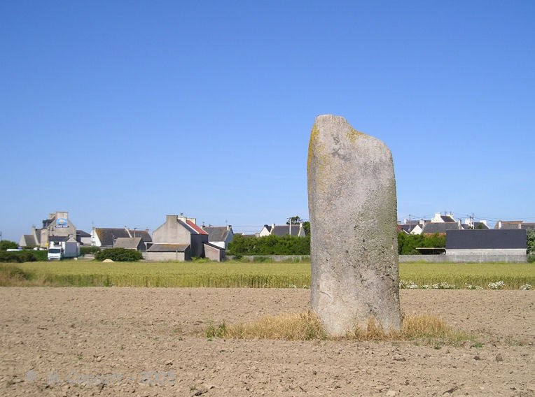
Porz Ar Stréat menhir submitted by thecaptain on 24th Jan 2009. This is a nice menhir in a field not far from the harbour, only a couple of hundred metres from the main village centre.
(View photo, vote or add a comment)
Log Text: This is a nice menhir in a field not far from the harbour, only a couple of hundred metres from the main village centre. Its over 4 metres high and a sort of square section, but tapered at the top, and it has a nice lean.
I cant get right up to it for details though, and its a pity about all the refrigerated lorries at the fish plant nearby making a racket, and a very smelly farmyard.
Porthmeor Stone
Date Added: 18th Sep 2010
Site Type: Standing Stone (Menhir)
Country: England (Cornwall)
Visited: Yes on 7th Oct 2008
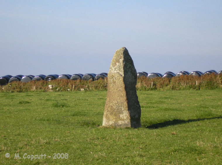
Porthmeor Stone submitted by thecaptain on 7th Oct 2008. Porthmeor menhir as seen from the roadside, September 2008
(View photo, vote or add a comment)
Log Text: None
Porthmeor Circle
Date Added: 18th Sep 2010
Site Type: Stone Circle
Country: England (Cornwall)
Visited: Yes on 24th Feb 2004
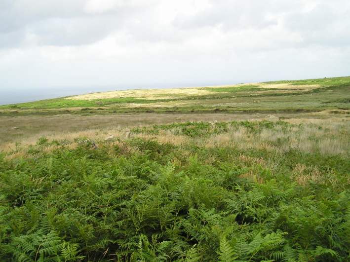
Porthmeor Circle submitted by TheCaptain on 24th Feb 2004. Treen Common stone circle, also known as Porthmeor
I knew nothing of this very ruined circle until I found it in the excellent Belerion book. So I just had to go and have a look.
It is largely an embanked ring with plenty of stones sticking up out of the top in a very haphazard way. It is possibly the remains of a henge, rather than a proper stone circle.
This picture was taken from a high point on the embankment, and can be seen curving away to the right, more by the dark green of t...
(View photo, vote or add a comment)
Log Text: None
Porth Hellick Down
Date Added: 11th Oct 2020
Site Type: Burial Chamber or Dolmen
Country: England (Isles of Scilly)
Visited: Yes on 8th Sep 1986
Porth Hellick submitted by Thorgrim on 2nd Jul 2003. Porth Hellick Down entrance grave on St Mary's, Scilly SV 9284 1083. This is the largest and best preserved out of a complex of 8 on the Downs.
(View photo, vote or add a comment)
Log Text: During a 2 week sailing trip with friends, I left the rest of the crew to sail L'Aurian from St Mary's all the way round the Western Rocks and in to New Grimsby harbour, Tresco for the night. I spent the day walking round the entire coast of St Mary's visiting many ancient sites, before catching a ferry over to Bryher in the evening and getting picked up by the crew.
