Contributory members are able to log private notes and comments about each site
Sites TheCaptain has logged. View this log as a table or view the most recent logs from everyone
Pierres Droites (Monteneuf)
Trip No.204 Entry No.1 Date Added: 22nd Jun 2020
Site Type: Stone Row / Alignment
Country: France (Bretagne:Morbihan (56))
Visited: Yes on 9th Jul 2005. My rating: Condition 5 Ambience 5 Access 5
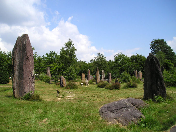
Pierres Droites (Monteneuf) submitted by thecaptain on 24th Aug 2005. A view of the wonderful Pierres Droites, in the forest near Monteneuf.
(View photo, vote or add a comment)
Log Text: The true extent of these stones was only discovered in the last 20 years or so after a forest fire, yet this set of aligned menhirs is probably one of the most important in France. A visitor centre has been set up with interactive displays which show erection of menhirs, building of neolithic homes, crop growing, archaeological excavations etc etc.
Several hundred megaliths have been found here, of which many have now been re-erected in their original socket holes. I found it quite difficult to make out any patterns to what is here, perhaps there are several lines converging, or perhaps there are circles? Many of the stones are quite big, one being over 5 metres tall and 30 tonnes in weight, yet others are little side set slabs. Most are the local schist, yet some are blocks of white quartz, moved here from a good distance away.
This place is most intriguing, and somewhere I need to find out more about.
La Pièce Couverte
Trip No.204 Entry No.5 Date Added: 22nd Jun 2020
Site Type: Passage Grave
Country: France (Bretagne:Morbihan (56))
Visited: Couldn't find on 9th Jul 2005
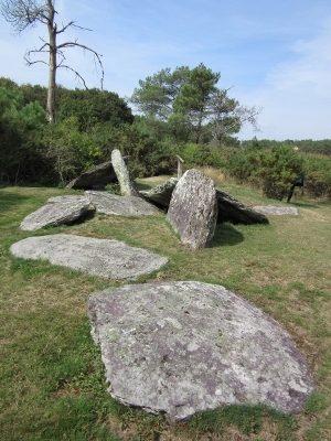
La Pièce Couverte submitted by negus on 13th Sep 2014. Site in Bretagne:Morbihan (56) France
(View photo, vote or add a comment)
Log Text: This is now not much more than a line of a dozen or so slabs positoned in a line of about 10 metres length, and is probably the remains of an allée couverte. Several of the slabs are marked with cupules and symbols.
Les Bordouès
Trip No.204 Entry No.3 Date Added: 22nd Jun 2020
Site Type: Passage Grave
Country: France (Bretagne:Morbihan (56))
Visited: Yes on 9th Jul 2005. My rating: Condition 3 Ambience 3 Access 4
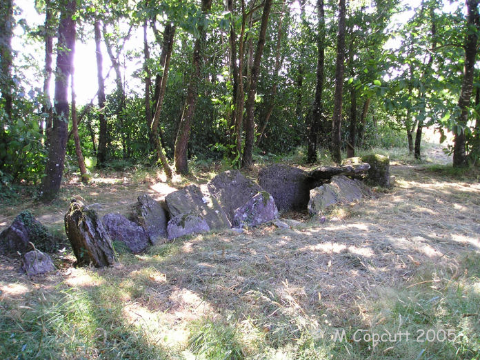
Les Bordouès submitted by TheCaptain on 2nd Jun 2007. This is the remains of a small allée couverte, 8 metres long and 1.5 metres wide.
There is a small entry porchway, separated from the main chamber by a large slab, at the southeast end.
(View photo, vote or add a comment)
Log Text: This is the remains of a small allée couverte, 8 metres long and 1.5 metres wide, with only one capstone still in place. There is a small entry porchway, separated from the main chamber by a large slab, at the southeast end. Excavations in 1976 found amongst other things five polished axes. Much of its oval mound still remains. It is to be found about a kilometres marked walk through the forest from the Monteneuf visitor centre.
Lande de Rousse
Trip No.204 Entry No.7 Date Added: 22nd Jun 2020
Site Type: Standing Stones
Country: France (Bretagne:Morbihan (56))
Visited: Yes on 9th Jul 2005. My rating: Condition 2 Ambience 3 Access 4
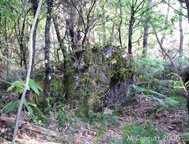
Lande de Rousse submitted by TheCaptain on 2nd Jun 2007. Deep into the forest is what looked to me to be a row of fallen menhirs, with one large rock still protruding from the ground.
It wouldn't surprise me if there was another row here, like some of those at the nearby Pierres Droites, or perhaps something like La Pièce Couverte.
(View photo, vote or add a comment)
Log Text: Beside the track to the Loge Morinais is marked a menhir on the local maps. I had a good look around, and deep into the forest is what looked to me to be a row of fallen menhirs, with one large rock still protruding from the ground. It wouldnt surprise me if there was another row here, like those at the nearby Pierres Droites, or La Pièce Couverte.
La Roche Blanche
Trip No.204 Entry No.4 Date Added: 22nd Jun 2020
Site Type: Round Cairn
Country: France (Bretagne:Morbihan (56))
Visited: Yes on 9th Jul 2005. My rating: Condition 3 Ambience 3 Access 3
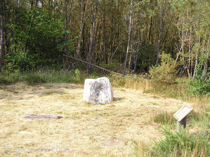
La Roche Blanche submitted by TheCaptain on 2nd Jun 2007. This is a nice shining white quartz block within a circle of local schist stones.
It is thought to probably mark the grave of an individual, rather than being a collective grave.
(View photo, vote or add a comment)
Log Text: This is a nice shining white quartz block within a sort of circle of local schist stones. It is thought to probably mark the grave of an individual, rather than being a collective grave. It can be found about a kilometres walk from the Monteneuf visitors centre, through the forests along a marked trail.
La Loge Morinais
Trip No.204 Entry No.6 Date Added: 22nd Jun 2020
Site Type: Passage Grave
Country: France (Bretagne:Morbihan (56))
Visited: Yes on 9th Jul 2005. My rating: Condition 3 Ambience 4 Access 3

La Loge Morinais submitted by TheCaptain on 3rd Jun 2007. La Loge Morinais, near Monténeuf.
(View photo, vote or add a comment)
Log Text: This is the remains of an allée couverte made of the local purple schist, and can be found in the forest to the north east of the Monteneuf visitors centre, about a kilometre away along a signposted trail. It is about 13 metres long and has an orientation of due east to west. There is an entrance lobby at the east end, and an antichamber at the west, but no capstones remain in place.
It can be easily found from several places with signposted forest walks. The day I was here, there was a nearby target set up for the prehistoric shooting championships.
Mont St Michel
Trip No.203 Entry No.604 Date Added: 13th Jun 2020
Site Type: Ancient Village or Settlement
Country: France (Normandie:Manche (50))
Visited: Yes on 28th Jun 2005. My rating: Condition 5 Ambience 2 Access 4
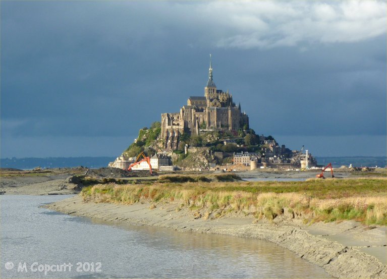
Mont St Michel submitted by theCaptain on 4th Jan 2013. They are trying to cut off the Mont again, to get the sea to surround it once more.
I read at the new controlling dam on the river that the land has risen 4.9 metres since the 1960s. Much of these new grassy marshes is being dug up and pushed into the river, hopefully to get washed away.
(View photo, vote or add a comment)
Log Text: Far too hot and busy and crowded.
La Maison des Feins
Trip No.203 Entry No.600 Date Added: 13th Jun 2020
Site Type: Passage Grave
Country: France (Bretagne:Ille-et-Vilaine (35))
Visited: Yes on 28th Jun 2005. My rating: Condition 5 Ambience 5 Access 4
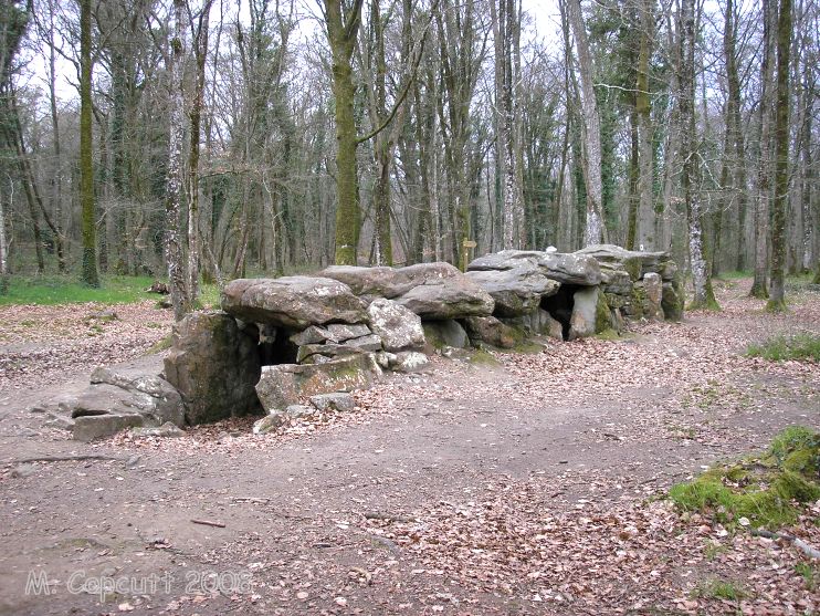
La Maison des Feins submitted by thecaptain on 15th Apr 2008. La Maison des Feins, Tressé, seen here from the "front" end, as approached through the forest.
So this will be the northern side from the east.
(View photo, vote or add a comment)
Log Text: This is a lovely little allée couverte, deep inside a lovely oak forest just to the east of the village of Tressé, and signposted from there. There is a parking area, and a signposted and guided walk footpath from there to find it, along with many other items of interest.
The allée is about 12 metres long, at an orientation of 155°, but it is not much more than a metre wide or high. Truly a house for the fairies. All but the end capstone are still in place, and at the back end there is a nice little additional cell. Within this cell are some exceptional carvings on the southern sidestone, of two pairs of breasts with their collars, on a cartouche giving them a big relief. There are also the remains of two pairs on the chevet stone, but these have been crudely hacked off in the past, leaving just the outlines.
Of course, there are many legends of the fairies who live here in this forest, including the story of a farmer who was given some everlasting bread by the fairies because their cow had become ill, and the farmer had helped them with it. The bread would stay fresh and last forever so long as he never told the story. Of course, one day the farmer did tell the story, and the loaf of bread turned to stone - a stone which can still be seen here today.
Champ Dolent Menhir
Trip No.203 Entry No.602 Date Added: 13th Jun 2020
Site Type: Standing Stone (Menhir)
Country: France (Bretagne:Ille-et-Vilaine (35))
Visited: Yes on 28th Jun 2005. My rating: Condition 5 Ambience 5 Access 5
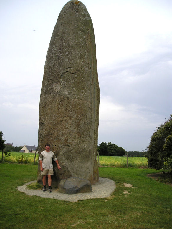
Champ Dolent menhir submitted by thecaptain on 6th Jul 2005. Champ Dolent menhir.
At more than 9 metres tall, its a bigg 'un.
(View photo, vote or add a comment)
Log Text: This is a glorious 9 metre tall shaped and sculpted granite menhir, the stone for which has been brought here from over 4 kilometres away. It stands high on a little hillock overlooking the ancient city of Dol, with the rock which has been inhabited for many thousands of years just beyond that. At its base is another small and polished stone, the origins of which are unknown.
Looking carefully at parts of the stone in the shadow, and it wouldn't surprise me if there are carvings on it. Having seen St Samson, it seems possible to make out various crosses and lines and daggers. Or is this just me seeing things now ?
This is of course another stone surrounded by legends and folklore. It is said to be here to commemorate a great battle perhaps. It is also said that it was thrown down from the sky by an over seeing being in order to separate two fighting brothers. Whatever, it is a most wonderful stone. Come and see it for yourselves.
St-Benoit polissoir
Trip No.203 Entry No.605 Date Added: 13th Jun 2020
Site Type: Polissoir
Country: France (Normandie:Manche (50))
Visited: Yes on 28th Jun 2005. My rating: Condition 4 Ambience 4 Access 5
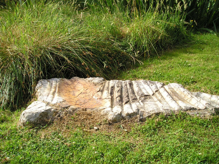
St-Benoit polissoir submitted by thecaptain on 14th Oct 2005. St Benoit polissoir, near St James.
Not a million miles from Mont St Michel, this lovely polissoir stone is nowadays nicely kept in a little garden type area beside the lane.
(View photo, vote or add a comment)
Log Text: I was understanding that this polissoir stone was going to be difficult to find, but thought that I'd give it a go. Luckily for me, since the source of my information was written, it's all been tidied up into a nice little area and signposted. It's about 800m from the village of St Bénoit, up the D.363 to the east, beside the little stream.
The stone itself is a sort of white quartz, about 1.2 metres in length and flat on the ground. In the top face are three polishing bowls, one large, and up to 16 polishing grooves. The little stream which provides its water source to lubricate the polishing is rich in iron ore, and this has caused the stone to stain a rust red colour in its cracks and grooves.
The stone has been dated to 4000BC. Legends have become associated with such a stone, one being that it can cure colic in horses if they are walked around the stone three times, then made to drink the iron rich water within its basins.
Terriffic, I love these polissoir stones.
La Roche Longue (St-Marcan)
Trip No.203 Entry No.603 Date Added: 13th Jun 2020
Site Type: Standing Stone (Menhir)
Country: France (Bretagne:Ille-et-Vilaine (35))
Visited: Yes on 28th Jun 2005. My rating: Condition 3 Ambience 3 Access 3
La Roche Longue (St-Marcan) submitted by thecaptain on 6th Mar 2007. Probably 3 to 4 metres tall, in a field near the cemetary to the east of the village of St Marcan, on a slope overlooking the marshes of the bay of Mont St Michel.
(View photo, vote or add a comment)
Log Text: A large slab sided menhir, about 3 metres tall with its wide sides oriented east and west, in a field near to the cemetary to the east of the village of St Marcan, on a slope overlooking the marshes of the bay of Mont St Michel. Whilst I couldn’t get right to it, the menhir is easily visible from the roadside. About 800 metres to the south of this menhir used to stand another similar menhir 2 metres tall, which was destroyed in the 1930s
Four-És-Feins
Trip No.203 Entry No.599 Date Added: 13th Jun 2020
Site Type: Passage Grave
Country: France (Bretagne:Ille-et-Vilaine (35))
Visited: Couldn't find on 28th Jun 2005
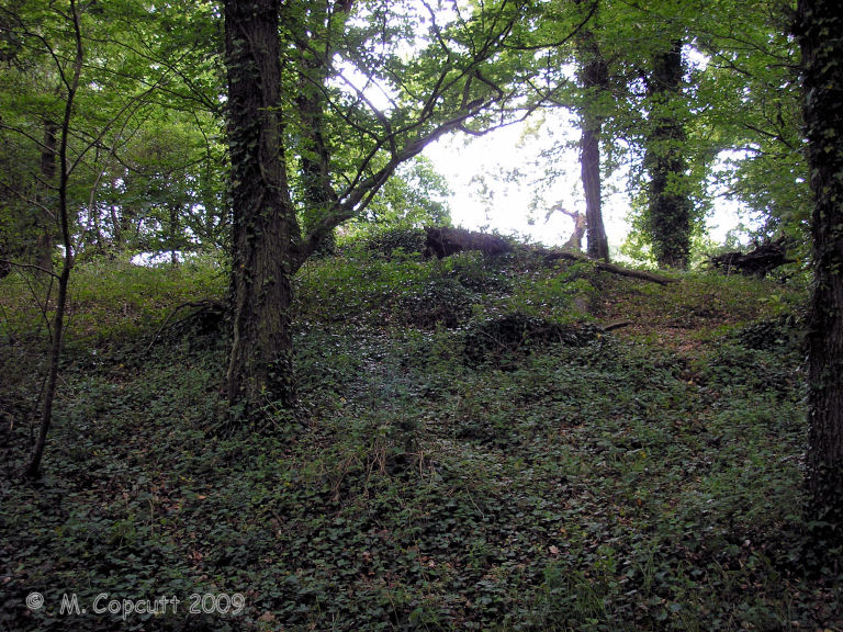
Four-És-Feins submitted by thecaptain on 20th Jun 2009. I found a place in a woodland to the left of the track, with a mound in it, and what looked to be some lumps sticking up, but it was very overgrown. It has to be here, surely. Closer inspection amongst the ivy and brambles, and there were clearly a few side set slabs sticking up through the ground.
(View photo, vote or add a comment)
Log Text: I had a good look around for the remains of this allée couverte, but could find nothing obvious. It's somewhere to the west of the hamlet of Vieux Bourg, beside the north to south expressway.
La Ganterie
Trip No.203 Entry No.598 Date Added: 13th Jun 2020
Site Type: Passage Grave
Country: France (Bretagne:Côtes-D'Armor (22))
Visited: Yes on 28th Jun 2005. My rating: Condition 2 Ambience 2 Access 4
La Ganterie submitted by thecaptain on 7th Mar 2007. The allée couverte is signposted along a trackway into a wood, and just 50m along this well tended path the remains are to be found. It is almost impossible to see what is here though, as it is all extremely overgrown.
(View photo, vote or add a comment)
Log Text: Just beside the D.676 Dinan to Dol road, at the top of the hill to the east of the hamlet of La Ganterie where the road is a dual carriageway, there is a place to park. From here the allée couverte is signposted along a trackway into a wood, and just 50m along this well tended path the remains are to be found. It is almost impossible to see what is here though, as it is all totally overgrown. It might be a very long allée couverte going by the length of the bramble growth.
I find it very odd that the signposts and path are so well tended, yet the monument is so completely neglected. Never mind, it is still here with us.
Menhir dit la Pierre du Domaine
Trip No.203 Entry No.601 Date Added: 13th Jun 2020
Site Type: Standing Stone (Menhir)
Country: France (Bretagne:Ille-et-Vilaine (35))
Visited: Yes on 28th Jun 2005. My rating: Condition 3 Ambience 3 Access 4
Menhir dit la Pierre du Domaine submitted by thecaptain on 8th Mar 2007. This 4 metre tall menhir can be found just to the west of the road around the east side of Beaufort lake, a bit to the north of the Abbey.
It was in a field of wheat when I visited, but can be easily seen.
(View photo, vote or add a comment)
Log Text: This menhir can be found just to the west of the road around the east of Beaufort lake, a bit to the north of the Abbey. It's in a field of wheat, but can be easily seen. I estimate it to be at least 4 metres tall.
Champ des Roches
Trip No.203 Entry No.596 Date Added: 10th Jun 2020
Site Type: Multiple Stone Rows / Avenue
Country: France (Bretagne:Côtes-D'Armor (22))
Visited: Yes on 27th Jun 2005. My rating: Condition 4 Ambience 5 Access 4

Champ des Roches submitted by thecaptain on 2nd Jul 2005. Signpost at the site.
(View photo, vote or add a comment)
Log Text: Just behind the churchyard to the south of the village of Pléslin and well signposted is this “field of rocks” which is kept in a nice and shady oak garden and included on a couple of signposted local walks. I didn’t know of this place beforehand despite having been near it several times before, it not being far from St-Malo, yet it is described as Brittany’s third most important site (which seems a bit over the top considering some of the other places).
What it basically consists of these days is about 70 big white quartz stones arranged in 5 lines perhaps 6 which are not quite parallel as they converge towards the east and apparently focus on a large stone of which I found no obvious evidence. It really is a nice quiet calming place away from all the busy roads and bustle of this part of Brittany.
Why are these stones here ? Well legend tells us it was the fairies who were building Mont St-Michel who got tired carrying their stones out to sea and they dropped them here.
Just to the north of the stones is an open field with various structures within it which is used for a festival each year to celebrate the stones. It’s been happening longer than anyone can tell on or around the Fete St Pierre. This year (2005) the “Fête des Megalithes” will happen on Saturday July 16th and there will be a big feast bands playing dancing and fireworks. Within this festival ground there is a large gravel circle with 8 telegraph poles arranged around the outside and then a further 4 at the cardinal points positioned outside them. Various other poles are dotted about some with white painted bottoms some with black. I like to think it is for some ancient dancing and festivity but my sister told me it was probably for a large tent. Surely any tent would come with its own poles !
As I said I didn’t know of this lovely place before I learn something every day. It had a lovely atmosphere and was very pleasant to just sit there in the shade.
La Hautière
Trip No.203 Entry No.593 Date Added: 10th Jun 2020
Site Type: Passage Grave
Country: France (Bretagne:Côtes-D'Armor (22))
Visited: Yes on 27th Jun 2005. My rating: Condition 4 Ambience 3 Access 4
La Hautière submitted by theCaptain on 18th Mar 2014. This is a fairly large allée couverte in a field to the east of the D.768 road between Créhen and Trégon, which had just been cropped for hay when I visited in 2005, so it was easy to get to.
(View photo, vote or add a comment)
Log Text: This is a fairly large allée couverte in a field to the east of the D.768 road between Créhen and Trégon, which had just been cropped for hay when I visited, so it was easy to get to. The main passage is about 14 metres long, oriented to 155°, and has 6 capstones still in place. Many of the sidestones have fallen inwards, so there is not much of a covered passageway left, more a long pile of stones ! The large western endstone can still be seen in its place though.
Ville Bellanger allée couverte
Trip No.203 Entry No.589 Date Added: 10th Jun 2020
Site Type: Passage Grave
Country: France (Bretagne:Côtes-D'Armor (22))
Visited: Yes on 27th Jun 2005. My rating: Condition 3 Ambience 3 Access 5
Ville Bellanger allée couverte submitted by theCaptain on 19th Mar 2014. Just beside the D.52 road can be found this allée couverte, either in somebody's garden, or a little public area beside.
(View photo, vote or add a comment)
Log Text: Just beside the D.52 road, 3 km north of the village, and a km south of La Bouille and all its industrial sites, can be found this allée couverte, either in somebodies garden, or a little public area besides. The remains are a bit of a jumble, but an allée almost 10 metres long aligned at 050° is clear. Whether it has an external cell at the western end, or whether its a fallen capstone I can not be sure, but the chamber appears to be divided. A pleasant little find, and lots of nice foxgloves growing here at the time of my visit.
Ville Génouhan allée couverte
Trip No.203 Entry No.592 Date Added: 10th Jun 2020
Site Type: Passage Grave
Country: France (Bretagne:Côtes-D'Armor (22))
Visited: Yes on 27th Jun 2005. My rating: Condition 3 Ambience 3 Access 4
Ville Génouhan allée couverte submitted by theCaptain on 20th Mar 2014. Remains of a fairly standard looking allée couverte 12 metres long with still 6 capstones in place. Most of the sidestones seem to have collapsed inwards, making much of it look like not much more than a long pile of stones.
(View photo, vote or add a comment)
Log Text: Just to the south of the busy D.786 road between ND de Guildo and Trégon can be found the remains of this allée couverte. I find it strange that although it is signposted, has got a little parking area, is kept within a little grassed area within a field of maize, and has got several hundred metres of well tended footpath to it, the monument itself is left to become thoroughly overgrown.
It's the remains of a fairly standard looking allée couverte 12 metres long with orientation 125°, and there are still 6 capstones in place. Most of the sidestones seem to have collapsed inwards, making much of it not much more than a long pile of stones.
Doigt de Gargantua (Côtes-D'Armor)
Trip No.203 Entry No.591 Date Added: 10th Jun 2020
Site Type: Standing Stone (Menhir)
Country: France (Bretagne:Côtes-D'Armor (22))
Visited: Yes on 27th Jun 2005. My rating: Condition 4 Ambience 3 Access 4

Doigt de Gargantua (Côtes-D'Armor) submitted by thecaptain on 26th Oct 2008. When I was here on a late June afternoon in 2005, the bushes surrounding the giant's finger had grown substantially since my previous visit several years earlier, and now the views from here are severely limited. Before there was a tremendous panorama of all the sea and headlands around, and with the fort below.
(View photo, vote or add a comment)
Log Text: This 2.5 metre tall, thin menhir stands guard beside the footpath overlooking the splendid Forte de la Latte, at the headland of the same name to the east of Cap Fréhel. On a late June Monday afternoon it was very busy here, and getting a space in the car park was a problem. The bushes surrounding the giant's finger have grown substantially since my last visit several years ago, and now the views from here are severely limited. Before there was a tremendous panorama of all the sea and headlands around, and with the fort below. Not so now.
Dolmen de Ville Goudier
Trip No.203 Entry No.595 Date Added: 10th Jun 2020
Site Type: Passage Grave
Country: France (Bretagne:Côtes-D'Armor (22))
Visited: Yes on 27th Jun 2005. My rating: Condition 3 Ambience 3 Access 3

Dolmen de Ville Goudier submitted by thecaptain on 20th Dec 2008. Marked as a menhir on the ign maps, there is a large stone standing here which can be seen from the D.768 road across a field of wheat, underneath a pine tree near to the Trégon water tower.
(View photo, vote or add a comment)
Log Text: Marked as a menhir on the ign maps, this large standing stone can be seen from the D.768 road across a field of wheat, about 100 metres away and underneath a pine tree near to the Trégon water tower. I could initially see no way of getting any nearer, and I estimated it to be about 2 metres high. However, I later found a way round the back.
The stone is about 2 metres tall and fairly chunky. There are lots of other large stones around here also, perhaps field clearance, or perhaps this is the remains of a tomb of some kind.
