

Contributory members are able to log private notes and comments about each site
Sites StoneTracker has logged. View this log as a table or view the most recent logs from everyone
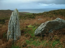
Tarlton Cross
Trip No.1 Entry No.17 Date Added: 29th Jun 2026
Site Type: Artificial Mound
Country: United States (Ohio)
Visited: Yes on 1st Jan 2021. My rating: Condition 2 Ambience 5 Access 4
")
Tarlton Cross submitted by mobial on 19th Mar 2014. TarltonCross-altar The "altar" Tarlton Cross - "altar" Image copyright: Mobial (Mike Osswald), hosted on Flickr and displayed under the terms of their API.
(View photo, vote or add a comment)
Log Text: None
Pecos National Historical Park
Trip No.1 Entry No.16 Date Added: 24th Jun 2026
Site Type: Ancient Village or Settlement
Country: United States (New Mexico)
Visited: Yes on 1st May 2026. My rating: Condition 3 Ambience 5 Access 3
")
Pecos National Historical Park submitted by stonetracker on 22nd Jun 2026. One of what were likely dozens of underground kivas in the pueblo complex. A few have been partially restored. Others, like this one, have been excavated only to a small extent to show what the walls looked like.
(View photo, vote or add a comment)
Log Text: This is a historical park run by the National Park Service. It comprises extensive Ancestral Pueblo ruins from Pueblo 3 and 4 period as well as a restored Spanish mission church. A 1 to 1.5 mile interpretive loop trail runs through the site, some of it suitable for wheelchair access. It involves only a slight elevation gain to access a long ridge where the ruins are located. As is usually the case with National Parks, there is a visitor center with exhibits, rest rooms, and plenty of parking.
To get to the visitor center from Albuquerque NM, take I-25 N for approximately 76 miles to Exit 299 for NM-50 toward Glorieta/Pecos. Take the exit, turn left over the I-25 overpass and then right to continue east on NM-50. In 6 miles, turn R onto NM-60 S and continue for about 2 miles. Turn right onto Peach Drive which is the park entrance to the visitor center,
La Cieneguilla Petrolyphs
Trip No.1 Entry No.15 Date Added: 11th Jun 2026
Site Type: Rock Art
Country: United States (New Mexico)
Visited: Yes on 1st May 2026. My rating: Condition 3 Ambience 5 Access 3
")
La Cieneguilla Petrolyphs submitted by stonetracker on 10th Jun 2026. One of the first panels you see along the canyon face at Cieneguilla. Detailed views to follow. There are literally 100s of petroglyphs here. Access is via a 1/4 to 1/2 mie trail along a fence line to an opening and then a steep rock scramble maybe 100 yds to the top of the cliff face and the panels. See visitor log and videos.
The site is managed by the BLM. From their web site:
"Hundreds of petroglyphs, dating from pre-contact time and the Spanish colonial era, can be found along t...
(View photo, vote or add a comment)
Log Text: This is a historic site owned and managed by the Bureau of Land Management. It is located on the outskirts of Santa Fe NM near the Santa Fe Regional Airport. There is parking in an unpaved lot for at least ten vehicles and the trail to the petroglyphs starts here. There is an information kiosk approximately 100 ft down the path to the fence line with a map of the area and interpretation on the El Camino Real, a prehistoric Native American trail and later an important Spanish American trade route, that passed through this area.
Getting to the petroglyph site requires a slightly less than 1/2 mile easy walk south along a fence line to an obvious opening in the fence on the right. The way there is sporadically marked with posts and white arrows. A maze of informal trails leads up the hill from there to the rocks of top of the cliff face where the petroglyphs are located. Although short, be advised that this hill is steep with a lot of loose rock and a certain amount of weaving between large boulders is required to get to the top.
To get to the parking lot from Albuquerque, follow I-25 N 48 miles to Exit 271 toward La Cienega/Farm to Market 50 F. In 0.2 mile, turn left onto Entrada La Cienega. In 1 mile, continue onto Los Pinos Rd. In 1 mile, continue onto Paseo Real. The parking lot is 2.5 miles further on the left.
Arroyo Hondo Pueblo
Trip No.1 Entry No.14 Date Added: 8th Jun 2026
Site Type: Ancient Village or Settlement
Country: United States (New Mexico)
Visited: Couldn't find on 1st May 2026. My rating: Ambience 4
")
Arroyo Hondo Pueblo submitted by stonetracker on 7th Jun 2026. The trailhead and parking area for the northern side of the Arroyo Hondo Open Space conservation land. The original site of the Arroyo Hondo Pueblo is supposedly viewable from high points on the trail network, but I have no exact coordinates for the ruins.
(View photo, vote or add a comment)
Log Text: I attempted to find this site with limited location information and was unable to find it. I later found out that the ruins are likely not within the boundaries of the Arroyo Hondo Open Space but about 1000 feet west of its westernmost trails on private property near a residential area at the following coordinates: 35.62127, -105.93212.
Unless one obtains permission to access the site from the residential subdivision, only remote viewing is possible from one of the westernmost high points on the Arroyo Hondo Open Space trail network. I intend to confirm this on a subsequent visit.
There are two parking lots and trail heads for the Open Space tract: a northern one and a southern one. To get to the northern lot from Albuquerque, take I-25 North for 58 miles to exit 282 for US-84 N towards US-285 N. In a 1/4 mile, take the exit towards Frontage Rd and merge onto South St Francis Dr. Take an immediate L into Rabbit Rd. In 2 miles, turn R onto NM-466 S. In 0.3 mile, turn L onto Old Agua Fria Rd E. The entrance will be 0.7 mile on the R.
There is ample parking, a porta-potty, and some limited trail interpretation.
Tsankawi
Trip No.1 Entry No.13 Date Added: 6th Jun 2026
Site Type: Ancient Village or Settlement
Country: United States (New Mexico)
Visited: Yes on 1st May 2026. My rating: Condition 2 Ambience 5 Access 2
")
Tsankawi submitted by stonetracker on 31st May 2026. One last ladder and now on the mesa top with stunning views of the canyon and mountains near Los Alamos and Santa Fe.
(View photo, vote or add a comment)
Log Text: The complete Tsankawi Village loop trail is about 2 miles round trip. The parking lot is large, paved, and there are rest rooms at the trail head and a covered picnic area. Parking is not free; either a cash/credit fee (honor system) or a free National Parks pass is required on your dashboard for access. I've been told there is a trail guide available for purchase although the guard shack was not open when I visited in early May. Frankly it is not necessary to enjoy the walk.
There is no disabled or wheelchair access on this particular trail. Also the trail is VERY exposed to the elements with little or no shelter from storms. Check the weather carefully before you go. Otherwise the usual desert hiking tips apply: sunscreen, hat, and lots of water. Although much of the trail is flat, you will need to be able to climb up or down ladders at times and follow a twisty trail on the canyon face with a steep dropoff at times and no guard or handrails.
To get there from Albuquerque, follow the directions in the visitor log for the main Bandelier National Monument site (Frijoles Canyon) until you get to the junction of NM-502 and NM-4. At this point stay on NM-4 for approximately a mile to the top of the hill. The trail parking lot will be on your left.
Bandelier National Monument - Tyuonyi Overlook Village Pueblo
Trip No.1 Entry No.12 Date Added: 30th May 2026
Site Type: Ancient Village or Settlement
Country: United States (New Mexico)
Visited: Yes on 1st May 2026. My rating: Condition 2 Ambience 4 Access 2
")
Bandelier National Monument - Tyuonyi Overlook Village Pueblo submitted by stonetracker on 30th May 2026. The 5 or 6 excavated room blocks of the village pueblo. There are quite a few other unexcavated rooms nearby. See videos in comments for more.
(View photo, vote or add a comment)
Log Text: This pueblo site is about a 1/2 to 3/4 mile mostly flat hike down the Tyuonyi Overlook Trail that runs along the top of the mesa above Frijoles Canyon. The trailhead is not at the main Bandelier visitor center but in back of the shuttle bus parking lot near an amphitheater at Juniper Campground. The campground is shortly after the fee station on a road to the right.
The trail starts at a kiosk in the lot and those coordinates are ~ 35.795458, -106.281626. Walk down the trail into a hollow next to the amphitheater and you will shortly see signage for the trailhead.
About 300 ft down the trail, there is a right trail fork to an agricultural exhibit. Stay left. After about another 1/4 to 1/2 mile there is another trail fork. Stay on the left again. Continue for a bit to a slight decline and another trail fork. The pueblo ruins are on the left fork maybe 100 ft from the main trail at about 35.789827, -106.280268.
To get to Juniper Campround from Albuquerque, follow the directions in the visitor log for the main Bandelier article to the entrance station. The entrance to the campground is on a right-hand side road about 200 yds from the park entrance.
Bandelier National Monument
Trip No.1 Entry No.11 Date Added: 30th May 2026
Site Type: Ancient Village or Settlement
Country: United States (New Mexico)
Visited: Yes on 1st May 2026. My rating: Condition 3 Ambience 4 Access 3
")
Bandelier National Monument - Frijoles Canyon Cliff Dwellings submitted by durhamnature on 25th Feb 2013. Photo of the cave houses, from "Ancient Ruins..." via archive.org
(View photo, vote or add a comment)
Log Text: Many of the prehistoric Ancestral Pueblo sites are accessible from the Pueblo Loop Trail which starts behind the visitor center at the main Bandelier NM unit in Frijoles Canyon. Much of the Pueblo Loop Trail, with the exception of the side trail to the cavates, is paved and wheelchair accessible.
This is a popular park, so parking at the visitor center can fill up quickly and there is an entry fee for vehicles and passengers unless you have an America the Beautiful parks pass. In fact, access to the visitor center parking lot and its trailheads from 9 am to 3 pm is only possible via a shuttle bus from White Rock NM during the peak season of mid May to mid Oct. The shuttle runs frequently. Also, all trails at Bandelier, whether at the main unit or the outlying trailheads are only open to hiking from dawn to dusk so plan accordingly. Since many of these regulations are subject to change, consult the park website for the latest news. I chose to visit in the off season to avoid the parking issues ;-).
To get to the main Frijoles Canyon unit and visitor center from Albuquerque, take I-25 north for 52 miles and take exit 276 for NM-599 N. Continue on NM-599 for 13 miles and take the US-84 N/US-285 exit toward Española. Continue on US-84 N for approx 14 miles and take the NM-502 W/Los Alamos exit. Continue on NM-502 for 10 miles and take the NM-4 exit towards White Rock and Bandelier NM. Continue on NM-4 for approximately 13 miles and turn left into the signposted park entrance and fee station. Shortly after the fee station, a side road to the right leads to Juniper Campground. Go past that and continue about 3 more miles on the entrance road to the visitor center.
Bandelier National Mounument - Tyuonyi
Trip No.1 Entry No.10 Date Added: 30th May 2026
Site Type: Ancient Village or Settlement
Country: United States (New Mexico)
Visited: Yes on 1st May 2026. My rating: Condition 3 Ambience 4 Access 3
")
Bandelier National Mounument - Tyuonyi submitted by bat400 on 26th Feb 2013. Tyuonyi Pueblo. Only one of the three kivas within the circle of the building has been excavated.
Photo by bat400, April 2012.
(View photo, vote or add a comment)
Log Text: Part of the Pueblo Loop Trail in Bandelier National Monument. The Tyuonyi Pueblo complex is about 0.4 of a mile hike from the visitor center and a few hundred feet NW of the great kiva.
See the main Bandelier National Monument article for more information about directions and accessibility.
Bandelier National Monument - Long House
Trip No.1 Entry No.9 Date Added: 30th May 2026
Site Type: Ancient Village or Settlement
Country: United States (New Mexico)
Visited: Yes on 1st May 2026. My rating: Condition 2 Ambience 4 Access 3
")
Bandelier National Monument - Long House submitted by bat400 on 26th Feb 2013. Long House pueblo.
Photo by bat400, April 2012.
(View photo, vote or add a comment)
Log Text: Part of the Pueblo Loop Trail in Bandelier National Monument. If you proceed directly from the visitor center and skip the cavate side trail that climbs the cliff face, the start of Long House is about 0.6 of a mile hike from the visitor center and the room blocks continue for about 0.2 of a mile beyond that before the trail loops down and back.
See the main Bandelier National Monument article for more information about directions and accessibility.
Casamero
Trip No.1 Entry No.8 Date Added: 25th May 2026
Site Type: Ancient Village or Settlement
Country: United States (New Mexico)
Visited: Yes on 1st May 2026. My rating: Condition 2 Ambience 5 Access 4
")
Casamero submitted by bat400_photo on 9th Apr 2014. IMG_0814-15 pan copy
Photo by Bob Cates, October 12, 2007.
Among the stabilized walls of Casamer Pueblo Ruin.
All Rights Reserved Among the stabilized walls of Casamer Pueblo Ruin. Image copyright: Hiker Bob (Bob Cates), hosted on Flickr and displayed under the terms of their API.
(View photo, vote or add a comment)
Log Text: Casamero Ruins are located in Prewitt NM. They are a short 300 yd hike over a mostly flat desert scrubland trail from a small dirt parking area maintained by the BLM. There is no water or shade, so take the usual precautions when hiking in the desert. The trailhead is signposted and starts just beyond a gap in the livestock fence.
To get there from Albuquerque, take I-40 west for 93 miles to Exit 63 for NM 412 towards Prewitt. At the top of the ramp turn right into Pillowcrest Rd for 0.2 mile and turn right again onto NM 122 East. In 0.5 mile turn left onto County Rd 19 heading north. The small parking lot is 4.3 miles on the left and easy to miss, so track it closely.
Atsinna Pueblo
Trip No.1 Entry No.7 Date Added: 24th May 2026
Site Type: Ancient Village or Settlement
Country: United States (New Mexico)
Visited: Yes on 1st May 2026. My rating: Condition 2 Ambience 5 Access 2
")
Atsinna Pueblo submitted by AKFisher on 2nd Sep 2023. Atsinna Pueblo sits high above the El Morro valley. Photo credit: National Park Service.
(View photo, vote or add a comment)
Log Text: These are the remains of a late 13th century CE Ancestral Pueblo village on the top of the mesa headland at El Morro National Monument in Ramah NM.
There are two routes to Atsinna Pueblo Ruins, both of which are part of the Headlands Trail. The shorter one leads west and north just behind the visitor center and climbs the ledges to the mesa via stairs and carved toe holds. Its approximately 0.75 to 1 mile RT. The elevation gain is about 150 ft from the visitor center.
The other route follows the Inscription Rock Trail to the north and east and then branches off to the north and west, climbing the mesa via switchbacks and following a long ridge around a canyon to the ruins before descending back to the visitor center. About 2 miles RT.
The visitor center is at approximately 7400 ft altitude. This is considered a high elevation hike and may take more physical effort than at sea level so take a few rest breaks as needed. The trails offer some shade at lower levels but very little on top of the mesa. Bring plenty of water and use sun block.
For directions to the park, see the visitor log for the El Morro National Monument page on the portal.
Jemez Historic Site
Trip No.1 Entry No.6 Date Added: 19th May 2026
Site Type: Ancient Village or Settlement
Country: United States (New Mexico)
Visited: Yes on 1st May 2026. My rating: Condition 3 Ambience 4 Access 4
")
Jemez Historic Site submitted by stonetracker on 17th May 2026. ADMIN NOTE: GPS: 35.7781, -106.6876 (nearest site: Jemez Gallina Culture, 2506m)
A few of the excavated room blocks, which for the most part used sandstone masonry. Originally the room blocks extended past NM Route 4 and the modern church in the background,
(View photo, vote or add a comment)
Log Text: The Jemez Historic Site is a state-run archaeological park in Jemez Springs NM and part of the New Mexico Historic Sites system, which includes the Coronado Historic Site.
A 1,400-foot interpretive trail winds through the seven-acre site. The visitor center contains exhibits interpreting historic events from the perspective of the Jemez people as well as a reception area and rest rooms. There is a nominal admission fee to visit the grounds. Much of the trail is paved and wheelchair accessible.
To get there from Albuquerque, head north on I-25 and take exit 242 for NM-165 E/Placitas toward US-550 W/Bernalillo. Continue on US-550 for about 21 miles and exit right onto NM Route 4 East. Continue on Route 4 approximately 18 miles to the site in Jemez Springs.
Coronado Historic Site
Trip No.1 Entry No.5 Date Added: 17th May 2026
Site Type: Ancient Village or Settlement
Country: United States (New Mexico)
Visited: Yes on 1st May 2026. My rating: Condition 2 Ambience 4 Access 4
")
Coronado Historic Site submitted by stonetracker on 16th May 2026. A closer look at the restored room blocks with the Sandia Mountains in the background.
One interesting note about Kuaua Pueblo and the other Rio Grande Pueblo communities is that all of them were constructed of earthen materials and not sandstone or limestone blocks. Thus they have eroded faster than stone masonry. The restored room blocks attempted to replicate the earthen construction but they used mostly molded adobe bricks. The original walls were actually made of round mud balls that...
(View photo, vote or add a comment)
Log Text: Coronado is a New Mexico ancestral pueblo historic site in Bernalillo, NM, not far north of Albuquerque. It includes a visitor center, rest rooms, and a small museum. There is a small admission fee to see the ruins behind the visitor center. Entry into the restored "mural" kiva via ladder is by a free short guided tour only but they run frequently.
Nearly all of the ruins are wheelchair accessible via a paved walkway.
To get there from downtown ABQ, take I-25 north for about 19 miles. Take Exit 242 west onto NM Route 165/Route 550 and proceed 1.7 miles west. Turn right onto Kuaua Rd and continue 0.5 mi to the site.
Petroglyph Nat. Mon.
Trip No.1 Entry No.2 Date Added: 12th May 2026
Site Type: Rock Art
Country: United States (New Mexico)
Visited: Yes on 1st May 2026. My rating: Condition 3 Ambience 4 Access 3
")
Petroglyph Nat. Mon. submitted by mfrincu on 17th May 2015. Human figures at Piedras Marcadas in Albuquerque.
(View photo, vote or add a comment)
Log Text: For some reason there are three separate records on the MP for what are essentially the same site. The problem is in part because there are three different units in Petroglyph National Monument that contain petroglyphs, all within the city limits of Albuquerque NM, as well as at least two other units that are of geological interest. Each unit is in its own location and they are separated by a considerable distance. I visited two of the three units that have rock art. They are Boca Negra Canyon and Piedras Marcadas (the other, Rinconada Canyon, I did not visit on this trip).
Boca Negra Canyon (translated as Black Mouth) hosts three different but relatively short trails ranging from 400 ft to slightly over 0.3 mile round trip. For the most part you can get very close to the petroglyphs (not fenced) and this is likely why it is the most often visited of the units, It is also the smallest in acreage. Of the three trails, the Mesa Point Trail I would rate as strenuous as it climbs very steeply up the face of the canyon. The others are relatively flat and easier.
Piedras Marcadas Canyon (translated as Marked Stones) is the northernmost of the units and has the longest "petroglyph viewing" trail of those I visited, following the basalt escarpment for about 1.5 miles round trip. It hosts nearly 5,000 of the National Monument's total of 20,000 petroglyphs vs. maybe 100-200 in Boca Negra. A low fence borders the trail and you are not supposed to go beyond it, so most of the rock art is remote viewing only. Bring binoculars and be ready to use zoom for photos !
None of the trails is wheelchair accessible, except for a small section of paved walkway at the start of Piedras Marcadas.
To get to Boca Negra Canyon from downtown Albuquerque, proceed on I-40 west and take the Unser Blvd NW exit heading northbound. Continue on Unser approximately 4 miles, exit right onto Atrisco Drive NW and follow it to the end and signs for the monument.
To get to Piedras Marcadas Canyon from downtown Albuquerque, proceed on I-40 west and take the Coors Blvd NW (NM Route 45) exit heading northbound. Continue on Coors for 4-5 miles and exit onto Paseo Del Norte heading west for about 1 mile. Take a right onto Golf Course Rd NW and follow it for approx 0.75 mile. Take a left onto Jill Patricia St NW and then take your first right into the monument parking area.
El Morro National Monument
Trip No.1 Entry No.4 Date Added: 12th May 2026
Site Type: Rock Art
Country: United States (New Mexico)
Visited: Yes on 1st May 2026. My rating: Condition 3 Ambience 4 Access 3
")
El Morro National Monument submitted by stonetracker on 11th May 2026. On the Inscription Rock loop, approaching the El Morro headland
(View photo, vote or add a comment)
Log Text: El Morro is an NPS site in New Mexico. Facilities include a visitor center with a small bookshop and museum as well as restrooms. Admission is free but the trails to the sites are only accessible through the visitor center. The Inscription Rock Trail is paved and wheelchair friendly.
To get there from Albuquerque, drive to Grants NM on I-40 and take exit 81. Drive west on NM Route 53 approx 42 miles to the park entrance road.
Inscription Rock Loop starts behind the visitor center and is about 1 mile in length.
Dittert Pueblo Ruins
Trip No.1 Entry No.3 Date Added: 11th May 2026
Site Type: Ancient Village or Settlement
Country: United States (New Mexico)
Visited: Yes on 1st May 2026. My rating: Condition 2 Ambience 5 Access 3
")
Dittert Pueblo Ruins submitted by stonetracker on 11th May 2026. Room blocks on the east side
(View photo, vote or add a comment)
Log Text: The Dittert site is located on the southern end of the El Malpais National Conservation Area, about 30-40 miles south of Grants NM as the crow flies. To get there, take paved NM Route 117 south from Grants for approximately 32 miles. Take a left onto Pietown Rd, also known as County Rd 41. This is an unpaved, but maintained wide two-lane gravel road suitable for passenger vehicles.
In approximately 3.7 miles, you will come to a crossing intersection. The road to the right goes to York Ranch and there is a sign for it.
The road to the left leads to the parking area for the Dittert site. It is Armijo Canyon Rd but there may or may not be a sign. Be advised this is a one-lane dirt and mostly firm sand road with a high grass hump in spots and limited pulloffs if you meet an oncoming vehicle. Higher clearance vehicles such as SUVs are recommended. Take this road 1.3 miles to a small sand loop parking area at 34.65450, -107.97512 and park here. There is a wire fence next to the lot and a sign for Cebolla Wilderness.
The trail to the northeast leads through a gap in the fence. Follow the "social" trail a few hundred meters to the river bank and you can cross the dry arroyo safely there. North of the arroyo there is no more trail or signage. Plug the coordinates for the ruins given in the site description into your GPS app and you'll know where to go. It is an easy 1/4 mile flat hike over firm desert scrubland. Bring water !
Gran Quivira Site - Salinas Pueblo Missions National Monument
Trip No.1 Entry No.1 Date Added: 8th May 2026
Site Type: Ancient Village or Settlement
Country: United States (New Mexico)
Visited: Yes on 1st May 2026. My rating: Condition 3 Ambience 5 Access 4
")
Gran Quivira Site - Salinas Pueblo Missions National Monument submitted by stonetracker on 7th May 2026. Panoramic view of the excavated Mound 7 Ancestral Pueblo room blocks with the newer Spanish Mission church in the background
(View photo, vote or add a comment)
Log Text: This is one of a number of hybrid sites in New Mexico consisting of a partially excavated 14th century CE (and older) Ancestral Pueblo village and the remains of two Spanish Mission churches built in the 17th century CE.
This particular site is the largest of three units in the Salinas Pueblo Missions National Monument and the one with the most visible Ancestral Pueblo village room blocks. All of the units - Abo, Quarai, and Gran Quivira - are managed by the National Park Service.
The park has parking and rest rooms plus a small visitor's center. The visible church and pueblo remains are linked via a short ramp leading to the top of a hill and a circular paved walkway. This ramp and trail are wheelchair accessible. A longer dirt and gravel trail follows the perimeter of the property, including some unexcavated sections.
To get there, take NM Hwy 55 south from the town of Mountainair NM for approximately 25 miles and follow the signs the remaining few miles to the park.
Mound Plantation
Date Added: 17th Mar 2026
Site Type: Artificial Mound
Country: United States (Louisiana)
Visited: Yes on 1st Mar 2026. My rating: Condition 3 Ambience 3
")
Mound Plantation submitted by stonetracker on 12th Feb 2026. Site layout, courtesy of the "Indian Mounds of Northeast Louisiana" web site.
(View photo, vote or add a comment)
Log Text: A Coles Creek period single platform mound site. The marker is on La 65 and the mound is about 500 ft NE of it in a cultivated field, so only remote viewing is possible.
To get there, drive south from Newellton La on La 65. The mound is on the left (east) about 0.6 miles south of the jct of La 128. There is more space on the shoulder southbound than northbound. I'd recommend parking here and crossing La 65 on foot to the marker.
Sundown Mounds
Date Added: 16th Mar 2026
Site Type: Artificial Mound
Country: United States (Louisiana)
Visited: Yes on 1st Mar 2026. My rating: Condition 3 Ambience 3
")
Sundown Mounds submitted by stonetracker on 15th Mar 2026. Historic marker. The mounds cannot be easily seen from here due to overgrowth and a private house. See visit log for a better vantage point.
(View photo, vote or add a comment)
Log Text: Sundown is an early Coles Creek multi-mound site. Despite what the Mounds Trail website says, none of the mounds is viewable from the marker even in winter due to heavy overgrowth of saplings and shrubs. However there is a clearer area south of the farmhouse next to a field where you can spot Mound A (the largest) and Mound C from several 100m away. Mound B is blocked by these mounds and not visible from the road.
To get there, follow the directions in the visit log for Mayflower Mound. Go south on La 892 for approximately another mile to La 3252 (may not be marked!) and turn right. Continue on La 3252 about 2.2 miles to the historic marker just before the house. The best viewpoint is south about 200 yds past the house where you can at least partially pull off next to a cultivated field. Look back several 100 yds to the northwestern edge of the field. Mound A appears as a small protruding raised area of trees at the field edge. Mound C is just to the left of Mound A in another smaller grove of trees.
Mayflower Mound
Date Added: 15th Mar 2026
Site Type: Artificial Mound
Country: United States (Louisiana)
Visited: Yes on 1st Mar 2026. My rating: Condition 3 Ambience 4 Access 5
")
Mayflower Mound submitted by stonetracker on 12th Feb 2026. Site layout, courtesy of the "Indian Mounds of Northeast Louisiana" web site.
(View photo, vote or add a comment)
Log Text: A very accessible single-mound site right next to the road although off the beaten path a bit. To get there, take La 4 west out of Newellton for 10-12 miles and turn left onto La 128 south. In another 10-12 miles, turn right onto La 573 and head SW 3.8 miles to the jct with La 892. The mound is on La 892 about 200 yds past this jct on the right.
There is a grassy pulloff area next to the mound and the marker.