Contributory members are able to log private notes and comments about each site
Sites JimChampion has logged. View this log as a table or view the most recent logs from everyone
Longslade View tumulus
Date Added: 19th Sep 2010
Site Type: Round Barrow(s)
Country: England (Hampshire)
Visited: Yes on 6th May 2007
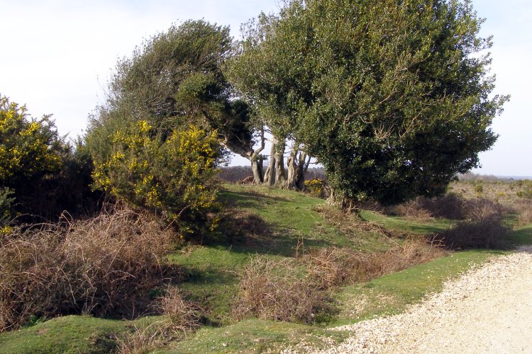
Longslade View tumulus submitted by JimChampion on 6th May 2007. March 2007. The gravel track on the right cuts across the east side of the bowl barrow, which is overgrown with holly and gorse bushes.
(View photo, vote or add a comment)
Log Text: None
Longlands barrow cemetery
Date Added: 19th Sep 2010
Site Type: Barrow Cemetery
Country: England (Dorset)
Visited: Yes on 26th Nov 2007

Longlands barrow cemetery submitted by JimChampion on 26th Nov 2007. Looking up from the Broadstone on the verge of the A35, towards one of the barrows in the Longlands cemetery. Sheep grazing. Rain.
(View photo, vote or add a comment)
Log Text: None
Longdown (New Forest) tumuli
Date Added: 19th Sep 2010
Site Type: Round Barrow(s)
Country: England (Hampshire)
Visited: Yes on 28th Mar 2005
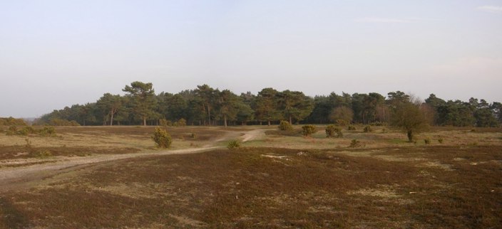
Longdown (New Forest) tumuli submitted by JimChampion on 28th Mar 2005. A composite image of the bowl barrow at grid ref SU36390822, with Ipley Inclosure in the background. According to Hampshire Treaures this barrow is 9m in diameter, 0.8m high, and has a large crater mutilation. Traces of a ditch are found on the south side (the far side in the picture), noticeable because no heather grows in the ditch.
(View photo, vote or add a comment)
Log Text: None
Longbarrow House
Date Added: 19th Sep 2010
Site Type: Long Barrow
Country: England (Hampshire)
Visited: Yes on 27th Jan 2008
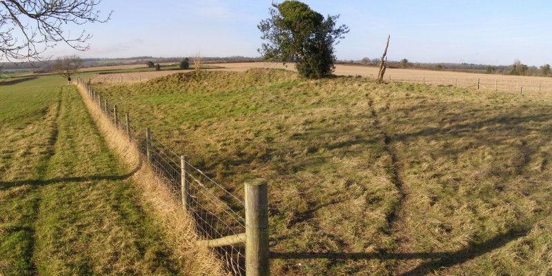
Longbarrow House submitted by JimChampion on 27th Jan 2008. Composite image of two photographs. The mutilated long barrow mound is to the right of the fence.
(View photo, vote or add a comment)
Log Text: None
Long Bredy Bank Barrow
Date Added: 19th Sep 2010
Site Type: Long Barrow
Country: England (Dorset)
Visited: Yes on 25th Apr 2005

Long Bredy Bank Barrow submitted by JimChampion on 25th Apr 2005. April 2005. A composite view of the bank barrow, looking south from the field gate (standing on the gatepost to get a better view). The curvature of the appropriately named Long Barrow Hill means that it is difficult to see the barrow from this close distance. The break in the bank is clearly visible, occurring about a third of the way along the barrows 200m length.
(View photo, vote or add a comment)
Log Text: None
Long Bredy 2
Date Added: 19th Sep 2010
Site Type: Long Barrow
Country: England (Dorset)
Visited: Yes on 27th Apr 2005

Long Bredy 2 submitted by JimChampion on 27th Apr 2005. April 2005. Looking north at the long barrow, with its larger eastern end nearer the camera. The earthwork behind the western end is a modern farm reservoir with a level signal sticking out of the top.
(View photo, vote or add a comment)
Log Text: None
Little Butser
Date Added: 19th Sep 2010
Site Type: Ancient Village or Settlement
Country: England (Hampshire)
Visited: Yes on 15th May 2005
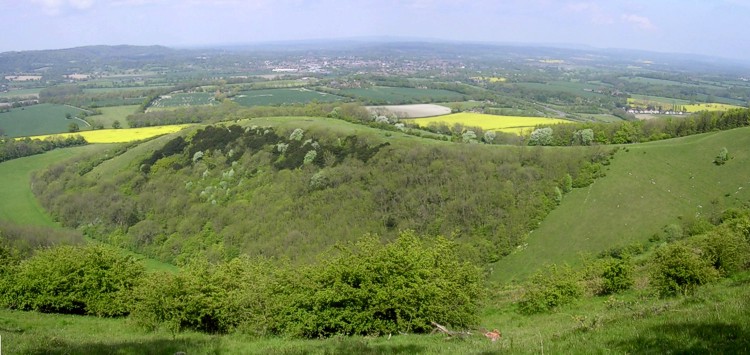
Little Butser submitted by JimChampion on 15th May 2005. May 2005. A panoramic view of Little Butser, looking east from the much higher neighbouring northerly spur of Butser Hill. Cross dykes separate the Little Butser spur from Butser Hill proper (to the right).
The town in the distance is Petersfield and the A3 runs very close by. You can't miss Butser Hill as you drive south on the A3: its the massive one with a mast on top.
(View photo, vote or add a comment)
Log Text: None
Lescudjack Castle
Date Added: 19th Sep 2010
Site Type: Hillfort
Country: England (Cornwall)
Visited: Yes on 31st Aug 2008
Lescudjack Castle submitted by JimChampion on 31st Aug 2008. From Trengwainton Carn there are splendid views across Mounts Bay. I took this photo, ostensibly of St Michael's Mount, using my camera's maximum zoom from the sunny but windy summit of Trengwainton Carn. Upon closer inspection later on, I found that I had inadvertently photographed Lescudjack Castle in Penzance - it lies roughly half way between The Mount and Trengwainton Carn. In this photo the hillfort is the area lit by direct sunlight in the centre left of the photo. For a version of this p...
(View photo, vote or add a comment)
Log Text: None
Laurences Barrow
Date Added: 19th Sep 2010
Site Type: Round Barrow(s)
Country: England (Hampshire)
Visited: Yes on 21st Jul 2007
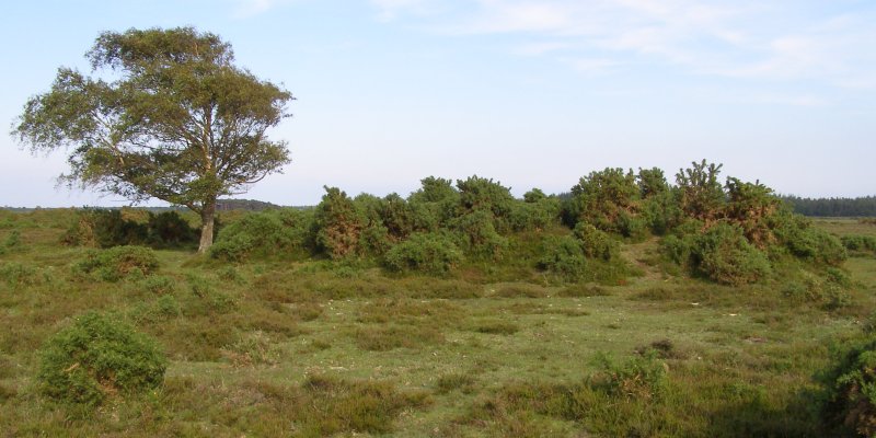
Laurences Barrow submitted by JimChampion on 21st Jul 2007. June 2007. Laurences Barrow, with the landmark windswept silver birch to the left of the mound. This view is looking from the north-west - in the distance (behind the silver birch tree) are the pines of Crockford Clump, and (to the right of the barrow) Norley Inclosure. The barrow mound itself is overgrown with gorse and has a slight hollow in its summit.
(View photo, vote or add a comment)
Log Text: None
Lanyon Quoit
Date Added: 19th Sep 2010
Site Type: Burial Chamber or Dolmen
Country: England (Cornwall)
Visited: Yes on 31st Dec 2004
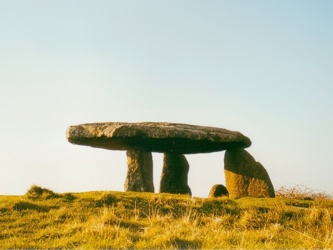
Lanyon Quoit submitted by JimChampion on 31st Dec 2004. August 2002. Late afternoon sunshine gives a pleasant colour to this picture-postcard quoit in West Penwith. The almost-horizontal capstone gives a very ordered feel to this monument: is this an artifact of the nineteenth-century rebuilding?
(View photo, vote or add a comment)
Log Text: None
Ladle Hill
Date Added: 19th Sep 2010
Site Type: Hillfort
Country: England (Hampshire)
Visited: Yes on 13th Jun 2005

Ladle Hill submitted by JimChampion on 13th Jun 2005. Looking west at the Ladle Hill bell barrow beside the Wayfarer's Walk path on the way up to the hillfort. This scheduled barrow is nearly 20m in diameter and up to 1.6m high. Apparently there was once a saucer barrow on the other side of this barrow, but no visible traces of it remain.
(View photo, vote or add a comment)
Log Text: None
Knowlton Rings
Date Added: 19th Sep 2010
Site Type: Henge
Country: England (Dorset)
Visited: Yes on 27th Feb 2005

Knowlton Rings submitted by JimChampion on 27th Feb 2005. February 2005. Composite image of Knowlton Henge under a heavy winter sky.
(View photo, vote or add a comment)
Log Text: None
Knowlton Great Barrow
Date Added: 19th Sep 2010
Site Type: Round Barrow(s)
Country: England (Dorset)
Visited: Yes on 9th Apr 2005
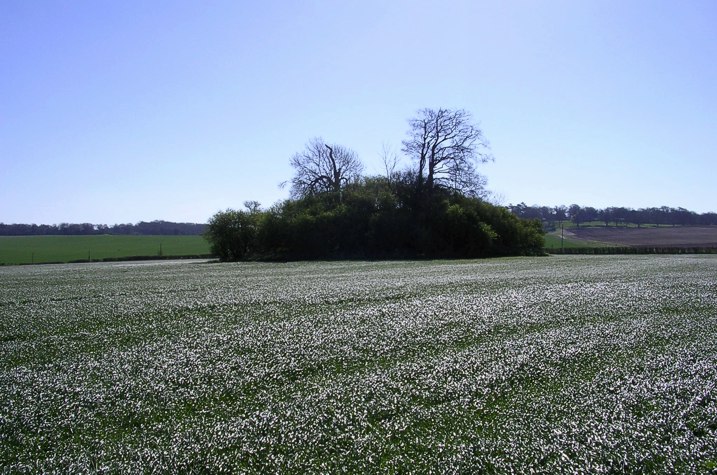
Knowlton Great Barrow submitted by JimChampion on 9th Apr 2005. April 2005. View of the great barrow from the centre of Knowlton Henge: a dark tree-covered island in a sea of shimmering young wheat. The agriculture in this field has completely removed any remains of the barrow's huge outer ditch (over 100m in diameter) but this can be seen as crop marks under suitable conditions.
(View photo, vote or add a comment)
Log Text: None
Knoll Down tumuli
Date Added: 19th Sep 2010
Site Type: Round Barrow(s)
Country: England (Hampshire)
Visited: Yes on 23rd Apr 2005
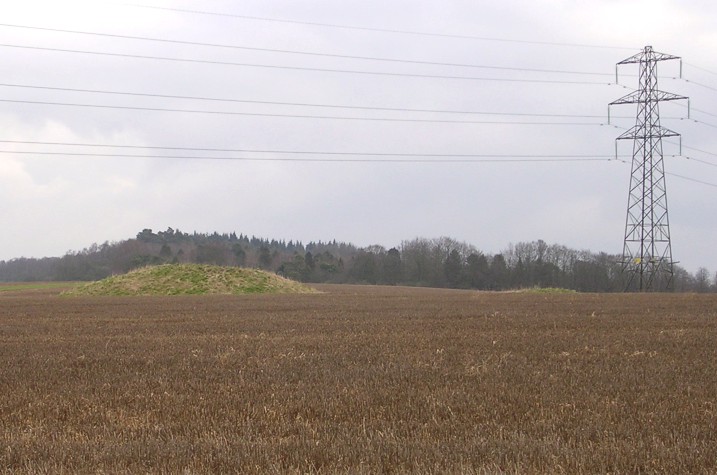
Knoll Down tumuli submitted by JimChampion on 23rd Apr 2005. February 2005. Two of the better preserved round barrows on Knoll Down with a picturesque pylon (?) in the background. The trees in the background cover Damerham Knoll and the site of Knoll Camp.
(View photo, vote or add a comment)
Log Text: None
Knaves Ash barrow
Date Added: 19th Sep 2010
Site Type: Round Barrow(s)
Country: England (Hampshire)
Visited: Yes on 17th Jul 2007
Knaves Ash barrow submitted by JimChampion on 17th Jul 2007. Close-up of the modern boundary stone set into the summit of the barrow mound. It has some letters and a date (19th century?) carved into it, but they have been weathered. There are several other boundary stones on the parish boundary between here and Lugden Barrow about 2 km to the south. The boundary is not just between the parishes of Burley and Ringwood, but also defines the old 'perambulation' of the Royal forest.
(View photo, vote or add a comment)
Log Text: None
Knap Barrow
Date Added: 19th Sep 2010
Site Type: Long Barrow
Country: England (Hampshire)
Visited: Yes on 27th Feb 2005

Knap Barrow submitted by JimChampion on 27th Feb 2005. February 2005. Longer but less prominent than the neighbouring Grans Barrow, the Knap barrow lies on a NW-SE axis. Viewed from the north-east in this composite image, on a cold winters day.
(View photo, vote or add a comment)
Log Text: None
Kingston Russell Stone 3
Date Added: 19th Sep 2010
Site Type: Standing Stone (Menhir)
Country: England (Dorset)
Visited: Yes on 25th Apr 2005
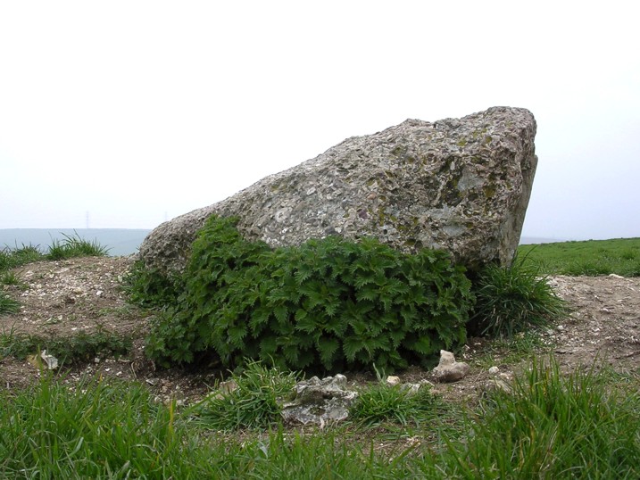
Kingston Russell Stone 3 submitted by JimChampion on 25th Apr 2005. April 2005. View of the east side of the conglomerate stone on top of the bowl barrow. The stone's dimensions are roughly 2x1x0.5m. The flinty barrow it stands on has been badly eroded by burrowing animals: from a distance the exposed chalk and soil is more visible than the stone itself.
(View photo, vote or add a comment)
Log Text: None
Kingston Russell Circle
Date Added: 19th Sep 2010
Site Type: Stone Circle
Country: England (Dorset)
Visited: Yes on 31st Dec 2004
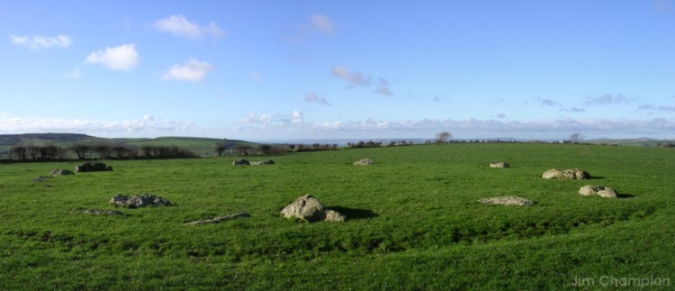
Kingston Russell Circle submitted by JimChampion on 31st Dec 2004. Boxing Day 2004. Composite image, taken shortly after noon looking south-west. The field is currently being used as pasture, which means that access is muddy but at least the circle is not lost in crops. Lyme bay can be seen in the distance, and Abbotsbury hill-fort to the left of this.
(View photo, vote or add a comment)
Log Text: None
Kingston Russell 2
Date Added: 19th Sep 2010
Site Type: Long Barrow
Country: England (Dorset)
Visited: Yes on 25th Apr 2005

Kingston Russell 2 submitted by JimChampion on 25th Apr 2005. April 2005. Looking southwest at the low profile of the bank barrow. The earthworks are quite obvious if you're there, but its very difficult to photograph (no contrast, only grass on grass). The taller SE end is visible on the left of the photo and the trees are behind the barrow (along the field's edge) rather than growing on it.
(View photo, vote or add a comment)
Log Text: None
Kingston Russell 1
Date Added: 19th Sep 2010
Site Type: Long Barrow
Country: England (Dorset)
Visited: Yes on 24th Apr 2005
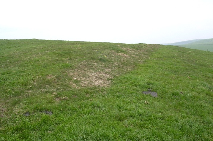
Kingston Russell 1 submitted by JimChampion on 24th Apr 2005. April 2005. Looking west along the remains of this neolithic long barrow, classed by some as a "bank barrow". It is in a sorry state, with an eroded bank cut through in several places by recent tracks and has barely noticeable ditches. The cows have left their usual mark.
(View photo, vote or add a comment)
Log Text: None
