Contributory members are able to log private notes and comments about each site
Sites Ermine has logged. View this log as a table or view the most recent logs from everyone
Martlesham Heath
Date Added: 22nd Jun 2016
Site Type: Round Barrow(s)
Country: England (Suffolk)
Visited: Yes on 29th Jun 2004

Martlesham Heath submitted by ermine on 29th Jun 2004. Grid Reference: TM256454
Type of site: Round Barrow
County : Suffolk
Nearest Town: Ipswich
Nearest Village: Martlesham Heath
Any web links relating to it: <a target=_top href="http://www.megalithia.com/sites/tm256454.html">Megalithia</a>
Barrow hidden in the woods on the left-hand side of the footpath leading from the industrial estate past the trailer park, as you come out of the woods and see the BT Earth station dishes to your right. A possible smaller site is ab...
(View photo, vote or add a comment)
Log Text: None
Mané Keriaval
Date Added: 22nd Jun 2016
Site Type: Passage Grave
Country: France (Bretagne:Morbihan (56))
Visited: Yes on 30th Jun 2004
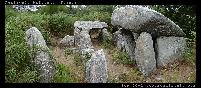
Mané Keriaval submitted by ermine on 30th Jun 2004. Morbihan, Carnac area
47.61535N 3.083378W WGS84 GPS onsite
You'd be forgiven for thinking this is a dolmen, and it is locally listed as such, but Burl sets you right. These stones were originally a passage grave with an earth mound on top
(View photo, vote or add a comment)
Log Text: None
Kerzerho Alignements
Date Added: 22nd Jun 2016
Site Type: Multiple Stone Rows / Avenue
Country: France (Bretagne:Morbihan (56))
Visited: Yes on 1st Jul 2004
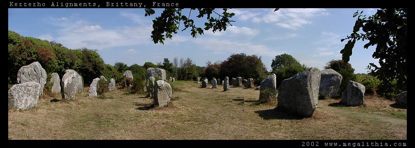
Kerzerho Alignements submitted by ermine on 1st Jul 2004. Kerzerho Alignments
Brittany, Morbihan
47.634690N 3.148402W GPS onsite
You can still walk among the stones at Kerzerho (in 2002 at east) which are near Carnac but not quite so busy. Head up the D781 to Erdeven. You can park nearby, and from there you can also take the path to the large stones of the Table du Sacrifice
(View photo, vote or add a comment)
Log Text: None
Kerloas Menhir
Date Added: 22nd Jun 2016
Site Type: Standing Stone (Menhir)
Country: France (Bretagne:Finistère (29))
Visited: Yes on 14th Jul 2004
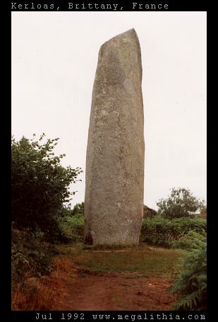
Kerloas menhir submitted by ermine on 14th Jul 2004. This is the tallest standing stone in Europe, according to Aubrey Burl, and would be even taller had it not been hit by lightning 200 years ago. It stands today at 9.5 m above ground.
(View photo, vote or add a comment)
Log Text: None
Le Petit Ménec
Date Added: 22nd Jun 2016
Site Type: Multiple Stone Rows / Avenue
Country: France (Bretagne:Morbihan (56))
Visited: Yes on 6th Aug 2004
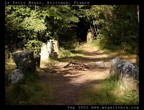
Le Petit Ménec submitted by ermine on 6th Aug 2004. Confusingly, Petit-Menéc is in fact at the opposite, eastern end of the alignments to le Menéc village at the western end. You need to turn left onto the D186 main road after continuing from Kerlescan. After about 250m turn right into a minor road going past a forest, there is a clearing where you can park after about 400m. The menhirs are in the forest on your right, arranged in a gentle curve. You don't get the same clear overview of the alignments since the view is obscured by the trees, bu...
(View photo, vote or add a comment)
Log Text: None
Menhir de Goulvars
Date Added: 22nd Jun 2016
Site Type: Standing Stone (Menhir)
Country: France (Bretagne:Morbihan (56))
Visited: Yes on 8th Aug 2004

Menhir de Goulvars submitted by ermine on 8th Aug 2004. This 4m tall granite menhir stands near the Conguel campsite and the Quiberon aerodrome - it extends another 1m into the ground, according to the information board
(View photo, vote or add a comment)
Log Text: None
Toller Porcorum
Date Added: 22nd Jun 2016
Site Type: Standing Stones
Country: England (Dorset)
Visited: Yes on 26th Sep 2004

Toller Porcorum submitted by ermine on 26th Sep 2004. SY561979, St Andrew & St Peter
(detail of stones)
Part of the church wall collapsed a few years back, and two small stones were revealed. These have now been moved to either side of the main gate.
(View photo, vote or add a comment)
Log Text: None
Sutton Hoo
Date Added: 22nd Jun 2016
Site Type: Artificial Mound
Country: England (Suffolk)
Visited: Yes on 30th Sep 2004

Sutton Hoo submitted by ermine on 30th Sep 2004. The Great Gold Buckle
(View photo, vote or add a comment)
Log Text: None
Thornborough (Bucks)
Date Added: 22nd Jun 2016
Site Type: Barrow Cemetery
Country: England (Buckinghamshire)
Visited: Yes on 1st Oct 2004

Thornborough (Bucks) submitted by ermine on 1st Oct 2004. This is Thornborough Bucks, not Yorks - two large Saxon barrows
Thornborough (Bucks)SP732333
more info
(View photo, vote or add a comment)
Log Text: None
Devil's Dyke, Cambridgeshire
Date Added: 22nd Jun 2016
Site Type: Misc. Earthwork
Country: England (Cambridgeshire)
Visited: Yes on 4th Oct 2004

Devil's Dyke, Cambridgeshire submitted by ermine on 4th Oct 2004. Devil's Dyke, Cambridgeshire from approx TL580646 looking south-east
Massive Anglian defence that stretched from an area of dense woodland to one of marsh. The dyke is nearly 8 miles long and crosses a chalk ridge. At either end were impassable forests and fens. It was built to defend the East Angles by cutting off the Icknield Way.
(View photo, vote or add a comment)
Log Text: None
Chalice Well
Date Added: 22nd Jun 2016
Site Type: Holy Well or Sacred Spring
Country: England (Somerset)
Visited: Yes on 4th Oct 2004

Chalice Well submitted by ermine on 4th Oct 2004. If you've missed the opening times of Chalice Well or you just want to sample the water you can get some from this outlet. It is in the lane to the right of the Chalice Well main entrance and is fed from the overflow from the well
(View photo, vote or add a comment)
Log Text: None
Mutlow Hill
Date Added: 22nd Jun 2016
Site Type: Round Barrow(s)
Country: England (Cambridgeshire)
Visited: Yes on 4th Oct 2004

Mutlow Hill submitted by ermine on 4th Oct 2004. Mutlow Hill, on Fleam Dyke. Looking southeast
The Saxons often used round barrows for secondary burials or, as here, as "mutlows". These were meeting places (mut= meet and low is from hlaw - a sacred mound) At the local mutlow, local matters would be discussed, laws proclaimed and disputes settled. Sometimes punishments or executions would take place and many mutlows retained this last feature and became gallows hills.
(View photo, vote or add a comment)
Log Text: None
Mutlow Hill
Date Added: 22nd Jun 2016
Site Type: Round Barrow(s)
Country: England (Essex)
Visited: Yes on 4th Oct 2004

Mutlow Hill submitted by ermine on 4th Oct 2004. Mutlow Hill, on Fleam Dyke. Looking southeast
The Saxons often used round barrows for secondary burials or, as here, as "mutlows". These were meeting places (mut= meet and low is from hlaw - a sacred mound) At the local mutlow, local matters would be discussed, laws proclaimed and disputes settled. Sometimes punishments or executions would take place and many mutlows retained this last feature and became gallows hills.
(View photo, vote or add a comment)
Log Text: None
Lady Well, Woolpit
Date Added: 22nd Jun 2016
Site Type: Holy Well or Sacred Spring
Country: England (Suffolk)
Visited: Yes on 4th Oct 2004
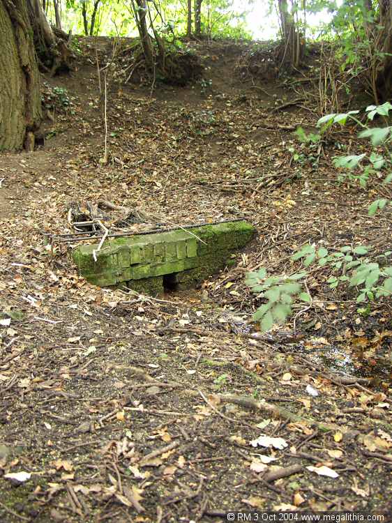
Lady Well, Woolpit submitted by ermine on 4th Oct 2004. The actual site of the well is difficult to find, as it feeds a moat so there is a lot of water about. This brick enclosure is the well itself.
(View photo, vote or add a comment)
Log Text: None
Iken Saxon Cross
Date Added: 22nd Jun 2016
Site Type: Ancient Cross
Country: England (Suffolk)
Visited: Yes on 12th Oct 2004

Iken Saxon Cross submitted by ermine on 12th Oct 2004. Iken Saxon Cross
Erected c 870-1000, and incorporated into the fabric of St Botolph's church in the 15th century. This Saxon cross shaft remained hidden until the 1977 restoration of the church following an earlier fire.
NGR TM412566
(View photo, vote or add a comment)
Log Text: None
Kedington Cross
Date Added: 22nd Jun 2016
Site Type: Ancient Cross
Country: England (Suffolk)
Visited: Yes on 16th Oct 2004
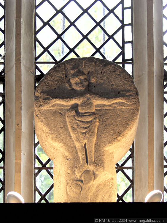
Kedington Cross submitted by ermine on 16th Oct 2004. Close-up of the Saxon Cross
St Peter & St Paul, Kedington, Suffolk
TL705470
(View photo, vote or add a comment)
Log Text: None
Woolpit Cross
Date Added: 22nd Jun 2016
Site Type: Ancient Cross
Country: England (Suffolk)
Visited: Yes on 16th Oct 2004
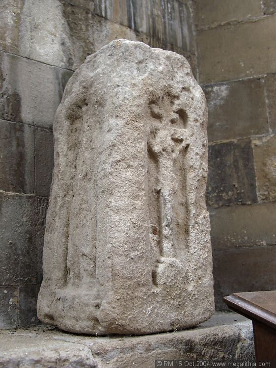
Woolpit Cross submitted by ermine on 16th Oct 2004. This is described as part of a Saxon cross in the guide to St Mary, Woolpit church.
TL974625
(View photo, vote or add a comment)
Log Text: None
St Augustine's Well (Cerne Abbas)
Date Added: 22nd Jun 2016
Site Type: Holy Well or Sacred Spring
Country: England (Dorset)
Visited: Yes on 9th Jan 2005
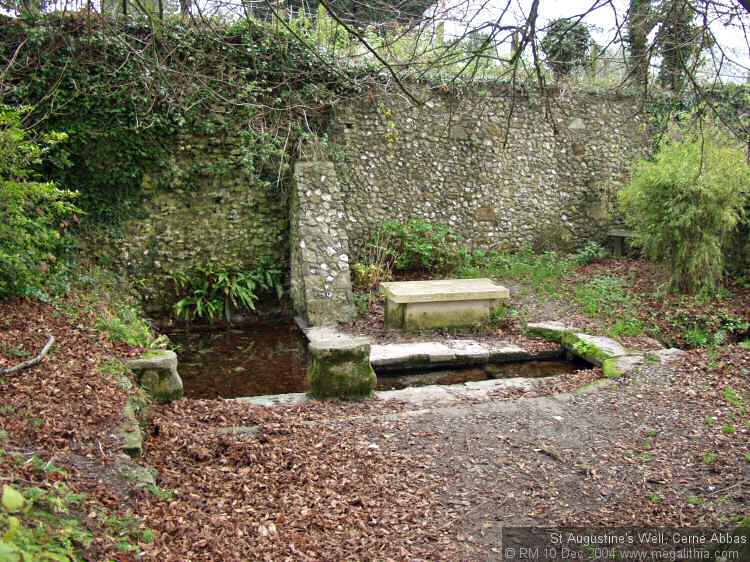
St Augustine's Well (Cerne Abbas) submitted by ermine on 9th Jan 2005. St Augustine's well in Cerne Abbas is a tranquil place. Walk up Abbey Street and turn into the graveyard - the well is a couple of hundred yards alond the track. The flow is good and was the village's source of drinking water in the last century.
The Abbey nearby is also worth a visit, as well as the nearby Giant hillfigure.
(View photo, vote or add a comment)
Log Text: None
Kersey Puddingstone
Date Added: 22nd Jun 2016
Site Type: Natural Stone / Erratic / Other Natural Feature
Country: England (Suffolk)
Visited: Yes on 15th Nov 2005

Kersey Puddingstone submitted by ermine on 15th Nov 2005. This is the overview of where this stone is, half buried in the pavement by the footbridge over the watersplash. It is on the left if you are standing on the bank overlooking the watersplash up the hill towards the church.
Don't miss the other stone which is about 200 metres away on the other side of the road erupting from the pavement near some steps
(View photo, vote or add a comment)
Log Text: None
Whitestreet Green
Date Added: 22nd Jun 2016
Site Type: Natural Stone / Erratic / Other Natural Feature
Country: England (Suffolk)
Visited: Yes on 26th Oct 2015
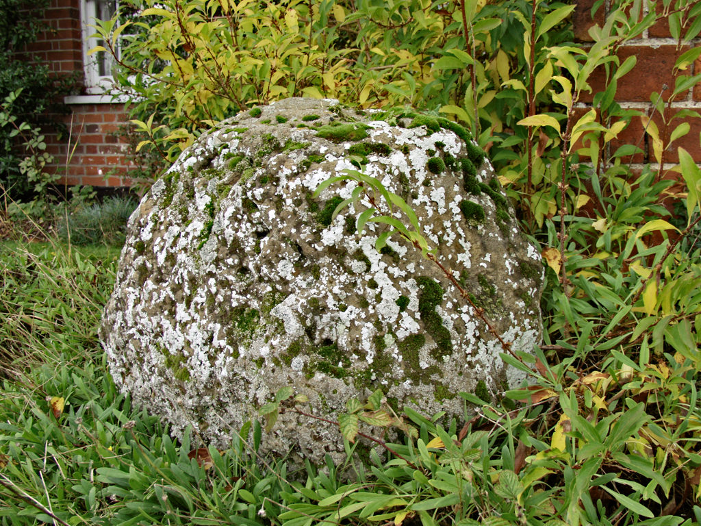
Whitestreet Green submitted by ermine on 26th Oct 2015. This stone/boulder is about 1m high on Whitestreet Green, potentiall on the puddingstone trail
(View photo, vote or add a comment)
Log Text: None
