


Contributory members are able to log private notes and comments about each site
Sites Enki has logged. View this log as a table or view the most recent logs from everyone
Chatton 1a
Date Added: 17th Oct 2020
Site Type: Rock Art
Country: England (Northumberland)
Visited: Would like to visit

Chatton 1a submitted by SolarMegalith on 18th Mar 2013. Cup-and-ring mark on Chatton 1a panel shining in the sun after the rain (photo taken on March 2013).
(View photo, vote or add a comment)
Ravenswood Avenue
Date Added: 11th Aug 2019
Site Type: Standing Stone (Menhir)
Country: Scotland (Midlothian)
Visited: Yes on 11th Aug 2019. My rating: Condition 3 Ambience 3 Access 5
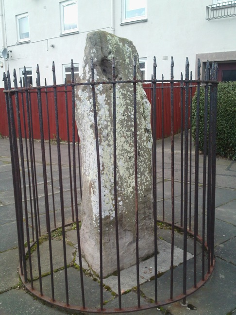
Ravenswood Avenue submitted by crannog on 27th Feb 2012. Closer look.
(View photo, vote or add a comment)
Log Text: A pleasant walk through the housing estate (after visiting the Cat Stane at Inch) brought us to this sad menhir, cut off from its surroundings by an enclosing metal cage. Again, not in its original position, although I was able to dowse the likely location of that in the road.
The metal railings effectively cut off any decent energy lines; I was only able to dowse one line running through it diagonally.
Cat Stane (Inch)
Date Added: 11th Aug 2019
Site Type: Standing Stone (Menhir)
Country: Scotland (Midlothian)
Visited: Yes on 11th Aug 2019. My rating: Condition 5 Ambience 3 Access 5
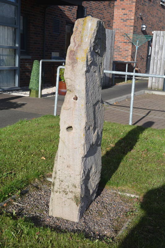
Cat Stane (Inch) submitted by Anne T on 23rd Feb 2017. First view of the Cat Stane from the car park of (the rear?) of Inch View Care Home for the Elderly. This stone is recorded as Canmore site 52552.
(View photo, vote or add a comment)
Log Text: Despite previous reports stating that permission is required to visit this stone, we went on a Sunday and the place seemed very quiet, so we just walked in without challenge. The stone is right outside the door to the nursing home and close to windows, so I imagine that on a weekday you might be questioned about visiting.
It's obviously had a chequered career as it shows several holes where it has been re-purposed as a gatepost, and it's not in its original position. Yet having said that, it's quite a nice bit of stone and still retains some sense of atmosphere about it. I dowsed 3 x energy lines running through it, one in the direction of Arthur's Seat.
Balgarthno
Date Added: 17th Feb 2019
Site Type: Stone Circle
Country: Scotland (Angus)
Visited: Yes on 16th Feb 2019. My rating: Condition 2 Ambience 3 Access 4

Balgarthno submitted by crowfoot on 29th Jul 2007. Balgarthno April 2007, it's now fenced off and tidied up quite a bit. looked after by Dundee City Council.
(View photo, vote or add a comment)
Log Text: I was confused as this circle is described as a recumbent circle, but it has nothing in common with the recumbent style as far as I can see, and the Canmore entry makes this clear..
Access is pretty easy from the road, there is a track that you could get a wheelchair along, but the final 20m or so is over grass. There is a fence with a gate to allow access to the circle, although the gate has not been installed properly and required some manipulation to get open.
Condition is reasonable although there is only one stone remaining upright. Ambience is pretty minimal and not helped by the overhead power lines nearby.
Westfield Farm Refuge Stone
Date Added: 10th Feb 2019
Site Type: Early Christian Sculptured Stone
Country: Scotland (West Lothian)
Visited: Yes on 10th Feb 2019. My rating: Condition 5 Ambience 4 Access 4
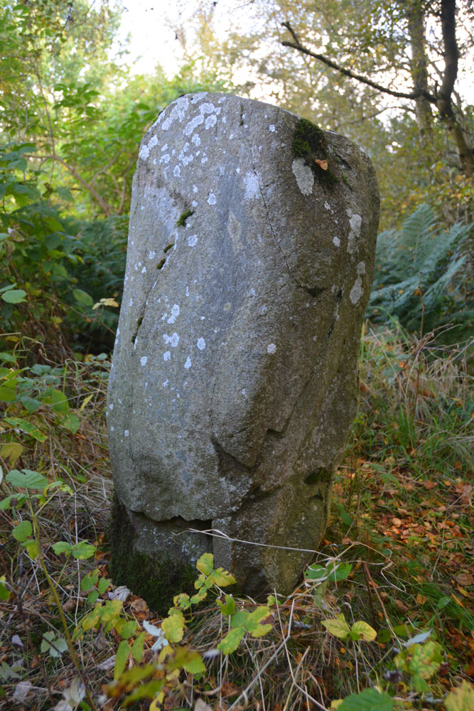
Westfield Farm Refuge Stone submitted by Anne T on 11th Oct 2017. One of the other faces of the stone, where it shows slight traces of damage, presumably from having been toppled and re-erected. If the 1998 excavation report from Historic Scotland is correct, this stone may be prehistoric and associated with a larger prehistoric site, maybe having been reused as a Refuge Stone after the establishment of Torphichen Preceptory.
(View photo, vote or add a comment)
Log Text: Westfield Farm refuge stone is somewhat similar to the sanctuary stone in the churchyard at Torphichen, being a bit narrower at the base and it clearly appears to have been worked on at least two sides. It's considerably larger however.
There is faint evidence of some tantalising scratchings that could possibly (with some imagination) be Ogham writing on the south face but are probably just foliage marks.
Access was easy at this time of year as the shrubbery is pretty minimal, and I had no trouble finding the stone. There's a fairly clear path up the mound from the track that I took, discovering on the way back down that I'd missed the stairs that are now very overgrown.
Brithdir Mawr stone circle
Date Added: 1st Oct 2018
Site Type: Modern Stone Circle etc
Country: Wales (Pembrokeshire)
Visited: Yes on 5th Sep 2003

Brithdir Mawr stone circle submitted by Enki on 5th Sep 2003. Another shot of Brithdir Mawr circle, grid ref SN 071379, looking SE towards Pentre Ifan.
(View photo, vote or add a comment)
Log Text: For an account of the raising of this circle, see: https://geomancygroup.org/sacred-space/stone-circles/brithdir-mawr/
Easthill
Date Added: 1st Oct 2018
Site Type: Stone Circle
Country: Scotland (Dumfries and Galloway)
Visited: Yes on 30th Sep 2018. My rating: Condition 3 Ambience 4 Access 3

Easthill Stone Circle submitted by HardcoreDave on 27th Apr 2005. Easthill
(View photo, vote or add a comment)
Log Text: A bit of a walk (and this might not be the best route if bracken is high!)- we parked in lane beside farm buildings opposite South Castlehill and followed track up the hill to a ruined cottage and 2 barns. Bear right and continue following track uphill. Once you clear the trees, pass 2 thorn trees and turn right where there is a line of some low rocks. Keep going in that direction through bracken, crossing another track until you come to a second track. Follow this to the right towards the ridge of the hill and the circle is just to the right.
The Tron
Date Added: 24th Jul 2017
Site Type: Modern Stone Circle etc
Country: Scotland (Angus)
Visited: Yes on 22nd Jul 2017. My rating: Condition 4 Ambience 3 Access 4

The Tron submitted by golux on 20th Feb 2014. RCAHMS say "The tron, to which jougs are still attached, stands in the centre of Meikleour. T Hunter 1883 The tron is a rusticated obelisk with a hole near its pointed top, surmounted by a tall spike with a weather vane. The jougs are attached to its S face."
I say "weird, even creepy".
(View photo, vote or add a comment)
Log Text: A strangely poignant atmosphere pervades this solitary stone, left isolated from the rest of the village square by a high hedge.
There is reasonably easy access by walking a short way up the estate side road past the fence, then cutting back through some long grass. The Tron is protected by a wooden fence rail. The 'jougs' are a chain and manacle attached to one side, and a hole through the top of the stone is where the balance bar for the tron would have been.
Colen
Date Added: 24th Jul 2017
Site Type: Stone Circle
Country: Scotland (Perth and Kinross)
Visited: Yes on 22nd Jul 2017. My rating: Condition 2 Access 3

The Colen Circle submitted by Nick on 5th Nov 2002. Leave Scone by the A93 heading north, take the minor road towards Stormontfield, pass through it and keep heading north. About a mile north, the road bends to the right by a group of trees. Park at the right side of the road and look up the hill - you will see a sign. Walk back down the road to the stile, and follow the signs to the top of the hill. On a clear day, the view from the stones is magnificent. It has been described thus : The poorly-preserved remains of a stone circle are situat...
(View photo, vote or add a comment)
Log Text: Circle was very overgrown, could only really make out the large stone and the cup-marked fallen stone next to it. With some more thrashing through the undergrowth I found another 3 or 4 smaller fallen stones, but it was heavy going. Lovely view though.
Spaceguard Centre
Date Added: 2nd May 2017
Site Type: Modern Stone Circle etc
Country: Wales (Powys)
Visited: Yes on 22nd Apr 2017. My rating: Condition 3 Access 4

Spaceguard Centre submitted by TimPrevett on 7th Sep 2006. Looking NE across the NW arc, with Observatory buildings to the rear.
(View photo, vote or add a comment)
Log Text: Access to the site is very easy by car, the circle is right beside the car park. However the circle itself is very overgrown and neglected with some trees within and very uneven ground making walking difficult.
Several stones are literally disintegrating - they seem to be unweathered chalk -and it is doubtful that they will survive another 20 years. One in particular was just a stump amidst a pile of fragments.
The Spaceguard curator is absurdly, incredibly rude. He doesn't like the circle, doesn't see the point of having an astronomically-aligned stone circle, and is actively trying to have it removed so that he can have "a proper garden". We tried to have a civilised conversation about the merits of astronomically-aligned sites but were so dumbfounded by his manner that we had to leave before things escalated. A sad end to an otherwise lovely day.
Breemie Stones
Date Added: 8th Feb 2017
Site Type: Modern Stone Circle etc
Country: Scotland (Aberdeenshire)
Visited: Yes on 1st Jan 2016. My rating: Condition 5 Ambience 5 Access 4

Breemie Stones submitted by sacredway on 23rd Apr 2007. Looking over the granite recumbent and flankers towards the Barmekin Hill at Echt (hill fort remains on top of the Barmekin hill). Note the shape of the recumbent mimicks the shape of the Barmekin Hill and the distant Hill of Fare. It was aligned to this hill on its SW axis. The left flanker is about 6.5 feet tall.
(View photo, vote or add a comment)
Log Text: Open access, park behind BA Country Stores and walk up the hill to the labyrinth and stones. For more info on the labyrinth, see: http://geomancygroup.org/sacred-space/labyrinths/breemie/
Brainport Bay Standing stones and Alignment
Date Added: 7th Sep 2016
Site Type: Standing Stone (Menhir)
Country: Scotland (Argyll)
Visited: Yes on 7th Jun 2004

Brainport Bay Standing stones and Alignment submitted by Enki on 7th Jun 2004. Midsummer sunrise alignment of two stones and viewing platforms, recently discovered.
(View photo, vote or add a comment)
Log Text: None
Cothiemuir Wood
Date Added: 7th Sep 2016
Site Type: Stone Circle
Country: Scotland (Aberdeenshire)
Visited: Yes on 7th Apr 2005

Cothiemuir Wood submitted by Enki on 7th Apr 2005. Cothiemuire Wood showing the kist burial in the centre of the circle
(View photo, vote or add a comment)
Log Text: None
St. Kennera's Cross
Date Added: 7th Sep 2016
Site Type: Ancient Cross
Country: Scotland (Dumfries and Galloway)
Visited: Yes on 18th Jan 2016
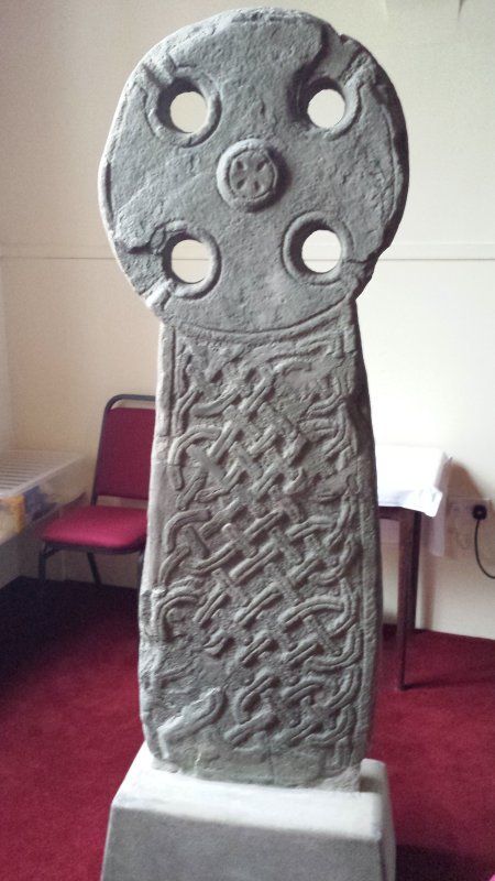
St. Kennera's Cross submitted by Enki on 18th Jan 2016. St. Kennera's Cross inside the parish church in Kirkinner.
(View photo, vote or add a comment)
Log Text: None
St. Conal's Well
Date Added: 7th Sep 2016
Site Type: Holy Well or Sacred Spring
Country: Scotland (Dumfries and Galloway)
Visited: Yes on 5th Sep 2016

St. Conal's Well submitted by Enki on 5th Sep 2016. St. Conal/Connel's Well near Kirkconnel
(View photo, vote or add a comment)
Log Text: None
St. Conal's stone
Date Added: 7th Sep 2016
Site Type: Rock Art
Country: Scotland (Dumfries and Galloway)
Visited: Yes on 5th Sep 2016
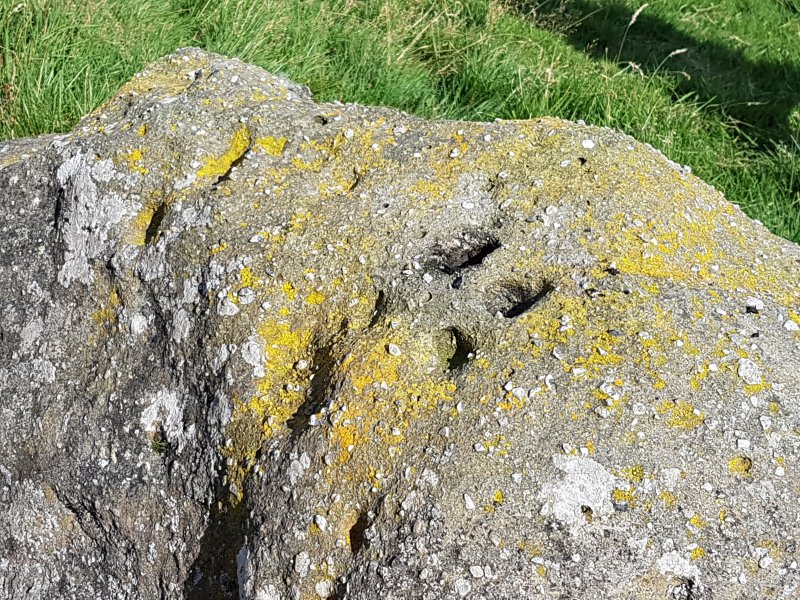
St. Conal's stone submitted by Enki on 5th Sep 2016. St. Conal's Stone - close up of cup-marks on top
(View photo, vote or add a comment)
Log Text: None
Annathill Farm
Date Added: 19th Jan 2016
Site Type: Modern Stone Circle etc
Country: Scotland (North Lanarkshire)
Visited: Yes on 19th Jan 2016. My rating: Condition 3 Ambience 3 Access 3
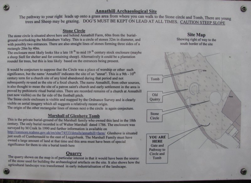
Annathill Farm submitted by Enki on 19th Jan 2016. Annathill farm, information board
(View photo, vote or add a comment)
Log Text: I had not heard of this site until seeing it on the Megalithic Portal Google Earth file, so went to investigate. I think it is erroneously listed here as an ancient stone circle, the stones are small and on the whole adjactent to each other giving it more of the feel of an enclosure, possibly 18th C. or thereabouts, and it is listed as such on Canmore. The low bank is easily visible and marked by trees on the south-east quadrant by a pond. The stones are small and many are completely overgrown; the tallest is about 3 foot.
There is a stone row leading off in a roughly northerly direction towards the tomb, with an odd rectangular structure between the enclosure and the tomb - a possible cairn maybe?
Access is relatively straightforward- at the western end of Mollinsburn there is a farm track leading up the hill that soon splits into two parallel tracks that run side by side for about 3/4 mile, The right-hand one continues for another half mile or so, becoming a footpath that leads into Annathill wood. Eventually it comes to a gate, and another gate immediately through this on the left leads to a steep path that curves up to the hill summit where you will find the enclosure and the walled tomb of Walter Marshall. There is a small informational board by the gate and a signpost at the top of the path.
Ōyu
Date Added: 19th Jan 2016
Site Type: Stone Circle
Country: Japan (Honshū)
Visited: Yes on 1st Jul 2015. My rating: Condition 4 Ambience 5 Access 4
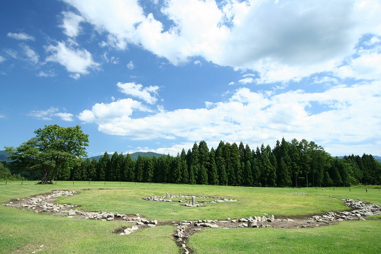
Ōyu submitted by Aska on 6th Feb 2008. The Nonakadō circle (east)
(View photo, vote or add a comment)
Log Text: An excellent visitor centre with good exhibits of Jomon artefacts and cultural displays sets the scene well for these two circles, although there is a distinct lack of English information. They did produce a small brochure with some bits in English when asked.
Clearly a large community lived here, as there are several other structures on the site - several hut circles, aligned posts, other buildings, cist burials, stone rows and a causeway connecting the two main circles, which are located on either side of the road.
Acces to the inside of the circles themselves is prohibited, but the Manza (NW) circle has a viewing platform next to the circle, and there are also thatched shelters constructed on hut foundations adjacent to the circle, which provide welcome relief from the hot sun in summer.
The proximity of the huts to the circle suggest that this one played a large part in everyday community life; the Nonakado circle over the road seems less disturbed in that regard. The Nonakado site has some smaller stone remains nearby, including what might be small burial cairns and a stone row.
The main axis of the two sites is aligned to midwinter sunrise and midsummer sunset; a suggestive alignment of three stones in the Nonakado circle may indicate equinox sunrise.
Komakino
Date Added: 19th Jan 2016
Site Type: Stone Circle
Country: Japan (Honshū)
Visited: Yes on 1st Jul 2015. My rating: Condition 4 Ambience 4 Access 4

Komakino submitted by Aska on 20th Jul 2009. Site in Honshu
(View photo, vote or add a comment)
Log Text: A well-restored Jomon site with easy footpath access from the small visitor centre. The road up the hill to the site is another story however!
A slice has been left unexcavated to allow access to the centre of the circle, which is otherwise forbidden. There is a viewing platform to the west of the circle providing a good overview of the circle. The outer rim of the circle exhibits the best example of the characteristic Jomon layering construction that has become known as 'Komakino style' after this site.
Surrounding trees prevent observing of any astronomical alignments, although the circle does indicate an alignment to the summer solstice sunrise.
The ambience is overall very peaceful, especially in the trees on the east side where the cist burial mounds are located.
Murthly
Date Added: 26th Aug 2014
Site Type: Stone Circle
Country: Scotland (Perth and Kinross)
Visited: Would like to visit

Murthly submitted by Hilary on 30th Jan 2012. When I visited in January 2012 the circle had been adopted by local people and now looks well cared for. A public pathway has been provided by the estate developer, so access is no longer a problem.
(View photo, vote or add a comment)