Contributory members are able to log private notes and comments about each site
Sites Anne T has logged on trip number: 105 (View all trips)
View this log as a table or view the most recent logs from everyone
Duns Mercat Cross
Trip No.105 Entry No.1 Date Added: 4th Nov 2018
Site Type: Ancient Cross
Country: Scotland (Scottish Borders)
Visited: Yes on 27th Oct 2018. My rating: Condition 3 Ambience 3 Access 5
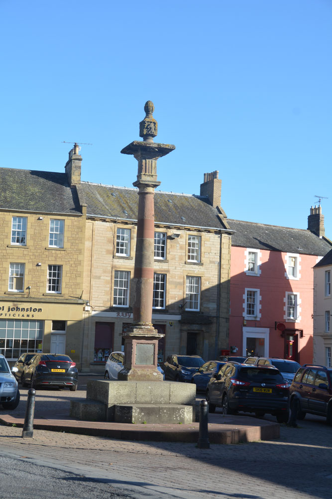
Duns Mercat Cross submitted by Anne T on 4th Nov 2018. The current market cross, moved to its present location in 1897.
(View photo, vote or add a comment)
Log Text: Duns Mercat Cross: Having set off after a snow storm this morning, we stopped off in Duns just after 12 noon for coffee and a scone.
We went to the café we went to when we were here last (some 3-4 years ago), only to find the café open but no-one in, despite many cars in the town. Parking just round the corner from the market square, I realised that there was a market cross which I don’t think I’d photographed before. Whilst the base was ‘modern’ the top appears old.
The café had changed hands, reverting to the original owner, who admitted to being 76 years old and having run a gallery in Harrogate. “We don’t do lunches” we were told. By this time we were cold and hungry so opted for hot scones and tea. A great selection of very reasonably priced antiques to browse round, too, although the only thing I would really have liked to buy wasn't for sale!
The plaque on the cross base reads: “The Mercat Cross of Duns originally stood on the site of the present town hall and was removed when it was rebuilt in 1820. It was re-erected by Andrew Smith Esqr. of Whitchester AD 1897.”
Whiteadder Reservoir
Trip No.105 Entry No.2 Date Added: 4th Nov 2018
Site Type: Cairn
Country: Scotland (East Lothian)
Visited: Yes on 27th Oct 2018. My rating: Condition 2 Ambience 4 Access 4

Whiteadder Reservoir submitted by Anne T on 4th Nov 2018. This appears to be all that is left of the stone setting and cairn, although the grass and bracken were mid-calf height, so other stones could have been hidden underneath. The cairn is easily identifiable, as it stands above the surrounding ground level, with a stone emerging from one side of the centre of the mound. This view is looking west north west over the cairn.
(View photo, vote or add a comment)
Log Text: Whiteadder Reservoir cairn and stone setting: We parked at NT 64304 64291 and walked along the first part of the Herring Road onto the land high above Whiteadder Reservoir with the GPS to find this stone setting and enclosure, with the cold winds whipping around our ears. From what I'd read on Canmore, I expected something a little different from what we found on the ground, which was in effect a cairn.
Despite walking round the area looking for these stones, and trying to feel for stones under our feet, we only found what looked like a cairn with one stone sticking up out of it. It is the same area as that given by Canmore. A 1971 entry says the enclosure has been completely destroyed, except "three small stones exist." As the grass and heather was calf deep, it was probable the stones were hidden underneath.
Looking at the map on the Canmore record, the cairn we spotted is in the correct location for the stones, with the enclosure about 20m to the south, identifiable as there is a flat, circular area in the bracken. Beautiful views over the reservoir.
The sign on the ‘public path’ signpost reads: Heritage Path, Herring Road. This old path is named because it was used by the fishwives of Dunbar when carrying massive creels of herring to market in Lauder. This track was one of many different routes that were used by the fishwives over the centuries as paths became eroded and were replaced.” And “Herring Road to Dunbar, 12.5miles via Dunbar Common and Halls”.
Packman's Grave (Whiteadder Reservoir)
Trip No.105 Entry No.3 Date Added: 4th Nov 2018
Site Type: Stone Row / Alignment
Country: Scotland (East Lothian)
Visited: Couldn't find
Log Text: Packman's Grave, Whiteadder Reservoir: Despite having the grid reference, we were unable to find anything at this site, which was disappointing. We did find something remarkably similar at NT 62814 64541 - five stones in a kite-;ike shape, not far to the south west of the Mayshield Stone Setting.
Hanging Stanes (Braid Road)
Trip No.105 Entry No.3 Date Added: 5th Nov 2018
Site Type: Marker Stone
Country: Scotland (Midlothian)
Visited: Yes on 28th Oct 2018. My rating: Condition 2 Ambience 3 Access 5
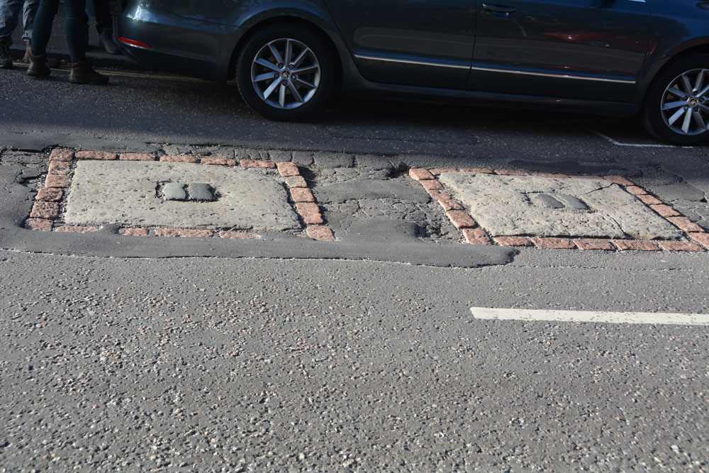
Hanging Stanes (Braid Road) submitted by Anne T on 5th Nov 2018. The two gallow bases are embedded in the road surface. I originally thought this site was associated with witches, but was the site of the execution of the last two highwaymen in Scotland. We picked this site up from the Ancient Stones website, and as it was very close to the Buckstane, thought we'd take a look.
(View photo, vote or add a comment)
Log Text: The Hanging Stanes: Having spotted this site on the Ancient Stones website, and with them being just down the road from the Buck Stane, we decided to pay this site a visit on the way into Edinburgh City Centre. I don't know why I thought these were originally associated with witches, but found out otherwise during the visit.
We pulled up next to the junction of Braid Road and Comiston Road, as per the directions on the Ancient Stones, only to find some people from the house immediately next to it were leaving and getting into their car. The older gentleman from the house asked me if we’d seen the plaque on the street and told me around 30 people each day come to see these stones.
The plaque in the pavement reads: “The Hanging Stanes. Thomas Kelly and Henry O’R eil, the last two highwaymen in Scotland to be executed, were hanged in public on 25th January 1616, from the gallows erected on the two stanes still visible on the spot, which was where the robbery took place. Paid for by public subscription. 1995.”
I risked getting run over to avoid my shadow falling across the stones, but they were half in shade and half in the sun, so the photos weren’t great. With these stones being sited on the slope of a hill with views over the city centre, without the traffic and the people around, this would have been a very atmospheric and enigmatic place.
Mayshiel Stone Circle
Trip No.105 Entry No.4 Date Added: 4th Nov 2018
Site Type: Stone Circle
Country: Scotland (East Lothian)
Visited: Yes on 27th Oct 2018. My rating: Condition 3 Ambience 4 Access 4
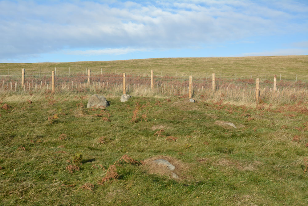
Mayshiel Stone Circle submitted by Anne T on 4th Nov 2018. The Mayshiel stones from the south. At the top of the slope, there were five stones which protruded out of the grass. Looking more closely, there were some further down-slope, largely hidden by turf, but nevertheless still part of this stone setting.
(View photo, vote or add a comment)
Log Text: Mayshiel Stone Setting: Whilst we were here to see the stones at NT 6298 6465, the first thing I spotted was a huge pile of clearance stones just up the hill in a field just north of the B6355. The second was what looked like a standing stone at the edge of the field at NT 62924 64612. On closer look, this may have been a large field clearance stone, which sits on top of other small boulders.
The stones at Mayshiel are very close to the road. At first glance, there are only three, but the longer we looked, more became evident.
There were also another group of stones at approx. NT 62814 64541 which had the appearance of a cist, but the stones forming the longer sides were very large. These stones may have just been a natural outcrop. One of the stones had been broken and the split off bit was lying half way along the northern end of the group.
Looking at the latter group of stones at home, they were similar in description to Canmore’s description of the Packman’s Grave (above).
At first glance, an insignificant site, but the more we walked round, the better it became, and it was well worth stopping off to look at this.
Rood Well
Trip No.105 Entry No.5 Date Added: 5th Nov 2018
Site Type: Holy Well or Sacred Spring
Country: Scotland (East Lothian)
Visited: Yes on 27th Oct 2018. My rating: Condition 4 Ambience 4 Access 5
Rood Well submitted by KiwiBetsy on 2nd Oct 2006. The Rood Well, also known as The Well of the Holy Rood or the 'Cardinal’s Hat', sits beside the B6370. It is located in a small garden area on the northeastern edge of Stenton, on the left if you are heading for Dunbar.
(View photo, vote or add a comment)
Log Text: Rood Well, Stenton: A very pretty well, and very easy to find. Just by the side of the road, some 300 metres north east along the B6370 from The Tron. The well is below pavement level, with steps leading down to it. The well cavity was damp but there was no pool of water. I couldn’t see any pipe leading into the well chamber, so assume the water must seep up into the cavity. Being closely surrounded by a stone wall on three sides, with a ploughed field beyond, it was a little tricky to photograph.
As the Canmore entry from the Old Church (ID 57841) says, the finial on the well is thought to come from the Old Church (14th century). There is a small plaque on the side of the well which reads: “16th century historic building”.
Witches' Stone (Spott)
Trip No.105 Entry No.6 Date Added: 5th Nov 2018
Site Type: Holy Well or Sacred Spring
Country: Scotland (East Lothian)
Visited: Yes on 27th Oct 2018. My rating: Condition 3 Ambience 3 Access 5
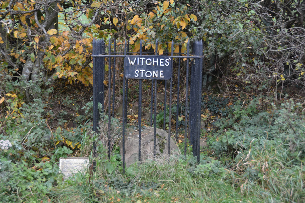
Witches' Stone (Spott) submitted by Anne T on 5th Nov 2018. This unprepossessing stone sits beneath a hedgerow, with a name sign and a small (now almost illegible information sign).
(View photo, vote or add a comment)
Log Text: The Witches' Stone, Spott: I had expected something a little grander than a large stone by the side of a hedgerow with a rusting iron railing and a sign that we could hardly read. There is a photograph on the Canmore record with a photograph of the sign from 2010 which is legible: “The Witches Stone of Spott. Marion Lillie, the Ringwoody Witch was burnt here in 1698. The stone is reputed to stand on the site of the burning of the last witch in the South of Scotland. Near to this site the Birley Tree stood, under whose branches the local Birley Court was held.”
I had to chuckle as whilst I was photographing a stone, another couple had stopped to take photographs of a brown sheep in a nearby field. Having taken quite a few photos, they continued their walk, walking right by this stone. Perhaps they’d seen it before. I found it touching that people still left coins here as offerings.
Gogar Stone
Trip No.105 Entry No.6 Date Added: 6th Nov 2018
Site Type: Standing Stone (Menhir)
Country: Scotland (Midlothian)
Visited: Yes on 28th Oct 2018. My rating: Condition 3 Ambience 4 Access 4
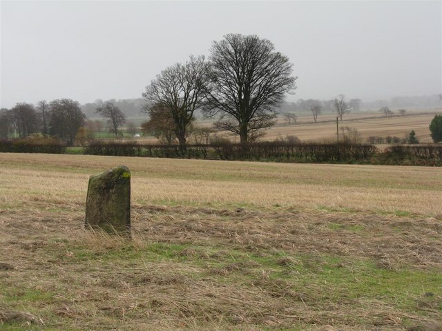
Gogar Stone submitted by Andy B on 13th Mar 2010. Standing stone at Gogar
Copyright M J Richardson and licensed for reuse under the Creative Commons Licence.
(View photo, vote or add a comment)
Log Text: The Gogar or Easter Norton Standing Stone: The last time I visited this stone, the field was planted with crop with no easy way of crossing the knee high rows of plants, so we viewed it from a distance. On this visit, the field had been left fallow, so we parked in the small layby on Freelands Road and walked through a gap in the hedgerow up to the stone. A large rook was perched on top of the stone, but flew off before I could take a photograph of it.
This stone has lots to keep it occupied during the day – planes taking off from Edinburgh airport to the north, trains on the mainline to the south, and cars on the M8. It was nice to be able to wander up to it, take photographs and see the stone up close.
The satnav took us by a funny route back to the A8 and whilst waiting to move off, a white van ran into the back of our car, just as a blue light ambulance was trying to get past. Not a good end to the day, but we decided to stop off at the Boar Stone on the way back as there was still just enough daylight.
St John's Well (Spott)
Trip No.105 Entry No.7 Date Added: 5th Nov 2018
Site Type: Holy Well or Sacred Spring
Country: Scotland (East Lothian)
Visited: Yes on 27th Oct 2018. My rating: Condition 3 Ambience 3 Access 4
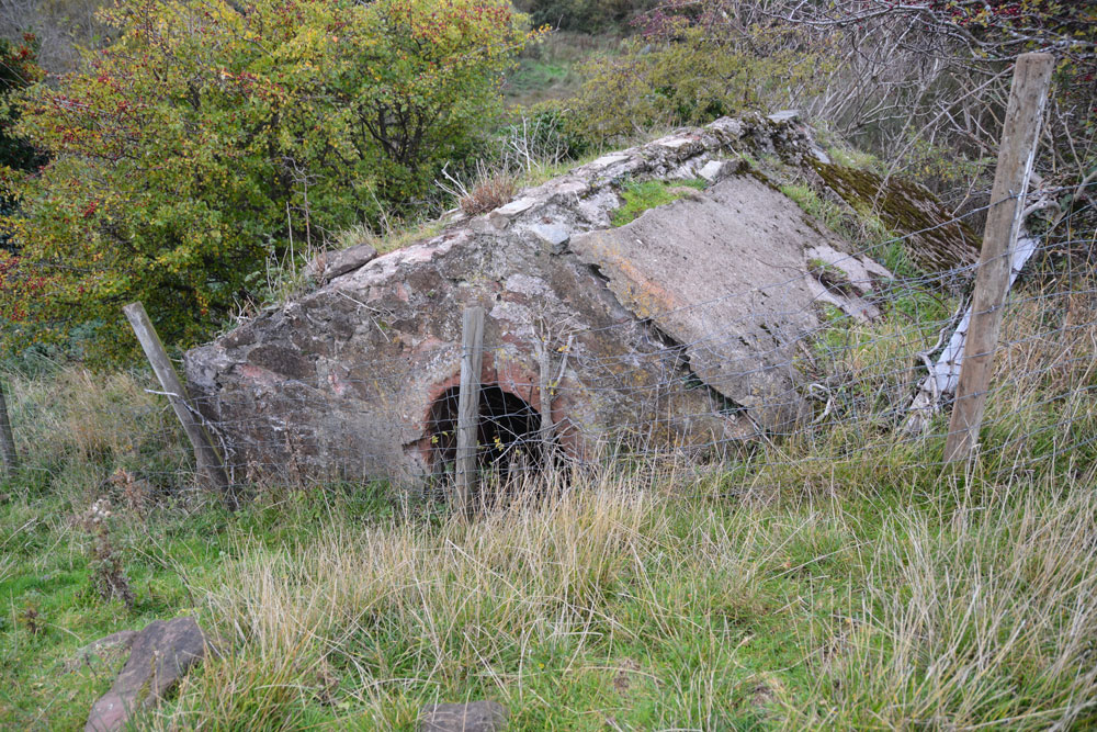
St John's Well (Spott) submitted by Anne T on 5th Nov 2018. This old cistern is some 100m further north, at the eastern side of the gully running from the well. I wondered if it was part of the 18th century works which piped water from this well into Dunbar.
(View photo, vote or add a comment)
Log Text: St John's Well, Spott: With the wind still whistling and starting to get dark, we really wanted to see this well and the nearby Easter Broomhouse standing stone before calling it a day. At the north eastern end of Spott, a gated stile by the small school lets you into the field, which, at the time of our visit, was full of very large, curious sheep.
Following the line of the first two telegraph poles, a gully comes into view. The well house is located at the top of this, at the bottom of the gully, so we needed to slither down the 6ft or so to the bottom to photograph the well.
Whilst the well cavity was dry, there was a pool of water a couple of metres further down the gulley.
Further down the field there was a very old, ruined building with an arched window. I am curious to know what this is – need to look it up on Canmore. Because of its location, my immediate thought was that it was a hermitage. No separate Canmore record, but is recorded on the map as a cistern.
Easter Broomhouse
Trip No.105 Entry No.8 Date Added: 5th Nov 2018
Site Type: Standing Stone (Menhir)
Country: Scotland (East Lothian)
Visited: Yes on 27th Oct 2018. My rating: Condition 3 Ambience 4 Access 4
Easter Broomhouse submitted by cosmic on 1st Jun 2008. Site in East Lothian:
Viewed from SE
(View photo, vote or add a comment)
Log Text: Easter Broomhouse Standing Stone: Dusk was falling as we arrived at this site, which I've long wanted to see. We parked by the water treatment works over the road at NT 67718 76493 and walked down the side of the ploughed area of the field until we were level with the stone, then ‘waded’ through the loose, ploughed soil until we reached the stone itself.
A lonely spot, although it has great views to the Firth of Forth and Bass Rock in the distance, to the north. It is a tall, sandstone pillar standing in an ocean of brown-red soil.
There are indeed 3 cups marks on its western face, along with some modern graffiti. The base of the stone has really been worn away; as the Canmore record says, this is the result of a steam plough cable.
