Contributory members are able to log private notes and comments about each site
Sites Anne T has logged on trip number: 93 (View all trips)
View this log as a table or view the most recent logs from everyone
Whitcastle Sike
Trip No.93 Entry No.9 Date Added: 31st Aug 2018
Site Type: Ancient Village or Settlement
Country: Scotland (Scottish Borders)
Visited: Yes on 29th Aug 2018. My rating: Condition 2 Ambience 3 Access 4

Whitcastle Sike submitted by Anne T on 31st Aug 2018. This panoramic view is the only way I could capture the form of this settlement, and is a stitch of three photos. Here I'm standing on a small bank which rises out of the tributary of Newmill Burn which runs to the western side of the settlement, forming a pool of water. The land to the north and west is marshy, and it looks as if the land has been built up around these sides to form a raised enclosure. Parts of the settlement have been quarried out. At the left hand side of the hill above is t...
(View photo, vote or add a comment)
Log Text: Whitcastle Sike Settlement: The OS map shows a group of settlements and hillforts which can be found to the east north east of Broxholme Easter Loch, and today in a pretty remote spot down a gated road. We parked at NT 43929 11939, at the wide entrance to a farm track/field entrance and walked to the gate into the field opposite.
On the map, it looked like these settlements would be pretty easy to pick out. Unfortunately, on the ground, the land had been heavily quarried and tall grass and bracken made picking out the land shapes a little tricky. We managed to identify this settlement by its location next to the stream. Whilst it had been heavily quarried, walking around its outline made it easier to identify.
To the west of this settlement is a very pretty burn which trickles past, forming pools in several areas. To the west and north, the ground around the settlement is boggy, but the area of the settlement is a metre or so above the water and dry; it looks as if the edges of the oval enclosure has been deliberately built up to form a protective kerb.
Midshiels Cairn
Trip No.93 Entry No.7 Date Added: 31st Aug 2018
Site Type: Cairn
Country: Scotland (Scottish Borders)
Visited: Yes on 29th Aug 2018. My rating: Condition 3 Ambience 4 Access 4
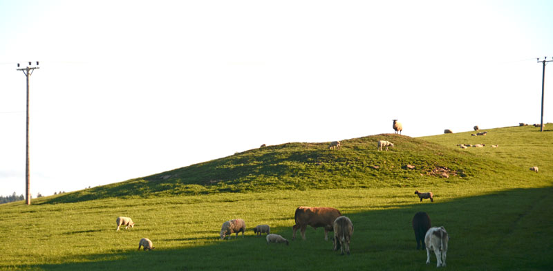
Midshiels Cairn submitted by Anne T on 4th Jun 2017. This is the closest we could get to the cairn on this visit - most of the young bullocks that had been on the right hand slope of the cairn were running (fast!) towards where we were standing at the gate to the field.
(View photo, vote or add a comment)
Log Text: Midshiels Cairn: Having been warned about the large cattle who might "go for us if they saw us", I was cautious about walking the additional 100m from the standing stone to the cairn. Andrew decided that as the cattle were at the far end of the field, and though large, looked relatively docile. “If they come for me I can always leap over the fence (to the railway embankment)”, he said, so I gave him the camera and left to explore the cairn, which seemed much further away than the standing stone, but in reality was only around 90m away.
The Canmore entry of 1948 says the cairn was ‘planted with trees’, although it is now only covered in grass.
Midshiels Standing Stone
Trip No.93 Entry No.6 Date Added: 31st Aug 2018
Site Type: Standing Stone (Menhir)
Country: Scotland (Scottish Borders)
Visited: Yes on 29th Aug 2018. My rating: Condition 3 Ambience 4 Access 4
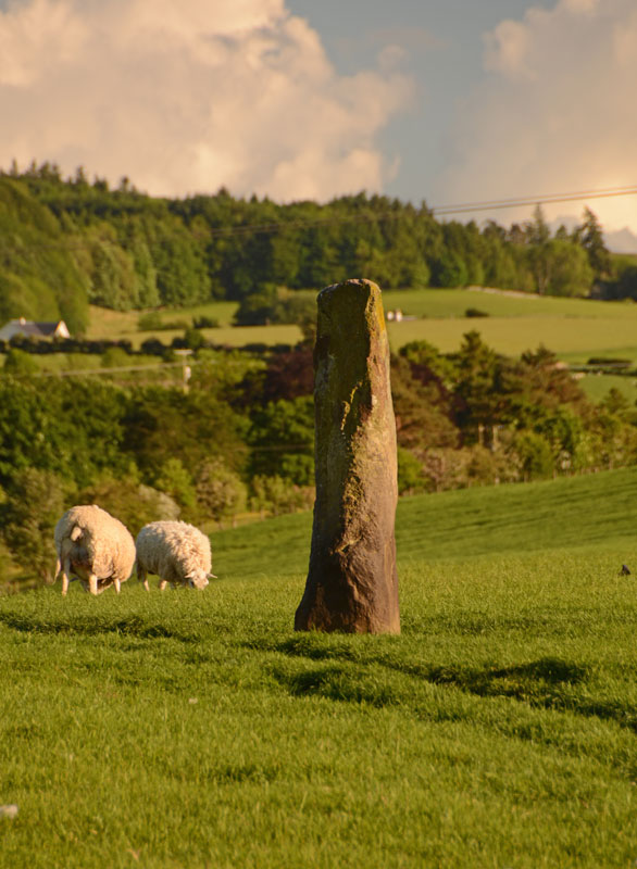
Midshiels Standing Stone submitted by Anne T on 4th Jun 2017. This is the nearest we could get to the standing stone on the evening of our visit. The field was full of quietly grazing sheep but many lively, curious young bullocks. The minute we started to open the gate, they were racing towards us.
(View photo, vote or add a comment)
Log Text: Midshiels Standing Stone, near Hawick: At our last visit, we were put off from entering the field because of a very large bull and his ladies. The bull stood guard near the stone, and any approach made him stand tall, with splayed legs, looking menacingly at us – I contented myself with taking photos from near the gate in the field.
At this visit we parked near the entrance to Midshiels farm, at NT 53459 17603, where we made sure we weren’t blocking the entrance into field. Immediately opposite, at NT 53461 17624 is a metal gate into the field, with the top of the stone just visible.
Husband, Andrew, opened the gate and was in the field, and I was just about to follow when a loud voice behind me stopped me going an further. There was a large, but friendly, farmer and his lad in a very large pickup truck. “There are bullocks in that field – if they see you, they’ll go for you. Drive into the next field and go up to the tunnel – you can turn round there. You can see the stone from there.” I thanked him for the ‘heads up’.
Andrew moved the car, but rather than drive the car up to the tunnel, the ground was a bit too uneven to risk the bottom of the car, so we left it at the edge of the field at NT 53518 17745 and walked to the gate near the tunnel at NT 53388 17830. From here, it looked as if all the cattle were at the far end of the field, with many of them lying down, although the hump in the middle of the field made it difficult to really see. We decided to take the chance and walk to the stone, as we could have got back to the gate quickly.
This stone was glorious in the sunshine, with a most peculiar small ‘hook’ to the top. I tried to capture the shadow in the strong sunshine.
Cavers Cross
Trip No.93 Entry No.5 Date Added: 31st Aug 2018
Site Type: Ancient Cross
Country: Scotland (Scottish Borders)
Visited: Yes on 29th Aug 2018. My rating: Condition 2 Ambience 4 Access 5
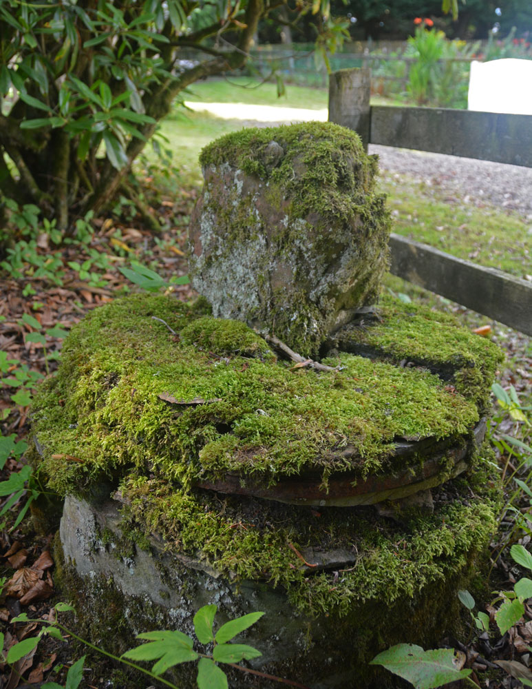
Cavers Cross submitted by Anne T on 31st Aug 2018. A view looking across the cross to the north, towards the small 'cross roads' in the centre of the hamlet of Cavers. The base is round but in pieces which have been stacked on top of each other, held together in places by old metal staples.
(View photo, vote or add a comment)
Log Text: Cavers Cross, near Hawick: From the motte, we drove round to Cavers – a very nicely kept estate, with well kept verges and few places to park along the straight, narrow road by the houses. In the end, we pulled right up to the fence at the largish entrance to a field gate at NT 54235 15805, intending to run back to the car if anyone thought we were in the way.
Walking south west towards the houses (I didn’t even recognise the Auld Kirk, as its been converted into a house with large driveway), we couldn’t see anything resembling a cross. There was a lady who was painting her fence and her large dog, who barked at us and sniffed my hands. I asked her if she knew of the remains of the cross, and she said, “Yes, but it’s only small”. She showed us where it was ‘hiding’ – behind a fence and shrubs in deep shade, then behind its own wooden fence, now much broken. She gave us permission to go into the garden of the holiday cottage as there was no-one there at the time of our visit. Whilst the Canmore record mentions the base of the cross (with the metal bands much visible), nothing is mentioned about the shaft it currently holds. This is of red sandstone and shaped, although much moss-covered.
Moving a small bit of stone near the join of the shaft and the base, there is evidence of a straight cut for part of the socket hole. We didn’t’ see any dowel holes, as the surface was moss and twig covered, but then the report that mentions this is dated 1933!
Fast Castle (Bedrule)
Trip No.93 Entry No.4 Date Added: 31st Aug 2018
Site Type: Misc. Earthwork
Country: Scotland (Scottish Borders)
Visited: Yes on 29th Aug 2018. My rating: Condition 2 Ambience 4 Access 4
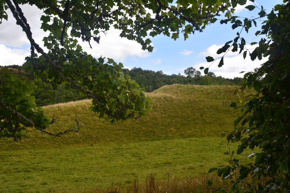
Fast Castle (Bedrule) submitted by Anne T on 31st Aug 2018. Our first view of this large earthwork/motte through the trees from the minor road from Bedrule to the Jedburgh Road.
(View photo, vote or add a comment)
Log Text: Fast Castle/Bedrule Motte: Not far from Bedrule Church this motte is marked on the map. At first it just appeared as a mound behind some trees, and we weren’t going to stop, until we realised the tree cover finished and the motte was clearly visible from the track going to Bedrule Mill. We let ourselves in through the gate and stopped to photograph this impressive mound. It sits by a bend in the very pretty river Rule.
Bedrule Parish Church
Trip No.93 Entry No.3 Date Added: 31st Aug 2018
Site Type: Sculptured Stone
Country: Scotland (Scottish Borders)
Visited: Yes on 29th Aug 2018. My rating: Condition 3 Ambience 4 Access 5

Bedrule Parish Church submitted by Anne T on 31st Aug 2018. A close up of the longer, almost rectangular hogback fragment, described as (2) in the Canmore record: "A fragment of a hog-backed tombstone measuring 1 ft. 3 1/2 in. in length by 7 in. thick, each side being 7 1/2 in. broad and showing three rows of shingle pattern."
(View photo, vote or add a comment)
Log Text: Hogback fragments, Bedrule Parish Church: (note for less mobile visitors, whilst access into the churchyard is on a tarmacked path, there are some steps up into the porch where these fragments are stored. Disabled access is signposted but the door was locked at the time of our visit). This parish church is in the tiny hamlet of Bedrule. We could see the church from the minor road, but had to go virtually through the village and turn south past a row of small cottages to reach the church. There was a small car park outside the churchyard gates. Rubens Law is to the south and dominates the view, which is rather nice.
The western side of the churchyard is divided into a series of ’garden rooms’, each with a small collection of interesting, old grave slabs, some dating to the 1650s.
The hogback fragments were inside the porch, along with a small stone with recumbent, robed figure. The fragments were underneath the small table with prayer and hymn books, so we moved the table out of the way (and replaced it), to photograph the fragments.
Hawthornside Farm (Bonchester Bridge)
Trip No.93 Entry No.1 Date Added: 31st Aug 2018
Site Type: Holy Well or Sacred Spring
Country: Scotland (Scottish Borders)
Visited: Yes on 29th Aug 2018. My rating: Condition 3 Ambience 3 Access 5
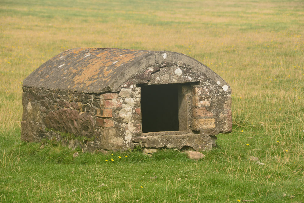
Hawthornside Farm (Bonchester Bridge) submitted by Anne T on 31st Aug 2018. This 'well house' is marked as a tank on the Canmore map, although the structure looks old and the chamber holds clear water. I'd love to know more about this well/tank if anyone has any information. We spotted it by chance trying to find our way to Bedrule.
(View photo, vote or add a comment)
Log Text: Well/tank, Hawthornside Farm (Bonchester Bridge): We spotted this ‘well house’ purely by chance as we passed by, then needing to turn the car round to go to Bedrule Church with its hogback fragments. This is a lovely site, right by the A6088. The well house (or ‘sink’ as it is labelled on the Canmore map) has Rubers Law Hillfort in the background.
There is no mention of Canmore, apart from the word ‘tank’ on its large scale map. The water appears to come straight up into the well basin – there is no sign of a pipe in or out. It does have the hinges for a (presumably wooden) door, which is no longer there. The water was beautifully clear and the inside of the structure clean.
Whitcastle Hill
Trip No.93 Entry No.10 Date Added: 31st Aug 2018
Site Type: Hillfort
Country: Scotland (Scottish Borders)
Visited: Saw from a distance on 29th Aug 2018. My rating: Condition 2 Ambience 4 Access 3
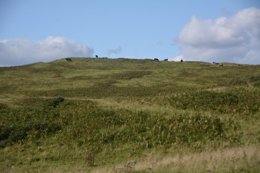
Whitcastle Hill submitted by Anne T on 31st Aug 2018. The groove of the outer defensive bank and ditch of this large prehistoric earthwork/hillfort can be seen at the top of the hill. Having already had one encounter with large cattle earlier in the day, we elected to return another day to take a closer look.
(View photo, vote or add a comment)
Log Text: Whitcastle Hill Prehistoric Earthwork: We decided to return to this site another day, having had a glimpse of the herd of very large cattle grazing over the site. Shame - the aerial photograph of this site on Canmore looks absolutely fascinating!
Rubers Law
Trip No.93 Entry No.2 Date Added: 31st Aug 2018
Site Type: Hillfort
Country: Scotland (Scottish Borders)
Visited: Saw from a distance on 29th Aug 2018. My rating: Condition 3 Ambience 4 Access 3
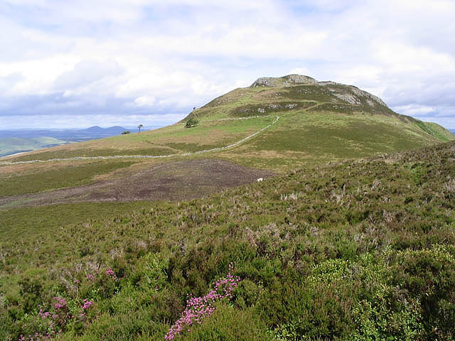
Rubers Law submitted by Creative Commons on 30th Aug 2010. Site in Scottish Borders Scotland
Approaching Rubers Law
Walking through heather near Cloon Craig towards the distinctive summit of Rubers Law with the Eildon Hills on the horizon to the left.
Copyright Walter Baxter and licensed for reuse under the Creative Commons Licence.
http://www.geograph.org.uk/profile/6638
(View photo, vote or add a comment)
Log Text: Rubers Law (only seen from a distance): This impressive hill fort dominates the area. We decided it was too far and too high to attempt today, although I was fascinated by its changing profile as we drove along the minor roads to Bedrule. We will come back when we're feeling fit and strong - it looks like a long walk, gaining height very quickly over a relatively short distance.
I stopped to take photo from the well house (MP 93.1), then at various points along the route:
1. NT 57304 12321
2. NT 59495 15298 By entrance to track signposted to Rubers Law
3. NT 59965 17983 From Bedrule Parish Church
Borthwick Mains
Trip No.93 Entry No.8 Date Added: 31st Aug 2018
Site Type: Class I Pictish Symbol Stone
Country: Scotland (Scottish Borders)
Visited: Couldn't find on 29th Aug 2018
Log Text: Borthwick Mains Possible Pictish Symbol Stone: We got the location of this symbol stone completely wrong, and whilst we found Borthwick Mains, did not find the symbol stone. Its now high on my 'wish list' to return to. A lot of building work had been happening here, with the entrance to the farm in the process of being widened, and the house nearest the road empty and almost derelict. I did venture into the garden, but not having any phone signal, did not have the photo of the stone on Canmore to refer to.
