Contributory members are able to log private notes and comments about each site
Sites Anne T has logged on trip number: 29 (View all trips)
View this log as a table or view the most recent logs from everyone
Midshiels Cairn
Trip No.29 Entry No.8 Date Added: 31st Jul 2017
Site Type: Cairn
Country: Scotland (Scottish Borders)
Visited: Saw from a distance on 3rd Jun 2017. My rating: Condition 3 Ambience 4 Access 4
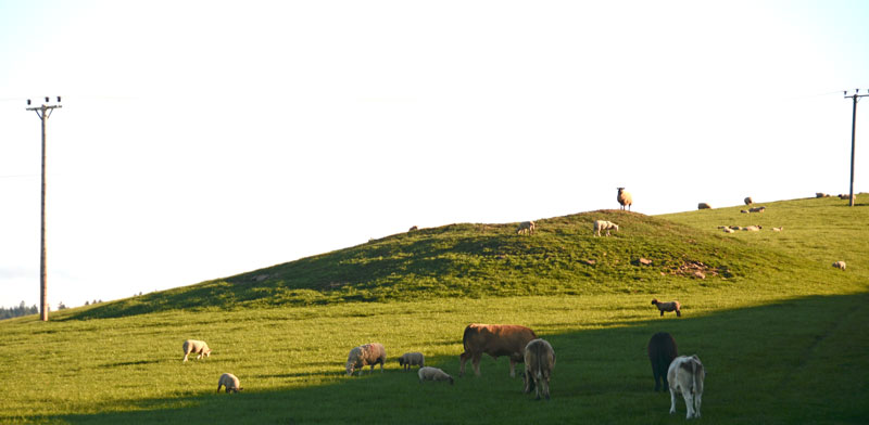
Midshiels Cairn submitted by Anne T on 4th Jun 2017. This is the closest we could get to the cairn on this visit - most of the young bullocks that had been on the right hand slope of the cairn were running (fast!) towards where we were standing at the gate to the field.
(View photo, vote or add a comment)
Log Text: Midshiels Cairn, Hawick: See visit report for Midshiels Standing Stone (the two are 90 metres apart), sites entered separately as Canmore lists them individually. Couldn't get really close to the cairn - would have loved to have walked up to it, but there was a really big bull and lots of over-friendly and very lively bullocks in the field. Must revisit at a different time of year!
There are plenty of other forts and settlements around here. The problem with another visit, is which sites to pick?
Hawick Mote
Trip No.29 Entry No.1 Date Added: 31st Jul 2017
Site Type: Misc. Earthwork
Country: Scotland (Scottish Borders)
Visited: Yes on 3rd Jun 2017. My rating: Condition 3 Ambience 3 Access 5
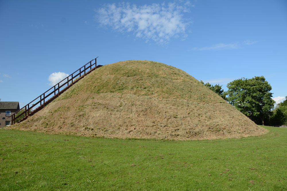
Hawick Mote submitted by Anne T on 27th Jul 2017. The Mote from the south western side, which has a ladder leading to the top of the mote which has an interpretation board.
(View photo, vote or add a comment)
Log Text: Hawick Motte/Mote, Scottish Borders: We arrived in Hawick, intending to buy a map, but the majority of the shops (apart from Dorothy Perkins, the bookmakers, charity shops and 1 café, were closed (looking at the opening times, they largely shut at 2pm on a Saturday. The town seemed deserted apart from a few tourists. We later found out that most local people had gathered near the community centre for the Riding of the Marches.
We couldn’t get a map, so relied on Andrew’s phone with TrigPoint on it. We were on our way to Lord’s Tree Cairn, driving down a street called Loan, when we spotted The Mote, so screeched to a halt by the side of the road and went round to take a photograph.
Quite extraordinary, The Mote is in the middle of a housing estate, with people’s washing hung up nearby. It rises steeply up out of the ground and there is a wooden staircase which takes you to the viewing point at the top. Andrew said it was only as large as our living room – no room for more than 12 people at most. Looking at this on UK Grid Reference Finder, it is located in Moat Park at the Southern end of the town. Plenty of dog walkers, all whom ignored me taking photographs.
The Dod
Trip No.29 Entry No.6 Date Added: 31st Jul 2017
Site Type: Ancient Village or Settlement
Country: Scotland (Scottish Borders)
Visited: Yes on 3rd Jun 2017. My rating: Condition 2 Ambience 4 Access 5
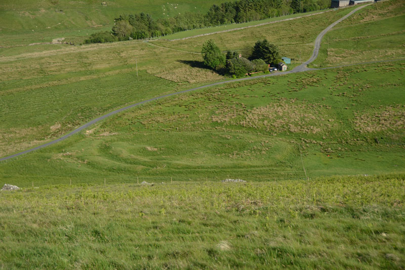
The Dod submitted by Anne T on 5th Jun 2017. The Dod settlement as seen from the slope just to the east of Burgh Hill Stone Circle.
(View photo, vote or add a comment)
Log Text: The Dod, near Bugh Hill Stone Circle and Hillfort: It was amazing what could be seen of this site from the slope just below Burgh Hill Stone Circle. Looking at the plan on Canmore, it is cut in two by the syke by the farm to it's south, but what remains, looking at the settlement from the road, are deep ditches and reasonably high banks.
The area is boggy, but the settlement can be reached by entering the field at its north-eastern end, walking westwards along the fence line next to the gate, then cutting across the field at the far end. For those not keen on boggy ground, a lot can be seen from the road.
Thankfully (after Burgh Hill Hillfort) The Dod was not windy! The sun was very strong at the time of our arrival here, and I struggled to avoid flare even using a polaroid and UV filters together. Was really pleased to have seen this site, but with so many other settlements and hill forts in the area, how to fit them all in? We decided to call it a day, calling in at Midshiels Standing Stone and Cairn on the way back home.
Burgh Hill Hillfort
Trip No.29 Entry No.5 Date Added: 31st Jul 2017
Site Type: Hillfort
Country: Scotland (Scottish Borders)
Visited: Yes on 3rd Jun 2017. My rating: Condition 3 Ambience 5 Access 3
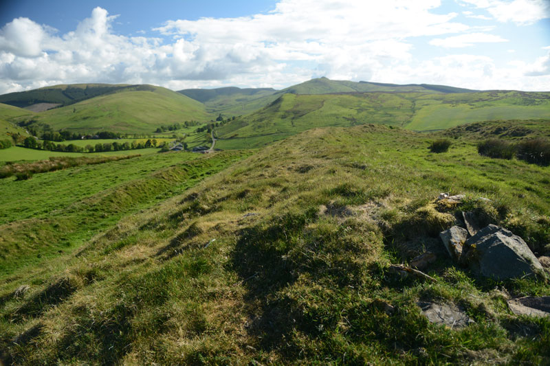
Burgh Hill Hillfort submitted by Anne T on 5th Jun 2017. Standing half way along the eastern upper bank of the fort, looking south west towards the hills beyond.
(View photo, vote or add a comment)
Log Text: Burgh Hill Hillfort, Scottish Borders: What is a 'bit more of a walk' for me is probably a 'short walk on a footpath' for others, but even so, this was a brilliant place to have visited.
With Burgh Hill Stone Circle (or possibly a cairn circle?) not far away, it was worth the additional short trek up to the south west summit of Burgh Hill. Goodness it was windy, although thankfully, as it was a nice warm spring/summer day, the wind was at least warm.
On the western side of the hillfort, the ground (as at Woden Law) dropped away sharply, making me take a quick step backwards to admire the views over the Allan Water valley below.
There are clear internal boundaries/banks/walls and a couple of hut circles, although these didn't come out very clearly on the photographs I took. There was a solitary large (standing) stone which didn't seem to be associated with any internal features.
The double banks and ditches on the south, east and northern sides of the fort were really visible, made of stone and earth, with two clear entrances to the north-east and south-west.
Burgh Hill Stone Circle
Trip No.29 Entry No.4 Date Added: 31st Jul 2017
Site Type: Stone Circle
Country: Scotland (Scottish Borders)
Visited: Yes on 3rd Jun 2017. My rating: Condition 3 Ambience 4 Access 3
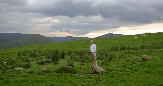
Burgh Hill Stone Circle submitted by nicoladidsbury on 17th Mar 2004.
(View photo, vote or add a comment)
Log Text: Burgh Hill Stone Circle, Hawick: After visiting Lord's Tree and Ca Knowe Cairns, we headed off towards Teviothead and some wild, lonely countryside. There is a track leading up the hill towards the stone circle (and the hill fort beyond), at NT 47365 06725, with parking for 2-3 cars opposite.
Following the track up the (reasonably steep) hill, we took the left hand fork and followed the mowed grassy track towards the stone circle. The circle lies just past the first peak with rocks outcrops to your right, but not as far as the fort. We went past the stones at first, having climbed too high up the hill, but Andrew found a metal pole with a large aluminium star attached to it, presumably marking this as an archaeological site.
Looking at the site on UK Grid Reference Finder, the circle lies in between two small banks running in very shallow arcs. The stones of the circle seem to lie in a dip with a small bank around. It reminded me very much of a cairn circle rather than a stone circle, as none of the stones seemed to be worked in any way, and they were all comparatively small. I note the Canmore record for this site says it's been re-designated a Stone Setting rather than a stone circle.
Having stayed to enjoy the views, and also photograph the Dod settlement from above, we climbed up to the fort, where it was VERY windy (but thankfully the wind was warm).
Midshiels Standing Stone
Trip No.29 Entry No.7 Date Added: 31st Jul 2017
Site Type: Standing Stone (Menhir)
Country: Scotland (Scottish Borders)
Visited: Yes on 3rd Jun 2017. My rating: Condition 3 Ambience 4 Access 4
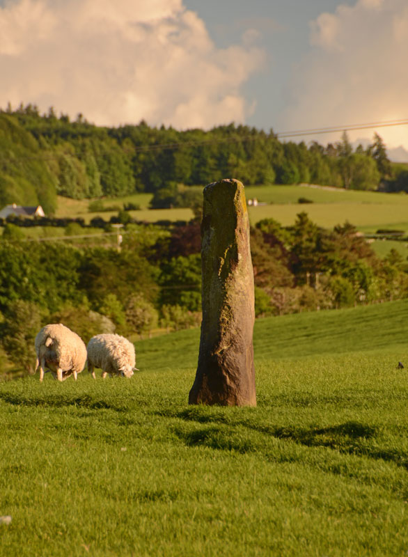
Midshiels Standing Stone submitted by Anne T on 4th Jun 2017. This is the nearest we could get to the standing stone on the evening of our visit. The field was full of quietly grazing sheep but many lively, curious young bullocks. The minute we started to open the gate, they were racing towards us.
(View photo, vote or add a comment)
Log Text: Midshiels Standing Stone, Hawick: We'd arrived (unknowingly) in Hawick on their Riding of the Marches day. The shops were shut and the town was almost deserted. Having visited some other sites on the southern side of Hawick, we decided to stop off to see this standing stone and cairn on the way back home. Following the curious one-way system though Hawick, we ended up on the Borders Abbey Way heading north-east out of the town. At Bucklands, we found where the entire town was - at a community centre at the edge of the town. A marshall stopped us and told us we wouldn't be able to get any further up the road as the procession of horses was coming through. Doubling back through the industrial estate, we took the A698 out of town, turning left over the picturesque Hornshole Bridge, rejoining Borders Abbey Way a few hundred yards before the entrance to Midshiels Farm.
A couple of hundred yards further north-east along the road, there was a large passing place, so we hugged the car into the hedgerow and hopped out. About 50 metres further back, on the other side of the road, a gate let us into the field leading to the dismantled railway embankment to the west. Following the left hand hedge-line along, we came to another gate, just before a tall brick bridge leading under the railway line. This gate gave access to the field with the standing stone and cairn.
However, the field was full of gently grazing sheep and lots of lively, curious bullocks along with what looked like a very large bull. My hand went onto the gate and they were running towards us. I elected to use the zoom lens on the camera, and was really disappointed not to have seen this standing stone closer up. But there is lots to see in this area, so undoubtedly a return visit will be in the offing at some point in the not too distant future.
Ca Knowe (Hawick)
Trip No.29 Entry No.3 Date Added: 31st Jul 2017
Site Type: Cairn
Country: Scotland (Scottish Borders)
Visited: Yes on 3rd Jun 2017. My rating: Condition 2 Ambience 4 Access 4
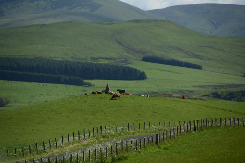
Ca Knowe (Hawick) submitted by Anne T on 4th Jun 2017. Ca Knowe Cairn from Lord's Tree Cairn.
(View photo, vote or add a comment)
Log Text: Ca Knowe Cairn, Hawick (aka Hero's Grave): Simply marked as ‘cairn’ on Trigpointing UK's OS map, we could see this cairn from Lord’s Tree Cairn. There is a proper tarmacked footpath up to the modern standing stone with plaque on it. Closer to, it is much larger than it appears from the mark on the map, and has a proper tarmacked path up to it.
Unfortunately, both on our way to our next site, and our way back to Hawick, the monument was surrounded by a number of very large cows with their calves, so we decided not to risk upsetting them and drove on after having taken some photographs.
Lord's Tree (Hawick)
Trip No.29 Entry No.2 Date Added: 31st Jul 2017
Site Type: Cairn
Country: Scotland (Scottish Borders)
Visited: Yes on 3rd Jun 2017. My rating: Condition 3 Ambience 4 Access 4
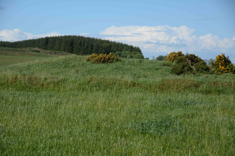
Lord's Tree (Hawick) submitted by Anne T on 4th Jun 2017. Standing at the southern side of the cairn looking up the slight slope to the low mound of the cairn. The circular bank around the cairn clearly visible.
(View photo, vote or add a comment)
Log Text: Lord's Tree Cairn, Hawick: We arrived in Hawick, intending to buy a map, but the majority of the shops (apart from the bookmakers, charity shops and 1 café, were closed (looking at the opening times, they largely shut at 2pm on a Saturday. The town seemed deserted apart from a few tourists. We later found out that most local people had gathered near the community centre for the Riding of the Marches.
Relying upon the Trigpointing UK maps (good job there was a phone signal!), we navigated our way through the town (stopping off to look at The Mote on the way), past the golf course and out into the glorious open countryside with the hills beyond.
This cairn appears as a slight bump at the top of a small rise of a hill; it's unmistakably a large, low cairn, and the lush green grass and wild flowers invited a walk through the meadow towards it.
Completely circular, there is a low bank surrounding the cairn. Shame the old Lord's Tree wasn't there. Lovely view down to Ca Knowe Cairn further south.
