Contributory members are able to log private notes and comments about each site
Sites Anne T has logged on trip number: 108 (View all trips)
View this log as a table or view the most recent logs from everyone
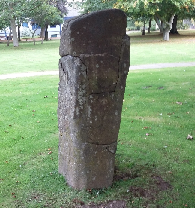
Randolphfield Stones
Trip No.108 Entry No.1 Date Added: 8th Nov 2018
Site Type: Standing Stones
Country: Scotland (Stirling)
Visited: Yes on 30th Oct 2018. My rating: Condition 3 Ambience 3 Access 4

Randolphfield Stones submitted by rogerkread on 16th Oct 2015. The larger stone, showing evidence of destruction and subsequent repair.
(View photo, vote or add a comment)
Log Text: Randolphfield Stones, Sterling: This visit felt really strange, as the stones were literally in front of the police station, and I wondered if I’d get a tap on the shoulder and the memory card from my camera confiscated! No one seemed to turn a hair, though I took a number of photographs of both stones.
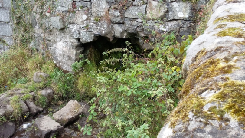
Butt Well
Trip No.108 Entry No.2 Date Added: 9th Nov 2018
Site Type: Holy Well or Sacred Spring
Country: Scotland (Stirling)
Visited: Yes on 30th Oct 2018. My rating: Condition 3 Ambience 4 Access 4

Butt Well submitted by rogerkread on 16th Oct 2015. The waters which would once have flowed into the Butt Well now tumble down the hillside on the far side of the wall behind the wellhead.
(View photo, vote or add a comment)
Log Text: Butt Well, Sterling Castle: We parked in the layby near the King’s Knot, just off the A811. There is a footpath signposted to Butt Well leading through the field next to the layby, just down the grassy slope.
Walking up towards the Castle, we were met by a fair number of dog walkers walking to or from the well. The footpaths here look as if they give access up to the castle, but we stopped short at the well.
Our first sight of part of this feature was a small well chamber, still with a fair flow of water running into it, just over the dry stone wall, below the main well housing and at the bottom of the flight of steps, at NS 78937 93894. The water from this runs in a small channel across the field to the northern side of the wall, at the opposite side to the footpath. Looking down at this chamber from above, there appears to be the remains of a stone drinking trough just outside the chamber, but largely buried under the grass and weeds around it.
The well itself, at NS 78948 93898, is now dry and capped off, with a handy bench next to it.
Climbing up the few steps above the main well housing, there is a channel running underneath the footpath running off to the north west at NS 78952 93902.
As I was photographing the well, a young black Labrador was running around with a large tree branch in his mouth. I was laughing at him, and his owner came up and asked us where we were from. He said when he was young, he used to play on the ‘cup and saucer’ (the King’s Knot) then run up here for a drink; “the water was the clearest you’ll ever taste”. He told me that they’d capped the well off some 20 to 30 years ago.
St Ninian's Well (Stirling)
Trip No.108 Entry No.3 Date Added: 10th Nov 2018
Site Type: Holy Well or Sacred Spring
Country: Scotland (Stirling)
Visited: Yes on 30th Oct 2018. My rating: Condition 3 Ambience 2 Access 5
St Ninian's Well (Stirling) submitted by KiwiBetsy on 16th Oct 2006. It is said that a chapel stood near the well and was still in existence in 1497 but that none of it now remains and the structure now covering the well is a wash house.
(View photo, vote or add a comment)
Log Text: St Ninian's Well, Stirling: This was just over the road from the Wellgreen Carpark, but we had difficulty in finding this well, because of its rather hidden location. Despite the GPS telling us we were only 20m away, we were unable to find it until we saw the footpath leading to Wellgreen Place at the southern side of the A811 Wellgreen Road. Shame the area is used by smokers, as the rubbish is horrible.
Opposite the well, nearer to the office block is a small set of steps leading upwards to a now very much overgrown garden area. The steps are virtually hidden under shrubbery, and although Andrew had a try at climbing up, it was very difficult and we gave up and went onto our next destination.
King's Park Cup and Rings
Trip No.108 Entry No.4 Date Added: 10th Nov 2018
Site Type: Rock Art
Country: Scotland (Stirling)
Visited: Yes on 30th Oct 2018. My rating: Condition 3 Ambience 4 Access 4
King's Park Cup and Rings submitted by SolarMegalith on 27th Jun 2017. Cup-and-ring mark on King's Park panel seen in the artificial lighting (photo taken on May 2017).
(View photo, vote or add a comment)
Log Text: King's Park Cup and Rings, Sterling: From Stirling, we headed off to south end of King’s Park which lies south of the A811 Dumbarton Road. The rock art panel is located at the southern end, near the golf course.
We parked on Douglas Terrace and used the little cut-through to the park at the eastern end of the row of terraced houses before its junction with Park Place. We then turned west along the footpath that ran along the bottom of the cliffs, but had to double back and use the footpath and steps up to the golf course, just to the right of the cut-through. From here, we turned west along the footpath. The grid reference is spot on, and the rock had had the turf cleared from it. The low light at this time of the afternoon helped to pick out the motifs.
I wondered what other motifs there might be around here, as the footpath here runs along the top of some small cliffs, but these were heavily wooded.
St Thomas's Well (Cambusbarron)
Trip No.108 Entry No.5 Date Added: 10th Nov 2018
Site Type: Holy Well or Sacred Spring
Country: Scotland (Stirling)
Visited: Yes on 30th Oct 2018. My rating: Condition 3 Ambience 4 Access 5

St Thomas's Well (Cambusbarron) submitted by peigimccann on 27th Sep 2016. St Thomas's well pond.
(View photo, vote or add a comment)
Log Text: St Thomas's Well, Cambusbarron: St Thomas’s Well is not far from the rock art panel. Going back to the car, we drove further down Douglas Terrace, past the grave yard, to where the road (St Thomas’s Well) turns right. The well is just past it’s junction with the Old Turnpike Road.
This well is in a private garden. It is possible to walk all the way round the well pool, but not to access the garden. The pool still had water in it, but only a relatively small amount. The whole pool was around 30m across. At its western side, there was a paved area with a round well basin built into it, but this looked like a garden feature rather than part of the well structure.
By the names and the old buildings, this is obviously a very old location with history, but no longer has the atmosphere with the modern houses built up around the historical sites. The busy M9 lies almost immediately to the west, although the noise of the traffic was masked to some extent by the buildings between the well and the road.
Chapel Well (Cambusbarron)
Trip No.108 Entry No.7 Date Added: 10th Nov 2018
Site Type: Holy Well or Sacred Spring
Country: Scotland (Stirling)
Visited: Yes on 30th Oct 2018. My rating: Condition -1 Ambience 2 Access 4

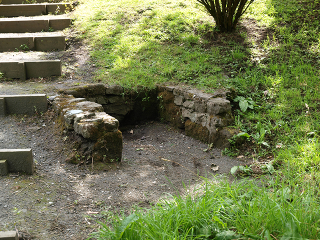
Chapel Well (Cambusbarron) submitted by peigimccann on 12th Sep 2016. Bruce's Well 7-7-09
(View photo, vote or add a comment)
Log Text: Bruce's Well, Cambusbarron: Even with the GPS from the Portal, we had great trouble finding this well, and in the end had to ask two locals. One pointed us to an old water fountain in a nearby park, now repurposed as a planter; the other took us to a footpath by the side of a small stream and pointed us down the path, saying “a lot of people come to look, but there’s not really much to see.”
We found the steps, as photographed on the Portal, but there was a sign declaring this the site of the well only.
In the middle of the village, a police officer was standing in a doorway with a number of people outside making phone calls. As we headed up the steps from the site of the well back to the car, a white clothed forensics officer exited the house. Haven't found out what happened, but this certainly made it a memorable visit to the site of this well.
Coneypark Nursery (Cambusbarron)
Trip No.108 Entry No.6 Date Added: 10th Nov 2018
Site Type: Cairn
Country: Scotland (Stirling)
Visited: Yes on 31st Oct 2018. My rating: Condition 2 Ambience 3 Access 5

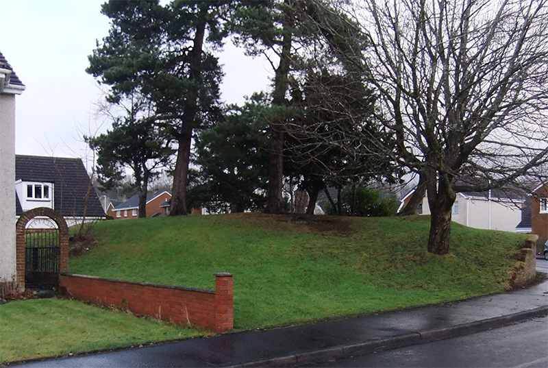
Coneypark Nursery (Cambusbarron) submitted by peigimccann on 24th Dec 2017. Coneypark mound photo by David Sibbald
(View photo, vote or add a comment)
Log Text: Coneypark Nursery Cairn: This cairn is right in the middle of a modern housing estate, where it has been left as a corner ‘open space’. The sides of the cairn have been marginally cut away to create the road and the gardens for the houses, but it is possible to walk over the cairn. A few of the residents were arriving home and in their driveways; none of them took (much) notice of me taking photographs and having a walk all around the cairn.
There is nothing much to see here, but it was ‘one to tick off our list’.
