Contributory members are able to log private notes and comments about each site
Sites Anne T has logged. View this log as a table or view the most recent logs from everyone
Birtley Iona Cross
Date Added: 7th Oct 2014
Site Type: Ancient Cross
Country: England (Northumberland)
Visited: Yes on 2nd Oct 2014. My rating: Condition 4 Ambience 4 Access 5
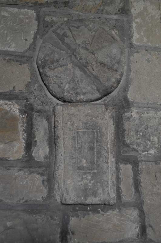
Birtley Iona Cross submitted by Anne T on 6th Oct 2014. An undated Saxon cross-shaft fragment and circular grave marker/dedication cross from the second half of the 11th century are built into the northern wall of the nave near the font.
(View photo, vote or add a comment)
Log Text: Iona Cross, Birtley (St. Giles, Birtley): From St. Giles in Chollerton, this church is easy to find, being only 6 miles away. To reach it, drive down the small road to the left hand side of the church and continue on down through Barrasford, turning right just before reaching the village of Wark (signpost says Birtley is 2 miles). The church is then on your right hand side as you enter the village. It sits with it’s narrowest (west side) next to the road and is hidden under trees, so it’s only when I saw the grave yard that I realised I’d arrived. I drove up into the village to turn around (been here for a walk years ago and parked at the top end of the village) and bumped up onto the pavement to park by the gate to the church.
The present church was rebuilt in the 18th century and renovated in the 19th century, and has a wonderful feel the minute you step through the door.
Opening the porch, there are grave covers built into the wall, and glorious flower arrangements left to welcome visitors as you enter.
Rev. Slade had told me about the Iona cross before my visit, so I left this until last to find. Three of the fragments are built into the north wall (two of them together, these near the font). The Iona cross is in the chancel. The fourth was high up on a ledge in the porch (I would have missed this had I not looked a third time to find it – didn’t think to look up).
Chollerton Cross
Date Added: 7th Oct 2014
Site Type: Ancient Cross
Country: England (Northumberland)
Visited: Yes on 2nd Oct 2014. My rating: Condition 4 Ambience 4 Access 5
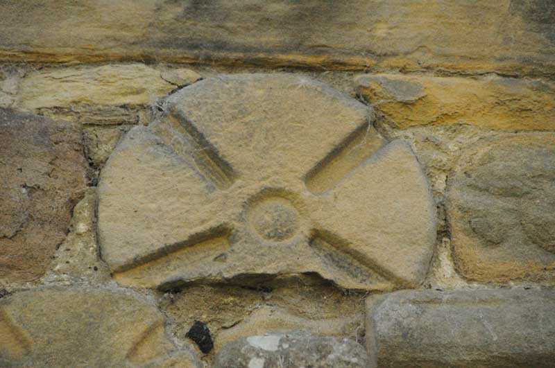
Chollerton Cross submitted by Anne T on 6th Oct 2014. Close up of 'Chollerton 02', part of a cross-head (reference from the Corpus of Anglo Saxon Stone Sculpture).
(View photo, vote or add a comment)
Log Text: Chollerton Cross (St. Giles, Saxon Crosses, Chollerton): It being the most beautiful sunny day with blue skies (but a frosty start), it was a perfect autumn afternoon. Last night I looked through the Anglo Saxon Corpus database and picked out some places within easy reach of my house.
My husband and I have been to St. Giles before, on 30th August 2007, but to look at the Roman features incorporated into the church and I had the tiniest little camera which took appalling photographs!
The tower was completely scaffolded and three or four men were working at the top of it in the sunshine. Parking by the old mortuary building, as I was changing lenses on my camera an elderly lady came across the road. She said she was waiting for the bus to come down and told me how she and her brothers and sisters used to come and clean the church when they were young; her father had changed the altar cloths and put everything ready for communion. She also told me how lucky they were to have someone as nice as Rev. Slade.
I found the Anglo-Saxon crosses on the north wall of the nave easily enough. On opening the door to the porch, there was part of another Saxon cross built into the wall above the door to the church.
The sun was so strong it was difficult to get a shot of the church without overexposing the shot, even at 1/4000th of a second.
In the guide book, a pretty child’s grave cover is described as sitting next to an 18th century sundial. I found the sundial, but next to it was a bucket of stone fragments. Despite walking twice round the church, I was unable to find this grave cover, so assume it’s either been broken or moved. I was touched by a pair of slippers kept by the font!
The guide book says that the church is Grade 1 listed, sited at the southern most end of Chollerton parish, was consecrated in 1097 and is the “mother church” of the parish. The name Chollerton derives from Anglo Saxon (Cholverton, Cholreton, Cholveriton).
The guide goes onto say the original church was probably wooden, with the stone church built around 1260 by William de Swinburne a Scottish knight (presumably there are links between his family and Swinburn Castle, with its standing stone) not far away. Part of the 12th century remains in the west walls between the nave and the tower tower and Roman piers have been used to create the south arcade.
There is a Roman font inside, dedicated to Jupiter, which has been inverted and modified for use today, although a more modern (13th century!) font with a Jacobean lid is in use today.
There is parking for two cars next to the old stable and hearse house with its mounting block, and it is possible to get a wheelchair up to the church (although not around to the north wall of the chancel to see the Saxon stones).
The Anker's House
Date Added: 2nd Oct 2014
Site Type: Ancient Cross
Country: England (County Durham)
Visited: Yes on 25th Sep 2014. My rating: Condition 4 Ambience 5 Access 5
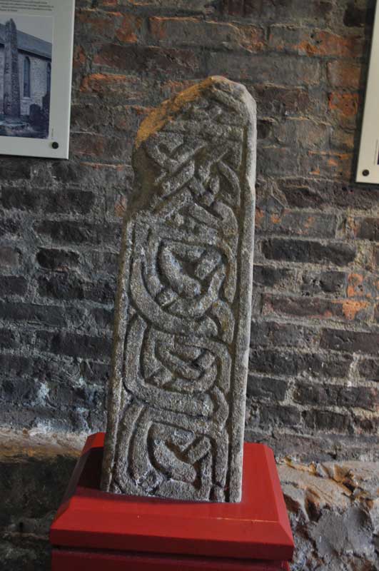
The Anker's House submitted by Anne T on 30th Sep 2014. Upper part of cross-shaft from the first half of tenth century.
Anglo-Saxon Stone Sculpture reference = Chester-le-Street 02.
(View photo, vote or add a comment)
Log Text: The Anker House (Anglo Saxon Cross Shafts and Cross Arms): The purpose of my visit was to see the Anglo Saxon cross fragments, but the impact of this visit is still with me today - the tiny little Anker House and what it meant to commit yourself to the rest of your life in this tiny village was quite a spiritual awakening for me.
I am very nervous about driving to places I've never been to before, and I was a bit of a quiver thinking about how to drive to Chester-le-Street and find the church. From Bywell, rather than drive the longer way down the A695/A1, I went down the B6309/A693, which was easy enough, as it was signposted Beamish Museum then Chester le Street.
Chester le Street was actually bigger and busier than I remembered from a visit to Langley Castle for a conference many years ago, but the spire of the church stood proud behind the shops on the left hand side of the main shopping street, so at the roundabout at the edge of the shops, I turned left and found two car parks straight away. Parking was only 80p for 3 hours (the machine wasn’t accepting certain coins so I was committed to paying 80p or £1) and the Ankers House was signposted from the car park. It was only round the corner.
Wow. I am so pleased I took the time to come here.
When I first arrived, the ladies couldn’t find the key so I had to wait for someone to come back to the church from the Parish Office (which wasn’t long really) and the ladies kept me engaged in conversation, pointing out the squint from the built in Anchorite House and the slot where food was pushed through into the house.
The house was quaint and minute and ancient. It has been extended in modern times, but it was easy enough to get an idea of what it would have been like. The stewards told me that before the Anchorite was walled up in the house a funeral service was held in the church for them so they could say ‘goodbye’ to the real world.
Whilst the atmosphere in the museum was quiet and gentle it was also somewhat spooky and it was very odd to be shut in there alone. I sort of hurried to get through taking my photos, especially as the door to the outside world kept banging in the breeze. Some of the items were apparently on loan to a Lindisfarne Gospels exhibition (the lady said I should speak to ‘Mike’ but no further details).
They had a copy of the Lindisfarne Gospels in the church – apparently they were translated from Anglo-Saxon to Latin on this site. Kept in a glass case and covered with a red cloth, the ladies lifted the cloth to give me a sight of this impressive (modern) copy. A superb afternoon. Shame the museum is not open again until next spring.
St Andrew's Church (Bywell)
Date Added: 2nd Oct 2014
Site Type: Ancient Cross
Country: England (Northumberland)
Visited: Yes on 25th Sep 2014. My rating: Condition 3 Ambience 4 Access 5
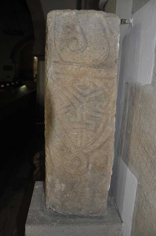
St Andrew's Church (Bywell) submitted by Anne T on 30th Sep 2014. Close up of the second decorated side of the larger fragment, which is the lower part of a cross shaft (Corpus of Anglo-Saxon Stone Sculpture reference: Bywell 01). This face shows the remains of a ring knot and shield shaped pendant.
(View photo, vote or add a comment)
Log Text: Bywell Anglo Saxon Cross (St. Andrew's Church): This is a very pretty spot, nestled in a bend of the River Tyne, surrounded by neatly kept estate lands. The two neighbouring churches on this site are less than 2 miles from my house, but although I've been here on more than one occasion, can't say I've noticed the Anglo Saxon cross in St. Andrew's.
The grid reference on the Anglo-Saxon Corpus Stone Sculpture web site indicated that the cross shaft was located at St. Peter's rather than in St. Andrew’s, the Churches Conservation Trust church, but instinct told me otherwise. However, I went to check anyway. This is the first time I’ve been able to get into the St. Peter's during the day to look around (outside carol services). I was investigating when I heard the west door rattle, which gave me the creeps. There was another gentleman who was walking from Ovingham and wanted to come and look, so we exchanged a few courtesies as we walked around.
What I hadn’t realised was that there were some interesting grave covers with crosses built into the porch of the church.
I couldn’t find the cross shaft, so set off to St. Andrew’s where I saw the stone as soon as I walked through the door.
St Andrews, Bywell Grid reference: NZ 04837 61485
The prettiness of the church, with its unique Saxon tower, never fails to hit me every time I come here. I always remember a good friend's reaction to this when we stopped off here on the way to our presentation at Aykley Heads ("makes me want to get my walking boots on").
The cross shaft is located to the north side of chancel, between the choir stalls and the altar.
St Peter (Osmotherly)
Date Added: 29th Sep 2014
Site Type: Ancient Cross
Country: England (Yorkshire (North))
Visited: Yes on 26th Sep 2014. My rating: Condition 3 Ambience 4 Access 5
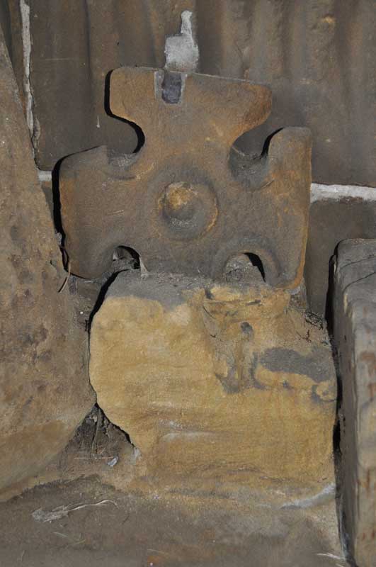
St Peter (Osmotherly) submitted by Anne T on 29th Sep 2014. I was really interested in this Saxon cross head fragment. It is amongst the group on the bench on the western wall of the porch.
(View photo, vote or add a comment)
Log Text: St Peter’s Church, Osmotherley. Saxon cross fragments: Note, whilst there is parking on School Lane immediately by the church, there are steps to negotiate from the road up to the church.
Having failed to get to Mount Grace Priory and St. John’s Well from the northern carriageway of the A19 (there is only access from the southbound carriageway), we went into Osmotherley as I’d seen St. Peter’s and their Saxon cross fragments on the Portal.
St. Peter’s really was ‘the disappearing church’ – coming down North End, it towered over the houses but as we turned to go up West End and got closer to it, it disappeared and we lost our bearings. After two attempts of driving up and down, we turned down School Lane (not Church Lane, as we might have expected!), which, whilst narrow there is parking.
The cross shaft fragments are in the porch of the church, which is open to the weather, so available to visit anytime.
As I was making my way up the steps towards the church porch, there were some ladies coming slowly down the steps towards us. The first lady told us they had just had a choir practice for Harvest Festival, and if I was quick, I could look round the inside of the church.
This church has a lovely atmosphere, and I’d like to go back and have a more leisurely look. The ladies told me that the south nave is Victorian, so the Norman porch must have been moved when this was built.
I saw the cross fragments and photographed them, with the kind ladies surrounding me – all lovely and really interested. They told me about other crosses at Sockburn and St Wilfrid’s Parish Church in South Kilvington to add to my list of places of ‘must see’ sites.
Pudding Pie Hill
Date Added: 29th Sep 2014
Site Type: Round Barrow(s)
Country: England (Yorkshire (North))
Visited: Yes on 26th Sep 2014. My rating: Condition 3 Ambience 4 Access 4
Pudding Pie Hill submitted by rogerkread on 11th Sep 2014. The large mound of Pudding Pie Hill.
(View photo, vote or add a comment)
Log Text: Pudding Pie Hill, Sowerby near Thirsk: From St Mary The Virgin at Leake, we headed south to Thirsk, leaving the A19 at its junction with the A168 to get as close as we could to Pudding Pie Hill.
It wasn’t possible to get to the round barrow from this direction, as there are all private roads leading to houses and small holdings, so we tried driving back into Thirsk and back round to Sowerby.
I always like coming to Thirsk, but never been to Sowerby, and it’s a really quaint little village. Blakey Bridge was closed to traffic so we walked across, through the field with Cod Beck to our right hand side.
The barrow rises up out of what appears to be the flood plain for the Cod Beck. If it weren’t for the very busy A168 roaring past on the eastern side, this barrow would be in a lovely spot indeed.
There is an information board by the footpath leading up to the barrow which explains something of the history and has old photographs of children on the barrow.
We walked up to the top of the mound, and there is indeed a hollow where they excavated it in the nineteenth century.
The ditch around the mound can be seen to its eastern and southern sides. Definitely worth coming to visit briefly.
Howe Hill (Felixkirk)
Date Added: 29th Sep 2014
Site Type: Round Barrow(s)
Country: England (Yorkshire (North))
Visited: Yes on 26th Sep 2014. My rating: Condition 2 Ambience 4 Access 5
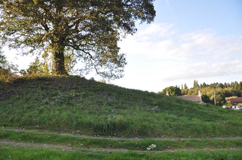
Howe Hill (Felixkirk) submitted by Anne T on 29th Sep 2014. Standing between the minor roads (leading north and north east from the base of the mound) and the metalled driveway, looking back towards the Carpenters Arms (the church is just off shot to the top right hand side).
(View photo, vote or add a comment)
Log Text: Howe Hill Round Barrow, Felixkirk: After having been to Pudding Pie Hill Round Barrow in Sowerby, we drove to the village of Felixkirk from the A170, up the first minor road leading north east. There is no doubt that Howe Hill is something ancient – but what? My initial impression, driving up the hill into the village was that it was a motte, but then it’s too small for a castle.
Howe Hill is immediately opposite the Carpenter’s Arms public house, which has a large car park, and the Howe Hill mound rises up above you. As it is topped by a very large tree, the mound seems to dominate everything around it (in a nice sort of way).
It is possible to sit outside the pub to have a meal and a drink and admire Howe Hill. It being now early evening and getting chilly, we sat inside and had a drink, looking out onto the mound, waiting for the angle of the sun to dip below the mound so I could get some photographs.
However – the monument has sort of been developed around in a somewhat insensitive manner - someone’s driveway (the Old Vicarage? Now up for sale) up its left hand side (facing from the pub), also someone has used the southern side of the mound to burn old tree trunks, which has left a mess. There’s also a road junction with numerous signposts to the northern end of the barrow and the right hand side been landscaped into edge of someone’s drive, but it is still recognisable as an ancient site.
The English Heritage record (not to be confused with How Hill, west of Richmond, North Yorkshire) says that this is a bowl barrow, dating from the Late Neolithic to the Late Bronze Age.
St Felix Church is only a short distance away (different web sites vary between 130 and 200 yards!). Apart from the sheep keeping the grass short in the church yard (this did keep the graveyard looking very neat) and the remains of the Norman windows in the chancel, this church had been extensively modernised, and I was disappointed.
In my opinion, Howe Hill is only worth stopping to look at if you are passing by. Sorry!
St Mary (Leake)
Date Added: 29th Sep 2014
Site Type: Ancient Cross
Country: England (Yorkshire (North))
Visited: Yes on 26th Sep 2014. My rating: Condition 3 Ambience 4 Access 5

St Mary (Leake) submitted by Anne T on 29th Sep 2014. St. Mary The Virgin, Leake, taken from the churchyard wall nearest the A19, looking back at the west end of the Norman tower.
The Saxon cross can just be seen in the centre of the image, just above the window arch.
(View photo, vote or add a comment)
Log Text: St Mary’s Church, Leake: Saxon Cross and Sundial: I hate the A19 as I think it’s a fast, dangerous road, and avoid it whenever I can. However, driving up and down to York in a previous life, I’ve seen this church which is right by the A19 a couple of times before – driving past at 70 mph there is barely time to acknowledge that ‘that church looks interesting’ before you’ve past it.
Not wanting to turn up and find the church closed, I’d checked with the vicar’s wife before setting off (the church is usually left open during the day - “just push the bird screen and close it behind you”).
Having picked husband Andrew up from Northallerton station, we took the road westwards through Bullamoor and Kirkby Sigston back to the A19. Taking our life in our hands, we eventually crossed the road. Looking very carefully for the turnoff to Leake Hall (owned by major farmer G.E. Peacock), the side road was easier to find than we thought, and we pulled up outside the church. There is surprisingly a large car park for the congregation, which is wonderfully well cared for – this church has a very friendly atmosphere.
The skies were brilliant blue, which made taking photographs interesting – lots of light and dark shadows.
The first amazing thing about this church was the door, which is obviously very old with a smaller door set inside it (and internally, its lock).
It is easy to spot the Saxon cross on the west wall of the tower. The church guide says that this may well have been the original churchyard cross.
It was a little harder to make out the sundial, which is on the south wall of the nave, just east of the porch, as I was expecting a ‘scratch cross’. It can be found next to a medieval roundel, and is just a plain base with the remnants of an iron post in the centre. The medieval roundel is splendid, with a carved beast prominent.
Internally, the building has some really interesting features – the Norman pillars with their carved capitals; the bend in the arch above the west door, and also the carvings on the bench-ends from the 1500s (which came from Bridlington Priory following the Dissolution).
The farm (Leake Hall) next door is really old, and it would have been nice to have been able to wander round this, too.
Definitely worth a stop if passing by.
Goatstones O
Date Added: 23rd Sep 2014
Site Type: Rock Art
Country: England (Northumberland)
Visited: Yes on 21st Sep 2014. My rating: Condition 3 Ambience 3 Access 3
Goatstones O submitted by SolarMegalith on 10th Jul 2013. General view of Goatstones O panel (photo taken on June 2013).
(View photo, vote or add a comment)
Log Text: Goatstones O, Simonburn, Northumberland: See visit report for Goatstones A (14 rock art stones/boulders within a couple of hundred metres).
Goatstones N
Date Added: 23rd Sep 2014
Site Type: Rock Art
Country: England (Northumberland)
Visited: Yes on 21st Sep 2014. My rating: Condition 3 Ambience 3 Access 3
Goatstones N submitted by SolarMegalith on 10th Jul 2013. Close-up of the cup-mark on Goatstones N (photo taken on June 2013).
(View photo, vote or add a comment)
Log Text: Goatstones N, Simonburn, Northumberland: See visit report for Goatstones A (14 rock art boulders all within a couple of hundred metres)
Goatstones J
Date Added: 23rd Sep 2014
Site Type: Rock Art
Country: England (Northumberland)
Visited: Yes on 21st Sep 2014. My rating: Condition 4 Ambience 4 Access 3
Goatstones J submitted by SolarMegalith on 7th Jul 2013. This decorated portable bears a single cup-mark (photo taken on June 2013).
(View photo, vote or add a comment)
Log Text: Goatstones J, Simonburn, Northumberland: This was a real treat - a marker stone on top of an apparently undisturbed cairn. For rest of visit report, see Goatstones A (14 rock art boulders within a couple of hundred metres).
Goatstones F.
Date Added: 23rd Sep 2014
Site Type: Rock Art
Country: England (Northumberland)
Visited: Yes on 21st Sep 2014. My rating: Condition 3 Ambience 3 Access 3
Goatstones F. submitted by SolarMegalith on 5th Jul 2013. Cup-marks near the top of Goatstones F boulder (photo taken on June 2013).
(View photo, vote or add a comment)
Log Text: Goatstones F, Simonburn, Northumberland: See visit report for Goatstones A (14 rock art stones with a couple of hundred yards of each other).
Goatstones G
Date Added: 23rd Sep 2014
Site Type: Rock Art
Country: England (Northumberland)
Visited: Yes on 21st Sep 2014. My rating: Condition 3 Ambience 3 Access 3
Goatstones G submitted by SolarMegalith on 7th Jul 2013. Possible cup-marks which might be erosion features (photo taken on June 2013).
(View photo, vote or add a comment)
Log Text: Goatstones G, Simonburn, Northumberland: See visit report for Goatstones A (14 rock art boulders within a couple of hundred metres)
Goatstones E
Date Added: 23rd Sep 2014
Site Type: Rock Art
Country: England (Northumberland)
Visited: Yes on 21st Sep 2014. My rating: Condition 3 Ambience 3 Access 3
Goatstones E submitted by SolarMegalith on 5th Jul 2013. Close-up of the cup-mark (photo taken on June 2013).
(View photo, vote or add a comment)
Log Text: Goatstones E, Simonburn, Northumberland: See visit report for Goatstones A (14 rock art stones within a couple of hundred yards).
Goatstones H
Date Added: 23rd Sep 2014
Site Type: Rock Art
Country: England (Northumberland)
Visited: Yes on 21st Sep 2014. My rating: Condition 3 Ambience 3 Access 3
Goatstones H submitted by SolarMegalith on 7th Jul 2013. Depressions on Goatstones H, probably erosion features (photo taken on June 2013).
(View photo, vote or add a comment)
Log Text: Goatstones H, Simonburn, Northumberland: see visit report for Goatstones A (14 rock art boulders within a couple hundred metre area)
Goatstones A
Date Added: 23rd Sep 2014
Site Type: Rock Art
Country: England (Northumberland)
Visited: Yes on 21st Sep 2014. My rating: Condition 3 Ambience 3 Access 3
Goatstones A submitted by SolarMegalith on 4th Jul 2013. Goatstones A in the artificial lighting. Large cup-marks are easily distinguishable (photo taken on June 2013).
(View photo, vote or add a comment)
Log Text: Goatstones A to P, Simonburn, Northumberland (excepting K, L and P): Having previously wasted time hunting for rock art we couldn't find, my husband splashed out on a cheap, but cheerful GPS device in Carlisle yesterday. We decided to put it to use today by going to find the rock art near Goatstones Four Poster, which I've longed to see. This might have been a mistake, as not even having read the manual, we set off with the grid references of the stones SolarMegalith had posted, and off we went.
Actually, the trip was a success! Without a GPS system, we would have had no hope in finding these stones, buried as most of them were in deep marsh grass.
Apart from stones K, L and P, which we decided to save for another visit, as there were some extremely LARGE (and magnificent) cattle in that area - even husband, Andrew, who was brought up with livestock and is used to them, was keen to avoid them.
I have to confess that compared to some rock art we’ve seen recently, this was only a 3 out of 10, but even so, it was a fascinating journey through the landscape of our ancestors. I usually try and put myself into their mindset and try and identify why they put rock art in certain places. Given that Goatstones Four Poster Stone Circle is to the west of this rock art, and further south west is the wonderful Standingstone Rigg double stone row, this place must have been part of a thriving Neolithic/Bronze Age landscape.
The Goatstones rock art stones seem to form three separate groups within the same general area, but apart from F, which was perched on the brow of a hill, and stone J which was on a cairn (but portable - it would have been so tempting to pick it up and take it home, but NO!), I couldn’t make out any obvious reason for placing the art where it was. A mystery I will continue to ponder on.
It is still in a beautiful and peaceful spot, and I enjoyed this warm, but misty afternoon.
Goatstones B
Date Added: 22nd Sep 2014
Site Type: Rock Art
Country: England (Northumberland)
Visited: Yes on 21st Sep 2014. My rating: Condition 3 Ambience 3 Access 3
Goatstones B submitted by SolarMegalith on 4th Jul 2013. Close-up of the cup-marks carved on the ridge of Goatstones B panel (photo taken on June 2013).
(View photo, vote or add a comment)
Log Text: Goatstones B, Simonburn, Northumberland: see visit report for Goatstones A (14 rock art stones in near to each other).
Goatstones D
Date Added: 22nd Sep 2014
Site Type: Rock Art
Country: England (Northumberland)
Visited: Yes on 21st Sep 2014. My rating: Condition 3 Ambience 3 Access 3
Goatstones D submitted by SolarMegalith on 4th Jul 2013. The largest and best defined cup-mark on Goatstones D panel (photo taken on June 2013).
(View photo, vote or add a comment)
Log Text: Goatstones D, Simonburn, Northumberland: see visit report for Goatstones A (14 stones near to each other).
Goatstones C
Date Added: 22nd Sep 2014
Site Type: Rock Art
Country: England (Northumberland)
Visited: Yes on 21st Sep 2014. My rating: Condition 3 Ambience 3 Access 3
Goatstones C submitted by SolarMegalith on 4th Jul 2013. The motif described by Stan Beckensall is not distinguishable anymore, it coulnd not be traced by NADRAP team either (photo taken on June 2013).
(View photo, vote or add a comment)
Log Text: Goatstones C: see visit report for Goatstones A (group of 14 stones in same area).
Cairnholy 2
Date Added: 22nd Sep 2014
Site Type: Chambered Cairn
Country: Scotland (Dumfries and Galloway)
Visited: Yes on 19th Sep 2014. My rating: Condition 4 Ambience 4 Access 4
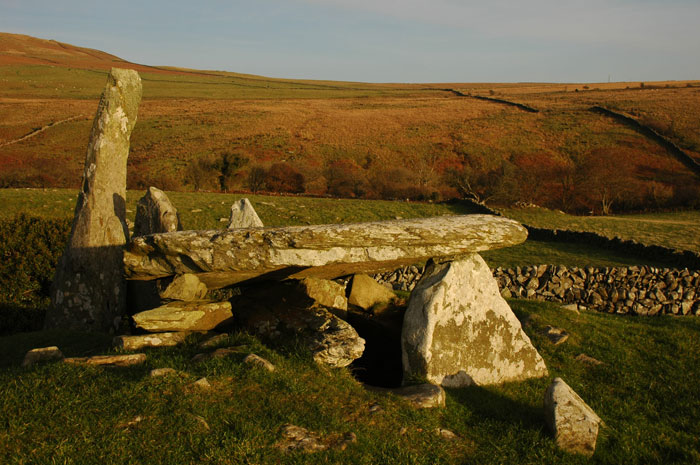
Cairnholy 2 submitted by nicoladidsbury on 18th Nov 2008. Cairn Holy II
Golden Sunlight over Cairn Holy II
(View photo, vote or add a comment)
Log Text: Cairn Holy 2, Dumfries and Galloway: From Cairn Holy 1, there is a gate in the stone wall leading up to this monument. In the field to the left of this footpath there is the remains of another possible cairn.
I found Cairn Holy 2 more atmospheric that Cairn Holy 1, but the ambience was spoiled by the close proximity of a bungalow and farm buildings (but what a view to have outside your lounge window!).
A smaller, only slightly less spectacular than Pentre Ifan, it is on steeper ground than Cairn Holy 2. The cap stone has two modern holes drilled in, presumably to lift it back into place.
With it now being late afternoon and a hint of dusk starting to fall, we wanted to go onto Anwoth to find the Holy Well and visit Trusty’s Hill.
In the hour we spent at Cairn Holy 1 and 2 we only saw one other couple walking a dog. Almost as quiet and empty as Northumberland!
