Contributory members are able to log private notes and comments about each site
Sites Anne T has logged. View this log as a table or view the most recent logs from everyone
Cowclose House (Barningham Moor)
Trip No.117 Entry No.7 Date Added: 12th Feb 2019
Site Type: Ancient Village or Settlement
Country: England (Yorkshire (North))
Visited: Yes on 6th Feb 2019. My rating: Condition 2 Ambience 3 Access 5
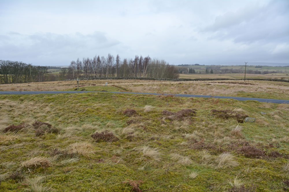
Cowclose House (Barningham Moor) submitted by Anne T on 12th Feb 2019. Standing at the southern side of this unenclosed settlement, looking northwards across it.
(View photo, vote or add a comment)
Log Text: Cowclose House Unenclosed Settlement, Barningham Moor: In some ways, this settlement was much easier to identify on the ground than Grey Stones, just to the south east, as there was a ditch running east-west alongside the southern side of the metalled track, and a clear circular enclosure, which stood out as being bright green, shorter grass on the north side of the road.
Would love to go back with the notes and the plan and look round again.
All Saints Church (Weston)
Date Added: 15th Apr 2015
Site Type: Ancient Cross
Country: England (Yorkshire (North))
Visited: Yes on 31st Mar 2015. My rating: Ambience 5 Access 5

All Saints Church (Weston) submitted by Sunny100 on 24th Aug 2010. B/w image of the 9th-10th century Viking cross fragment in All Saints church. The carving depicts a Viking warrior with his sword and a female figure at his side.
(View photo, vote or add a comment)
Log Text: The Weston Cross - repeat visit with key to church! We picked up the key to the church from The Cock Pit Farm Tea Rooms, which is open from 11am until 4pm (summer hours – very popular with cyclists and great tea-cakes and tea). We were very kindly told that if we were back after 4pm (which we were) to drop the key back through their letter box at the rear of the cafe.
We went to find the remains of the Anglo Saxon cross in the north side of the chancel but found this to be a most unusual and interesting church, well worth the visit. Now Grade 1 listed, the present building dates from the 11th century. Locally called “the little church in the fields” it houses a three tier pulpit, the original box pews, a squire’s parlour and a fragment of 14th century glass. There is also an 18th century sundial (minus its brass top).
On the external north wall of the chancellor remains of a scroll can be seen below the window. Behind the mortar, the stone with this carving looks to be contiguous with the one above which seems to have some very weathered patterns on it. Higher up and to the left of this window are two stones which have squares incised into them.
My next mission will be to visit the Yorkshire Museum to see The Weston Man.
The Weston Cross, All Saints Church, Weston, This higgledy-piggledy, pretty little church, almost a patchwork of stonework from different times and styles, is situated in some impressively pretty countryside. Although I understood the church key was readily available from a cottage nearby, no-one was in, so I've had to email for the contact numbers to telephone when we return to the area in a couple of weeks. Parish Administration tell me there's also a key kept at Cock Pit Farm tea rooms on the
main road (opposite the turning to Weston Church), which is open Wednesday to Sunday, 11am to 4pm during summer. There is a small parking area opposite the gates to the stable yard within a few metres of the church gate, which the owner told us was OK to use whilst looking at the church. I'm really looking forward to going back.
Weston Moor
Date Added: 1st Nov 2017
Site Type: Rock Art
Country: England (Yorkshire (North))
Visited: Yes on 25th Mar 2015. My rating: Condition 4 Ambience 4 Access 4
Weston Moor (541) submitted by rich32 on 27th Nov 2004. ‘Greystone Rock’ Weston Moor, North Yorks SE1843349648
A large rock with 20+ cups, 3 with 3 rings & a few grooves to boot.
This is ref number 541 in Boughey & Vickermans ‘Prehistoric Rock Art of the West Riding’.
(View photo, vote or add a comment)
Log Text: Needs moving to new site page: Weston Moor (Greystone Rock, Boughey & Vickerman 541)) Rock Art: We had fun and games getting to this site from Otley, as the road over the River Wharfe had been shut for roadworks, then the Weston Moor Road was also closed. We managed to park by the stile over the stone wall close to where Moor Road meets Weston Moor Road. The ground was very boggy indeed. We did have to stray a little way from the footpath to find this stone, but a dog walker was already in the field with his golden labrador.
Following the footpath west, we went in search of 'The Spectacles' at SE 1843 4965 but even with a 10 digit grid reference and after almost an hour of walking around the same spot, came to the conclusion it was buried too deeply under the turf, and we weren't going to dig around to find it.
Just north of the footpath from the spot where The Spectacles was supposed to be located, both husband and I thought we spotted what might be a cairn rising some 20 to 30 cms in a circle above the surrounding landscape. Given the number of boulders in the surrounding landscape (most part of larger outcrops) it is probable this might be a clearance cairn. The evening light helped this feature to stand out, and I enjoyed trying to photograph it.
Tree of Life Stone
Date Added: 11th Apr 2015
Site Type: Rock Art
Country: England (Yorkshire (North))
Visited: Yes on 10th Apr 2015. My rating: Condition 4 Ambience 4 Access 4
Tree of Life Stone submitted by DavidRaven on 21st Jul 2003. The Tree of Life stone, looking south east down the Washburn valley.
It lies on the eastern edge of Snowden Carr.
(View photo, vote or add a comment)
Log Text: Tree of Life Rock Art Stone, near Otley: From seeing the remains of the Anglo Saxon cross shaft at All Saints in Weston, we re-joined Moor Lane, turning left to the village of Askwith. This appears to be a ‘rat run’ from Ilkey to Otley, and there are a lot of cars along this very narrow lane, so approach bends with caution! Once in Askwith, we turned right onto Askwith Lane which turns into Moor Road. Continue straight on at the cross roads with Weston Moor Road. We managed to park one field passed the gate to the access land, just passed the entrance to Carr Farm (there is room for one car on the grass verge).
Walking up the hill towards the Tree of Life stone, we admired the outcrops of crop to our right hand side. At the top of the field there is a gate through into the moorland behind it. The Tree of Life stone is about 50 feet west from the corner of the stone wall to your right hand side as you come through this gate. Its full grid reference, taken from our GPS device is SE 17981 51166.
There are splendid views across the Washburn Valley and to the Swinsty Reservoir to the north east, but as we stood the murk from the polluted continental air moving across the UK rolled across slowly and even the mast at Norwood Edge disappeared into this mist.
Continuing along Snowden Carr Road, this lane eventually joins onto Askwith Moor Road with in turn joins with the main A59 towards Harrogate.
Wulfhere's Cross
Date Added: 19th Apr 2015
Site Type: Ancient Cross
Country: England (Yorkshire (North))
Visited: Yes on 17th Apr 2015. My rating: Condition 3 Ambience 4 Access 5
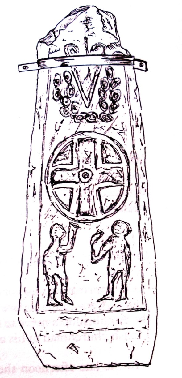
Wulfhere's Cross at Addingham submitted by Sunny100 on 28th May 2010. Wulfhere's Cross at Addingham at SE.085497. Detailed illustration of the 9th-11th century Saxon/Viking cross-shaft.
(View photo, vote or add a comment)
Log Text: Wulfhere's Cross, Addingham, West Yorkshire: After a busy day with an early start and a disappointment getting to rock art sites on Ilkley Moor, this was a great end to a long day.
St. Paul’s is in the prettiest little spot in the small village of Addingham down by the River Wharfe and is in a historically interesting spot. Driving over a small bridge, the lane to the church leads across a field which clearly holds the remains of two fish ponds belonging to the old manor house which used to sit on this site.
We parked near the gate to the church yard in the car park by the church hall. Being 17:40 we weren’t sure if we could get into the church, but the door was open (note: on leaving the church, the door locked behind us and we were unable to get back in – the door must be on an electronic timer which triggers about 18:00 or at dusk). The porch was very dark (the lights didn’t seem to operate in this part of the church) and I cautiously made sure we were able to get back out again!
This building is clearly very ancient – the roof timbers are very old, the church information sheet saying they date from the 1520s or 1530s.
The Anglo Saxon cross sits at the entrance to a side chapel on the south eastern side of the church. Nothing in the church records refer to it as “Wulfhere’s Cross” although it’s named after the Archbishop of York, Wulfhere, who had a residence here at the time the Vikings raided York in AD867. Next to the cross there is a notice on the wall: “Fragment of an Anglo-Saxon Cross: This fragment of the shaft of an Anglo-Saxon cross was uncovered in the churchyard in 1947 during the digging of a trench. The fragment has been examined by experts in Anglo-Saxon sculpture who have dated it to the 10th century and almost certainly prior to 972. The scene on the front is, according to the experts, a representation of the apocalypse. Both sides have scroll carvings. The back is very worn but it is possible to make out carvings which could be vine scrolls. In the churchyard is a cross base dating from the same period.”
Standing by the cross and turning to face the southern wall, I was immediately hit by the size of the internal wall – huge. There was also the fragment of an Anglo-Saxon bone ornament (a comb?) kept in a glass topped case in the book case at the north-west corner of the church. This was almost impossible to photograph because of the light and reflections in the glass (or at least by me at the time!).
The old door to the bell tower in the western wall of the porch was really old and interesting.
Going back to the car I noticed some modern day carving in the wall of the church hall, together with a modern cross shaft.
We didn't look for the cross base in the church yard as it was deep in grass and daffodils and I didn't want to tread these flowers down in my search.
St Mary (Thornton Watlass)
Date Added: 1st Aug 2015
Site Type: Ancient Cross
Country: England (Yorkshire (North))
Visited: Yes on 23rd Jul 2015. My rating: Condition 3 Ambience 3 Access 5
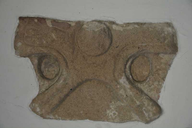
St Mary (Thornton Watlass) submitted by Anne T on 1st Aug 2015. This is the second cross head which is built into the east wall of the porch. It dates from the first half of the tenth century.
(View photo, vote or add a comment)
Log Text: Anglo Saxon Cross Heads, St Mary The Virgin (Thornton Watlass), North Yorkshire: St Mary The Virgin is 3 miles from Bedale and 11 miles from Ripon. It is grade II listed (English Heritage Building ID: 333615), dating largely from the 15th century.
There are two Anglo Saxon cross heads on display in the porch, one on the east wall and one on the west. The church was firmly locked at the time of our visit although the door to the porch was left open. We parked on the small triangle of land at the cross-roads opposite. It was tricky to cross the road as the church lies in the crook of a sharp bend and traffic cannot be seen until the last minute, so cross quickly!
According to the Corpus of Anglo Saxon Stone Sculpture by James Lang (Google books) "The cross head built into the interior east wall of the porch was first noted in 1908 by E. Bogg as being in its present position. Its height is 44.2 cms by 32.8 cms wide and 17 cms deep. Made of fine to medium-grained millstone grit, the right arm of the cross is lost and only one face is visible, and is part of a wheel-head cross with wedge-shaped arms and a ring recessed from the face. Date: first half of 10th century; The cross head in the west wall is 29.5 cms high, 48 cms wide (no depth recorded as it is built into the wall). The upper limb of the cross is lost; only one face is visible. Part of a plate-headed wheel cross, the rim raised and recessed from the face. A plain edge moulding follows the perimeter of the cross ... the lower limb of the cross has a curved incision which creates the impression at the sides of heavily stylised legs for a Crucifixion; conversely it could be the arris of a plain panel. The lateral arms are filled by hands with a wrist band and three huge fingers. In the centre of the cross is a large boss. Date: first half of the tenth century."
I admit to not being able to see the crucifixion scene described by James Lang in the Corpus of Anglo-Saxon Stone Sculpture (Google books) until I rotated my photograph by 90 degrees!
St Mary (Wath)
Date Added: 1st Aug 2015
Site Type: Ancient Cross
Country: England (Yorkshire (North))
Visited: Yes on 23rd Jul 2015. My rating: Condition 3 Ambience 3 Access 5
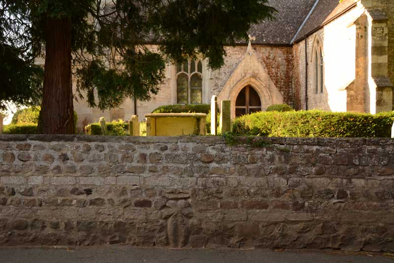
St Mary (Wath) submitted by Anne T on 1st Aug 2015. As the church was locked at the time of our visit, this is the only cross we could find, in the exterior church wall, almost in line with the porch in the south wall of the church.
(View photo, vote or add a comment)
Log Text: Anglo Saxon Cross, St. Mary's Church, Wath: Situated on a bend in Main Street, Wath, this church is in a pretty little village. We parked outside the main gate of the church (there is just room for one car to sit here, as someone else’s gates are immediately adjacent). We eventually found the cross in the exterior of the church wall, in line with the porch in the south wall of the church. There are only narrow pavements running alongside; the size of the lorries that rumble through making taking photographs of this cross precarious, to say the least. Andrew watched both sides of the bend to ensure I wasn’t going to get run over when I took a photograph from the middle of the road.
I found a document by Harrogate Council which told me a little more about the church and village: Wath is the Old Norse term meaning ‘ford’ and is mentioned in the Domesday Book of 1086. There are parts of the church that are very old indeed, and the above booklet mentions “The only built fabric from around this time are the remains of Saxon sculptures in the organ chamber of the present St Mary’s Church and the stone cross embedded into the church boundary wall.” The church was locked at the time of our visit (which was after 6pm) so we couldn’t get into see these. There was an old sundial in the churchyard, just south of the porch. The booklet goes onto say that Wath was essentially the estate village to Norton Conyers, and “St Mary’s Church is the oldest building in the village. It dates primarily from the thirteenth century with additions and enlargement in the fifteenth century and a tower of 1812. It might have originally been a manorial chapel which was rebuilt as a parish church in the twelfth or thirteenth century. The next oldest building in the village is the Rectory, which dates from the sixteenth century and was probably built on the site of its predecessor.”
St Mary (Masham)
Date Added: 1st Aug 2015
Site Type: Ancient Cross
Country: England (Yorkshire (North))
Visited: Yes on 23rd Jul 2015. My rating: Condition 3 Ambience 4 Access 5
St Mary (Masham) submitted by rogerkread on 22nd Oct 2013. The splendid Masham cross pillar, in the rain (as usual when I'm taking photos for the Megalithic Portal!).
(View photo, vote or add a comment)
Log Text: Four Anglo Saxon Crosses in the church of St. Mary The Virgin, Masham, North Yorkshire: After seeing the Anglo-Danish and Anglo-Saxon crosses at both East Hauxley and Wath, we went into Masham to get some lunch. Having visited here twice before, we’d never ventured into the church here (either having been with some disinterested visitors or at the end of an already long day), although I vaguely knew there were some Anglo Saxon crosses here.
The base of the large sandstone cross shaft cannot be missed and stands in the churchyard near the porch and dates from the early ninth century. The church guide states that "recent research has linked it stylistically with a broken cross shaft of similar date now at Cundall and Aldborough.” The panels on this cross shaft are very worn, and the top is capped with an ugly lead cap, presumably to stop further weathering. The text in the church and the church guide book told us that the incomplete top panels almost certainly represent Christ and his Apostles; the second and third panels contain scenes from the Old Testament.
Inside the church are three other cross shafts, two hidden conveniently in an alcove in the wall in the south aisle, behind the votive candle table, which we moved to take photographs, and carefully placed back. Exploring some medieval grave markers next to these, we came across another fragment of cross shaft with a notice next to it telling us it was from the late 8th/early 9th century. This fragment was very plain with only edge moulding visible on one edge.
St Wilfrid's Holy Well
Date Added: 1st Aug 2015
Site Type: Holy Well or Sacred Spring
Country: England (Yorkshire (North))
Visited: Yes on 23rd Jul 2015. My rating: Condition 3 Ambience 3 Access 5
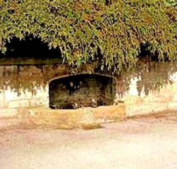
St Wilfrid's Holy Well submitted by Sunny100 on 8th Jun 2010. St Wilfrid's Holy Well at Ripon, N.Yorks. SE.309710.
(View photo, vote or add a comment)
Log Text: St. Wilfrid's Holy Well, Skellgate Road, Ripon: Armed with only a 6 digit grid reference and a GPS device that was rapidly running out of battery, this well took some finding, but in the end we did. St. Wilfrid’s Well is located at the north side of the B6265, some 700 metres west of the city centre, where Skellbank Road becomes Mallorie Park Drive. A few yards east of the well are some steps leading up to Ripon Spa Gardens. The 8 digit grid reference is SE 3085 7102.
The well is located within a stone wall, almost overhung by bushes from the bank above. At the time of our visit there was no water trickling into the well at all. Someone seems to care for it, for there was no litter in or around it.
St Wilfrid is the patron saint of Ripon (the crypt at Ripon Cathedral is purported to be part of his early church, although I’ve yet to verify this). The St Wilfrid’s Day parade takes place on the Saturday before the first Monday of August each year (this year it happens to be 1st August (2015)) in which an actor takes the part of St. Wilfrid. The procession now centres around the Market Square, starting at Studley Road, then Westgate, Market Place West, North Street, North Road, Magdalens Road, Stonebridgegate, Allhallowgate, Market Place East, Kirkgate, Bedern Bank, Bondgate, Southgate, Barefoot Street, Harrogate Road, High Skellgate, Westgate, Blossomgate, Marshall Way, North Street, Market Place East, Kirkgate, ending at Ripon Cathedral.
Worth stopping to look if you are passing by this well.
Ripon Cathedral
Date Added: 7th Sep 2015
Site Type: Ancient Cross
Country: England (Yorkshire (North))
Visited: Yes on 5th Sep 2015. My rating: Condition 3 Access 5
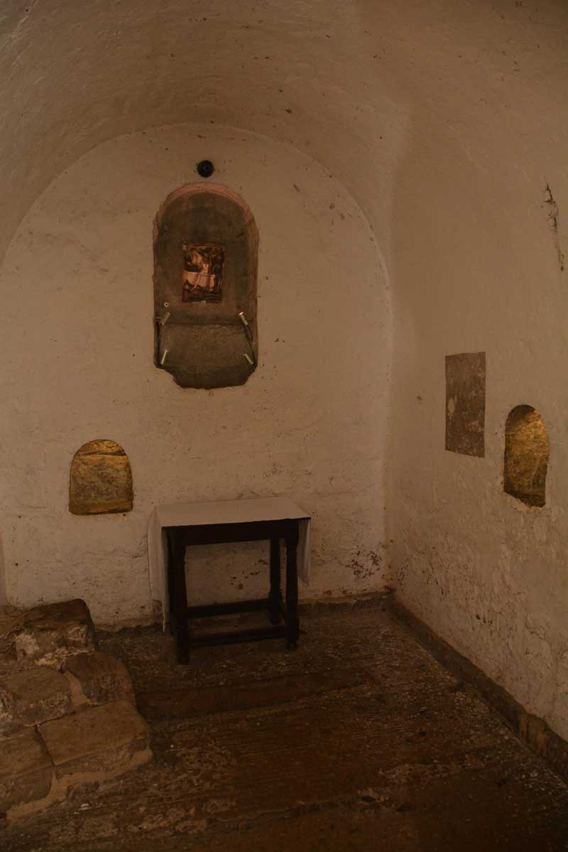
Ripon Cathedral submitted by Anne T on 3rd Aug 2015. This is the Anglo Saxon crypt at Ripon Cathedral, which is said to be part of St. Wilfrid's original 7th century church on this site. It has been white-washed since I visited 3 years ago. No sign of the Anglo Saxon cross fragments we were told might be down here, but very interesting never-the-less.
(View photo, vote or add a comment)
Log Text: Anglo Saxon Stones, Ripon Cathedral: Visit by arrangement with the Head Verger, 5th September 2015.
I'd made enquiries about the Anglo Saxon stones and received the following reply: "There is in fact little at Ripon by way of sculptured remains from the Anglo Saxon period. Clearly the Crypt itself is entirely Anglo Saxon, but there are no carvings here and some at least of the stones are Roman in origin. What remains otherwise are two stones built into the outer wall of the North Transept which are said to have come from Wilfrid’s 7th Century church. They have distinctive Celtic interlaced patterns. Also, in the Chapel of the Resurrection below the Chapter House there is a substantial drumstone which was one of two discovered in the 1990s under the tower. They are thought to be column bases from Wilfrid’s church. They are shaped with three stepped bands, but otherwise not decorated. One remains where it was found, the other now serves as an altar stone in the Chapel. (I wonder if these are the ‘imposts’ you have heard about?) The Chapel is not normally accessible, but it might be possible to arrange with a verger to see it.
The other early piece of stonework is the Sigurd Stone which is part of a stone cross which bears the image of the legend of Sigurd who was a Norse hero who sucked his thumb after a burning encounter with a dragon - though there are various interpretations of the story. The representation of this story on a Christian cross is of course remarkable, but this may not be of so much interest as it probably comes from a slightly later period. The stone fragment itself is currently in store."
In fact the Sigurd stone was largely obscured by staging, which hadn't been removed, so the verger on duty had to bring a torch to illuminate the three fragments, and I had to move fire extinguishers and clamber on top of staging to be able to see it at all. What a shame - this is a fantastic example of Anglo-Scandinavian carving. The verger also took me down to the Resurrection Chapel to see the large drumstone which now forms the altar; then we dived across into the north aisle to another small chapel to see another drumstone, worked into a font in the distant past but now topped with a modern circular mirror. We then went outside to see the stones in the external wall of the north transept (west end), then to the south nave where we'd spotted what looked like the remains of an ancient preaching cross (which I've also enquired about - yet to see a reply).
The cathedral was exceptionally busy, with the Great North Art Show being on, and the Northern Philharmonic Orchestra rehearsing for a concert that evening. Well worth going! Many thanks to the vergers for their time and patience.
First visit, 28th August 2015: Anglo Saxon Stones at Ripon Cathedral: I was intrigued by this page on the Portal, as I've been to several events here and not noticed any Anglo Saxon cross fragments , so when passing through decided to stop and have a look.
We were greeted by a guide and asked him if he knew of the whereabouts of any Anglo Saxon stones or sculptures and were told they were probably down in the Anglo Saxon Crypt. I also had to pay £3 in order to take photographs within the Cathedral.
The crypt has been white-washed since I last saw it (which is probably how it would have been in Anglo Saxon times) and this somewhat spoiled the ambience for me. There was a piece of wall left in its original condition, and you could see the remains of well worn scratches (possible runes and a small dedication cross?). I wasn't convinced this is what I was looking for.
Since coming home, I've researched what this stone(s) might be and found reference to a 'roman-looking' carved pillar and some imposts on the Corpus of Anglo Saxon Stone Sculpture web site. We certainly didn't find these, although we had a good scout round. I have since sent off an email to one of the senior admin team at the Cathedral, and will report back when I get a reply.
All Saints (Ingleby Arncliffe)
Date Added: 29th Apr 2017
Site Type: Ancient Cross
Country: England (Yorkshire (North))
Visited: Yes on 28th Jul 2015. My rating: Condition 3 Ambience 3 Access 5
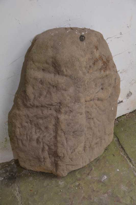
All Saints (Ingleby Arncliffe) submitted by Anne T on 4th Aug 2015. This is the cross which can be found leaning against the north wall of the porch of All Saints, Ingleby Arncliffe. The porch is at the base of the tower.
(View photo, vote or add a comment)
Log Text: Ancient Cross, All Saints Ingleby Arncliffe, North Yorkshire: All Saints at Ingleby Arncliffe is very close to the A19 so we thought we’d stop off on the way back home, but finding this church was quite interesting – we had three unsuccessful attempts, driving down different roads from the centre of the village of Ingleby Cross. In the end, I got the GPS out and found the church straight away. The church is located about a quarter of a mile to the south-east of Ingleby Cross village, having to cross the A172 to reach it. From the cross roads the church is approx. 200 yards to the right hand side with a small parking area by the main gate to the churchyard.
The church many now be really distant from the village, but is right next to the manor house which dominates the view of the churchyard. The church itself was (not surprisingly for the early evening) locked, but we could gain access to the porch which is in the lower part of the tower. There was a cross (very similar to the one at Wath) leaning up against the north wall. We walked right around the building twice but could see no other crosses/old stone fragments built into the fabric of the building. There are supposed to be two more stones built into the tower along with another in the vestry according to the Yorkshire Moors Gazetter. The entry for Ingleby Arncliffe on the British History site says “A hog-back stone found about fifty years ago in a hedge bank and a later coped gravestone are now in the Cathedral Library.”
We peered through the windows of the church, and it appears to be all original box pews with a three-tier pulpit. I have sent an email to the vicar, through the ‘A Church Near You’ web site, asking if it’s possible to pick up a key next week to get inside the church and also see if we can find the stones in the tower.
All Saints (Northallerton)
Date Added: 4th Aug 2015
Site Type: Ancient Cross
Country: England (Yorkshire (North))
Visited: Yes on 28th Jul 2015. My rating: Condition 3 Ambience 4 Access 5

All Saints (Northallerton) submitted by Anne T on 4th Aug 2015. This wonderful cross head sits on the step at the north western corner of the quire.
(View photo, vote or add a comment)
Log Text: Anglo Danish cross fragments, All Saints Church, Northallerton, North Yorkshire: I found the exterior of All Saints in Northallerton, which sits at the northern end of the High Street on the A167, very forbidding with its blackened stones. However, the inside was nice enough, although very Victorian, and we were made very welcome by a parishioner who had popped in to collect the church magazine. I had to chuckle as the “A Brief Guide to All Saints Parish Church” which says the oldest thing in the church is the Norman grave cover (to be found at the northern eastern corner of the nave). They have ignored the Anglo Saxon (or they correctly call it in this part of the world, Anglo Danish) stones on the window ledges.
The guide book says that there was supposed to be a church of stone built here in the early 7th century by St. Paulinus. “Fragments of stone crosses, possibly of this period, still exist, some built into the walls at various places, while a very fine cross head and separate shaft are on permanent loan to Bede’s World ..... although there is no visual evidence to suggest a significant stone building before the 11th century.” For the picture of the Northallerton Cross at Bede’s world, follow the link http://www.megalithic.co.uk/modules.php?op=modload&name=a312&file=index&do=showpic&pid=133724.
All the crosses, apart from one, which is at the south eastern corner of the choir, sit on window-ledges, most along the north wall and north transept, but some in the small kitchen area at the west end of the north transept. Most remarkable is the fragment with what looks like a sheep.
I’ve had difficulty in finding out more about these stone fragments, although the Corpus of Anglo Saxon Stone Sculpture web site says the North Yorkshire collection will be on-line soon.
Funnily enough, the church guide prides itself on the Robert Mouseman mice on the wooden furniture, and there is a special “Mouse Guide To All Saints Parish Church Northallerton.”
All Saints (Kirby Hill)
Date Added: 4th Aug 2015
Site Type: Ancient Cross
Country: England (Yorkshire (North))
Visited: Yes on 28th Jul 2015. My rating: Condition 3 Ambience 5 Access 5
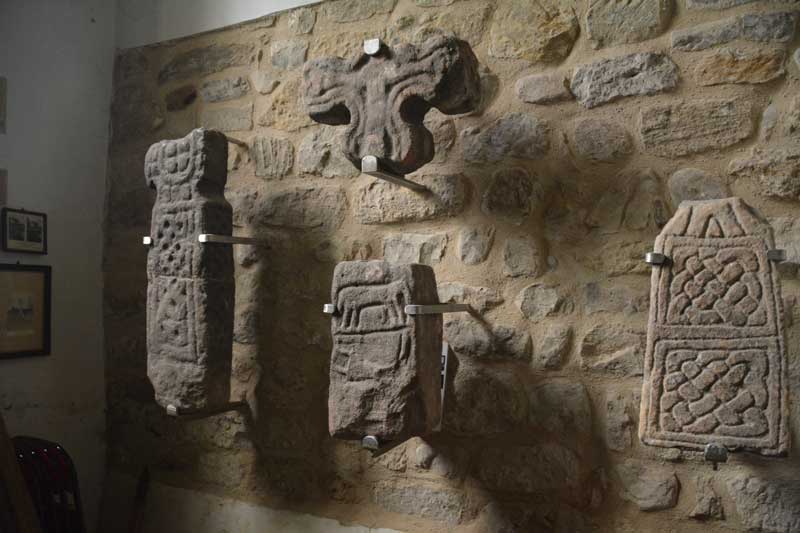
All Saints (Kirby Hill) submitted by Anne T on 4th Aug 2015. These are the Anglo Saxon cross shafts, cross head and an early grave marker displayed on the north wall of the tower.
(View photo, vote or add a comment)
Log Text: Anglo Saxon Crosses, Kirby on the Moor (Kirby Hill), North Yorkshire: All Saints sits on a green just outside the village of Kirby on the Moor, between Church Lane and Millings Lane. There was a notice near the entrance gate saying the church was open on Sundays between 2pm and 4.30pm and ‘all welcome’. However there was a car parked by the church gate and we could hear someone playing the organ. Entering cautiously, I asked if it was OK if we could look around, and the gentleman nodded. He was clearly practicing a piece over and over and I felt we were distracting him somewhat. He had lit the area around the organ, but no lights were on in the church, so it became a bit difficult see the crosses into the interior church walls as I kept having to fire the flash to see. We thanked him and escaped.
The majority of the crosses are displayed in the north wall of the tower, next to the font, so it’s a bit difficult to get great photos as the space is so small. There was a leaflet about the Anglo Saxon stone sculptures that was really helpful.
I’ve just found their web site, All Saints Kirby Hill, which is great. The church is grade 1 listed, the nave being part late Saxon/early Norman, built with large irregular stones including carved slabs and cross shafts of Saxon origin. The web site tells me that the site is one mile north of Boroughbridge, the church is also known as Kirby Hill, and is at the highest point of the village, in line with Aldborough (the Roman civil capital Isurium Brigantum) and other probable sites of the Roman crossings of the River Ure.and is probably on the site of much earlier shrines dating back to Roman or even Celtic times.
Robin Hood's Well ( Yorkshire)
Date Added: 8th Sep 2015
Site Type: Holy Well or Sacred Spring
Country: England (Yorkshire (North))
Visited: Yes on 5th Sep 2015. My rating: Condition 4 Ambience 3 Access 3
Robin Hood's Well ( Yorkshire) submitted by HOLYWELL on 16th May 2010. A Victorian fancy or pagan site? More likely the other as Robert James Culverwell in his
"The Enjoyment of Life; or Health, Recreation and Rational use of Time, 1850" notes:
Yet for awhile let gay fancy beguile us with merry visions of the past. On this glade, the Curtal Friar of Fountains encountered Robin Hood, whom at length he threw into the Skell and, afterwards, fought to his heart's content. Then whistled out so many of his good ban dogs; but Little John let his arrows fly among them ...
(View photo, vote or add a comment)
Log Text: Robin Hood's Well at Fountain's Abbey, North Yorkshire: After our visit to Ripon Cathedral to see the Anglo Saxon/Pre-Norman stones, we took our small grand-daughter over to Fountains Abbey to enjoy the sunshine in a beautiful location. Walking past the Abbey to Studley Royal Water Gardens, we retraced our steps on the opposite side of the River Skell to the Abbey ruins. I'd spotted this structure on the walk down and said "that looks like a well". When we went past it on the return leg of our walk, it was indeed a well, although dry. It wasn't until I got back and checked on the Portal that I found out it was "Robin Hood's Well."
The stones on the left hand side, as you face the well, look as if they are being undermined by the wear on the track that leads up past it to the woods, but comparing the photographs submitted in 2010, it hasn't changed much.
Peering inside the well, there is a stone channel on the left hand side at the top/back of the well which routes water (if there is any) into the basin at the bottom.
Thimbleby Nine Stones
Trip No.2 Entry No.1 Date Added: 9th Oct 2019
Site Type: Standing Stones
Country: England (Yorkshire (North))
Visited: Yes on 9th Jun 2016. My rating: Condition 3 Ambience 4 Access 3
Thimbleby Nine Stones submitted by SolarMegalith on 15th Mar 2013. Northern pair of standing stones - view from the south (photo taken on March 2013).
(View photo, vote or add a comment)
Log Text: Nine Stones Stone Row, near Osmotherley, North Yorkshire: Having added a few of the Stone Rows of Great Britain sites on the Portal, and needing to go down to Thirsk it was too much of a temptation to resist visiting one or two of the North Yorkshire sites. With only a 3 hour window before having to travel onto Doncaster, the only one we could reach and explore in time was Nine Stones, just outside Osmotherley.
We’ve been to this area before to look at Anglo Saxon crosses in churches and ended up getting hopelessly lost, but this time we had the OS map and our GPS. With the sun shining down from an almost cloudless sky, we reached the car park at Square Corner easily enough. It never ceases to amaze me that there are so many more people in this part of the world than in Northumberland. There were people picnicking on the side of the road near Solomon's Temple enjoying a wonderful view over Oak Dale valley and the woods of Crabtree Bank and Thimbleby Bank Plantations.
As we pulled up, a number of dog walkers drew up, chattering noisily, and I hoped they weren’t going to follow us and destroy the peace and quiet of the afternoon (I’m definitely getting to be a grumpy old woman!). Fortunately, they followed the Cleveland Way up the hill to the south.
From the car park, we walked the couple of hundred metres to the gate where the footpath west over Thimbleby Moor and the Cleveland Way southwards meet. The GPS told us there was almost 700 metres to walk to Nine Stones, so we set off over the stile over the wall by a second gate to the west. The first couple of hundred yards were easy walking along a stoned footpath leading off to some modern shooting butts to the west. After 200 metres we needed to veer off southwards to follow the dry stone wall westwards. This was all through knee deep heather with the occasional field drain and boggy patch thrown in. After another 200 yards we realised we’d reached a much quarried area; there were deep holes full of water which we could only see when we were almost upon them. I managed to disappear up to my ankles in one, although there were other that looked far deeper.
Whilst the area has many blocks of stone poking up through the heather, towards the top of the slope there suddenly appeared on the horizon two standing stones, looming large, beckoning the walker. Here was (were?) Nine Stones, at last.
This stone row was well worth the trudge through the undergrowth. At the northern tip of the row there are five stones, two tall, two stumpy and one almost buried in the heather. We wondered which were actually part of the stone row. The north-western most stone looked as if there had been an attempt to quarry the top of it in the distant past (comparing the holes to some at Edges Green, near Cawfields) that we’ve seen recently.
Two more tall stones sit close to the stone wall, and a few more stones appear further south in the forested area. The Stone Rows of Great Britain site tell us that this stone row is 60 metres long, but husband, tramping through the forest, thought it might be possible that the row was nearer to 100 metres (but then which are natural stones and which are recumbent standing stones?).
There are so many other features in this area to explore: Miley Pike Tumulus, Robinson’s Cross (remains of), a Holy Well, Faber’s Stone – well worth a repeat visit.
Mauley Cross
Trip No.7 Entry No.1 Date Added: 2nd Oct 2016
Site Type: Ancient Cross
Country: England (Yorkshire (North))
Visited: Yes on 1st Oct 2016
Mauley Cross submitted by vagabondnma on 13th Mar 2007. Mauley Cross standing on a raised area of land by the forest road backed by a plantation.
(View photo, vote or add a comment)
Log Text: Mauley Cross, north of Stape, North Yorkshire: Chrispy's directions were spot on - thanks! Trust us to arrive on the day of a rally, with all the cars coming in the opposite direction. Being off-stage, they needed to stick to the speed limit and we found ourselves constantly pulling in to passing places. It was fun to see the different cars.
Arriving at the junction of the metalled road (Keys Beck Road) which runs north through Stape then up over the moors and the forest track (Brown Howe Road) we came across ‘road closed 1st October 2016 due to the Trackrod Rally). There were some marshalls sitting at the wide entrance to this forest track, so we parked between their cars and wandered 50 metres or so up the track to find this cross, making sure to avoid the rally cars which zoomed down every minute or so. After a few minutes a doctor's car zoomed up the track past us and we took advantage of a lull in the stream of cars (there must have been an accident - hope everyone was OK).
Sitting a couple of metres off the forest track, the grass around the cross has been cleared and a couple of tributes sit at its base.
There are two Mauley Crosses listed on the ADS database, the second being just east of Saltergate (this is a similar cross, made out of one piece of sandstone, forming a boundary marker between the parishes of Allerston and Lockton at grid reference SE86679493.
Old Wives' Well
Trip No.7 Entry No.2 Date Added: 2nd Oct 2016
Site Type: Holy Well or Sacred Spring
Country: England (Yorkshire (North))
Visited: Yes on 1st Oct 2016. My rating: Condition 3 Ambience 4 Access 5
Old Wives' Well submitted by vagabondnma on 13th Mar 2007. A close-up of the well. The inscription (grafitti?) on the capstone is not easily visible).
(View photo, vote or add a comment)
Log Text: Old Wives' Well, just south of Mauley Cross, near Stape, North Yorkshire: With this well only 223 metres south of the Mauley Cross, we decided to walk down the narrow metalled road ((Keys Beck Road) to the well. Again, Chrispy’s directions were spot on. This time, the rally cars were back, appearing every minute or so and we had to ensure we were visible to the drivers at all times (sometimes difficult with the bracken at the sides of the road being so high). Walking southwards back down towards Stape Village, reaching the first passing place on the left hand side of the road, a small track leads through the grass. About 20-30 metres into the wood we glimpsed a wooden rail which partially surrounds the well, then the well itself came into site.
With a simple stone built ‘hood’ over it, into which there is writing carved into the lintel, this is a very enigmatic spot. The well basin was full of water and a small tickle cut its way through the peat floor of the wood, heading south west down hill towards the road.
There were plenty of old ribbons and scarves (even a sock!) tied to the trees around the well.
According to the Pastscape Record for this monument, number 60532, the lettering on the lintel reads: "Nattie Fonten L M Natalis" (Roman governor of 3 provinces 120AD).
Rawcliffe Howe
Trip No.7 Entry No.3 Date Added: 2nd Oct 2016
Site Type: Cairn
Country: England (Yorkshire (North))
Visited: Yes on 1st Oct 2016. My rating: Condition 2 Ambience 2 Access 5
Rawcliffe Howe submitted by vagabondnma on 13th Mar 2007. Rawcliffe Howe as seen from the road - which allows you to see its profile. Unfortunately the embankment cuts right through it. So some of it is missing.
(View photo, vote or add a comment)
Log Text: Rawcliffe Howe, south of Stape Village, North Yorkshire: No entry exists for Rawcliffe Howe on the ADS, but does on Historic England. From Old Wives’ Well, driving southwards back down through the Village of Stape, we came to a four way cross-roads. Parking in a small layby just as we turned into Low Moor Road, where on the opposite side of the road a footpath runs through the wood leading to Rawcliffe Banks. I used the photographs from the mobile Portal site to help locate this.
This round barrow sits right on the edge of the road opposite the entrance to Low Moor Road and has clearly been cut through by the road. Trying to photograph it was very tricky as the rally cars were coming in groups thick and fast, and at one point I jumped further onto the verge to avoid a car that nearly missed the turning!
We managed to get photographs from various angles, although if I hadn’t known this was a site from the Portal would have missed it entirely.
Black Howe (Rawcliffe)
Trip No.7 Entry No.4 Date Added: 2nd Oct 2016
Site Type: Cairn
Country: England (Yorkshire (North))
Visited: Yes on 1st Oct 2016. My rating: Condition 2 Ambience 2 Access 5
Black Howe (Rawcliffe) submitted by vagabondnma on 13th Mar 2007. The bracken covered Black Howe. I have another picture that is even less clear!
(View photo, vote or add a comment)
Log Text: Black Howe round barrow, west of Newton-on-Rawcliffe, North Yorkshire: Just 800 metres from Rawcliffe Howe, travelling east along Rawcliffe Road, Black Howe round barrow can be found.
There is a small layby (which says no parking) but was large enough for several cars, so we parked and hopped out to look.
The barrow was visible as a mound through the bracken, but the farmer had blocked the entrance to the field with harvesting machinery, so it was not possible to access the site to see the barrow from the other side (sadly). There were great views across the Pickering valley.
The only information I can (currently) find out about this barrow is from the Ancient Monuments website, which says: "Traces of an earthwork were noted in the field west of Black Howe in 1949. Field investigation in 1974 found no trace of the feature, the field under pasture", although there is a clear, bracken covered mound at the edge of the field.
St Hilda (Ellerburn)
Trip No.7 Entry No.5 Date Added: 2nd Oct 2016
Site Type: Ancient Cross
Country: England (Yorkshire (North))
Visited: Yes on 1st Oct 2016. My rating: Condition 3 Ambience 4 Access 5
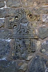
St Hilda (Ellerburn) submitted by kelpie on 24th May 2007. Decorative cross fragment
(View photo, vote or add a comment)
Log Text: Anglo Saxon Cross parts at St. Hilda's Church, Ellerburn, North Yorkshire: From Black Howe, with the light rapidly fading, we decided to go to St Hilda’s in Ellerburn. The Corpus of Anglo Saxon Stone Sculpture has added York and East Yorkshire to their catalogue, and I was able to pull all up the Ellerburn pages on my phone prior to visiting. Sadly, there was no signal in the village so it wasn't possible to view them whilst at the location.
Ellerburn is a very pretty hamlet and the church of St Hilda’s looks like an old manor house that has been converted into a church. Pulling into the layby by the church, there were signs asking for a £3 parking fee (but free if visiting the church).
Entering the churchyard through a lych gate, three sheep were cropping the grass. A stile led from near the path into the churchyard (the gate was padlocked) – to be used at your own risk, the sign said. Sadly, the church was already locked up when we arrived (well it was 6pm) so we missed the stones inside. However, we were able to wander round and pick out the cross parts built into the walls.
The Corpus lists nine stones, 9a and 9b of which are the edges of two hog-back tombs. We wandered up the pretty little stream running opposite the church. A noisy campsite at the farm opposite spoiled the peace of the hamlet, but it was still very pretty and worth visiting.
Wandering around the graveyard, I spotted the grave of Isaac Newton and his wife Mary (no, not the famous one, but still made me smile).
Note: the church site says the church is only open between 10am and 4pm each day.
