Contributory members are able to log private notes and comments about each site
Sites Anne T has logged. View this log as a table or view the most recent logs from everyone
Ardachearanbeg Standing Stone
Trip No.48 Entry No.3 Date Added: 5th Oct 2017
Site Type: Standing Stone (Menhir)
Country: Scotland (Cowal)
Visited: Yes on 21st Sep 2017. My rating: Condition -1 Ambience 4 Access 4
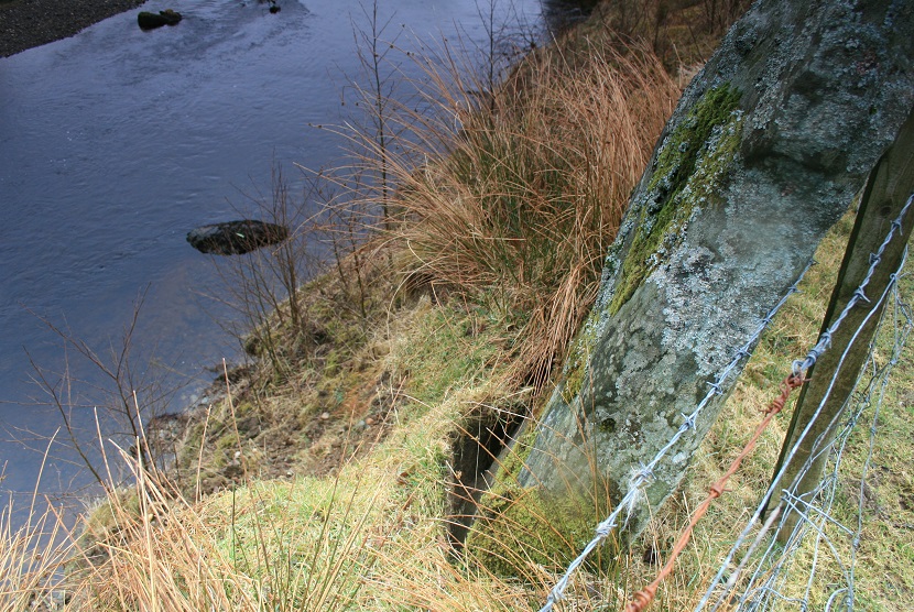
Ardachearanbeg Standing Stone submitted by postman on 7th May 2013. This was three years ago, I wouldn't take the bet its still there.
(View photo, vote or add a comment)
Log Text: Ardachearanbeg Standing Stone, Argyll: Hunted all along the fence line, peering into the river and along the banks for around 100 metres each side of the grid reference and couldn’t find this stone. There was no phone signal, so wasn’t able to call up the Canmore record to double check. Later found out (see below) it has fallen into the river, although we had a pretty good check, looking through the trees and in the river itself, for about 100 metres each way from the grid reference. The river was higher than normal due to all the rain in this part of the world.
Access into the field was from a gate along a small lane just west of the A886 leading to two farms/holiday cottages. There is a small layby at NS 00298 86038 at the junction to these lanes. The field slopes down to the River Ruel. Wellies are advised, as the field was pretty boggy at the time of our visit.
Arthur's Stone
Trip No.168 Entry No.2 Date Added: 28th Jul 2021
Site Type: Chambered Tomb
Country: England (Herefordshire)
Visited: Yes on 13th Jul 2021. My rating: Condition 3 Ambience 4 Access 4
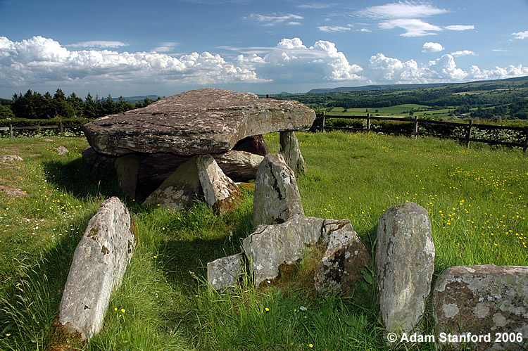
Arthur's Stone submitted by Adam Stanford on 21st Jul 2006. Taken during recent work to investigate the full extent of the covering mound for this monument. Cheers AS.
(View photo, vote or add a comment)
Log Text: Arthur's Stone: This was a really weird visit. No sooner had we parked in the small layby next to the stone's enclosure, and I'd started to take photographs, than a lady walked along the lane, right into the enclosure, sat down and started to have a picnic, so she was prominent in all the photographs. I was absolutely gobsmacked!
I plucked up the courage to ask her to move whilst I finished taking photographs, which she very kindly (but reluctantly) did, to the railing of the enclosure. Feeling somewhat guilty, I started talking to her, and it turned out she was an archaeologist who had come up to join a party of university students in a dig. A pleasant enough chat, but left me feeling uneasy that people would act that this (but then perhaps that's just me), and sort of ruined the visit for me.
Asfordby Cross
Trip No.121 Entry No.2 Date Added: 19th Mar 2019
Site Type: Ancient Cross
Country: England (Leicestershire and Rutland)
Visited: Yes on 17th Mar 2019. My rating: Condition 3 Ambience 3 Access 5
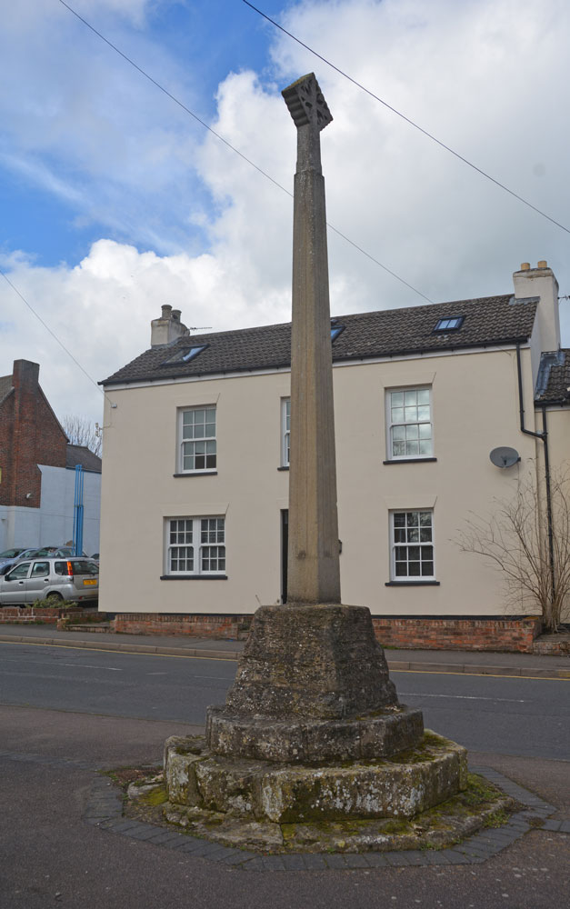
Asfordby Cross submitted by Anne T on 19th Mar 2019. Village Cross in Leicestershire and Rutland England. Standing at the south side of Main Street, where it joins Church Lane, looking north across the cross. The cross shaft and cross are very obviously modern, although the socket stone and steps look much older (although Pastscape says these are not original).
(View photo, vote or add a comment)
Log Text: Asfordby Village Cross: Not really much to see, as the cross shaft is obviously modern, on an older base, but as this was just round the corner from All Saints, we whizzed round to take a very quick look.
Askerton Park
Trip No.69 Entry No.1 Date Added: 5th May 2018
Site Type: Ancient Village or Settlement
Country: England (Cumbria)
Visited: Yes on 23rd Apr 2018. My rating: Condition 2 Ambience 3 Access 4
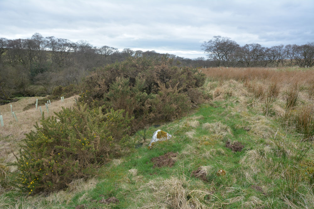
Askerton Park submitted by Anne T on 5th May 2018. Right in the middle of the settlement and just a little to its eastern side, there is a wide stoney bank which looks as if this may have been part of the main dwelling described in the Pastscape record. All around here the moles had been very active, and many shards of pottery had come to the surface.
(View photo, vote or add a comment)
Log Text: Askerton Park Settlement: This is marked on the OS map, so we stopped at the northern end of Parkgate Bridge, where there is room to pull off the road and put on our wellies. We let ourselves in through the gate and tramped over the fields, entering the settlement from its north eastern side.
This settlement is fascinating, as its basically on a promontory between the Cam Back and Melefarm beck. Hollow ways run from the eastern part of the settlement to the Cam Beck, and there is another hollow way which picks up almost half way across the settlement, leading to Cam Beck. Following the latter trackway to the burn, there are the obvious remains of a cairn.
It was really interesting walking across the tops of the enclosure banks, which stood out a brighter green with shorter grass than the surrounding wheat-coloured taller stalks. There were lots of stones in the banks. The moles had had a field day, and I picked up a couple of the many pieces of pottery that had come to the surface of a mole hill (I wasn't certain they were pots until I got home and saw the inclusions and felt the lightness of the pot as opposed to some odd shaped stones).
Askham Fell Cairn Stone Row
Trip No.173 Entry No.4 Date Added: 16th May 2022
Site Type: Stone Row / Alignment
Country: England (Cumbria)
Visited: Yes on 14th May 2022. My rating: Condition 3 Ambience 4 Access 4
Askham Fell Cairn Stone Row submitted by SandyG on 7th Jan 2018. The two western stones and nearby kerbed cairn. View from south (Scale 1m).
(View photo, vote or add a comment)
Log Text: Askham Fell Cairn and stone row: Using M. Waistell Taylor's Antiquarian paper from 1885, plus Sandy Gerrard's notes from the Stone Rows of Great Britain, we parked at the end of a row of cars at the junction of the single track road and the footpath which runs across it, near the Cop Stone. We set off with our trusty GPS to walk up to this amazing cairn to find the associated stone row.
We've visited this area before (28th June 2014), but more recently, Sandy G has been along to this area and surveyed the 2 verified stone rows in this area. We were unable to join him on this survey, but we're curious to find out more.
Thankfully we had Sandy G's diagram of the 4 small stones in this row (I thought they were just part of the kerb). Andrew very gracefully modelled the location of the smaller 2 stones using my walking poles.
Given the number of walkers around, I was amazed how many people were sticking to the paths and bridleways, rather than look at the archaeology. So much to see in such a concentrated area.
Askrigg Cross
Trip No.144 Entry No.6 Date Added: 13th Aug 2019
Site Type: Ancient Cross
Country: England (Yorkshire (North))
Visited: Yes on 8th Aug 2019. My rating: Condition 3 Ambience 3 Access 5
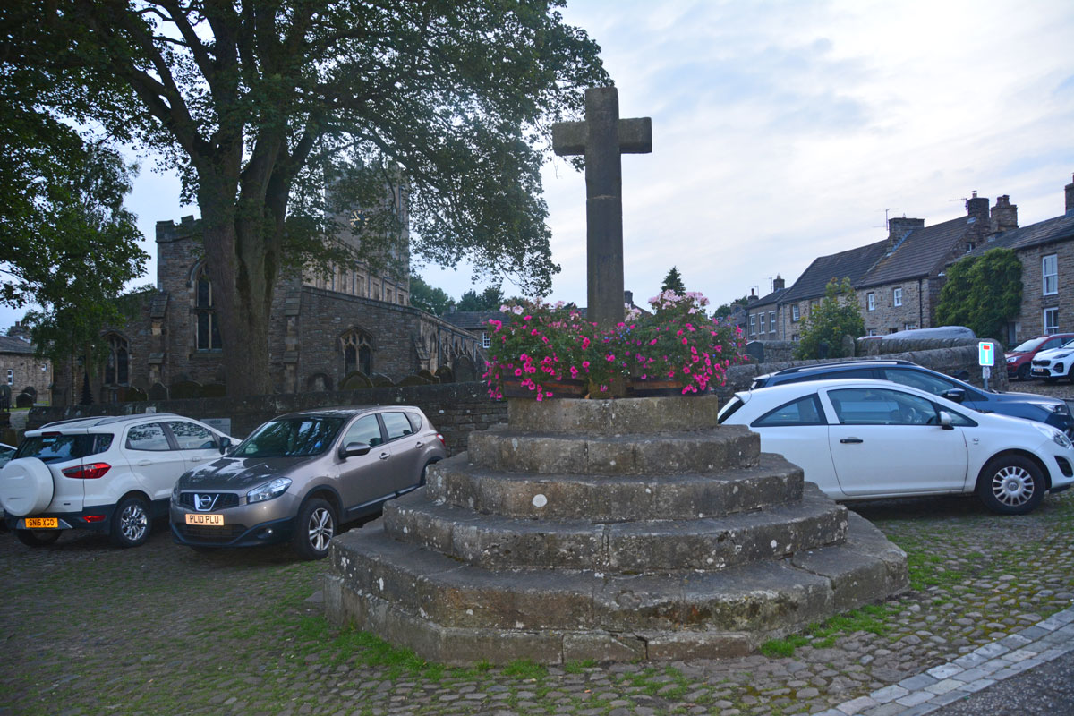
Askrigg Cross submitted by Anne T on 13th Aug 2019. The market cross, looking west towards the church in Askrigg. The shaft dates from 1830, but the steps are 16th century, possibly earlier. Picture taken as dusk was rapidly falling, so not brilliant!
(View photo, vote or add a comment)
Log Text: Askrigg Market Cross and Water Pump: It was dusk by the time we arrived back in Askrigg, and just as I started to take photographs, a large Tesco ‘click and collect’ van pulled up right next to the cross. Typical. With all the cars parked around what must have been the old village green, it wasn't a brilliant spot to linger.
Aspers Field
Date Added: 1st Jul 2014
Site Type: Standing Stone (Menhir)
Country: England (Cumbria)
Visited: Yes on 28th Jun 2014. My rating: Condition 4 Ambience 4 Access 3
Aspers Field submitted by baz on 26th Apr 2003. This stone (at NY558152) lies in the next field to the more well known Goggleby Stone (NY559151), from which I took this picture (with zoom). Both of these stones form a part of the Shap Stone Avenue.
(View photo, vote or add a comment)
Log Text: This stone is within sight of the Googleby Stone, although a little more difficult to access. The gate to access the field is in Keld Lane, but it's difficult to park here, and we were wary about walking in private fields. There were some dog walkers from the nearby caravan park walking in the fields, so we took advantage of a tumbled stone wall to get a photograph of the cup and ring mark.
Having come home and found out the extent of the stone row at Shap, we'll be going back to see more.
Auckland St Andrew Ancient Cross
Date Added: 22nd Oct 2014
Site Type: Ancient Cross
Country: England (County Durham)
Visited: Yes on 17th Oct 2014. My rating: Condition 3 Ambience 4 Access 5
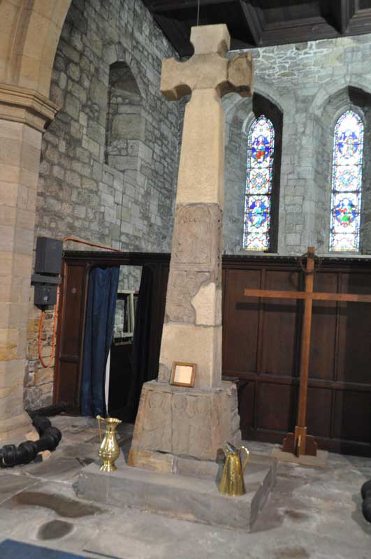
Auckland St Andrew Ancient Cross submitted by Anne T on 20th Oct 2014. The reconstructed ancient churchyard cross within St. Andrew's Parish Church in Auckland. It stands 3.66 metres tall and is covered in carvings, including leaf scrolls with birds and animals, an archer shooting at birds, Christ bound to the cross with rope and all 12 apostles.
(View photo, vote or add a comment)
Log Text: Auckland St Andrew Ancient Cross: This church is open during the day between May and the end of September, so I’d had to arrange a special appointment with the Church Warden to visit at 10am. In the event, the ladies were in arranging flowers in the church, so it would have been possible to gain entry today. The warden's wife told me that they hadn’t had the numbers of volunteers this year to open the church on more days this year.
The cross is almost hidden from view when you go in, lost amongst the grandeur of the rest of the church, and nestled underneath the eastern arch. It struck me that if it had been located a few feet further forward, it would have welcomed visitors into the church.
I could only find The AS Corpus artefacts labelled Auckland St. Andrew 1, 3 and 4. No. 2, which measured 9.5 ins by 7.8 ins by 3.9 ins appeared to be missing, despite being allowed to clamber over the barrier to look behind the tomb stones and with 2 of us looking. As this is the piece with a foot on, this was a shame.
There was no guide book at the church but was given a great verbal history. The Warden was very proud of the almost complete list of rectors and deans since the church was first established in 1085, kept in the south transept. He also told me the reason the door in the south west corner of the church was so tall; apparently the lord of the manor used to ride his horse into church, tether it near where the font is now, then take his place in his private pew. Some years ago, some masonry fell internally near the font. The Warden came in and found the rubble - had a service been taking place a the time there would have been injuries.
I was made to feel very welcome here, and invited to come back, if I telephoned in advance to arrange a date and time.
Axwell Park Barrow
Trip No.18 Entry No.3 Date Added: 24th Apr 2017
Site Type: Round Barrow(s)
Country: England (Tyne and Wear)
Visited: Couldn't find on 23rd Apr 2017. My rating: Ambience 2 Access 5
Axwell Park Barrow submitted by durhamnature on 7th Aug 2012. Axwell Park Barrow
(View photo, vote or add a comment)
Log Text: Axwell Park Tumulus, Gateshead: OK, even with the grid reference, we couldn't find any trace of this - not surprising, since checking the Pastscape records this morning (24th April), they say no trace of the mound exists! There were lots and lots of humps and hollows on the slope to the left of the path as you walk up the hill. The area seems to be part of an estate and has been heavily modified, with an artificial waterfall and stone-lined channels for water visible in the undergrowth.
This area today is on the edge of a modern housing estate, which is still being constructed. The only thing I can say about this is that it is an easy walk up through the park on tarmacked road.
Balbirnie
Trip No.110 Entry No.1 Date Added: 13th Nov 2018
Site Type: Stone Circle
Country: Scotland (Fife)
Visited: Yes on 1st Nov 2018. My rating: Condition 3 Ambience 4 Access 5

Balbirnie submitted by Nick on 5th Nov 2002. From the A92 running north from Glenrothes, turn east onto the un-numbered road for Star and Kennoway. 100m along this road is a sign for the Balbirnie housing development, turn in here and about 150m/200m along, where the road curves right, you will see the circle just below you. Park up in the housing development itself and walk back. The site itself dates from c3000 B.C., and used to be located 125m to the north west of where it stands at present. It was always known locally as the "Druid...
(View photo, vote or add a comment)
Log Text: Balbirnie Stone Circle: It was a good job we had the SatNav and the GPS, which took us almost to the spot. As this was right next to a modern housing estate, we found layby to park in about 100m metres away in Tofthill and walked back to the stone circle, which has a footpath running to its eastern side. Nicely preserved stone circle with cists with an information board and a recreated rock art panel.
We took a few minutes to spot the rock art panel, but realised it had fallen over slightly, so wasn't very visible. I did my best to photograph it in situ.
Balfarg Henge
Trip No.110 Entry No.2 Date Added: 12th Nov 2018
Site Type: Henge
Country: Scotland (Fife)
Visited: Yes on 1st Nov 2018. My rating: Condition 3 Ambience 4 Access 5
Balfarg Henge submitted by cosmic on 4th Dec 2003. Balfarg is a henge which was excavated when a housing estate was built round it in the 1970's. There are only two standing stones but post holes found inside the henge have been marked with a set of wooden posts.
Surprisingly only one part of the henge ditch seems to have been subject to vandalism (by bikes?)
(View photo, vote or add a comment)
Log Text: Balfarg Henge: From Balbirnie stone circle, to reach this recreated henge, we needed to turn right across the busy A92, then almost immediately left down the B969 Western Avenue. The SatNav then took us directly to the henge. Right in the middle of a housing estate, on a circular street appropriately called ‘The Henge’.
Typically for me, just as we stopped the car and I jumped out with my camera, a large delivery van decided to draw up and park in one of the parking spots right next to the outer boundary of henge, so I tried to avoid photographing him!
Balfarg Riding School mortuary enclosure and henge
Trip No.110 Entry No.3 Date Added: 13th Nov 2018
Site Type: Henge
Country: Scotland (Fife)
Visited: Yes on 1st Nov 2018. My rating: Condition 3 Ambience 3 Access 4
Balfarg Riding School mortuary enclosure and henge submitted by SandyG on 3rd Jan 2015. The reconstructed mortuary enclosure. View from north west (19th April 2014).
(View photo, vote or add a comment)
Log Text: Balfarg Riding School Henge Reconstruction: This now recreated henge is just by the A92, at the end of Old Leslie Road, with part of it seeming to have been cut by the construction of the A92. Traffic streams by constantly.
We arrived with the sun high in the sky and deep shadows, which tested my photography skills. I had expected a circular henge, but this was oval. I didn't pick up any atmosphere at this site at all. Sadly, it was just like walking through some old fence posts set up to cast some interesting shadows.
The information board reads: “You are standing in a revered landscape where ceremonies were performed by generations of prehistoric people. Here is an artist’s reconstruction of how the stone circle looked around 4,000 years ago. By this time it had already been in use for 1,000 years, when it became a place of burial. It stood close to the Coul Burn which then enclosed a wider sacred landscape. The picture shows the site of the Balfarg Henge and timber enclosure in the distance.”
Balliemore (Craigendive)
Trip No.48 Entry No.1 Date Added: 4th Oct 2017
Site Type: Standing Stones
Country: Scotland (Cowal)
Visited: Yes on 21st Sep 2017. My rating: Condition 3 Ambience 4 Access 4
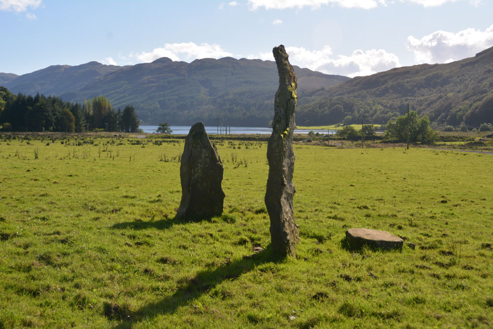
Balliemore (Craigendive) submitted by Anne T on 4th Oct 2017. Standing to the north of these two stones, looking south to the head of Loch Striven. A glorious location.
(View photo, vote or add a comment)
Log Text: Ballimore Standing Stones, West of Dunoon: To escape the rain in Armadale, we decided to take the ferry from Gourock to Dunoon. We stopped off in Dunoon for a cup of tea and a sandwich at The Tudor Coffee Shop above Thornton’s on the main high street, then we set off into the countryside, taking the B836 to Craigendive, past Loch Tarsan.
I spotted these on the map and as they were not very far off the beaten track, decided to stop off and find them. These two stones were in one of the loveliest places, just off the B836 (essentially a single-track road with passing places), to the north of Loch Striven. Surrounded by hills on three sides, on a lush, level grassy plain, with Loch Striven to the south, these standing stones lie immediately south of Balliemore Farm. We parked at NS 05511 84269, next to a pile of road gravel and stones, and walked up the track towards the farm.
There is one tall, narrow stone, and a shorter, triangular one, with a third slab lying at the base of the taller one. Packing stones can be seen in the grass.
The field was very, very wet, and we had to jump over the pools of water at the edge, particularly around the telegraph poles. A pair of wellies would have come in extremely handy!
Ballymeanoch Kerb Cairn
Trip No.18 Entry No.19 Date Added: 3rd Aug 2018
Site Type: Cairn
Country: Scotland (Argyll)
Visited: Yes on 18th Jul 2018. My rating: Condition 2 Ambience 4 Access 4
Ballymeanoch Kerb Cairn submitted by caradoc68 on 11th Dec 2011. NR 83395 96429, Kerb cairn, Ballymean. Kilmartin Glen is a very interesting area in Argyll rich in Archaeology. This Kerb cairn in know exception, being on private land the farmer has kindly fenced it off with pubic access to severely Neolithic/Bronze age features in this field.
(View photo, vote or add a comment)
Log Text: Ballymeanoch Kerb Cairn: With a number of other cars pulling up in the car park with other people wanting to look at the cairn, we hastened down the marked path towards the stone row, wondering why there were large, fresh cowpats in the cordoned off pathway. We were shortly to be confronted by a large bullock who stood and stared at us, completely blocking the path. The wire fence between the field/woodland and the path had been knocked down and the cattle had invaded, some sitting by the gate. This bullock absolutely refused to move, and his other companions started to stir and look our way. Andrew tried to move it away, but it stood firm and looked as if it might charge. Even Andrew backed away at this point.
Fortunately, there was a gate into a field of pasture to our left hand side, so we let ourselves into that field of pasture and followed the fenced off path along on the wrong side of the fence. There was another gate, leading from a track from the road, into the standing stone field. This gate was next to a babbling stream with a stone bridge across. This field also had a large number of other large bullocks, but these continued grazing and took little notice of us until we got to the two standing stones at the far end, when they started to take a definite interest.
Having made sure we weren’t going to be under (immediate) danger of attack by the bullocks, we tiptoed carefully further into the field. Having read about the cairn in "In The Footsteps of Kings" booklet, I circled it and photographed it as best I could. The sun was intense, being low in the sky, and it was so hot I could have laid down on the ground and fallen asleep. However, time was pressing, so I gathered my courage and explored further.
Ballymeanoch Stone Row
Trip No.88 Entry No.20 Date Added: 3rd Aug 2018
Site Type: Stone Row / Alignment
Country: Scotland (Argyll)
Visited: Yes on 18th Jul 2018. My rating: Condition 3 Ambience 5 Access 4

Ballymeanoch Stone Row submitted by ainsloch on 3rd Apr 2015. Stone Roses
(View photo, vote or add a comment)
Log Text: Ballymeanoch Stone Row: Continued from 88.19 visit report (“Who let the bullocks out?”). This was our last stop of the day. We had hoped to fit in DunnAd fort, but we were ‘all monumented out’ by this time of the evening. A truly wonderful spot, with some fantastic standing stones/stone row.
We didn’t get to see the henge due to the very large and very challenging bullocks in the field, but a really fantastic way to end our day.
Bamburgh Barrow 1
Trip No.102 Entry No.6 Date Added: 13th Oct 2018
Site Type: Round Barrow(s)
Country: England (Northumberland)
Visited: Saw from a distance on 9th Oct 2018. My rating: Condition 1 Ambience 3
Bamburgh Barrow 1 submitted by SolarMegalith on 13th Feb 2014. A Bronze Age cist with broken capstone and one of the upright stones visible (photo taken on February 2014).
(View photo, vote or add a comment)
Log Text: Rubbing Stone & Tumulus, Bamburgh: Spotted this apparent 'standing stone' in the field when we were walking back along Doctor's Lane towards St Aidan's Well. There was no obvious way into the field along this route, and we'd already walked for miles, so we contented ourselves with photographing from the stone wall in the next field.
On researching this site when I got home, found out that it was marked on the 1860 OS map as a tumulus with rubbing stone. The tumulus has now been destroyed and the stone is a 19th century insertion into the mound.
Had we realised there was still a visible cist, we might have tried harder to access the field. However, there is such a lot of history in Bamburgh, I'm sure we'll be making a return trip in the not too distant future.
Bamburgh Castle
Trip No.102 Entry No.4 Date Added: 10th Oct 2018
Site Type: Sculptured Stone
Country: England (Northumberland)
Visited: Yes on 9th Oct 2018. My rating: Condition 3 Ambience 4 Access 3
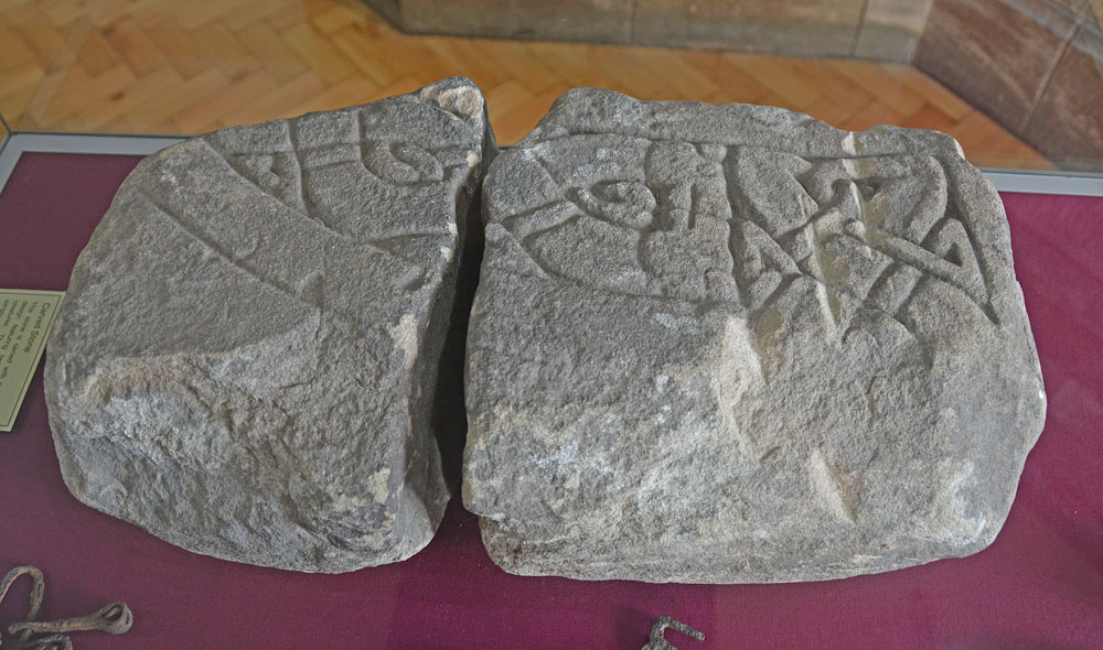
Bamburgh Castle submitted by Anne T on 10th Oct 2018. This piece of carved stone is recorded in the Corpus of Anglo Saxon Stone Sculpture as the 'Bamburgh Castle' stone. Its style dates it to the last quarter of the eighth century to the first quarter of the ninth. Originally described in the 19th century as part of a large cross head, it is know known to be part of the arm of a stone chair or throne. A reproduction can be found outside the keep of the castle, although the Corpus says it is not clear if it is meant to be part of the back or seat.
(View photo, vote or add a comment)
Log Text: Wells and Anglo Saxon Stones at Bamburgh Castle: Note: there is disabled parking next to the State Rooms, but there are many stairs in and around the castle. It’s been a long time since we last came here, and the visit today happened because I’d been sent a 1947 Antiquarian paper about the holy wells of Northumberland. There was also one piece of AS stone in the archaeological museum; listed on the Corpus, which we had still to see.
It was sunny but windy, high up above the sea. It was expensive to get in, but actually was worth the money, as we spent hours here, both wandering around inside and outside.
We found another stone with Celtic Heads in the small Stones Museum, along with a 9th century mortar stone which had been reused to hold a post.
The carved Anglo Saxon stone was in the new Archaeological Museum and Activity area, and there is a recreation of the chair/throne the chair may have looked like outside the keep. This was a favourite for photographs for visitors, so we looked at when it got quieter at the end of the castle opening hours.
Before our visit, I had contacted the castle to try and ascertain the location of three wells inside the castle. There is one well in bottom of keep; the other on the outside wall of the castle at its north western end (no longer visible, but the site can be seen, although covered in sand). The third well we thought we’d found, as we walked up the old Victorian footpath to the castle from the beach, but we were mistaken as we’d had the 1860 OS map orientated wrongly!
Once we’d been round the castle near the ticket office (found when walking back to the car park from the old Victorian footpath from the beach to the castle).
Bampton Grange Cross
Trip No.180 Entry No.2 Date Added: 10th Jul 2022
Site Type: Ancient Cross
Country: England (Cumbria)
Visited: Yes on 9th Jul 2022. My rating: Condition 3 Ambience 4 Access 4

Bampton Grange Cross submitted by Anne T on 10th Jul 2022. The cross / boundary marker has some amazing views across the fells.
(View photo, vote or add a comment)
Log Text: Bampton Grange Cross: A glorious day. We'd previously seen this cross in August 2020, when lockdown restrictions had been briefly lifted for a short time, but I didn't post any photographs. That day had been grey and the cemetery busy with people strimming grass around family graves. Today was glorious, and we had the cemetery to ourselves (living people, that is).
This cross has had a hard life, but has spectacular views over the fells.
We finished this visit with a trip to the Bampton Village Store which served teas, toasties and cream teas, and were made very welcome. NY 51505 18200, with a parking area to the side of the store.
Barcombe Hill Settlement
Trip No.70 Entry No.1 Date Added: 6th May 2018
Site Type: Ancient Village or Settlement
Country: England (Northumberland)
Visited: Yes on 5th May 2018. My rating: Condition 2 Ambience 4 Access 4
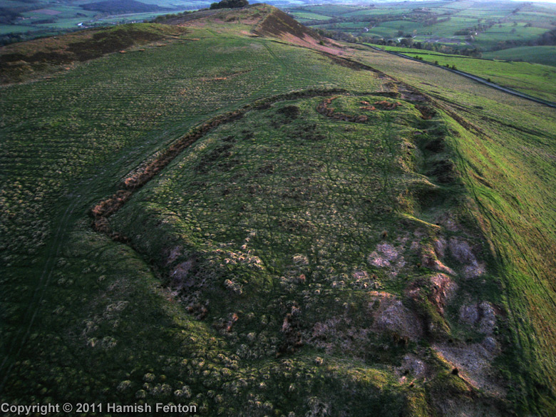
Barcombe Hill Settlement submitted by h_fenton on 22nd Jul 2011. Barcombe Hill Settlement viewed from the northeast with low evening light. The feature at the far end of the settlement is the Roman Signal Station
Kite Aerial Photograph
24 April 2011
(View photo, vote or add a comment)
Log Text: Barcombe Hill Iron Age Defended Settlement and Roman Signal Station: On a very hot bank holiday Saturday, we decided to try and go somewhere a little cooler, so set off towards Bardon Mill (OK, I was born to live in Scandanavia, not hotter climes). We'd previously tried to visit this site but used a route from nearer the Long Stone, on a day when dog races were taking place and there were lots and lots of people, plus when we approached the settlement, there was a huge bull and his ladies (we beat a hasty retreat).
Today we parked by the junction of Stanegate with the minor road running to Bardon Mill through Westend Village. A gate led us into the field and there was a mowed trackway leading up to the settlement (a note on the gate said the Open Access land was closed for the week before and a few days after our visit). We wandered over the settlement - the bank and ditch on the southern side is well preserved, but the northern edge has been quarried and there are some deep holes.
Making our way over to the Roman Signal station, I saw Andrew fall over in slow motion - his foot had gone down a hidden rabbit hole up to his knee. Once we'd spotted these holes, which were everywhere, we kept to the sheep tracks to avoid falling again.
After walking round the settlement, we made our way up to the Trig Point to get a view down.
Barmishaw Stone
Date Added: 20th Apr 2015
Site Type: Rock Art
Country: England (Yorkshire (West))
Visited: Couldn't find on 17th Apr 2015
Barmishaw Stone submitted by DavidRaven on 3rd Nov 2003. The Barmishaw Stone. Very faint carvings including the odd 'ladder' motif. I
could hardly make out the shapes. The stone is just above the wood near the
'Keighley Road' track that traverses the moor, west of White Wells, by a
footpath.
(View photo, vote or add a comment)
Log Text: Barmishaw Stone, Ilkley: we planned to find this piece of rock art after visiting the Comet Stone as it's not far away. From the small car park on the Keighley Road near the Comet Stone grid reference, there is no direct footpath but a track through the moorland grass could be made out. My husband was bold enough to try, but his route was blocked by a rock face. An approach from a different direction will be needed on our next visit.
We abandoned finding this stone to get to the Wulfhere Cross at Addingham before the church closed for the evening.
