Contributory members are able to log private notes and comments about each site
Sites Anne T has logged. View this log as a table or view the most recent logs from everyone
Houghton Camp, Heddon on the Hill
Date Added: 1st Jul 2014
Site Type: Ancient Village or Settlement
Country: England (Northumberland)
Visited: Yes on 1st Jul 2014. My rating: Condition 1 Ambience 2 Access 3
Houghton Camp, Heddon on the Hill submitted by durhamnature on 16th Aug 2012. Houghton Camp, north ditch and earthworks.
(View photo, vote or add a comment)
Log Text: Return visit on 1st July 2014: I obtained permission from Close House Golf Club to walk across the golf course to look at the settlement from the side furthest from the road. They told me that they are unable to do anything with this parcel of land 'because of the antiquities, but there isn't much to see' and were sure that the farmer they lease the land from would be happy for me to visit, having asked permission.
Parking was a problem again; I tried the field gates next to the road, but they were tied very firmly shut and the next gate to the field with the camp in hadn't been opened in a very long time, so to avoid climbing over, I parked at the Golfing Range and walked back towards the road over the golf course to the settlement - all slightly uphill, but very pleasant in the warm sunshine, and what views back over the Tyne Valley.
I confess to having been disappointed, as the banks and ditches weren't as clear from this side of the site as from the road. Having walked up to the eastern end of the camp, and to the highest point in this landscape adjacent to the field boundary, the yellow (parched) grasses gave a vague indication of where the banks were.
The aerial photographs of the camp show a very clear blunt-ended oval shape, and having driven along this road for many years to and from work, I am determined to have another look in the winter months to see if any structures become clearer.
A local lady told me the nearby farms are historic and are well worth a visit, having medieval features.
First visit on 18th June 2014: I was visiting Heddon-on-the-Wall today, to see the section of Hadrian's Wall at the east edge of the village, plus the ancient church of St Andrew's in the village centre, and spotted this settlement on the Portal.
I had to drive past several times and eventually managed to park in a field entrance. I did try driving down the entrance to Close House Golf Course/Hotel, to see if I could walk across the grounds to see the site from the south, but there was nowhere to stop at all.
The photograph on the Portal was very helpful in identifying the part of the field the settlement was in, as I struggled to separate the ditches/boundaries of the settlement from the works that had been done for the pylon on the east side, and the golf course on the west. Away from the field entrance, the hedges were too high (for me) to see over.
I have applied to the landowner for permission to walk across the fields to get closer to the settlement, to take photographs from a better angle, so will report back if I manage to get agreement, and re-visit this site (which is only a few miles from my house).
Bygate Hill
Date Added: 23rd Jun 2014
Site Type: Standing Stone (Menhir)
Country: England (Northumberland)
Visited: Yes on 22nd Jun 2014. My rating: Condition 3 Ambience 4 Access 4

Bygate Hill submitted by PaulH on 3rd Mar 2003. Northumberland
NZ069770
(View photo, vote or add a comment)
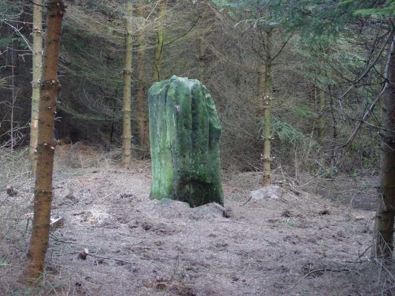
Log Text: Having previously visited the site the weekend previously, we were put off from going in by alarms coming from within the plantation and a notice 'not to enter without the necessary authority' on the gate, so I sought the landowner's permission to enter. Bygate Hill Plantation houses a telecommunications mast (which apparently requires a permit to go near) and the landowner told me there are also regular paintballing activities carried out within the plantation.
There is a grassy track from the gate to the mast, with a small track running off to the right (just before the mast) through the trees which leads to the stone which stands in a small clearing.
The standing stone itself is impressive, and very atmospheric amidst the trees with the sunshine breaking through.
The land surface has clearly built up with all the leaf debris built up around the base of the stone, which also appears to have been propped up on one side by two smaller stones, to stop it leaning further.
There also appears to be a smaller buried (heel?) stone within a few yards of the main stone.
Had it not been for the trees, the site would command superb views of the surrounding land. We later walked up to West Bitchfield Peel Tower (grid reference: NZ 09081 77126) and looked back towards the plantation. The views were magnificent.
The landowner told me that Buddhist Monks from nearby Harnham Monastery regularly visit the stone and hang bells, and indeed there are charms and wind chimes on the trees surrounding the stone, and offerings placed on top of the stone.
Paines Bridge, Wallington B
Date Added: 4th Aug 2014
Site Type: Rock Art
Country: England (Northumberland)
Visited: Yes on 29th Jul 2014. My rating: Condition 3 Ambience 3 Access 4
Paines Bridge, Wallington B submitted by SolarMegalith on 22nd Jun 2013. Groove on Paines Bridge, Wallington B stone - view from the west (photo taken on June 2013).
(View photo, vote or add a comment)
Log Text: Visit report logged under 'Wallington A', as there are three stones within 2 metres of each other. Worth looking for if you are passing by Paine's Bridge/Wallington House.
Paines Bridge, Wallington C
Date Added: 4th Aug 2014
Site Type: Rock Art
Country: England (Northumberland)
Visited: Yes on 29th Jul 2014. My rating: Condition 3 Ambience 3 Access 4
Paines Bridge, Wallington C submitted by SolarMegalith on 22nd Jun 2013. Possible cup-mark with a groove on Paines Bridge, Wallington C stone (photo taken on June 2013).
(View photo, vote or add a comment)
Log Text: Full visit report under 'Wallington A', as there are three boulders with rock art within 2 metres of each other in the same location. Worth a visit if you pass over Paine's Bridge or are visiting Wallington House.
Goatstones Four-Poster
Date Added: 1st Jul 2014
Site Type: Stone Circle
Country: England (Northumberland)
Visited: Yes on 30th Jun 2014. My rating: Condition 4 Ambience 4 Access 4

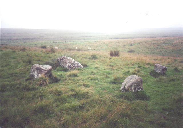
Goatstones Four-Poster submitted by cosmic on 13th Feb 2005. Another of Goatstones courtesy of Ian Simpson
(View photo, vote or add a comment)
Log Text: There are a couple of parking spaces next to 'Manor House' on Ward Lane, just below Ravensheugh Crags, and followed the footpath up to the crags, turning right up to the stone circle.
It is an easy walk, with spectacular views - the visibility was around 30 miles - we could see the Cheviot Hills in the distance.
The stones of this unusual four poster stone circle are low to the ground (with other outlying stones buried in the grass around?) but very atmospheric. It feels very remote, with very little noise apart from birdsong, although there is a steady (but small) stream of traffic along Ward Lane.
There are very definite cup marks on the eastern most stone, and other possible cups on the southern most stone (now partly toppled and hidden by marsh grass).
We met the farmer from Great Lonbrough, at the very end of the footpath, and he told us more about the hut circles and cairns in the fields below. We checked the Portal when we got home and were inspired by the photographs of the rock art at Goatstones, so we intend to go back and look again in the next few weeks and look at these, plus also walk along to Standingstone Rigg.
Will most definitely visit again.
North Plantation A
Date Added: 6th Sep 2014
Site Type: Rock Art
Country: England (Northumberland)
Visited: Would like to visit
North Plantation A submitted by SolarMegalith on 5th Oct 2013. Simple cup-marks near the top of the panel (photo taken on October 2013).
(View photo, vote or add a comment)
Powburn Rock Art
Date Added: 21st Sep 2014
Site Type: Rock Art
Country: England (Northumberland)
Visited: Yes on 22nd Sep 2013. My rating: Condition 2 Ambience 3 Access 5
Powburn 1 submitted by SolarMegalith on 16th Mar 2013. The main motif - a cup with two rings (photo taken on March 2013).
(View photo, vote or add a comment)
Log Text: Stopped at the Visitor Centre during our Breamish Valley Hill Fort Trail walk, to visit St. Michael's Church at Ingram.
Beautiful setting next to the river. Came across this stone quite by chance outside the Visitor Centre (now closed and The Muddy Boots Cafe).
Goatstones B
Date Added: 22nd Sep 2014
Site Type: Rock Art
Country: England (Northumberland)
Visited: Yes on 21st Sep 2014. My rating: Condition 3 Ambience 3 Access 3
Goatstones B submitted by SolarMegalith on 4th Jul 2013. Close-up of the cup-marks carved on the ridge of Goatstones B panel (photo taken on June 2013).
(View photo, vote or add a comment)
Log Text: Goatstones B, Simonburn, Northumberland: see visit report for Goatstones A (14 rock art stones in near to each other).
Goatstones C
Date Added: 22nd Sep 2014
Site Type: Rock Art
Country: England (Northumberland)
Visited: Yes on 21st Sep 2014. My rating: Condition 3 Ambience 3 Access 3
Goatstones C submitted by SolarMegalith on 4th Jul 2013. The motif described by Stan Beckensall is not distinguishable anymore, it coulnd not be traced by NADRAP team either (photo taken on June 2013).
(View photo, vote or add a comment)
Log Text: Goatstones C: see visit report for Goatstones A (group of 14 stones in same area).
Goatstones D
Date Added: 22nd Sep 2014
Site Type: Rock Art
Country: England (Northumberland)
Visited: Yes on 21st Sep 2014. My rating: Condition 3 Ambience 3 Access 3
Goatstones D submitted by SolarMegalith on 4th Jul 2013. The largest and best defined cup-mark on Goatstones D panel (photo taken on June 2013).
(View photo, vote or add a comment)
Log Text: Goatstones D, Simonburn, Northumberland: see visit report for Goatstones A (14 stones near to each other).
Goatstones E
Date Added: 23rd Sep 2014
Site Type: Rock Art
Country: England (Northumberland)
Visited: Yes on 21st Sep 2014. My rating: Condition 3 Ambience 3 Access 3
Goatstones E submitted by SolarMegalith on 5th Jul 2013. Close-up of the cup-mark (photo taken on June 2013).
(View photo, vote or add a comment)
Log Text: Goatstones E, Simonburn, Northumberland: See visit report for Goatstones A (14 rock art stones within a couple of hundred yards).
Goatstones F.
Date Added: 23rd Sep 2014
Site Type: Rock Art
Country: England (Northumberland)
Visited: Yes on 21st Sep 2014. My rating: Condition 3 Ambience 3 Access 3
Goatstones F. submitted by SolarMegalith on 5th Jul 2013. Cup-marks near the top of Goatstones F boulder (photo taken on June 2013).
(View photo, vote or add a comment)
Log Text: Goatstones F, Simonburn, Northumberland: See visit report for Goatstones A (14 rock art stones with a couple of hundred yards of each other).
Goatstones G
Date Added: 23rd Sep 2014
Site Type: Rock Art
Country: England (Northumberland)
Visited: Yes on 21st Sep 2014. My rating: Condition 3 Ambience 3 Access 3
Goatstones G submitted by SolarMegalith on 7th Jul 2013. Possible cup-marks which might be erosion features (photo taken on June 2013).
(View photo, vote or add a comment)
Log Text: Goatstones G, Simonburn, Northumberland: See visit report for Goatstones A (14 rock art boulders within a couple of hundred metres)
St Mungo's Church
Date Added: 9th Jul 2014
Site Type: Ancient Cross
Country: England (Northumberland)
Visited: Yes on 9th Jul 2014. My rating: Condition 3 Ambience 3 Access 5

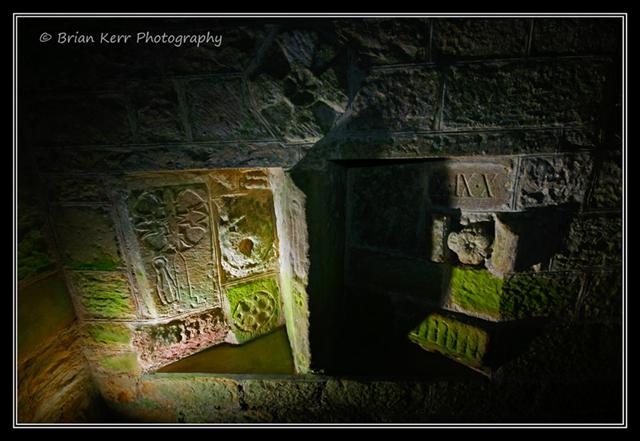
St Mungo's Church submitted by wolfnighthunter on 7th Dec 2008. Christian Cross built into the walls of St Mungo's Church, Simonburn, Northumberland
(View photo, vote or add a comment)
Log Text: I'd read about the hog's-back tombstone located in this church, and as Simonburn is only 20 miles away from our house, took advantage of the sunshine to go and explore. By absolute chance, I happened to arrive at the same time as a small coach party who had booked an organised tour with the vicar, so took myself off to the Old Post Office nearby (the only tea shop in this small hamlet) to have lunch.
Whilst the site of the church is very old, there are only a few small parts of the stone 13th century structure visible; the rest is 18th and 19th century, although if you look hard enough (and use the visitor notes available in the church) it's possible to spot some old gems of tombstones and other features built into the current fabric of the building.
The remains of the hogs-back tomb is built into the east wall of the porch, placed vertically in the centre of a display of other interesting artefacts, including (quoting from the visitor notes here!): parts of a medieval table-tomb with shears on; parts of two 13th and 14th century tomb covers; in the left and right hand corners examples of Anglian or Roman champfered impost moulding; a piece of double roll moulding with rosettes; part of the original sundial; part of a coat of arms from a medieval tomb and what is purported to be the central boss of the stone cross on the opposite west wall (Note that when you turn round to look at this said stone cross shaft, it has been clearly cut in half at some point).
Above this group there is also the remains of a stone cross.
Even though only a small portion of the hog's back tombstone remains, it is impressive, which miniature roof tiles clearly visible on both sides. The visitor notes say that the tombstone was reused in medieval times, having shears and three rosettes carved on the roof-ridge.
On a previous visit to Simonside recently, we went in search of the old castle (not much remains, and it's apparently a folly anyway), plus an old well near the river (which we couldn't find).
There is parking at the tea shop, or off the road to the left hand side of the church as you enter the village.
Goatstones H
Date Added: 23rd Sep 2014
Site Type: Rock Art
Country: England (Northumberland)
Visited: Yes on 21st Sep 2014. My rating: Condition 3 Ambience 3 Access 3
Goatstones H submitted by SolarMegalith on 7th Jul 2013. Depressions on Goatstones H, probably erosion features (photo taken on June 2013).
(View photo, vote or add a comment)
Log Text: Goatstones H, Simonburn, Northumberland: see visit report for Goatstones A (14 rock art boulders within a couple hundred metre area)
Goatstones J
Date Added: 23rd Sep 2014
Site Type: Rock Art
Country: England (Northumberland)
Visited: Yes on 21st Sep 2014. My rating: Condition 4 Ambience 4 Access 3
Goatstones J submitted by SolarMegalith on 7th Jul 2013. This decorated portable bears a single cup-mark (photo taken on June 2013).
(View photo, vote or add a comment)
Log Text: Goatstones J, Simonburn, Northumberland: This was a real treat - a marker stone on top of an apparently undisturbed cairn. For rest of visit report, see Goatstones A (14 rock art boulders within a couple of hundred metres).
Goatstones N
Date Added: 23rd Sep 2014
Site Type: Rock Art
Country: England (Northumberland)
Visited: Yes on 21st Sep 2014. My rating: Condition 3 Ambience 3 Access 3
Goatstones N submitted by SolarMegalith on 10th Jul 2013. Close-up of the cup-mark on Goatstones N (photo taken on June 2013).
(View photo, vote or add a comment)
Log Text: Goatstones N, Simonburn, Northumberland: See visit report for Goatstones A (14 rock art boulders all within a couple of hundred metres)
Goatstones O
Date Added: 23rd Sep 2014
Site Type: Rock Art
Country: England (Northumberland)
Visited: Yes on 21st Sep 2014. My rating: Condition 3 Ambience 3 Access 3
Goatstones O submitted by SolarMegalith on 10th Jul 2013. General view of Goatstones O panel (photo taken on June 2013).
(View photo, vote or add a comment)
Log Text: Goatstones O, Simonburn, Northumberland: See visit report for Goatstones A (14 rock art stones/boulders within a couple of hundred metres).
Davy's Lee Enclosure
Date Added: 21st Jul 2014
Site Type: Misc. Earthwork
Country: England (Northumberland)
Visited: Yes on 20th Jul 2014. My rating: Condition 2 Ambience 4 Access 2
Davy's Lee Enclosure submitted by SolarMegalith on 28th Mar 2014. A bank in the northern part of Davy's Lee enclosure - view from the east (photo taken on March 2014).
(View photo, vote or add a comment)
Log Text: Continuing south on the footpaths from Standingstone Rigg at Great Lonbrough would have brought us to Davy's Lee Settlement and Davy's Lee Stone Circle and tumuli, but on this walk we elected to park at the Old Repeater Station, just off the B6318 (old military road), and follow the footpath to Sewingshields Crags, on the opposite side of the road.
We've done this walk before, but only to see the Roman Loughs (fishing ponds) in 2011, and couldn't do this bit of the walk due to the boggy ground. Note: I wouldn't like to follow this footpath after a period of wet weather - too wet, wellies would be needed!
We followed the footpath through Hadrian's Wall Vallum, up the hill past Sewingshields Farm, then turned round the back to the northern side of Sewingsheilds Crags. At the bottom of the hill, just past the cattle grid, there is a track that leads off to the left hand side which leads to both Davy's Lee Settlement and Davy's Lee Stone Circle.
At the top of the first ridge we came to, there were what appeared to be a row of standing stones, and possibly another small stone circle, but my inexperienced eyes thought I might be confusing these with quarried rocks left lying on the ground. However, we came across some blue posts hammered into the ground and some blue spray-painted crosses; the farmer we met shortly afterwards confirmed that archaeologists had been to do an initial survey of this area.
The footpath disappears for a while, but can be picked up at the western end of this first ridge. After walking up and down another ridge (with another rocky outcrop with a possible empty cairn at the top), it was necessary to cross another boggy piece of land, with a small, bubbling stream at the bottom, then it was an easy walk up to the settlement.
The entrance and the outer banks of the settlement are easily identifiable, and is in a fantastic landscape.
Davy's Lee Stone Circle is about 50 yards to the east of the entrance to the settlement, with other tumuli further to the east.
West Shank Enclosure
Date Added: 1st Aug 2015
Site Type: Misc. Earthwork
Country: England (Northumberland)
Visited: Yes on 15th Jul 2015. My rating: Condition 2 Ambience 3 Access 3

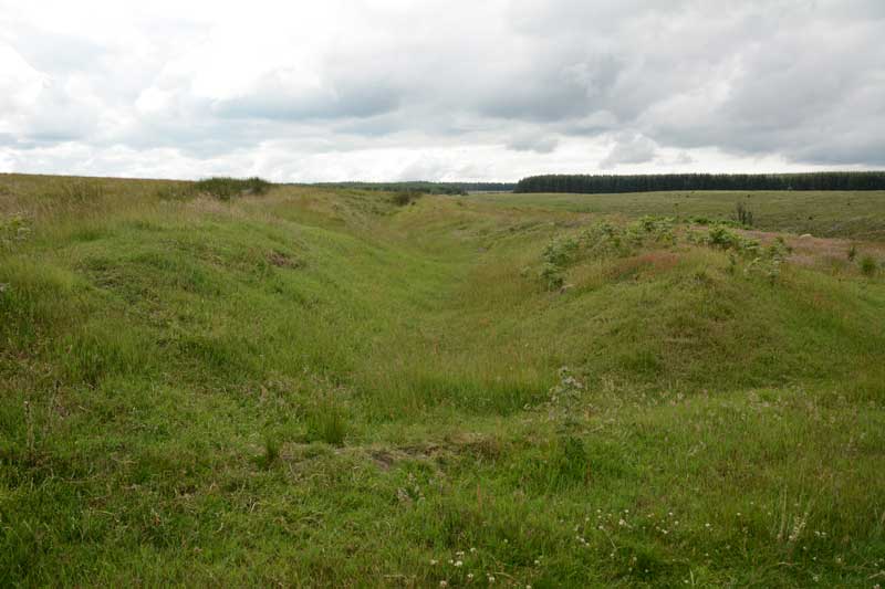
West Shank Enclosure submitted by Anne T on 18th Jul 2015. Standing in the boundary ditch where the footpath cuts the enclosure looking east back towards Hollinghill Enclosure. The banks rise gently up on either side. The vegetation here is short grass, cropped by sheep, so are more obvious than the banks and ditches of the neighbouring Hollinghill Enclosure.
(View photo, vote or add a comment)
Log Text: West Shank Enclosure, near Fontburn Reservoir, Northumberland: See visit report for Hollinghill Enclosure.
