Contributory members are able to log private notes and comments about each site
Sites Anne T has logged. View this log as a table or view the most recent logs from everyone
Glenquicken Circle
Trip No.139 Entry No.1 Date Added: 22nd Jun 2019
Site Type: Stone Circle
Country: Scotland (Dumfries and Galloway)
Visited: Yes on 17th Jun 2019. My rating: Condition 3 Ambience 4 Access 4
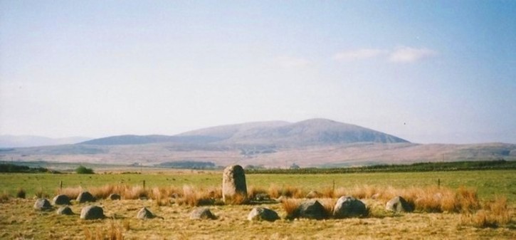
Glenquicken Circle submitted by Bladup on 18th Jun 2013. Glenquicken stone Circle with its centre stone and wonderful setting.
(View photo, vote or add a comment)
Log Text: Glenquicken Stone Circle:
Our first stop of the day, and in a delightfully rural location. There was a small layby just to the east of a bridge over Englishman’s Burn at NX 50847 58492 which was large enough for one car. Walking to the gate into the field at NX 50904 58456, the gate had been tied up with the Gordian Knott, but was eventually undone. There was an easy enough walk of a couple of hundred meters across a lush field of knee deep pasture and wild flowers.
The stone circle was indeed over a fence topped with barbed wire, but a gate to its east at NX 51057 58211 (opposite a modern cairn) let us in to the field, and we followed the small trails through the grass where other people had walked.
This was the first stone circle I’ve seen with a large central stone – can’t recall seeing any like this in Northumberland.
Merrivale settlement
Trip No.133 Entry No.1 Date Added: 22nd Jun 2019
Site Type: Ancient Village or Settlement
Country: England (Devon)
Visited: Yes on 14th May 2019. My rating: Condition 3 Ambience 4 Access 4
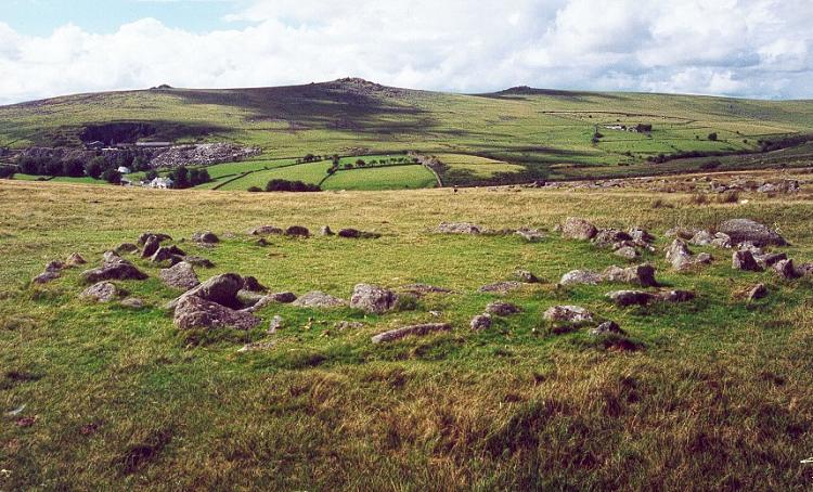
Merrivale settlement submitted by Brian Byng on 7th Feb 2002.
(View photo, vote or add a comment)
Log Text: Merrivale Prehistoric Settlement: This was our first stop of the day as part of a three day guided tour by Sandy G, who certainly knew his way around this site, and all the others in this Bronze Age complex.
We parked in the small car park at SX 55311 75018 and, having introduced ourselves to the rest of Sandy's small Expeditionary Force, we walked the short distance onto the moor to start at this site. With the nearer stone rows within site just at the top of the hill, expectations for an exciting rest of the day rose rapidly.
The only downside was the absolutely howling wind that blew throughout the day, sometimes makingit difficult to stand upright. However, it was a cheap way of exfoliating!
I found out when copying photos from the memory card of my camera to my computer that the external GPS device on my camera had stopped working, so I was unable to identify the precise locations of the hut circles I photographed.
Alnmouth Wall Rock 34
Trip No.138 Entry No.2 Date Added: 13th Jun 2019
Site Type: Rock Art
Country: England (Northumberland)
Visited: Yes on 3rd Jun 2019. My rating: Condition 3 Ambience 3 Access 4
Alnmouth Wall Rock 34 submitted by SolarMegalith on 21st Jan 2013. Possible eroded cup-marks on the surface of Alnmouth Wall Rock 34 (photo taken on January 2013).
(View photo, vote or add a comment)
Log Text: Alnmouth Wall Rock 34: see main visit report for Alnmouth Wall Rock 32.
Alnmouth Wall Rock 36
Trip No.138 Entry No.3 Date Added: 13th Jun 2019
Site Type: Rock Art
Country: England (Northumberland)
Visited: Yes on 3rd Jun 2019. My rating: Condition 3 Ambience 3 Access 4
submitted by on .
(View photo, vote or add a comment)
Log Text: Alnmouth Wall Rock Panel 36: For main visit report see AWR Panel 32. Trying to match these panels with the photos on the ERA records was interesting, but using the grid references taken with our GPS and the photos, I've managed this as best I can.
Alnmouth Wall Rock 37
Trip No.138 Entry No.4 Date Added: 13th Jun 2019
Site Type: Rock Art
Country: England (Northumberland)
Visited: Yes on 3rd Jun 2019. My rating: Condition 3 Ambience 3 Access 4
Alnmouth Wall Rock 37 submitted by SolarMegalith on 22nd Jan 2013. Close-up on the cup-marks (photo taken on January 2013).
(View photo, vote or add a comment)
Log Text: Alnmouth Wall Rock Panel 37: See visit report for Alnmouth Wall Rock Panel 32
Alnmouth Wall Rock 32
Trip No.138 Entry No.1 Date Added: 13th Jun 2019
Site Type: Rock Art
Country: England (Northumberland)
Visited: Yes on 3rd Jun 2019. My rating: Condition 3 Ambience 3 Access 4
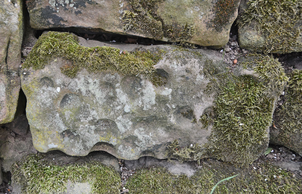
Alnmouth Wall Rock 32 submitted by Anne T on 12th Jun 2019. Close up of Alnmouth Wall Rock Panel 32.
(View photo, vote or add a comment)
Log Text: Alnmouth Wall Rock Panels, Alnmouth: A short walk up a lane towards the trig point, with some very friendly horses in the field and some lovely views over the sea and beach. The wall runs for quite a long way, with its eastern side up a slope so it was a little precarious (for those who don't like slopes!) to photograph those panels.
If you visit, there were many, many rabbit holes, so be careful when walking, especially around the trees and the base of the wall.
I have recorded these panels in the order we saw them on the day. Some of the wall was hidden by wooden fencing (a small fenced off area for farm bits and pieces) and brambles/barbed wire, Many panels at the base and top of the wall are covered by turf, so we only managed to see 11 out of 39.
I have three panels I'm trying to match up my photos with those recorded on ERA (138.7, 8 and 11). Despite having reasonably accurate grid references, it's been a bit of a challenge to match up the and will add these when I can.
Alnmouth Wall Rock 15
Trip No.138 Entry No.5 Date Added: 13th Jun 2019
Site Type: Rock Art
Country: England (Northumberland)
Visited: Yes on 3rd Jun 2019. My rating: Condition 3 Ambience 3 Access 4
Alnmouth Wall Rock 15 submitted by SolarMegalith on 19th Jan 2013. Close-up on the cup-marks (photo taken on January 2013).
(View photo, vote or add a comment)
Log Text: Alnmouth Wall Rock 15: on top of panel 16. For main visit report see Alnmouth Wall Rock 32.
Alnmouth Wall Rock 26
Trip No.138 Entry No.10 Date Added: 13th Jun 2019
Site Type: Rock Art
Country: England (Northumberland)
Visited: Yes on 3rd Jun 2019. My rating: Condition 3 Ambience 3 Access 4
Alnmouth Wall Rock 26 submitted by SolarMegalith on 20th Jan 2013. Close-up on the cup-marks on Alnmouth Wall Rock 26 (photo taken on January 2013).
(View photo, vote or add a comment)
Log Text: Alnmouth Wall Rock 26: for main visit report see Alnmouth Wall Rock 32.
Alnmouth Wall Rock 24
Trip No.138 Entry No.9 Date Added: 13th Jun 2019
Site Type: Rock Art
Country: England (Northumberland)
Visited: Yes on 3rd Jun 2019. My rating: Condition 3 Ambience 3 Access 4
Alnmouth Wall Rock 24 submitted by SolarMegalith on 20th Jan 2013. Close-up on the cup-marks (photo taken on January 2013).
(View photo, vote or add a comment)
Log Text: Alnmouth Wall Rock 24: for main visit report see Alnmouth Wall Rock 32.
Alnmouth Wall Rock 16
Trip No.138 Entry No.6 Date Added: 13th Jun 2019
Site Type: Rock Art
Country: England (Northumberland)
Visited: Yes on 3rd Jun 2019. My rating: Condition 3 Ambience 3 Access 4
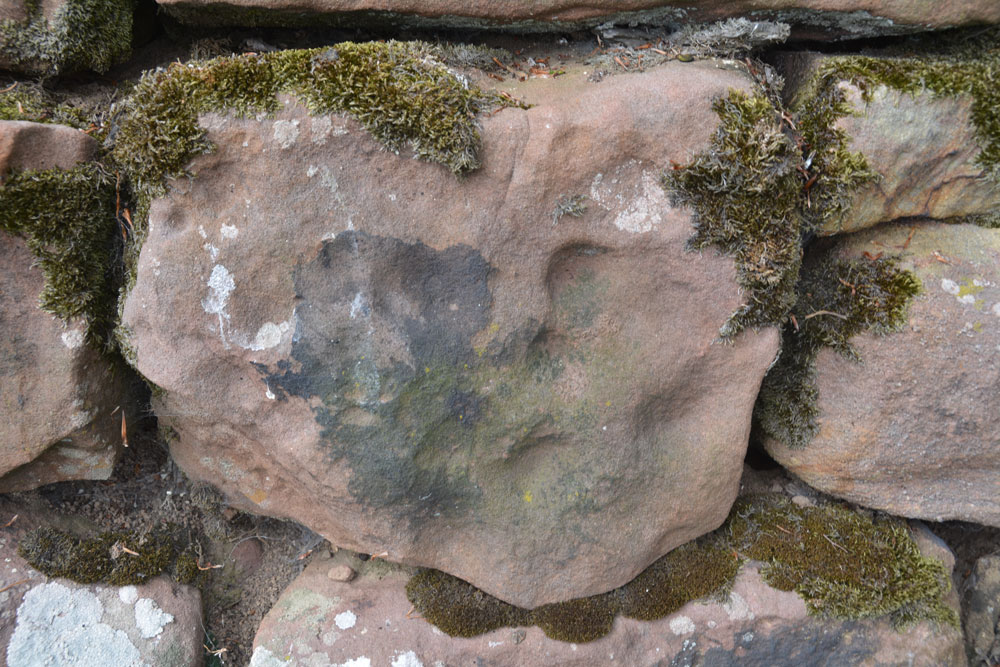
Alnmouth Wall Rock 16 submitted by Anne T on 13th Jun 2019. Alnmouth Wall Panel 16, which Beckensall has a minimum of 16 cups.
(View photo, vote or add a comment)
Log Text: Alnmouth Wall Rock 16: for main visit report see Alnmouth Wall Rock 32
St Laurence's Church (Bradford on Avon)
Trip No.136 Entry No.4 Date Added: 12th Jun 2019
Site Type: Early Christian Sculptured Stone
Country: England (Wiltshire)
Visited: Yes on 17th May 2019. My rating: Condition 3 Ambience 5 Access 4
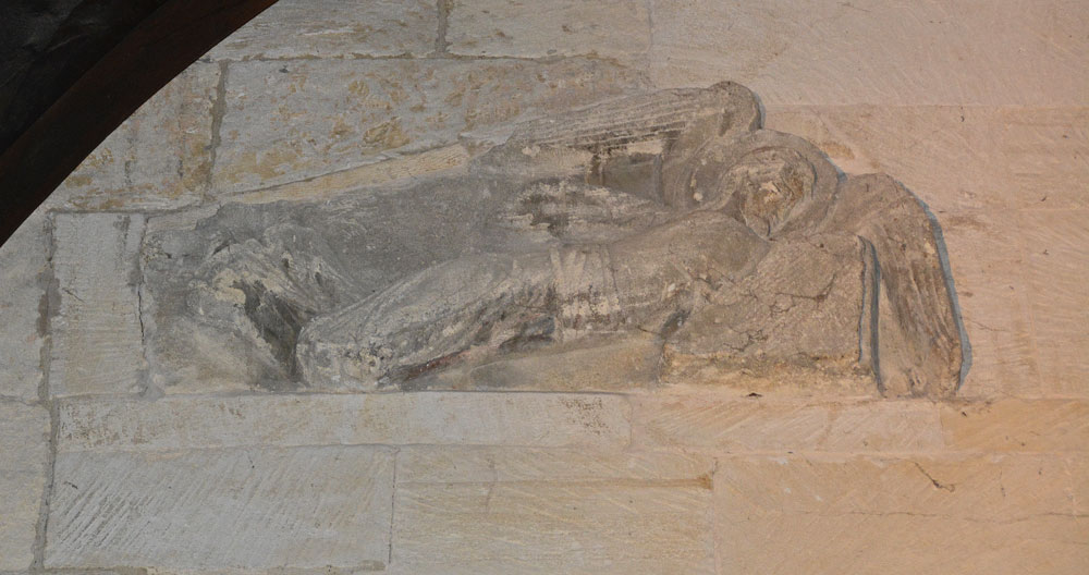
St Laurence's Church (Bradford on Avon) submitted by Anne T on 11th Jun 2019. The right hand facing angel, recorded as AS Corpus Bradford on Avon 5b. They were discovered embedded in a wall above the western side of the chancel arch around 1850, later used in a flue in 1856-1857, then placed over the porch leading to the modern house attached to the south side of the building. Both angels are carved from single blocks of stone, which taper from head to feet, with the angels facing each other. Dated to AD1000.
(View photo, vote or add a comment)
Log Text: St Laurence's Church, Bradford on Avon: From Wells, we had to decide which church was going to be the very last visit of our Dartmoor Expedition, as we were rapidly running out of time – Deerhurst or Bradford-On-Avon. In the end, the decision was down to knowing that St. Laurence’s Church would be open, although only until about 5pm or 5.30pm, so the race was on to battle the traffic to get here in time. Eventually we made it with about 45 minutes to spare, managing to park just round the corner from both St. Laurence’s and Holy Trinity.
What a treasure! I’d read that it was as complete as Escombe Saxon Church, but it felt so different – more doorways and very, very dark. The only spotlights were on the angels over the chancel archway, a small light in the sanctuary, then the rest through the narrow doorways and tiny windows.
The church was a real tourist magnet and I had to wait several times to get a shot without people in the photo. I’m sure I annoyed everyone with my flash, but that was the only way I could photograph the stone fragments.
I’m really pleased I’d printed of the Corpus of Anglo Saxon Stone Sculpture pages before we went, as I understood what I saw at the time. I put my papers down to take a photograph of the altar, coming out of the sanctuary to find someone had picked them up and was reading them. I had to ask nicely for them back and explain these were mine, but there was a leaflet in a box on the south wall of the nave.
I was really sad we couldn’t get this little church to ourselves for ten minutes or so. We ended up having 15 minutes to look into Holy Trinity Church opposite, only to almost get locked in, although we spent 10 minutes or so talking to the very knowledgeable church warden. Then we walked around the town after to avoid the queues of traffic that had built up.
Wells Cathedral
Trip No.136 Entry No.2 Date Added: 12th Jun 2019
Site Type: Early Christian Sculptured Stone
Country: England (Somerset)
Visited: Yes on 17th May 2019. My rating: Condition 4 Ambience 4 Access 4
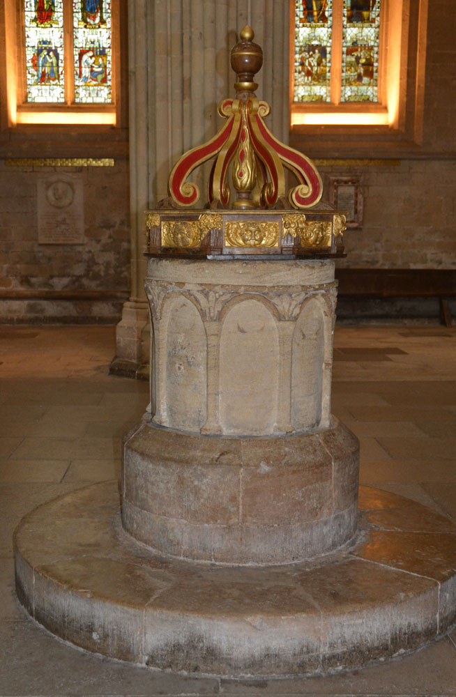
Wells Cathedral submitted by Anne T on 11th Jun 2019. The font in the south transept of Wells Cathedral, recorded as AS Corpus Wells 04, said to be from the original stone cathedral, dated to the 10th to 11th century and recorded as being in situ at this location since the 12th century. The font bowl is cylindrical and tubshaped, and is cut from a single block of Chalfield Oolit limestone. Over the centuries it has been partly recut and remodelled.
(View photo, vote or add a comment)
Log Text: AS Corpus Wells 4, Wells Cathedral: We'd been seriously held up by traffic on the major and minor roads from Exeter to Wells, then by seriously slow roadworks, so were really rushed for time. I'd previously contacted the cathedral to find out if it was possible to see AS Corpus Wells 3, which the Corpus said was in the cathedral store, but the cathedral said they were unable (unwilling) to find it. Thinking the other fragments would be on display, we still went to the Cathedral. Throwing the car into a car park just inside the city centre, I managed to photograph the Market Cross/Bishop Beckington's Conduit before going to the Cathedral.
I showed one of the guides the AS Corpus notes and asked if he knew where they might be on display and were told ‘try the undercroft’. Nothing of note in there – it was very bare with very little displayed.
After wandering up and down the nave and chancel, I stopped another guide, showed her my notes, explained I’d previously emailed. She told me one of the stones was in the library, but a special tour had just started and it would be at least an hour before we could get in, and to look at the fragments built into the walls of the cloisters. She then said she’d find one of the vergers and ask him if he knew where the others were.
Eventually, this very kind lady came to find us and took us to the verger’s office, where he looked at my papers. “Oh, yes”, he said, “I remember the email. Everything is now in storage in the triforium, either in boxes or cages, and can’t be accessed.” “That’s disappointing”, I replied, “why did no one tell me that in the email reply?” We were dismissed without a further word, with the verger turning back to another visitor to his office.
We went to find a late lunch in the cathedral cafeteria, only to find it almost empty and only serving coffee and cakes. We left, rapidly, with only a few postcards as souvenirs, and feeling the cathedral had been stripped bare of its medieval treasures and soul.
Not a very satisfactory visit, possibly spoiled by the huge rush we'd been in, the lack of finding the recorded stones on display and being badgered on several occasions to make donations.
Duddo Five Stones
Trip No.137 Entry No.1 Date Added: 12th Jun 2019
Site Type: Stone Circle
Country: England (Northumberland)
Visited: Yes on 29th May 2019. My rating: Condition 3 Ambience 5 Access 4
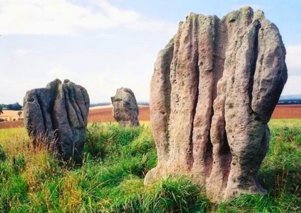
Duddo Five Stones submitted by Bladup on 31st Dec 2013. Duddo Five Stones
(View photo, vote or add a comment)
Log Text: Duddo Five Stones, Northumberland: We had three tries at reaching this stone circle, until we discovered the actual, relatively new 'permissive path'. Our first attempt was using the footpath to the north of the stones, but the footpath had been ploughed out and we had to retrace our steps. Then we used the marked footpath which ran from NT 93907 42659, through the Duddo Farm cottages onto open land full of wild flowers, to NT 93495 43489, where we could see the stones atop a small rise in the field. Andrew walked further on to see if there was a footpath from the north/north east, but nothing, so we decided to follow the tractor tracks through the wheat field, to NT 93084 43470, where we spotted a line of marked canes and a proper path through the crop to the stones – this was the last part of the permissive footpath, which we followed up to the stones.
Stan Beckensall is certainly right in saying this is a spectacular site – the views all around are amazing, and far-reaching. The stones are very attractive, with their very fluted profiles.
There is an interpretation board (put up by DEFRA, facing away from the stone circle, at NT 92968 43718.
I took my time photographing the stones from different angles, and each individual stone. I did manage to catch the four cup marks on the eastern most stone, but how ERA/NADRAF spotted these amongst the natural features, I’m not sure!
We followed the permissive footpath all the way back down to the road, to the west of the village, running from NT 93221 42619 all the way to the stones. There were a number of cars parked here (there wasn’t when we drove past the first time), together with a small sign saying ‘stone circle’ (which I’d missed) and also a sign explaining about the permissive footpath).
St Mary's Well (New Etal)
Trip No.137 Entry No.2 Date Added: 12th Jun 2019
Site Type: Holy Well or Sacred Spring
Country: England (Northumberland)
Visited: Yes on 29th May 2019. My rating: Condition 1 Ambience 3 Access 4
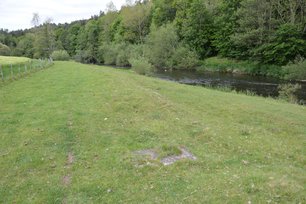
St Mary's Well (New Etal) submitted by Anne T on 12th Jun 2019. All that can be seen now of St Mary's Well is the rectangular slab inset into the grass. This is a natural spring, attributed to St Mary, the water being now piped into the River Till to its eastern side. View as approaching the well head from the western side of the ford across the River Till.
(View photo, vote or add a comment)
Log Text: St Mary's Well, New Etal: The ford across the river from Etal village was pretty high, so we decided not to chance wading across it, but drove round to New Etal and used the farm tracks to walk back down to the western side of the ford to find the remains of this chantry chapel and well.
No signs of the chantry chapel - the foundations are now mostly under the river. All that remains of the well is a rectangular concrete slab with a modern small drain cover at its western side and an access hole to the side nearest the river.
It is a peaceful spot and worth the walk, even though there wasn't a lot to see.
High Moorland Visitor Centre
Trip No.136 Entry No.1 Date Added: 12th Jun 2019
Site Type: Museum
Country: England (Devon)
Visited: Yes on 17th May 2019. My rating: Condition 4 Ambience 3 Access 4
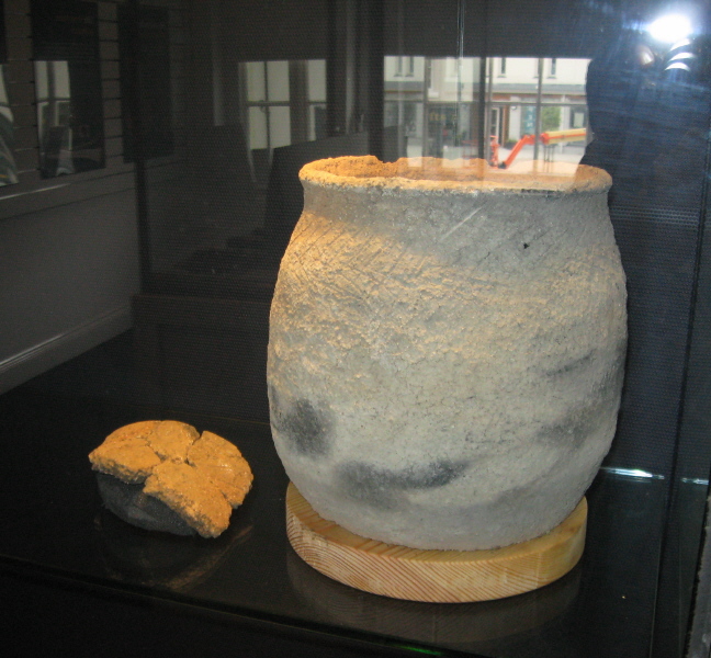
High Moorland Visitor Centre submitted by AngieLake on 5th Feb 2011. A modern replica of a pot from the recent Bellever hut circle excavations. Made by a local lady potter and displayed in the 'Going for Bronze' exhibition in summer 2010.
(View photo, vote or add a comment)
Log Text: Princetown Visitor Centre, second visit: We had arranged to meet one of Sandy G's intrepid Dartmoor Explorers here at around 10.30am, to have a final look around before starting our journey back home. .
I confess to being really disappointed with this Centre as there was only the cast of a standing/inscribed stone and a prehistoric trackway. There were lots of information banners and photographs. The main entrance was really a shop front for cards, maps, books and guide books. I photographed the stone then we left to start the journey home.
The centre was advertising an exhibition due to arrive shortly.
Holy Well (Belstone)
Trip No.132 Entry No.14 Date Added: 9th Jun 2019
Site Type: Holy Well or Sacred Spring
Country: England (Devon)
Visited: Yes on 13th May 2019. My rating: Condition 3 Ambience 4 Access 4
Holy Well (Belstone) submitted by KiwiBetsy on 29th Aug 2006. This is a curative spring located near St Mary’s Church. The spring is protected by several large granite rocks.
(View photo, vote or add a comment)
Log Text: Belstone Spring Head: From the village green, we decided to walk to the well, following the lane past the church and turning right (ESE) onto the common ground/moorland.
Located almost immediately opposite a large pub, and just down slope, this was a lovely location which attracted families and dog walkers.
No water flowing at the time of our visit (the well chamber/basin was just muddy with nettles and ferns growing in it) but there were pools of water bubbling from the ground around it. Some of the ground was fairly boggy, but I managed to get close enough to look in the well chamber.
Belstone Ring Cross
Trip No.132 Entry No.13 Date Added: 9th Jun 2019
Site Type: Ancient Cross
Country: England (Devon)
Visited: Yes on 13th May 2019. My rating: Condition 3 Ambience 4 Access 4
Belstone Ring Cross submitted by hoya105 on 23rd May 2019. Inside St Marys Church, in the lovely village of Belstone with its Holy Well and great pub!
(View photo, vote or add a comment)
Log Text: Ring headed cross at St Mary The Virgin, Belstone: A lovely little village, with not only the ring headed cross in the church but the Coronation Stone and the old stocks on the village green.
The church has a lovely atmosphere, tucked away to the west of the little village shop cum pub. The church had a slim guide book which made interesting reading, and I went through it during our visit to make sure we didn’t miss anything special.
The ring-headed cross is against the south wall of the church, near where the nave and sanctuary join. It’s base had been covered with an Easter scene.
We wandered back to the village green and had tea and cake in the Old Schoolroom Tearooms. This was to be my first experience of “toilet twinning” – there were photos of toilets in other countries that the tearoom toilet had been twinned with – brilliant!)
Belstone Boundary Marker
Trip No.132 Entry No.12 Date Added: 9th Jun 2019
Site Type: Marker Stone
Country: England (Devon)
Visited: Yes on 13th May 2019. My rating: Condition 3 Ambience 3 Access 5

Belstone Boundary Marker submitted by Anne T on 9th Jun 2019. Having parked down the narrow lane just to the west of this boundary stone, this was my first view of it as I approached the road junction.
(View photo, vote or add a comment)
Log Text: Belstone Boundary Marker: Only 1km from the Sticklepath Boundary Stone, this supposedly pre-Conquest stone at the junction of the B3260 and a minor dead-end road which goes north east to a farm.
I got some strange stares from the cars as I photographed this stone, which is no longer on the parish boundary, presumably to accommodate road improvements. Had it not been for the busy road, this would have been in a gloriously peaceful countryside location, with lovely views northwards (the hedge to the south was too tall to see over).
I think the description in the Pastscape entry has been confused with the Sticklepath BS, near Lady Well, as this stone is triangular in shape and the only marking we could see was a partial bench mark on its front.
The acute angle of the minor road junction with the B3260 made the turn right out of the busy road a little tricky, but possible after waiting for a sufficiently large gap in the traffic.
Sticklepath Boundary Marker
Trip No.132 Entry No.11 Date Added: 8th Jun 2019
Site Type: Marker Stone
Country: England (Devon)
Visited: Yes on 13th May 2019. My rating: Condition 3 Ambience 3 Access 4
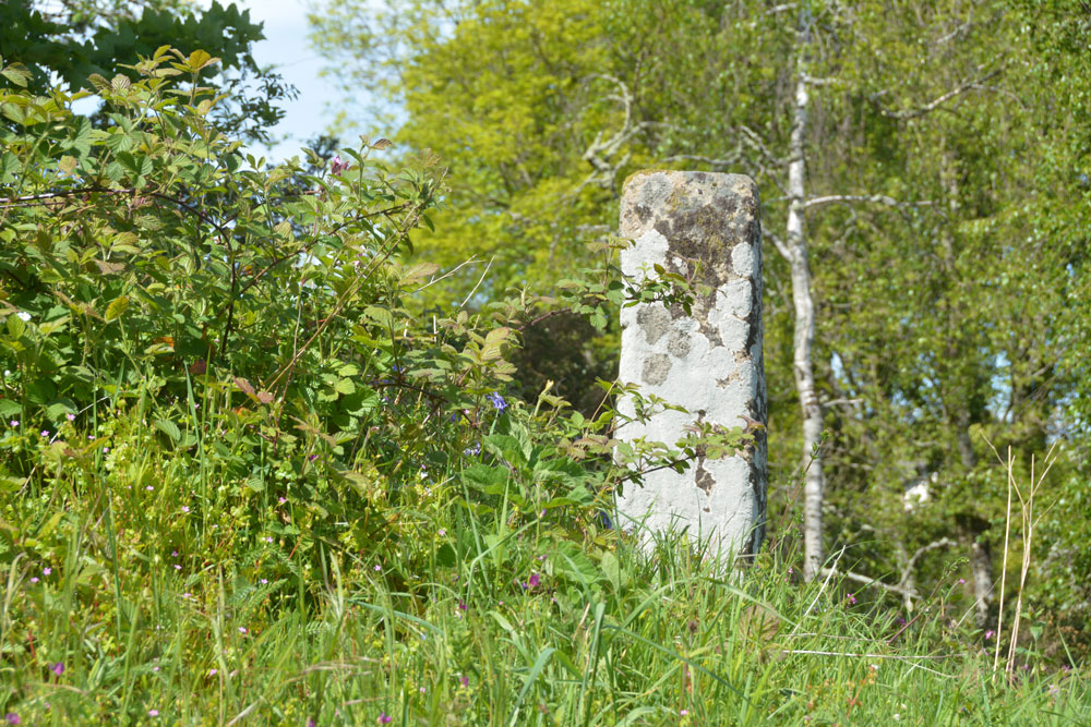
Sticklepath Boundary Marker submitted by Anne T on 8th Jun 2019. The southern face of the cross, which had a cross carved in relief upon it. We were unable to make out any carvings at the time of our visit.
(View photo, vote or add a comment)
Log Text: Sticklepath Inscribed Boundary Stone: This stone is only within 20m of Lady Well, separated by a minor road junction. At the time of our visit, the ambience was spoilt by roadworks which had been set up next to, and almost up to it.
With the stone sitting on top of a retaining wall between the pavement and the main road running through Sticklepath, and a footpath running up slope to its WSW side, Andrew stepped onto the bank and photographed all sides of it for me at close quarters.
Despite peering closely at each side of the stone, we were unable to make out any clear carvings on it at all. The only thing that was clear was the hole for the ball finial which topped the stone at some time in its past.
Lady Well (Sticklepath)
Trip No.132 Entry No.10 Date Added: 8th Jun 2019
Site Type: Holy Well or Sacred Spring
Country: England (Devon)
Visited: Yes on 13th May 2019. My rating: Condition 4 Ambience 2 Access 5
Lady Well (Sticklepath) submitted by KiwiBetsy on 29th Aug 2006. The Lady Well invites visitors to 'Drink and be thankful.'
(View photo, vote or add a comment)
Log Text: Lady Well, Sticklepath: This well is right beside the road. The grid reference given by Pastscape must be the original site of the well, as it actually is at SX 63904 94124.
The ambience of the well was dreadful at the time of our visit, as it sat immediately next to a set of roadworks, and also in deep shade at the time of our visit. Pleased to have seen it, and ticked it off our list, but that’s about all.
The boundary marker is nearby, just up hill, literally on the other side of the road junction.
