Contributory members are able to log private notes and comments about each site
Sites Anne T has logged. View this log as a table or view the most recent logs from everyone
Menzion
Trip No.5 Entry No.2 Date Added: 14th Aug 2016
Site Type: Standing Stones
Country: Scotland (Scottish Borders)
Visited: Yes on 10th Aug 2016. My rating: Condition 2 Ambience 3 Access 5
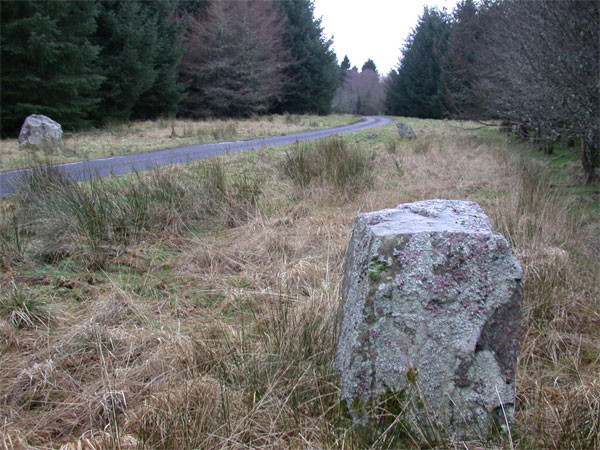
Menzion submitted by nicoladidsbury on 28th Jan 2005. This photo tries to capture the group of three stones, that make up the Menzion site.
This is a beautifully, quiet place. The stones are not very big, less than a metre high, but remarkable because they are absolutely covered in lichens, as are the branches of the over hanging trees. A sure sign of the purity of the air.
(View photo, vote or add a comment)
Log Text: Menzion Stones, Tweedsmuir: I confess to being really confused about this site (not too difficult, really!). Whilst the map showed three standing stones in close proximity at the sides of the road (2 at the western side, 1 on the eastern side) we could only find 2, one on either side of the road. Of the photos on the Portal, we couldn’t find the square topped one. Somehow we’d managed to misplace our GPS, so I felt a bit helpless and frustrated at having driven all this way and missed some of what we’d come to see.
According to the Canmore site, the grid references are NT 0952 2397, NT 0949 2398, NT 0953 2399. Getting out of the car into the ‘Scotch Mist’, I walked up and down the grass verges, peering into the tall undergrowth, for a couple of hundred yards trying to find the location of the third stone. We saw the stones at NT 0952 2397 and NT 0949 2398. The latter was almost hidden by a long, low conifer branch.
Had the sun been out, there would have been great views down to the River Tween to the north-west.
Altar Stone, Stobo
Trip No.5 Entry No.4 Date Added: 14th Aug 2016
Site Type: Standing Stone (Menhir)
Country: Scotland (Scottish Borders)
Visited: Yes on 10th Aug 2016. My rating: Condition 2 Ambience 3 Access 5
Altar Stone, Stobo submitted by austenjohnreid on 5th May 2010. Site in Scottish Borders Scotland
(View photo, vote or add a comment)
Log Text: Altar Stone, near Stobo, Scottish Borders: This stone is clearly marked on the map and features on the Portal, but I can find out nothing about it on Canmore or other web sites.
From Tinnis Castle, driving up the B712 through Drumelzier and Drumelzier Haugh, just past Dawyck Botanic Garden, a small road turns sharp left up through a hamlet called ‘Altarstone’. Opposite the farmhouse, hidden beneath tree branches at the edge of the road is the altar stone Intriguing Need to find out more about this.
Dreva Craig
Trip No.5 Entry No.5 Date Added: 18th Aug 2016
Site Type: Standing Stone (Menhir)
Country: Scotland (Scottish Borders)
Visited: Yes on 10th Aug 2016. My rating: Condition 2 Ambience 4 Access 4
Dreva Craig submitted by austenjohnreid on 29th Apr 2010.
the east side of the hill is littered with boulders & longstones, there is also some remains of a stone age stuff too much to photograph.
(View photo, vote or add a comment)
Log Text: Dreva Craig, hillfort and settlements, Scottish borders: OK, so it rained last year on my birthday. This year, the rain was equally as torrential, so we hopped from site to site. This was our last stop of the day, after (trying to visit) Tinnis Castle/Hillfort and Altarstone. There is a parking space for one or two cars next to the gate to the field, and a stile over the fence, although it proved easier to open the gate. Tramping through the knee high undergrowth, it was easy to reach the rocky outcrop on the ridge leading to the fort itself, but the surface of the rock was so wet it was quite treacherous. Husband would have been happy to continue, but I wimped out when I spotted the huge bull 50 yards away, opting to take a few photographs and retreat to the warmth (and safety) of the car. We plan to come back to this area when the weather is drier. This really looks like a fascinating site, with lumps and bumps on both sides of this minor road. The Canmore record tells me that there is a fort (photographed), defended by two stone walls, alongside three settlements. Had the sun been out, there would have been really fantastic views down to the River Tweed to the south.
St Helen's Well (Great Asby)
Trip No.6 Entry No.3 Date Added: 2nd Oct 2016
Site Type: Holy Well or Sacred Spring
Country: England (Cumbria)
Visited: Yes on 11th Sep 2016. My rating: Condition 3 Ambience 4 Access 5

St Helen's Well (Great Asby) submitted by MisterBus on 12th Oct 2010. The beautifully restored well in the centre of the village is in full flow. The well was restored by villagers in 2008.
(View photo, vote or add a comment)
Log Text: St Helen's Well, Great Asby, Cumbria: This was our third stop of the day. From (confusingly) St Helen’s Well at Newbeggin-on-Lune, we took a right hand turn back onto the A685 then the next turn right taking the minor road between Crosby Garrett Fell and Ravenstone Moor. Turning right at the T-junction at Middle Bank, we followed the road through Little Asby to Great Asby. We parked next to the little alms cottage about 20 metres to the north west of this well. At first, all I could see was a modern stone wall with some horribly concrete shapes on it’s top, with the Asby Beck beyond. Walking towards the modern stone wall, a huge rush of water could be seen running into the beck, coming from no apart source—just straight out of the ground.
The well itself has a square pool into which water emerges. As we watched, the flow of water was sufficient to move the sand forming the base. Most intriguing.
With a village this old, we decided to investigate the local church, St. Peter’s. The modern building is of no great age, although the ‘short account’ of the church says that the site may have been used from the 7th century onwards (as Peter was a common dedication from this time on).
The Pastscape record for this well says this well "was formerly seated round and of great repute for the medicinal properties of its waters. Consists of a deep pool, approximately 4.0m square, contained by a stone wall, with a drain-off channel at its eastern corner. It is not apparent whether the pool is fed by a natural spring or a piped supply, as the point of issue is below water level. A modern wall partially surrounds the well. "
St. Helen's Well (Newbiggin-on-Lune)
Trip No.6 Entry No.2 Date Added: 14th Feb 2017
Site Type: Holy Well or Sacred Spring
Country: England (Cumbria)
Visited: Yes on 11th Sep 2016. My rating: Condition 2 Ambience 3 Access 5
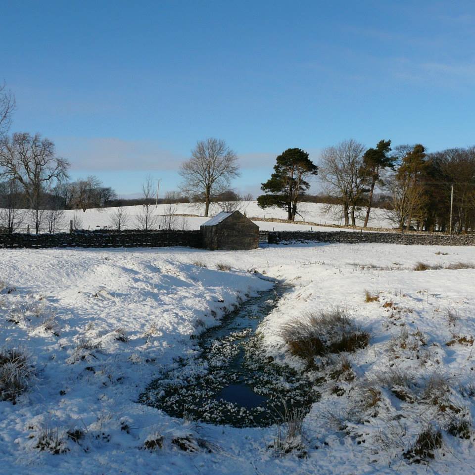
St. Helen's Well (Newbiggin-on-Lune) submitted by HeronEye on 2nd Mar 2014. St Helen's Well, Newbiggin on Lune.
The source of the River Lune.
This well pool is situated next to the mound of chapel that once stood here (picture left).
(View photo, vote or add a comment)
Log Text: St Helen's Well, Newbeggin-on-Lune, Cumbria: After seeing the Loki Stone at Kirby Steven, we followed the A685 south and west to Newbeggin-on-lune. St Helen’s Well is about 50 metres to the north of the A685 (called Fell Lane at this point). It sits almost at the junction where Chapel Butt Lane splits into two. There is parking for about three cars at this junction.
We initially took the left hand fork, walking down to where a footpath sign pointed right over the field containing the well, just before a field gate. Climbing the small stile, walking over the footbridge, we were confused as to where the well was. We understood this well was supposed to be the source of the River Lune, but there are small streams which run to the north/north east which carried a strong flow of water (there must have been a large amount of rain here recently, as the ground was incredibly boggy with large puddles across the paths, as opposed to being dry where we live). Wading through the puddles through the field gate, there was a large boggy area (complete with bull) which appeared to be the lowest point in the area, and the source of the water flow.
Retracing our steps, we asked a local lady who was walking her dog. Despite having visited this area for 34 years, she hadn’t heard of this well. Walking down the right hand lane, the well can be found by walking down the right hand side of Chapel Butt Lane (heading towards Friar Bottom Lane), with the pool becoming visible just after the first bend.
Hollin Stump Cairn
Trip No.6 Entry No.4 Date Added: 2nd Oct 2016
Site Type: Cairn
Country: England (Cumbria)
Visited: Yes on 11th Sep 2016. My rating: Condition 3 Ambience 4 Access 3
Hollin Stump Cairn submitted by HeronEye on 14th Mar 2014. Looking East to Hollin Stump cairn from the footpath to Gaythorne Plain ring cairn.
(View photo, vote or add a comment)
Log Text: Hollin Stump Cairn, Gaythorp Plain, Cumbria: From St Helen's Well at Great Asby, we headed south south west, following the single track road to ASby Winderwath Common, were the metalled carriageway turned west across Gaythorne Plain. We parked by the cattle grid on opposite Linglow Hill, where a dog walker had taken up much of the dry parking area and was waiting for his 2 lively terriers to wear themselves out tearing across the grass.
We hadn’t spotted a gateway into the field containing Hollin Stump Cairn from the road, so followed the bridlepath south. There was a gate into the field about a quarter mile from the road, but there was a herd of large cows (and a bull) surrounding the cairn, so we only go to view this from a distance.
We carried along the bridlwway to find the Gaythorn Plain Ring Cairn/Stone Row (not sure we found it, need to process the photos). The latter was visit 7/5 (not yet logged).
Mauley Cross
Trip No.7 Entry No.1 Date Added: 2nd Oct 2016
Site Type: Ancient Cross
Country: England (Yorkshire (North))
Visited: Yes on 1st Oct 2016
Mauley Cross submitted by vagabondnma on 13th Mar 2007. Mauley Cross standing on a raised area of land by the forest road backed by a plantation.
(View photo, vote or add a comment)
Log Text: Mauley Cross, north of Stape, North Yorkshire: Chrispy's directions were spot on - thanks! Trust us to arrive on the day of a rally, with all the cars coming in the opposite direction. Being off-stage, they needed to stick to the speed limit and we found ourselves constantly pulling in to passing places. It was fun to see the different cars.
Arriving at the junction of the metalled road (Keys Beck Road) which runs north through Stape then up over the moors and the forest track (Brown Howe Road) we came across ‘road closed 1st October 2016 due to the Trackrod Rally). There were some marshalls sitting at the wide entrance to this forest track, so we parked between their cars and wandered 50 metres or so up the track to find this cross, making sure to avoid the rally cars which zoomed down every minute or so. After a few minutes a doctor's car zoomed up the track past us and we took advantage of a lull in the stream of cars (there must have been an accident - hope everyone was OK).
Sitting a couple of metres off the forest track, the grass around the cross has been cleared and a couple of tributes sit at its base.
There are two Mauley Crosses listed on the ADS database, the second being just east of Saltergate (this is a similar cross, made out of one piece of sandstone, forming a boundary marker between the parishes of Allerston and Lockton at grid reference SE86679493.
Old Wives' Well
Trip No.7 Entry No.2 Date Added: 2nd Oct 2016
Site Type: Holy Well or Sacred Spring
Country: England (Yorkshire (North))
Visited: Yes on 1st Oct 2016. My rating: Condition 3 Ambience 4 Access 5
Old Wives' Well submitted by vagabondnma on 13th Mar 2007. A close-up of the well. The inscription (grafitti?) on the capstone is not easily visible).
(View photo, vote or add a comment)
Log Text: Old Wives' Well, just south of Mauley Cross, near Stape, North Yorkshire: With this well only 223 metres south of the Mauley Cross, we decided to walk down the narrow metalled road ((Keys Beck Road) to the well. Again, Chrispy’s directions were spot on. This time, the rally cars were back, appearing every minute or so and we had to ensure we were visible to the drivers at all times (sometimes difficult with the bracken at the sides of the road being so high). Walking southwards back down towards Stape Village, reaching the first passing place on the left hand side of the road, a small track leads through the grass. About 20-30 metres into the wood we glimpsed a wooden rail which partially surrounds the well, then the well itself came into site.
With a simple stone built ‘hood’ over it, into which there is writing carved into the lintel, this is a very enigmatic spot. The well basin was full of water and a small tickle cut its way through the peat floor of the wood, heading south west down hill towards the road.
There were plenty of old ribbons and scarves (even a sock!) tied to the trees around the well.
According to the Pastscape Record for this monument, number 60532, the lettering on the lintel reads: "Nattie Fonten L M Natalis" (Roman governor of 3 provinces 120AD).
Rawcliffe Howe
Trip No.7 Entry No.3 Date Added: 2nd Oct 2016
Site Type: Cairn
Country: England (Yorkshire (North))
Visited: Yes on 1st Oct 2016. My rating: Condition 2 Ambience 2 Access 5
Rawcliffe Howe submitted by vagabondnma on 13th Mar 2007. Rawcliffe Howe as seen from the road - which allows you to see its profile. Unfortunately the embankment cuts right through it. So some of it is missing.
(View photo, vote or add a comment)
Log Text: Rawcliffe Howe, south of Stape Village, North Yorkshire: No entry exists for Rawcliffe Howe on the ADS, but does on Historic England. From Old Wives’ Well, driving southwards back down through the Village of Stape, we came to a four way cross-roads. Parking in a small layby just as we turned into Low Moor Road, where on the opposite side of the road a footpath runs through the wood leading to Rawcliffe Banks. I used the photographs from the mobile Portal site to help locate this.
This round barrow sits right on the edge of the road opposite the entrance to Low Moor Road and has clearly been cut through by the road. Trying to photograph it was very tricky as the rally cars were coming in groups thick and fast, and at one point I jumped further onto the verge to avoid a car that nearly missed the turning!
We managed to get photographs from various angles, although if I hadn’t known this was a site from the Portal would have missed it entirely.
Black Howe (Rawcliffe)
Trip No.7 Entry No.4 Date Added: 2nd Oct 2016
Site Type: Cairn
Country: England (Yorkshire (North))
Visited: Yes on 1st Oct 2016. My rating: Condition 2 Ambience 2 Access 5
Black Howe (Rawcliffe) submitted by vagabondnma on 13th Mar 2007. The bracken covered Black Howe. I have another picture that is even less clear!
(View photo, vote or add a comment)
Log Text: Black Howe round barrow, west of Newton-on-Rawcliffe, North Yorkshire: Just 800 metres from Rawcliffe Howe, travelling east along Rawcliffe Road, Black Howe round barrow can be found.
There is a small layby (which says no parking) but was large enough for several cars, so we parked and hopped out to look.
The barrow was visible as a mound through the bracken, but the farmer had blocked the entrance to the field with harvesting machinery, so it was not possible to access the site to see the barrow from the other side (sadly). There were great views across the Pickering valley.
The only information I can (currently) find out about this barrow is from the Ancient Monuments website, which says: "Traces of an earthwork were noted in the field west of Black Howe in 1949. Field investigation in 1974 found no trace of the feature, the field under pasture", although there is a clear, bracken covered mound at the edge of the field.
St Hilda (Ellerburn)
Trip No.7 Entry No.5 Date Added: 2nd Oct 2016
Site Type: Ancient Cross
Country: England (Yorkshire (North))
Visited: Yes on 1st Oct 2016. My rating: Condition 3 Ambience 4 Access 5
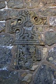
St Hilda (Ellerburn) submitted by kelpie on 24th May 2007. Decorative cross fragment
(View photo, vote or add a comment)
Log Text: Anglo Saxon Cross parts at St. Hilda's Church, Ellerburn, North Yorkshire: From Black Howe, with the light rapidly fading, we decided to go to St Hilda’s in Ellerburn. The Corpus of Anglo Saxon Stone Sculpture has added York and East Yorkshire to their catalogue, and I was able to pull all up the Ellerburn pages on my phone prior to visiting. Sadly, there was no signal in the village so it wasn't possible to view them whilst at the location.
Ellerburn is a very pretty hamlet and the church of St Hilda’s looks like an old manor house that has been converted into a church. Pulling into the layby by the church, there were signs asking for a £3 parking fee (but free if visiting the church).
Entering the churchyard through a lych gate, three sheep were cropping the grass. A stile led from near the path into the churchyard (the gate was padlocked) – to be used at your own risk, the sign said. Sadly, the church was already locked up when we arrived (well it was 6pm) so we missed the stones inside. However, we were able to wander round and pick out the cross parts built into the walls.
The Corpus lists nine stones, 9a and 9b of which are the edges of two hog-back tombs. We wandered up the pretty little stream running opposite the church. A noisy campsite at the farm opposite spoiled the peace of the hamlet, but it was still very pretty and worth visiting.
Wandering around the graveyard, I spotted the grave of Isaac Newton and his wife Mary (no, not the famous one, but still made me smile).
Note: the church site says the church is only open between 10am and 4pm each day.
Five Kings
Date Added: 10th Jan 2017
Site Type: Stone Row / Alignment
Country: England (Northumberland)
Visited: Couldn't find on 1st Jan 2017. My rating: Access 3

Five Kings submitted by Strider on 4th Feb 2003. Five Kings, Northumberland
NT955001
Alignment of four large, irregular stones - the fifth may have fallen but I could not be certain.
(View photo, vote or add a comment)
Log Text: Five Kings, near Grasslees, Northumberland: The easiest access looked as if it was from the footpath near Ovenstone Plantation off the B6341, just past Grasslees. Parking off the road at the entrance to the footpath, we headed off up the track - easy walking at this stage. 100 metres up the track there was a gate/stile with two display boards. Neither bore any similarity to each other, or to the OS map. We had intended walking up the footpath to its fork, 100 metres further up, then take the right hand fork following the stone wall up past The Long Chirn and Woodhouses to the Five Kings. Sadly (presumably being military land) this part of the footpath no longer exists and the walking was difficult (very tussocky, marshy ground). When the heavens opened (despite the weather forecast saying it would be fine!), we contemplated finding a second footpath through Dueshill Farm but it would be dark by the time we reached the stone row, so we decided to go somewhere else and headed back to the car and try another route on a better day. I was so disappointed, as this was a stone row I'd loved to have seen, but the Tosson Tower and Lordenshaw had to suffice for this afternoon.
Lordenshaw Hillfort
Trip No.8 Entry No.1 Date Added: 10th Jan 2017
Site Type: Hillfort
Country: England (Northumberland)
Visited: Yes on 1st Jan 2017. My rating: Condition 3 Ambience 4 Access 4
Lordenshaw Hillfort submitted by DrewParsons on 2nd Oct 2011. View of the second of the two entrances. September 2011.
(View photo, vote or add a comment)
Log Text: Lordenshaw Hillfort, Northumberland: after an abortive trip to the Five Kings stone row, via Tosson Tower Bastle/Tower House, we parked at the main Lordenshaw's car park and headed northwards up the hill towards the hillfort. It was almost 3pm on new year's day and dusk was starting to fall, together with a biting wind and sleet flurries. We've been here before with our daughter and son-in-law on a glorious (but still windy) autumn afternoon, but didn't take any photographs at the time. Wanting to see Channel Rock and other rock art before darkness fell, we didn't linger too long in the hillfort. The defensive banks and ditches are still remarkably clear and the views, particularly down to Rothsbury were great. On the way back from Channel Rock, to the north west of the hillfort, I spotted what looked like cairns. There was an old boundary feature and in the interior of the hillfort, following the pathway to Main Rock, we spotted the stone ring bases of three round houses. Would love to go back on a warm summer's evening!
East Lordenshaw Channel Rock
Trip No.8 Entry No.2 Date Added: 10th Jan 2017
Site Type: Rock Art
Country: England (Northumberland)
Visited: Yes on 1st Jan 2017. My rating: Condition 3 Ambience 4 Access 3
East Lordenshaw Channel Rock submitted by DrewParsons on 2nd Oct 2011. September 2011.
(View photo, vote or add a comment)
Log Text: Channel Rock, Lordenshaw, Northumberland: At the main Lordenshaw car park, there is a display board with a QR reference which I scanned to get me through to the Newcastle University Rock Art Mobile site. This is the first time I’ve been able to use this, as I had a good mobile signal, and found it great.
Their directions to Channel Rock are: “From the top of the hillfort, facing towards Rothbury down the valley, continue through the hillfort to your right. At the waymarked hillfort exit (65m) follow the left hand path. When you reach another waymarker (135m) turn off the path to the right, down the slope. You should see an expanse of white rocks straight ahead (70m).”
We carried on northwards through the hillfort, dropping down the slope to the north, past a waymarker, then headed right. At first difficult to find, as the light grey/whiteish Channel Rock sits within a rocky landscape, once spotted, its easy to identify and sits right on the edge of the hill; the cup marks and channel can be clearly seen.
Nearby is an impressive undercut rock, rounded by water. Brilliant site, sitting well below the crest of the hill/hillfort.
West Lordenshaw Main Rock
Date Added: 10th Jan 2017
Site Type: Rock Art
Country: England (Northumberland)
Visited: Yes on 1st Jan 2017. My rating: Condition 3 Ambience 4 Access 4
West Lordenshaw Main Rock submitted by DrewParsons on 2nd Oct 2011. One of the deep cup and ring marks on this rock. September 2011.
(View photo, vote or add a comment)
Log Text: West Lordenshaw Main Rock, Northumberland: From Channel Rock, we walked back through the hill fort, stopping to admire a possible cairn field and three roundhouses next to the path. Main Rock generally had other visitors around it, but by this time it was starting to get really quite dark and we could spot heavy rain heading to us from across the valley in Rothsbury. I wanted to see both Main Rock and Horseshoe Rock before heading home, but time was too short and we only made it to Main Rock before torches would have been needed to see our way back to the car.
Having also visited the Portal site and seen how many other pieces of rock art there are here, I was regretting loss of our GPS last year on a Level 3 survey with the archaeology group – definitely need to replace it!
Needed to use the flash to get any photographs at this point. Some impressive motifs. Would have liked longer (and warmer weather) to sit and study this rock. A repeat visit (with GPS) to Lordenshaw is on my 'must' list!
Lowhouse
Trip No.9 Entry No.6 Date Added: 15th Feb 2017
Site Type: Stone Circle
Country: England (Cumbria)
Visited: Yes on 12th Feb 2017. My rating: Condition 3 Ambience 3 Access 4
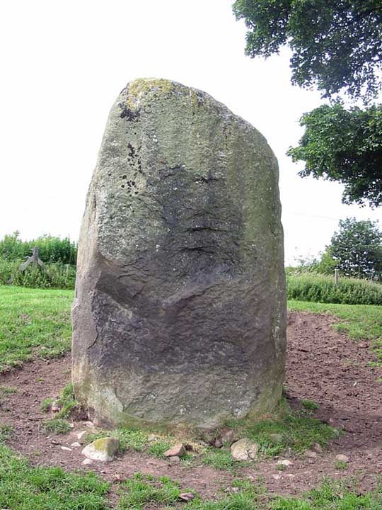
Lowhouse submitted by stu on 16th Jul 2004. Kitchenhill Bridge Stone (Lowhouse?), NY4961 3434.
Standing by the West Coast Mainline, this is a massive stone at least 3m tall. Not marked on the O.S maps.
(View photo, vote or add a comment)
Log Text: Lowhouse/Holme Head/Kitchenhill Standing Stone, Penrith, Cumbria: From Newbeggin, heading back up the M6, leaving at junction 41, turning right onto the B5305 and taking the first exit off the roundabout, we headed up the minor road signposted to Calthwaite. Where the road divides at Kitchenhill Farm, we turned right, heading over the railway line, then immediately over the small bridge over the River Petterill. At grid reference NY 49802 34135 there is a left hand turn on the bend, leading down to a small area of land by the river, used by the farmer for storing hay. There is room here for one car to park at the entrance. We walked back the short distance over the bridge over the river and went to look over the gate into the field. At first, in the gathering dusk, we couldn’t see anything, but then at the far end of the field, sheltered by a large tree, we spotted this huge grey stone.
The field is guarded by a barbed wire topped gate. I don’t like trespassing, but there was nothing in the field, so we let ourselves gingerly in and followed the tractor trail over the grass to the stone. It is huge. I spotted what seemed like other smaller (grey) stones in the base of the red sandstone wall to the right-hand side of the field. Getting closer to the stone, it sits on (what was) a lovely spot (pre railway line), overlooking the gently meandering river below.
Andrew was keen to try and get sight of two other stones in the area (and another I’d spotted travelling south on the M6 on the way down), so we drove to Plumpton, slightly further north, stopping near Plumpton Wall Farm to peer over the fields, but could see nothing. We retraced our route and headed off towards Calthwaite, stopping at the entrance to Hallrigg to peer eastwards over the fields. With the sleet hammering in our faces, Andrew got the binoculars out and spotted a stone next to Calgarth Plantation at grid reference NY 48253 37527. Looking on UK Grid Reference Finder, I couldn’t see any sign of it, although this is an old map on the Modern Antiquarian web site which would be worth investigating.
Skirsgill Standing Stone
Trip No.9 Entry No.1 Date Added: 13th Feb 2017
Site Type: Standing Stone (Menhir)
Country: England (Cumbria)
Visited: Yes on 12th Feb 2017. My rating: Condition 2 Ambience 3 Access 5
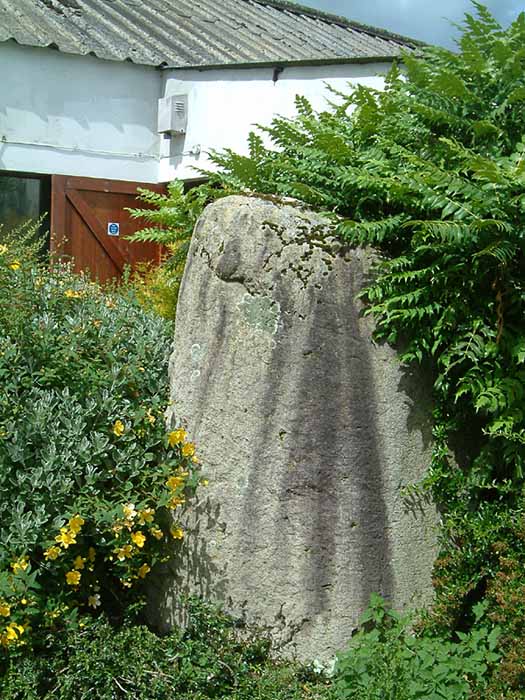
Skirsgill Standing Stone submitted by stu on 16th Jul 2004. NY5098 2874.
On the Skirsgill industrial estate near Penrith. Stone stands at the rear of the Liliput Lane factory.
(View photo, vote or add a comment)
Log Text: Skirsgill Standing Stone, Penrith: Situated in Skirsgill Business Park, just to the west of the southern part of Penrith, we’ve tried visiting this stone before, but never found it.
From Penrith, heading west across the M6 on the A66 towards Ullswater, take the very first turn into the Skirsgill Industrial Estate (easy to drive past, as it has a very short feeder lane into it). Follow the one way system into the industrial estate (note the intriguing thatched building to your left) and continue straight ahead between the two sets of industrial units. After several hundred metres, you will see a dead end with a gate leading into the field, an CrossFit Cumbria to your left. Parking can be difficult during the week, but plenty of spaces during the weekend. Walk along the dead end road towards the field, with the CrossFit building to your left. The standing stone can be found immediately at the end of this building. Was the building built to accommodate the stone, or has the stone been relocated to form part of its garden?
The face of the stone nearest to the building appears to have been quarried in more recent times, as the face is ‘squared off’. There is some modern grafitti on it.
Not the best of locations, but certainly intriguing! Could only find the Historic England listing – nothing in Pastscape.
Mossthorn Long Cairn 2
Trip No.9 Entry No.3 Date Added: 13th Feb 2017
Site Type: Cairn
Country: England (Cumbria)
Visited: Yes on 12th Feb 2017. My rating: Condition 3 Ambience 3 Access 5
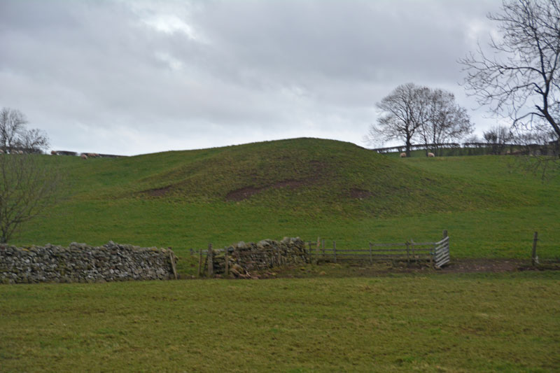
Mossthorn Long Cairn 2 submitted by Anne T on 13th Feb 2017. The long cairn at grid reference NY 48289 30440, taken from the layby outside The Wreays on the minor road from the A66 to Greystoke.
(View photo, vote or add a comment)
Log Text: Long Cairns near Mossthorn Farm, near Sewborwens Standing Stones: From Sewborwens Standing Stone(s), we drove westwards along this minor road, through the roadworks currently there, and parked in the layby outside The Wreay. The first long cairn is visible in the field immediately opposite.
Crossing the road to photograph this site, the wind chill must have been -5 degrees C, with the occasional flake of sleet. The roadworks had churned up the grass, so I waded through almost ankle deep mud to the stone wall and got a closer photograph.
We didn’t realise there was a second cairn at grid reference NY 48258 30606 until I checked on the Historic England site.
Given we want to come back and track the standing stones in Newbeggin Village at some point, I’m going to write to the farm to ask permission to walk the fields to see both long cairns at closer quarters.
Sewborrans Stone
Trip No.9 Entry No.2 Date Added: 14th Feb 2017
Site Type: Standing Stone (Menhir)
Country: England (Cumbria)
Visited: Yes on 12th Feb 2017. My rating: Condition 3 Ambience 3 Access 4
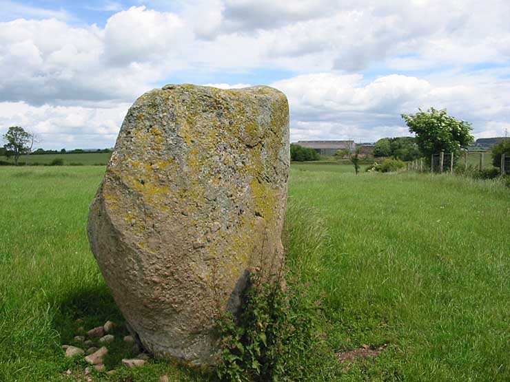
Sewborrans Stone submitted by stu on 16th Jul 2004. NY4884 2999.
1.5m high stone. Visible from the road.
(View photo, vote or add a comment)
Log Text: Sewborwens Standing Stone (and outliers), Penrith, Cumbria: From the Skirsgill Standing Stone, we made our way back on the A66, heading westwards (you can only turn left onto this dual carriageway). Turning round at the next roundabout, heading back to Penrith, we took the first left hand turn down the mnor road leading past the golf driving range and Greystoke Pillar (18th century monument to the 11th Duke of Norfolk). About 1.5 kms down this road from the A66, there is a barn on the right hand side of the road with a small (muddy) layby next to it. There is a gate into the main field to the east of the barn and the standing stone is visible next to the first fence line to the east.
There was nothing in the field, so we kept to its edge to look at the stone. Before reaching the stone, I spotted two more smaller stones in the hedge line, which looked like part of a row or avenue leading to the stone.
Having photographed the stone, I spotted more large stones against the wire fence. This modern fence has been put on top of what looked like an old (medieval?) stone wall line. There were at least three large boulders, two looking like they had been shaped and with flat bottoms, which had been moved against the old wall to clear the field.
An email to Cumbria County Council provided the information: "there are 2 smaller stones which may be related to the larger stone, beside the hedgerow bordering the B5288 and about 120 metres bearing 280 degrees from the major stone. The southernmost stone is c1.08 metres and the northermost stone is c0.75 metres.” They also added that notes from 1973 tell us: “Thompson records the ‘remnants of a stone sepulchural ring at Sewborrans”, but he doesn’t know what the original source was.
Newbeggin Stone Row
Trip No.9 Entry No.4 Date Added: 15th Feb 2017
Site Type: Stone Row / Alignment
Country: England (Cumbria)
Visited: Visited (still working on) on 12th Feb 2017
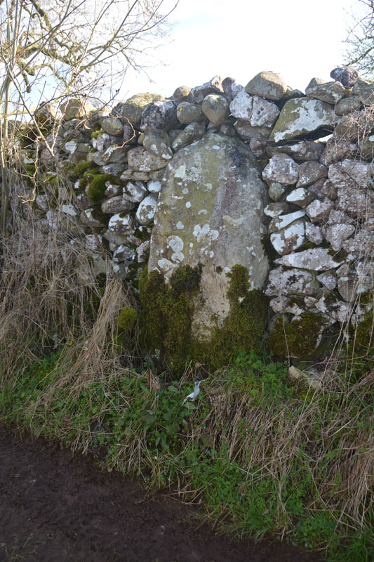
Newbeggin Stone Row (Possible) submitted by Anne T on 28th Mar 2017. This stone is built into a stone wall on a footpath which follows the Carlsike Burn, around Hoghouse Hill to Newbeggin. Located at NY 48058 29531. Note: 3rd April 2017. The Lead Officer for the Historic Environment and Commons says "This is slightly more interesting. I would not like to guess at when this might have been erected."
(View photo, vote or add a comment)
Log Text: Newbiggin Stone Row, near Penrith: See comment on main page. Tried to find. Seen an image of a stone in an enclosure wall but unable to locate. Working on finding exact location and will return!
