Contributory members are able to log private notes and comments about each site
Sites Anne T has logged. View this log as a table or view the most recent logs from everyone
Tullibole
Trip No.109 Entry No.1 Date Added: 11th Nov 2018
Site Type: Sculptured Stone
Country: Scotland (Fife)
Visited: Yes on 31st Oct 2018. My rating: Condition 2 Ambience 3 Access 4
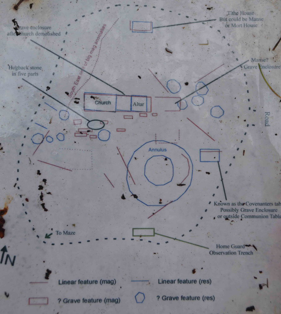
Tullibole submitted by Anne T on 11th Nov 2018. The paper sheets covered by plastic on the information board, propped up by the large memorial surrounded by iron railings, were sodden with rain. I photographed the plan for future visitors in case it became illegible in the near future. This shows where to find the hogback pieces, but beware, we only found what we thought were two pieces, deeply buried under grassy tussocks.
(View photo, vote or add a comment)
Log Text: Tullibole Church Ruins with hogback in five pieces: Our first stop of the day, and as Andrew told me this was a site where 11 witches were tried, condemned and burned, a site I thought would be a good, spooky, start to the Halloween. But, this is essentially a field with a few gravestones sticking out of it, and it turned out the trials had taken place at nearby Tullibole Castle. The remains of the church are there, on the south side buried deep in the grass and turf, but more visible on the northern side, where several courses of stones stick up out of the ground.
There is a display board next to a large monument surrounded by a metal railing and tall conifers, but we had difficulty orientating ourselves to the photos, eventually picking up the display board (which was propped up against the railings, and taking it over to the chest tombs).
We did find one part of the hogback, and possibly a second, but the grass tussocks were so high, we were unable to find any more pieces.
As the information sheets were covered in plastic, but the rain was seeping through, and they are likely to become even more worn and stained, I photographed a couple of them and typed them up for future reference.
Balfarg Riding School mortuary enclosure and henge
Trip No.110 Entry No.3 Date Added: 13th Nov 2018
Site Type: Henge
Country: Scotland (Fife)
Visited: Yes on 1st Nov 2018. My rating: Condition 3 Ambience 3 Access 4
Balfarg Riding School mortuary enclosure and henge submitted by SandyG on 3rd Jan 2015. The reconstructed mortuary enclosure. View from north west (19th April 2014).
(View photo, vote or add a comment)
Log Text: Balfarg Riding School Henge Reconstruction: This now recreated henge is just by the A92, at the end of Old Leslie Road, with part of it seeming to have been cut by the construction of the A92. Traffic streams by constantly.
We arrived with the sun high in the sky and deep shadows, which tested my photography skills. I had expected a circular henge, but this was oval. I didn't pick up any atmosphere at this site at all. Sadly, it was just like walking through some old fence posts set up to cast some interesting shadows.
The information board reads: “You are standing in a revered landscape where ceremonies were performed by generations of prehistoric people. Here is an artist’s reconstruction of how the stone circle looked around 4,000 years ago. By this time it had already been in use for 1,000 years, when it became a place of burial. It stood close to the Coul Burn which then enclosed a wider sacred landscape. The picture shows the site of the Balfarg Henge and timber enclosure in the distance.”
Dogton
Trip No.110 Entry No.5 Date Added: 13th Nov 2018
Site Type: Class III Pictish Cross Slab
Country: Scotland (Fife)
Visited: Yes on 1st Nov 2018. My rating: Condition 3 Ambience 4 Access 4
Dogton submitted by cosmic on 15th Feb 2006. Dogton from East
(View photo, vote or add a comment)
Log Text: The Dogton Cross: With the clocks having gone back an hour on the Sunday before, it was difficult to correctly judge how fast dusk would fall. It was getting a little dark, but whilst we were here, we really wanted to see this stone.
With the roads busy at this time of night, we managed to park just off the road at the entrance to the track leading up to Kinglassie House, just off the B922 and set off up the footpath to find this cross.
The gate into the field the stone was in was an amalgamation of several gates tied together, so it was easier just to step over the tumbled stones by the gate post. Fortunately the field the stone was in had just been harvested, so we walked up through the corn stubble, just as dusk was setting in.
I photographed each face of the cross by leaning over the railings, or poking the camera through the railings, then stitched them together.
The sign on the railings reads: “Dogton Stone. This stone is a free-standing Celtic cross probably 10th century AD. The top and arms of the cross have been destroyed, but the centre boss is still visible on the east face. A horseman is carved below it and there are entwined serpentine animals on the south face. Cared for by Historic Scotland.”
When I got back home and looked at the Canmore records, I was surprised to see the cross and its railings had been, in the not too distant past (photo dated 1927), incorporated into a dry stone wall, no longer there.
Tuilyies
Trip No.111 Entry No.2 Date Added: 14th Nov 2018
Site Type: Standing Stones
Country: Scotland (Fife)
Visited: Yes on 2nd Nov 2018. My rating: Condition 3 Ambience 4 Access 4
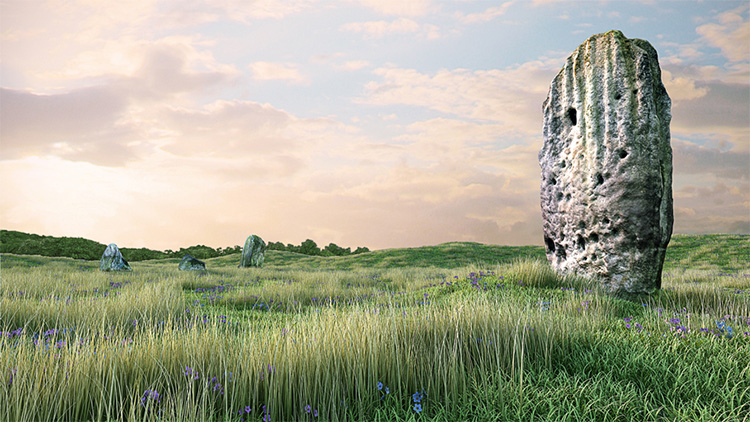
Tuilyies submitted by jonathanknox on 3rd May 2012. Tuilyies 3D model #2 -Tuilyies Standing Stones in Fife, Scotland, part of a digital documentation/visualisation pilot project by Pixogram. Accurate retopologised 3D models from photogrammetry to a +-10mm tolerance.
(View photo, vote or add a comment)
Log Text: The Tuilyies Stone Setting: There is a small layby on the A985, right by the stones, but as there was no direct entrance into the field, we ended up walking along the grass verge down to where the wire fence is jointed to a wooden one. This is by a small clump of trees, at NT 02801 86657, where we succeeded in clambering over the fence.
The stones are set in a very ‘lumpy and bumpy’ field that looks like it has several building platforms and banks within it, but no structures are visible.
The tall stone to the north north west of the setting of three stones is tall and impressive (although thin) with the eastern face peppered in cup marks.
Combined with the three stones to the south south east reminded us somewhat of the stone setting at Kilmartin. I amused myself by standing behind the taller stone trying to line it up with the three smaller ones, but there was always one stone hidden from view, behind the larger stone.
The Firth of Forth glinted in the sunlight to the south. Shame about the proximity to the main road.
Torwood Broch
Trip No.24 Entry No.2 Date Added: 16th May 2017
Site Type: Broch or Nuraghe
Country: Scotland (Falkirk)
Visited: Yes on 13th May 2017. My rating: Condition 3 Ambience 4 Access 4
Torwood Broch submitted by cosmic on 23rd Sep 2005. View across broch to internal room.
(View photo, vote or add a comment)
Log Text: Tappoch/Torwood Broch, West Lothian: I’d wanted to go in search of the 2 boundary stones near Torphinchen, but was over-ruled in favour of the broch at Tappoch. By the time we’d left Torphinchen, the rain really started to come down, but being equipped with waterproofs, and supposedly sheltered by the tall forest trees, we set off anyway.
Parking on Glen Road, close to the footpath, we set off up the public right of way to Denoven (the car park that is mentioned in the main page is now a new house), then took the path which headed off right and up hill into the forest. It was lovely, soft spongy ground to walk on, with all the pine needles forming a soft covering over the prolific bedrock slabs.
Continuing up the hillside, the rain got heavier, but as we reached the broch, the rain stopped for a short period (just long enough for us to explore the broch).
The easiest way to access the interior of the broch is to take the path to your left, walking round the exterior wall of the broch. An internal staircase comes into view, and it’s easy walking down these few steps. Going straight up the hill was definitely for mountain goats! The interior feels roomy and solid, with sturdy, dry stone walls.
The foresters (or others) have clearly been using this structure, as there were the remains of a stone fire pit and recently burnt wood.
Looking closer at the lumps and bumps around the broch, I think there are other structures attached to this site. There was a very steep drop on the broch’s southern side, clearly excellent for defences.
Well worth a visit, even if it took several hours to dry out afterwards!
Traprain Law
Trip No.52 Entry No.4 Date Added: 10th Oct 2017
Site Type: Hillfort
Country: Scotland (East Lothian)
Visited: Saw from a distance on 27th Sep 2017. My rating: Condition 2 Ambience 5 Access 3
Traprain Law submitted by caradoc68 on 14th Feb 2012. Hold on to your hat its windy up there !
(View photo, vote or add a comment)
Log Text: Traprain Law Hillfort, East Lothian: We only saw this from afar. It would have taken too long to climb up and get back down and see the rest of the sites we wanted to see this afternoon. Brilliant view. The farmer’s wife from Standingstone Farm told us there were wild Exmoor ponies living on top (we could see them moving around on the top of the slopes), but their water was at the bottom of the hill.
Packman's Grave (Whiteadder Reservoir)
Trip No.105 Entry No.3 Date Added: 4th Nov 2018
Site Type: Stone Row / Alignment
Country: Scotland (East Lothian)
Visited: Couldn't find
Log Text: Packman's Grave, Whiteadder Reservoir: Despite having the grid reference, we were unable to find anything at this site, which was disappointing. We did find something remarkably similar at NT 62814 64541 - five stones in a kite-;ike shape, not far to the south west of the Mayshield Stone Setting.
Pencraig Brae
Trip No.52 Entry No.2 Date Added: 9th Oct 2017
Site Type: Standing Stone (Menhir)
Country: Scotland (East Lothian)
Visited: Yes on 27th Sep 2017. My rating: Condition 3 Ambience 4 Access 4
Pencraig Brae submitted by minteddy on 14th Dec 2006. Pencraig Hill. This is a tall standing stone (about 3 metres?) in a field to the north of A1. This has now been by-passed by the new dual carriageway.
(View photo, vote or add a comment)
Log Text: Pencraig Hill Standing Stone, East Lothian: Standing just north of the A199, Pencraig Brae Road. There was room to pull the car onto the grass verge next to the tumble-down gate into the field, which we managed to squeeze our way round the edge, as it hadn’t been opened in many a year.
The field was planted with mature cabbages, with the farmer and a small team harvesting a couple of hundred yards to the west. There was sufficient space between the rows of cabbages to pick our way very carefully up to the stone and photograph it. The workers didn’t seem to mind us, as they could see us taking care in picking our route.
A tall, fine standing stone, and one I’m glad to have seen. Despite the cabbages, this was a lovely location and an atmospheric stone.
Boar Stone (Drem)
Trip No.52 Entry No.1 Date Added: 9th Oct 2017
Site Type: Ancient Cross
Country: Scotland (East Lothian)
Visited: Yes on 27th Sep 2017. My rating: Condition 3 Ambience 3 Access 5
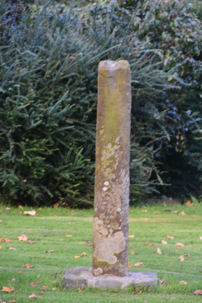
Boar Stone (Drem) submitted by Anne T on 9th Oct 2017. Using the zoom lens on my camera to get a better view of the southern face of this broken, relocated cross shaft.
(View photo, vote or add a comment)
Log Text: The Boar Stone, East of Drem Village: This stone is located to the north side of the B1377, in the garden of Prora Farm, some 1.4 km east of Drem station. It has been relocated from the edge of a field at NT 5280 7924, some 640 metres south south east of its current location.
The right to roam in Scotland does not cover people’s gardens, so I had to be content with walking up and down the width of the garden alongside the B1377, which was very busy, and has the train line running immediately to the south, so not the best spot.
There is no real information on Canmore, apart from the describe it as a cross. There is a link through to the East Lothian Council records, which describes this as “a broken sandstone cross-shaft with chamfered edges, 5ft 11ins high, 1ft 2ins broad and 11 1/2ins thick at the lower end, but tapering to 7 1/4ins in thickness at the upper end”, which comes from the name book of 1853.
Kirklandhill
Trip No.52 Entry No.3 Date Added: 10th Oct 2017
Site Type: Standing Stone (Menhir)
Country: Scotland (East Lothian)
Visited: Saw from a distance on 27th Sep 2017. My rating: Condition 3 Ambience 3 Access 5
Kirklandhill submitted by minteddy on 14th Dec 2006. Kirkland hill: Standing stone in cultivated field on north side of A1 and east side of road to North Berwick. I think it is taller but thinner than the Pencraig Hill standing stone. I always think it looks rather forlorn standing in this field.
(View photo, vote or add a comment)
Log Text: Kirklandhill Standing Stone, East Lothian: From Pencraig Hill Standing Stone, we drove 3.6 kilometres east along the A199 (which runs parallel to the A1) turning left (north) up the A198. The Kirklandhill Standing Stone is in the middle of the field immediately to the right hand side of the A198.
Whilst the Pencraig Hill Stone was in a field of mature cabbages, this field was planted in well established brussel sprout plants, with no room between them, so we could only view it from the road. We tried looking for a gate into the field off the A198 and the A199, but the entrance must be near to the Kirklandhill Farm building.
I had to content myself with photographing this stone from the edge of the field next to the A198, which was very busy with traffic. Next stop on the list were some standing stones near Traprain Law hillfort.
Standingstone (East Lothian)
Trip No.52 Entry No.5 Date Added: 10th Oct 2017
Site Type: Standing Stone (Menhir)
Country: Scotland (East Lothian)
Visited: Yes on 27th Sep 2017. My rating: Condition 3 Ambience 4 Access 5
Standingstone (East Lothian) submitted by cosmic on 31st May 2008.
Viewed from South
(View photo, vote or add a comment)
Log Text: Standingstone Standing Stone, East Lothian: As we pulled up outside the Standingstone farm house, a lady and her black pug came out of the farmyard. I apologised for turning up out of the blue, but did she know about the standing stone, and she said ‘yes’, asked if I knew where it was, and walked us to it. It was in a little orchard, behind the adjacent cottage. There were glacial striations on the stone, now vertical as the stone had been stood upright.
When talking about the hillfort above us (Tarprain Law) she said “the chieftain was supposed to have thrown his daughter off the top, for falling in love with someone she shouldn’t have. She was supposed to have turned into a robin. The strange thing about here is that we have hundreds and hundreds of robins, and they are here all year. Weird.” She gave a shiver. She told me we were supposed to hug the standing stones.
Loth Stone
Trip No.52 Entry No.6 Date Added: 10th Oct 2017
Site Type: Standing Stone (Menhir)
Country: Scotland (East Lothian)
Visited: Yes on 27th Sep 2017. My rating: Condition 3 Ambience 4 Access 4
Loth Stone submitted by minteddy on 14th Dec 2006. Cairndinnis Farm: Loth Stone. The stone is on the edge of a bridleway on south south west side of Traprain Law. The photograph was taken in autumn 1991. I had the impression from somewhere that the current position of the stone is not original. Has it been moved? I assume Loth must have been some chieftain or king after which the Lothian counties are named.
(View photo, vote or add a comment)
Log Text: The Loth Stone, west of Traprain Law hillfort: Just up the hill from Standingstone Farm, up a lovely grassy lane just to the west of Traprain Law hillfort. The stone has now been moved against a hedge. There is a small gate into the field, where the wheat had just been harvested, letting us walk right up to the stone and photograph it.
We did peer around the field hoping to see some sign of the cairn at NT 5781 7409, some 53 metres to the south of its current location but could see nothing.
With Traprain Law hillfort rising up to the east, this was a quiet, pleasant and atmospheric spot, although the standing stone did seem a little abandoned. Next stop was to be a hill fort in an even more remote location.
White Castle Fort
Trip No.52 Entry No.7 Date Added: 10th Oct 2017
Site Type: Hillfort
Country: Scotland (East Lothian)
Visited: Yes on 27th Sep 2017. My rating: Condition 3 Ambience 4 Access 5
White Castle Fort submitted by cosmic on 30th May 2008. Site in West Lothian:
Janet in first ditch
(View photo, vote or add a comment)
Log Text: White Castle Hillfort, East Lothian: This is in a wild and lonely spot. As we approached the hillfort, the mist started to roll in over the Thorter Burn Valley, the wind got up and whipped spots of rain across our faces.
I was amazed to be able to park right by the gate, where there were interpretation boards. Mind you, someone had left a pile of rubbish just inside the gate, which was horrible.
The ramparts to the south/west side of the fort are so crisp and clear, they could have been dug yesterday. The views down Thorter Burn valley were great, and to some extent the fort was protected by the hillside to the south.
We did see some evidence of disturbance on the top of the hillfort, together with what looked like an not-very defined house/structure to the northern side of the oval top of the fort. After being almost blown off the top of the hill, we decided on one last stop before heading back to Armadale for the night.
The Chesters
Trip No.52 Entry No.8 Date Added: 10th Oct 2017
Site Type: Hillfort
Country: Scotland (East Lothian)
Visited: Yes on 27th Sep 2017. My rating: Condition 3 Ambience 4 Access 4

The Chesters submitted by uisdean on 1st May 2008. Southerly ramparts of The Chesters. The hill overlooking the fort can be seen rising to the left of the picture.
(View photo, vote or add a comment)
Log Text: The Chesters Hillfort, East Lothian: Most places we drove past today had signposts to The Chesters, so reluctant to go back to the house before dark, we decided to stop off and look at this hillfort, which I thought must have been visited by many other Portal users/members, but only uisdean has submitted photographs – I was very surprised.
There is a small car park near Dalvreck Farm House, with a signposted walk through (at this time of the evening) a dark wood. This opens out into a meadow, which has tall wire fences all around it, “to prevent rabbit damage”, and to my horror, a very tall stile leading over another fence into the fort itself.
Actually, this stile was one of the easiest I’ve ever used to get over, as it had supports at the top to let me stand upright and feel balanced and secure, before clambering down the other side.
This is certainly a complex site. I was fascinated by a large boulder to the east of the site, and there is also an unknown part of the meadow to the north.
We tramped around, enjoying the quiet and the complexity of the site, until dusk fell really heavily and we decided it was time to go back and have something to eat.
Whiteadder Reservoir
Trip No.105 Entry No.2 Date Added: 4th Nov 2018
Site Type: Cairn
Country: Scotland (East Lothian)
Visited: Yes on 27th Oct 2018. My rating: Condition 2 Ambience 4 Access 4

Whiteadder Reservoir submitted by Anne T on 4th Nov 2018. This appears to be all that is left of the stone setting and cairn, although the grass and bracken were mid-calf height, so other stones could have been hidden underneath. The cairn is easily identifiable, as it stands above the surrounding ground level, with a stone emerging from one side of the centre of the mound. This view is looking west north west over the cairn.
(View photo, vote or add a comment)
Log Text: Whiteadder Reservoir cairn and stone setting: We parked at NT 64304 64291 and walked along the first part of the Herring Road onto the land high above Whiteadder Reservoir with the GPS to find this stone setting and enclosure, with the cold winds whipping around our ears. From what I'd read on Canmore, I expected something a little different from what we found on the ground, which was in effect a cairn.
Despite walking round the area looking for these stones, and trying to feel for stones under our feet, we only found what looked like a cairn with one stone sticking up out of it. It is the same area as that given by Canmore. A 1971 entry says the enclosure has been completely destroyed, except "three small stones exist." As the grass and heather was calf deep, it was probable the stones were hidden underneath.
Looking at the map on the Canmore record, the cairn we spotted is in the correct location for the stones, with the enclosure about 20m to the south, identifiable as there is a flat, circular area in the bracken. Beautiful views over the reservoir.
The sign on the ‘public path’ signpost reads: Heritage Path, Herring Road. This old path is named because it was used by the fishwives of Dunbar when carrying massive creels of herring to market in Lauder. This track was one of many different routes that were used by the fishwives over the centuries as paths became eroded and were replaced.” And “Herring Road to Dunbar, 12.5miles via Dunbar Common and Halls”.
Mayshiel Stone Circle
Trip No.105 Entry No.4 Date Added: 4th Nov 2018
Site Type: Stone Circle
Country: Scotland (East Lothian)
Visited: Yes on 27th Oct 2018. My rating: Condition 3 Ambience 4 Access 4
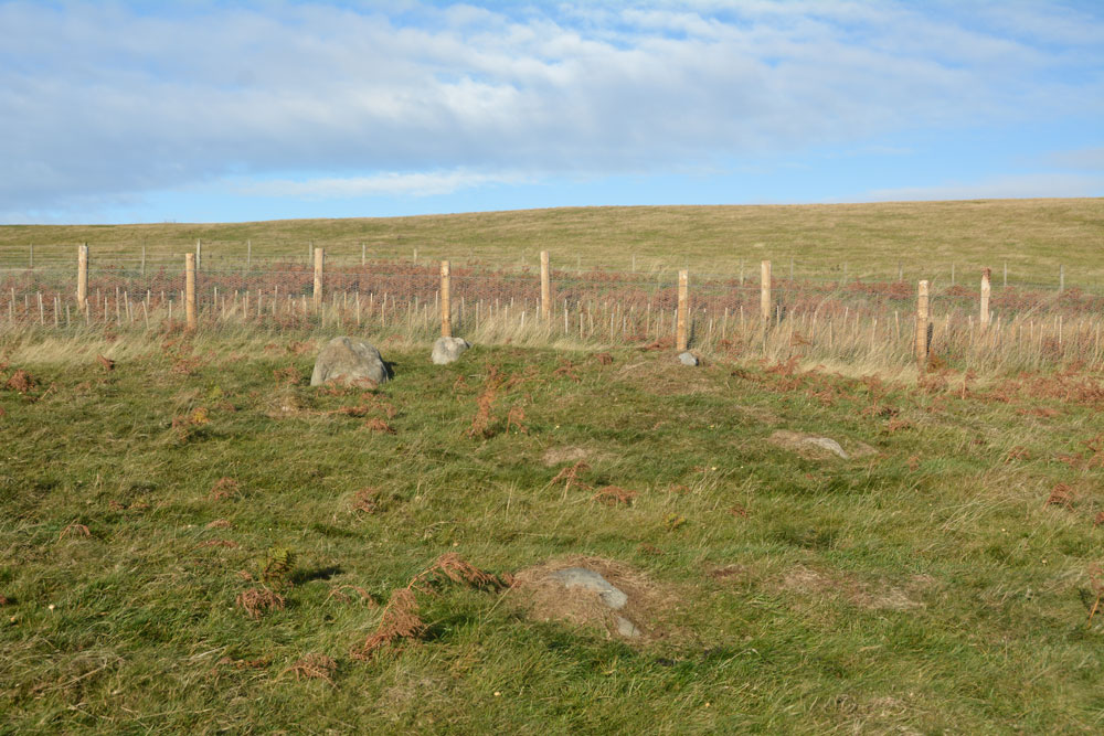
Mayshiel Stone Circle submitted by Anne T on 4th Nov 2018. The Mayshiel stones from the south. At the top of the slope, there were five stones which protruded out of the grass. Looking more closely, there were some further down-slope, largely hidden by turf, but nevertheless still part of this stone setting.
(View photo, vote or add a comment)
Log Text: Mayshiel Stone Setting: Whilst we were here to see the stones at NT 6298 6465, the first thing I spotted was a huge pile of clearance stones just up the hill in a field just north of the B6355. The second was what looked like a standing stone at the edge of the field at NT 62924 64612. On closer look, this may have been a large field clearance stone, which sits on top of other small boulders.
The stones at Mayshiel are very close to the road. At first glance, there are only three, but the longer we looked, more became evident.
There were also another group of stones at approx. NT 62814 64541 which had the appearance of a cist, but the stones forming the longer sides were very large. These stones may have just been a natural outcrop. One of the stones had been broken and the split off bit was lying half way along the northern end of the group.
Looking at the latter group of stones at home, they were similar in description to Canmore’s description of the Packman’s Grave (above).
At first glance, an insignificant site, but the more we walked round, the better it became, and it was well worth stopping off to look at this.
Rood Well
Trip No.105 Entry No.5 Date Added: 5th Nov 2018
Site Type: Holy Well or Sacred Spring
Country: Scotland (East Lothian)
Visited: Yes on 27th Oct 2018. My rating: Condition 4 Ambience 4 Access 5
Rood Well submitted by KiwiBetsy on 2nd Oct 2006. The Rood Well, also known as The Well of the Holy Rood or the 'Cardinal’s Hat', sits beside the B6370. It is located in a small garden area on the northeastern edge of Stenton, on the left if you are heading for Dunbar.
(View photo, vote or add a comment)
Log Text: Rood Well, Stenton: A very pretty well, and very easy to find. Just by the side of the road, some 300 metres north east along the B6370 from The Tron. The well is below pavement level, with steps leading down to it. The well cavity was damp but there was no pool of water. I couldn’t see any pipe leading into the well chamber, so assume the water must seep up into the cavity. Being closely surrounded by a stone wall on three sides, with a ploughed field beyond, it was a little tricky to photograph.
As the Canmore entry from the Old Church (ID 57841) says, the finial on the well is thought to come from the Old Church (14th century). There is a small plaque on the side of the well which reads: “16th century historic building”.
Witches' Stone (Spott)
Trip No.105 Entry No.6 Date Added: 5th Nov 2018
Site Type: Holy Well or Sacred Spring
Country: Scotland (East Lothian)
Visited: Yes on 27th Oct 2018. My rating: Condition 3 Ambience 3 Access 5
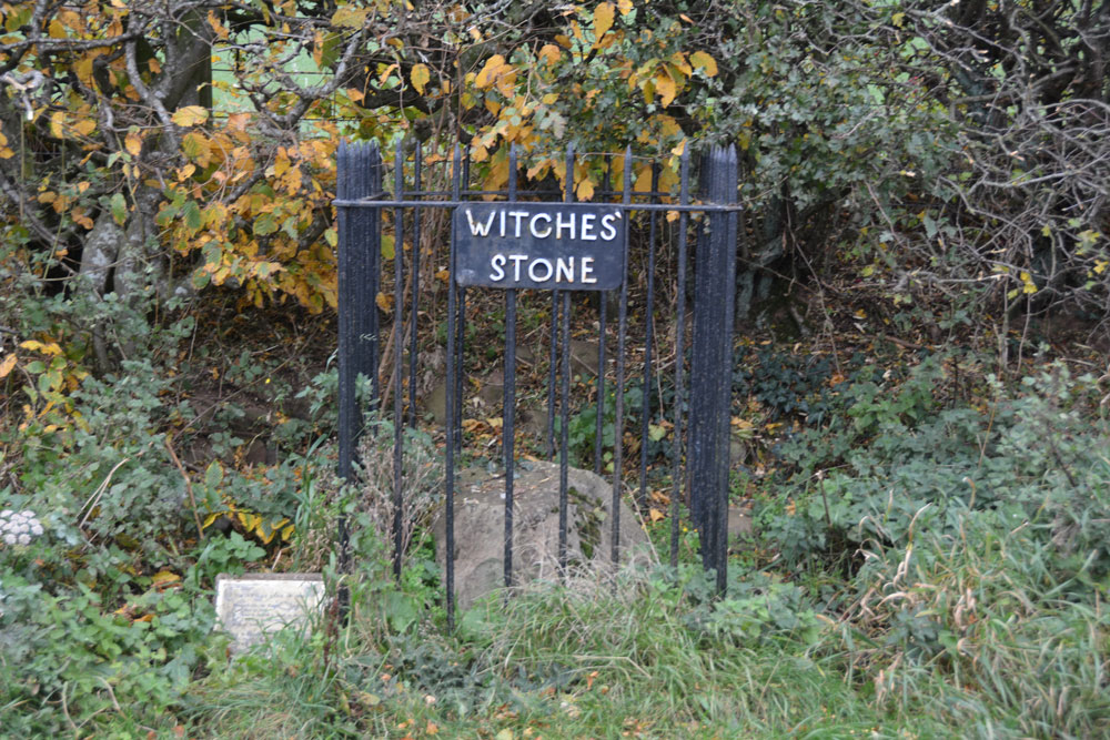
Witches' Stone (Spott) submitted by Anne T on 5th Nov 2018. This unprepossessing stone sits beneath a hedgerow, with a name sign and a small (now almost illegible information sign).
(View photo, vote or add a comment)
Log Text: The Witches' Stone, Spott: I had expected something a little grander than a large stone by the side of a hedgerow with a rusting iron railing and a sign that we could hardly read. There is a photograph on the Canmore record with a photograph of the sign from 2010 which is legible: “The Witches Stone of Spott. Marion Lillie, the Ringwoody Witch was burnt here in 1698. The stone is reputed to stand on the site of the burning of the last witch in the South of Scotland. Near to this site the Birley Tree stood, under whose branches the local Birley Court was held.”
I had to chuckle as whilst I was photographing a stone, another couple had stopped to take photographs of a brown sheep in a nearby field. Having taken quite a few photos, they continued their walk, walking right by this stone. Perhaps they’d seen it before. I found it touching that people still left coins here as offerings.
St John's Well (Spott)
Trip No.105 Entry No.7 Date Added: 5th Nov 2018
Site Type: Holy Well or Sacred Spring
Country: Scotland (East Lothian)
Visited: Yes on 27th Oct 2018. My rating: Condition 3 Ambience 3 Access 4
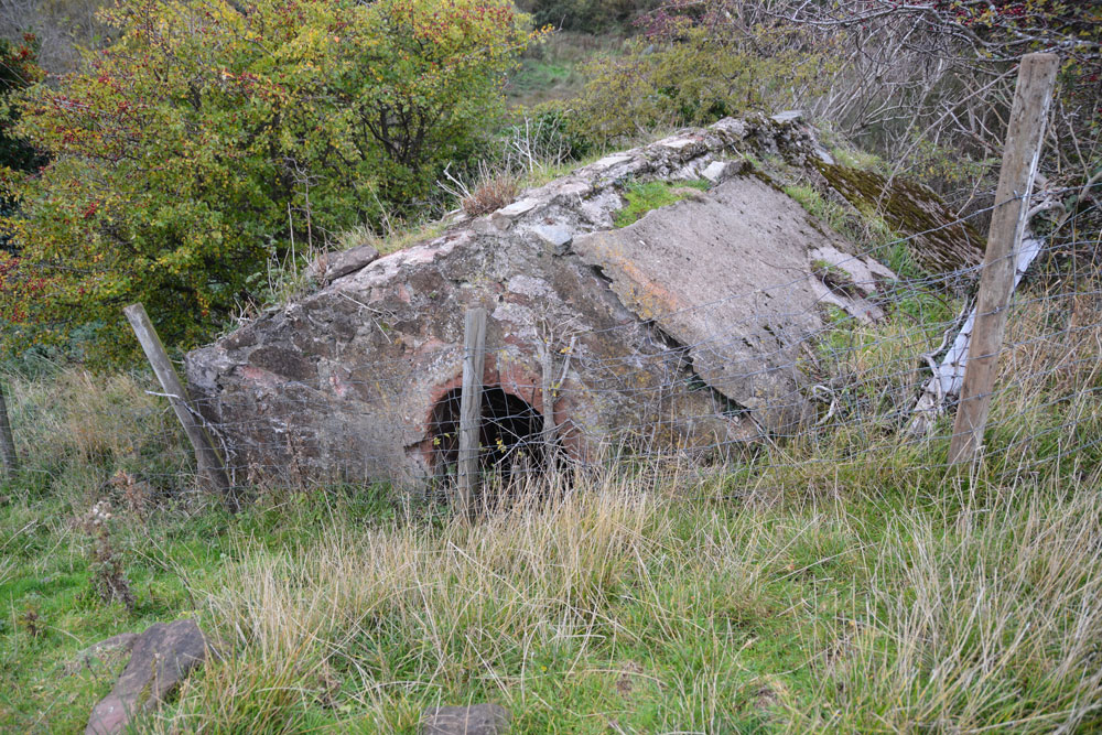
St John's Well (Spott) submitted by Anne T on 5th Nov 2018. This old cistern is some 100m further north, at the eastern side of the gully running from the well. I wondered if it was part of the 18th century works which piped water from this well into Dunbar.
(View photo, vote or add a comment)
Log Text: St John's Well, Spott: With the wind still whistling and starting to get dark, we really wanted to see this well and the nearby Easter Broomhouse standing stone before calling it a day. At the north eastern end of Spott, a gated stile by the small school lets you into the field, which, at the time of our visit, was full of very large, curious sheep.
Following the line of the first two telegraph poles, a gully comes into view. The well house is located at the top of this, at the bottom of the gully, so we needed to slither down the 6ft or so to the bottom to photograph the well.
Whilst the well cavity was dry, there was a pool of water a couple of metres further down the gulley.
Further down the field there was a very old, ruined building with an arched window. I am curious to know what this is – need to look it up on Canmore. Because of its location, my immediate thought was that it was a hermitage. No separate Canmore record, but is recorded on the map as a cistern.
Easter Broomhouse
Trip No.105 Entry No.8 Date Added: 5th Nov 2018
Site Type: Standing Stone (Menhir)
Country: Scotland (East Lothian)
Visited: Yes on 27th Oct 2018. My rating: Condition 3 Ambience 4 Access 4
Easter Broomhouse submitted by cosmic on 1st Jun 2008. Site in East Lothian:
Viewed from SE
(View photo, vote or add a comment)
Log Text: Easter Broomhouse Standing Stone: Dusk was falling as we arrived at this site, which I've long wanted to see. We parked by the water treatment works over the road at NT 67718 76493 and walked down the side of the ploughed area of the field until we were level with the stone, then ‘waded’ through the loose, ploughed soil until we reached the stone itself.
A lonely spot, although it has great views to the Firth of Forth and Bass Rock in the distance, to the north. It is a tall, sandstone pillar standing in an ocean of brown-red soil.
There are indeed 3 cups marks on its western face, along with some modern graffiti. The base of the stone has really been worn away; as the Canmore record says, this is the result of a steam plough cable.
