Contributory members are able to log private notes and comments about each site
Sites Anne T has logged. View this log as a table or view the most recent logs from everyone
The Ruthwell Cross
Date Added: 13th Oct 2014
Site Type: Ancient Cross
Country: Scotland (Dumfries and Galloway)
Visited: Yes on 12th Oct 2014. My rating: Condition 4 Ambience 4 Access 5
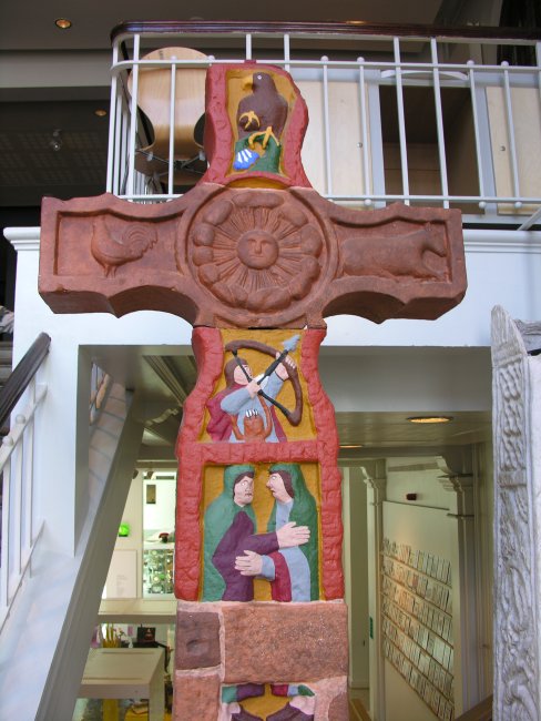
The Ruthwell Cross submitted by TimPrevett on 29th Jul 2007. A painted caster plast replica of the Ruthwell Cross in Manchester Museum, situated from the ground to first floor staircase.
(View photo, vote or add a comment)
Log Text: The Ruthwell Cross, Ruthwell: I’ve visited the Savings Bank Museum in Ruthwell to have meetings with the curator on more than one occasion and thought I had visited the Ruthwell Cross before (both my husband and I have vivid memories of taking the children to see an ancient sandstone cross in a churchyard when we first moved to Dumfries and Galloway in 1992, and while we both thought it was this one, it’s not – a mystery!).
There is a large visitors’ car park to the west end of the church. A key is available from the manse cottage, in a little stand outside with a blue label saying ‘church key’ and a small box with a lift up lid.
I was surprised by the sheer size of the cross, which absolutely dominates the church. Andrew clambered down into the pit and took some photographs looking up the whole of the cross, which was quite difficult to photograph given the sky lights overhead – we needed a dull day to avoid the light spilling in.
This is the second cross with runes on we’ve seen in three days (the other at Bewcastle), although the Ruthwell guide goes to great lengths to point out they are a true preaching cross, not a memorial!
Some of the elements at the top of the cross don’t quite seem to fit – they are much darker sandstone than the rest, but have probably not been weathered so much.
I was staggered by the price of a guide book (£5). There was a constant stream of visitors, coming in ones and twos – one family leaving as we arrived and another we handed the key to as we left.
The Shearers
Date Added: 8th May 2015
Site Type: Stone Row / Alignment
Country: Scotland (Scottish Borders)
Visited: Yes on 4th May 2015. My rating: Condition 3 Ambience 4 Access 3
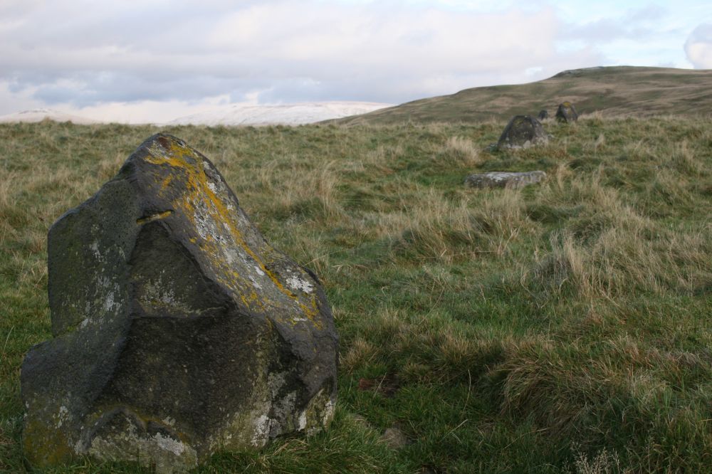
The Shearers submitted by minteddy on 18th May 2009. NT79101925. The Shearers. This view is looking east. Cheviot is the snow covered hill in the background. This photo was taken at the end of October 2008. The area is full of ancient remains, Roman roads and camps.
Five Stanes stone circle and Trestle cairn, the Roman Road of Dere Street are barely 5 km to the west. The path way up to the Shearers follows the line of the ancient track way "The Street" through the Cheviot Hills. It is truly a magical area. I love it.
(View photo, vote or add a comment)
Log Text: The Shearers Stone Row, near Hownam, Scottish Borders: Continuing on from the Horseshoe Wood Standing Stone, continuing up the hill, towards the top of the hill, but not quite, the pathway divides. To the left runs a path to Belford, with The Street leading to Alwinton.
Turning left towards The Shearers and Hownam Rings Hill Fort, we needed to go through two gates and track across the field rather than follow the signposted path. We noticed (more on the return journey due to the evening light) an earthwork. It was particularly evident near the two gateways by the signpost. According to the Canmore/RCAHMS record (341447) it is an earthwork of uncertain date, but very like the medieval estate boundaries we’ve been looking with the local archaeology group at Davy’s Lee in Northumberland.
There is no formal track across the tussocky grass, so the walking was a little trickier, but not impossible - there are plenty of sheep tracks to avoid turning your ankles. I saw at least three pairs of boulders in the grass leading from the Street to the Shearers – could these possibly be signposts to this monument, such as at the Loupin’ Stanes and the Girdle Stanes?
Standing in the middle of The Shearers it felt like being in the middle of a shallow bowl with a view only to the west. Following the row to its western end, it appeared to end in a boggy area – was this deliberate?
Hownam Rings Hill Fort was only 100 metres to the north and clearly visible above the Shearers.
The Shearers
Trip No.79 Entry No.2 Date Added: 2nd Jul 2018
Site Type: Stone Row / Alignment
Country: Scotland (Scottish Borders)
Visited: Yes on 27th Jun 2018. My rating: Condition 3 Ambience 4 Access 3
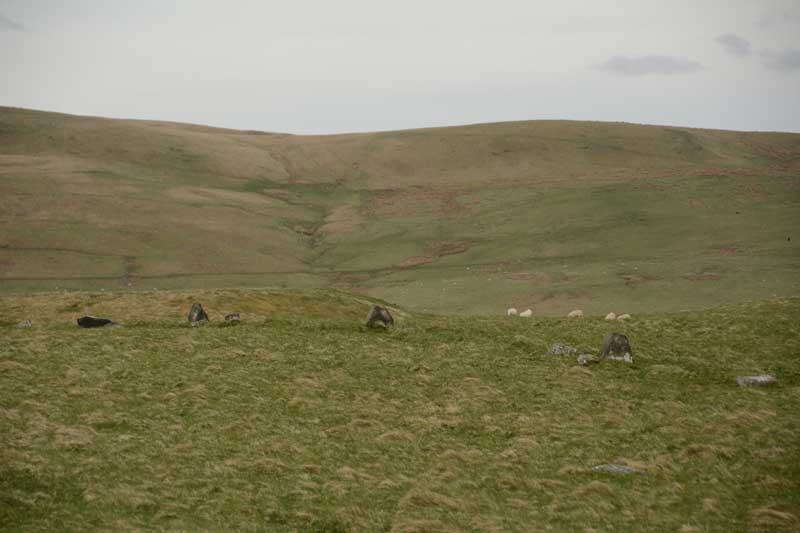
The Shearers submitted by Anne T on 8th May 2015. This was my first view of The Shearers, running across the centre/middle of the photograph from left to right.
(View photo, vote or add a comment)
Log Text: The Shearers, Hownam, Scottish Borders: By the time we got to the Shearers, the sun was high in the sky and beating down on us. Many horseflies, but thankfully no ticks. I was able to help with Sandy G's survey by acting as ‘the target’ for the disto (holding a piece of paper upright against the ranging pole so they could get accurate distances from the pole to each stone).
It occurred to me that where the row goes down the slope and ends at what is now a bog, at NT 7907 1927, perhaps this might have been a spring in ‘the olden days’ and been the water source for the hillfort.
The top end of the row seems to ‘bend’ slightly to the south east, heading towards looks like a hollowed out/partially excavated cairn.
It was fascinating to watch Sandy’s process of surveying the row, the row being too long to survey in one, so it was done in two halves. First he measured the distance of the centre of each stone from a ranging pole located in one spot, then took the angle of the stone from its central point to the ranging pole, transferring the measurements onto a plan, then photographed each stone individually. Finally, he walked up and down looking for ‘sighting lines’ – seeing what was visible from each stone, in which direction, and whether or not the stones echoed the shapes of any features in the landscape.
The conclusion Sandy came to (I think, as he says working out the details later will confirm or not) is that he counts this as a ‘possible’ stone row. It appears to be clearly associated with the nearby hill fort. I still dispute Canmore’s interpretation as the remains of a field boundary, as surely it would be connected to other old field boundaries nearby. None of these other boundary features had the earth removed from them.
We finally got back to the car at 6.30pm - the time had just flown. A very educational afternoon, and I was really pleased to have been involved in Sandy's survey. Pleasant day in pleasant company.
The Sill
Trip No.140 Entry No.3 Date Added: 25th Jun 2019
Site Type: Museum
Country: England (Northumberland)
Visited: Yes on 23rd Jun 2019. My rating: Condition 4 Ambience 3 Access 5

The Sill submitted by Anne T on 25th Jun 2019. The Sill building, as seen from its north eastern corner. It is located in Once Brewed, immediately next to the B6318 (Old Military Road).
(View photo, vote or add a comment)
Log Text: The Sill, Once Brewed: After visiting Great Chesters/Aesica, we popped over to the Sill for a cup of tea and a bowl of soup. It took three attempts to get our (simple) order correct, although as the Sill was popular with walkers, it meant queuing up each time to get the correct items.
I was curious to see if Tynedale North of the Wall Archaeology Group had their display about their surveys at Edges Green and Cleughfoot. We walked round the very small exhibition, which included a piece of rock art (on loan from the Great North Museum) and an inscribed Roman stone, but could see nothing from the group.
It was difficult to know if the display was aimed at adults or children; having wandered around it, most of it seemed aimed at the younger age group.
A pleasant place for a rest and refreshments, but I had expected more of a museum.
The Sleepy Sheep, Deepdale
Date Added: 3rd Jun 2015
Site Type: Natural Stone / Erratic / Other Natural Feature
Country: England (County Durham)
Visited: Yes on 2nd Jun 2015. My rating: Condition 4 Ambience 4 Access 4
The Sleepy Sheep, Deepdale submitted by durhamnature on 28th Jun 2012. The Sleepy Sheep, a pink granite glacial erratic beside the River Tees.
(View photo, vote or add a comment)
Log Text: The Sleepy Sheep Stone, Natural Erratic near Barnard Castle: Having decided to go to see Egglestone Abbey, I did a quick trawl on the Portal to see what else was nearby around Barnard Castle. The Red Well and this stone looked intriguing so I printed off the pages, and off we set. [Thanks to Durham Nature for this entry – I’ve since looked up his web site and will dip into this again.]
On the way back from Egglestone Abbey, instead of turning right along The Sills to go over the road bridge over the Tees into Barnard Castle by the castle, we went straight on along Lartington Lane. Whilst it’s a relatively minor road, it is wide but busy along its first part, with Hensall Way peeling off and leading up to HM Young Offenders Institute Deerbolt. Not sure which side of the river the stone was on, we parked on a wider section of the road near Deepdale Cottage, just along from the junction with Henshall Way. We walked back along the narrow pavement to Deepdale footbridge over the river to its northern banks, but drew a blank. From the image from the Portal, the stone was most likely to be on the southern side of the river, so we trekked back over the footbridge (distressingly the wooden sheets across the bridge were all rotten and cracking, and plastic reinforcement had been laid across some parts).
Finding the entrance to the park on the southern banks of the Tees between two cottages, we opened (and closed) the gate and followed the metalled road along the grassy meadow. In a couple of hundred yards I said to Andrew, “either that’s a sheep that’s keeping very still, or it’s the stone.” It was the stone.
The shape of this natural erratic is indeed like a sleeping sheep. Made definitely of red Shap granite, it was so cute! We wondered how on earth it had got there. The Durham Nature web site tells us that there are a number of these erratic in the area, pushed over the Pennines by a glacier during the last ice age. I definitely want to go and find the others at Deepdale and The Mortham Stones.
The location is also very pretty, sleeping between the small road and the river with lush, green grass blowing in the breeze and sheep with their photogenic lambs standing watching what we were doing.
The winds were definitely getting stronger by this time (pity my friends walking from John O’Groats to Lands End who are up around Shap today!) so set off to find The Red Well, then onto Staindrop to find the Anglo Saxon Stone Fragment on the way back.
The Yarrow Stone
Date Added: 29th Jun 2015
Site Type: Standing Stone (Menhir)
Country: Scotland (Scottish Borders)
Visited: Yes on 27th Jun 2015. My rating: Condition 3 Ambience 4 Access 4
The Yarrow Stone submitted by mafenty on 28th Mar 2007. The Yarrow Stone
(View photo, vote or add a comment)
Log Text: The Yarrow Stone, Yarrow, Scottish Borders: From Selkirk, we took the A708 towards St Mary’s Loch and Moffat. There was a diversion coming out of Selkirk, due to roadworks, so we had to double back to get onto the A708. Passing through the hamlet of Yarrowford, the road runs by Yarrow Water to the left hand side – a very pleasant, fertile valley. Reaching Yarrow, the kirk was signposted to the right hand side of the road, and a small grass-crete area in the centre of a triangle of roads made it possible to stop and get our bearings. Continuing westwards along the A708, we kept our eyes peeled for standing stones which, according to the Canmore notes, were visible from the road, but didn’t see anything. We reached the hamlet of Yarrow Feus before turning back and retracing our steps towards Yarrow.
We found the signpost for Whitefield (a farm) easily enough on the left hand side of the road, and there was a small layby big enough for two cars to park by the side of the A708. From here, a track led up to a gate into a field, where the Yarrow Stone was visible surrounded by a wooden fence to protect it from stock (there were none in the field at the time of our visit). The grid reference was spot on (thank you!) and it was an easy, short walk up the stony track.
There is a small plaque which reads: “The Yarrow Stone. This inscribed stone records the grave of two Christian British princes who lived during the 5th or 6th century AD. It was uncovered around 1803, when up to twenty large stone cairns were removed from a former moor, known as Annan Street, to create arable fields. The inscription is in Latin and can be read as: (+) HIC MEMORIA PE(RP)ETV(A) {I}N LOCO INSIGNISIMI PRINCI PES NVDI DVMNOGENI HIC IACENT IN TVMVLO DVO FILI LIBARALI{S} which translated means “this is the everlasting memorial. In this place lie the most famous princes Nudoss and Dumnogenos. In this tomb lie the two sons of Liberalis.” After the end of Roman Britain, in the 5th century AD, much of the Southern Uplands became part of the British Kingdom of Strathclyde. St. Ninian was the force behind Christian Missionary work in the region, which sought to convert the population through its leaders. This site may already have been a place of ceremonial importance in prehistoric times, but the Yarrow Stone and other burials in stone lined graves (cists) suggest that it was also valued by early Christians.”
From here it was a short hop to find the Warrior’s Rest standing stone.
Thimbleby Nine Stones
Trip No.2 Entry No.1 Date Added: 9th Oct 2019
Site Type: Standing Stones
Country: England (Yorkshire (North))
Visited: Yes on 9th Jun 2016. My rating: Condition 3 Ambience 4 Access 3
Thimbleby Nine Stones submitted by SolarMegalith on 15th Mar 2013. Northern pair of standing stones - view from the south (photo taken on March 2013).
(View photo, vote or add a comment)
Log Text: Nine Stones Stone Row, near Osmotherley, North Yorkshire: Having added a few of the Stone Rows of Great Britain sites on the Portal, and needing to go down to Thirsk it was too much of a temptation to resist visiting one or two of the North Yorkshire sites. With only a 3 hour window before having to travel onto Doncaster, the only one we could reach and explore in time was Nine Stones, just outside Osmotherley.
We’ve been to this area before to look at Anglo Saxon crosses in churches and ended up getting hopelessly lost, but this time we had the OS map and our GPS. With the sun shining down from an almost cloudless sky, we reached the car park at Square Corner easily enough. It never ceases to amaze me that there are so many more people in this part of the world than in Northumberland. There were people picnicking on the side of the road near Solomon's Temple enjoying a wonderful view over Oak Dale valley and the woods of Crabtree Bank and Thimbleby Bank Plantations.
As we pulled up, a number of dog walkers drew up, chattering noisily, and I hoped they weren’t going to follow us and destroy the peace and quiet of the afternoon (I’m definitely getting to be a grumpy old woman!). Fortunately, they followed the Cleveland Way up the hill to the south.
From the car park, we walked the couple of hundred metres to the gate where the footpath west over Thimbleby Moor and the Cleveland Way southwards meet. The GPS told us there was almost 700 metres to walk to Nine Stones, so we set off over the stile over the wall by a second gate to the west. The first couple of hundred yards were easy walking along a stoned footpath leading off to some modern shooting butts to the west. After 200 metres we needed to veer off southwards to follow the dry stone wall westwards. This was all through knee deep heather with the occasional field drain and boggy patch thrown in. After another 200 yards we realised we’d reached a much quarried area; there were deep holes full of water which we could only see when we were almost upon them. I managed to disappear up to my ankles in one, although there were other that looked far deeper.
Whilst the area has many blocks of stone poking up through the heather, towards the top of the slope there suddenly appeared on the horizon two standing stones, looming large, beckoning the walker. Here was (were?) Nine Stones, at last.
This stone row was well worth the trudge through the undergrowth. At the northern tip of the row there are five stones, two tall, two stumpy and one almost buried in the heather. We wondered which were actually part of the stone row. The north-western most stone looked as if there had been an attempt to quarry the top of it in the distant past (comparing the holes to some at Edges Green, near Cawfields) that we’ve seen recently.
Two more tall stones sit close to the stone wall, and a few more stones appear further south in the forested area. The Stone Rows of Great Britain site tell us that this stone row is 60 metres long, but husband, tramping through the forest, thought it might be possible that the row was nearer to 100 metres (but then which are natural stones and which are recumbent standing stones?).
There are so many other features in this area to explore: Miley Pike Tumulus, Robinson’s Cross (remains of), a Holy Well, Faber’s Stone – well worth a repeat visit.
Thockrington Cross
Date Added: 28th Mar 2018
Site Type: Ancient Cross
Country: England (Northumberland)
Visited: Yes on 3rd Oct 2014. My rating: Condition 3 Ambience 4 Access 4

Thockrington Cross submitted by Anne T on 6th Oct 2014. Grade II listed fragment of Anglo Saxon cross sitting in its more modern plinth, 10 metres south of the porch of the church.
(View photo, vote or add a comment)
Log Text: Thockrington Cross, Northumberland:
Having emailed to thank the Reverend Michael Slade (Mike) for the information about Chollerton and Birtley, he replied to my email this morning, saying: Dear Anne, Thank you for your encouraging email. I am so glad you enjoyed your visit. Do have a look at one of my other churches, St Aidan's Thockrington. It is open during the day too and is in the most spectacular location. There is a Grade 2 listed Saxon Cross in the churchyard, at least what's left of the cross! Well worth a visit anyway. And there is St Christopher's Gunnerton, an Arts and Crafts church, kept locked but a key is available locally. Michael Slade, Vicar
So husband Andrew and I went along this afternoon. Thockrington is essentially a very large farm with a house or two attached. The roads, whilst only a couple of miles from the A68, are across bleak moorland.
There is parking (on grass at the side of the single track road) by the gate to the church, then a gate leads you up into a field to a gate to the churchyard. The wind was extremely strong.
I spotted the remains of a cross shaft – propped up in a modern plinth (it moved when touched). It is very weathered and the remains of carving (apparently an upside down figure) can be seen upon one side.
The inside of the church is strange. The nave is obviously Victorian, but the chancel seems to be the original, old church with very off-true pillars. Fascinating.
Thompson's Rock
Trip No.59 Entry No.2 Date Added: 19th Nov 2017
Site Type: Holed Stone
Country: England (Northumberland)
Visited: Yes on 12th Nov 2017. My rating: Condition 3 Ambience 4 Access 4
Thompson's Rock submitted by Bolddubhglas on 14th Jun 2008. Thompson's Rock Simonside Beacon
(View photo, vote or add a comment)
Log Text: Thompson's Rock, Simonside: This was the coldest, windiest day of the year so far,, and I thought we were going to a much more sheltered spot, so I wasn't dressed for the weather. Ashamed to say I sent husband off with the camera, as he was fully equipped for this moorland. He reported the rock was well worth going to see.
Thornborough Central
Date Added: 14th Jul 2014
Site Type: Henge
Country: England (Yorkshire (North))
Visited: Yes on 11th Jul 2014. My rating: Condition 3 Ambience 4 Access 4
Thornborough Central submitted by DavidRaven on 28th Nov 2003. Thornborough central, by the southern gap in the henge banks. November 2003.
(View photo, vote or add a comment)
Log Text: I was completely taken back by the sheer scale of Thornborough Henges. Wow. My husband had managed to get the afternoon off, so I picked him up at Thirsk, and we followed the A61 then the B6267 through Ainderby Quernhow, under the A1, until we got to Nosterfield - a distance of just over 9 miles. It didn't help that Thornborough Henges are one third on one Ordnance Survey map (302) and two thirds on another, which I didn't have with me. However .... Turning left at Nosterfield, we drove past the Northern Henge, but there was nowhere to park, so we decided to carry onto West Tanfield, where we turned left at the mini roundabout, then the next left, towards Thorborough. Back Lane, as I think this is called, goes right past the quarries and immediately to the southern end of Thornborough Central. We bumped up onto the grass verge about 100 yards away and walked back to the Henge. Up and over the very rickety style (one leg was at 45 degrees to vertical) and over into the field.
The scale of this henge was too big to take in - certainly almost too big for the camera. The outer banks of the henge are largely still in place, although it looks as though people have been digging on top of them, although with the rough grass in the middle of the banks, it wasn't possible to see any of the internal ditches.
After having walked all around the banks, we tried to walk down the side of the farm to the northern edge of the henge, which we thought was a bridlepath coming down from Moor Road, close to the Northern Henge, but the field was full of lively cattle, so we gave up and walked back to Back Lane.
There was a bridlepath heading off left about 50 yards up the road towards West Tanfield, so we decided to walk to the southern henge.
After the first 200 yards, the bridlepath went through a field of very ripe oil seed rape plants, and it was hard going getting through this.
We were almost at the place where we thought the southern henge was located when someone starting shooting very close to the bridlepath; they were shooting at birds, and one came down very near me. Whoever it was didn't respond to our (loud) voices asking if it was safe to continue, so sadly, we had to retreat.
We went back to the car and drove round to Thorborough North, where we found a place to bump up onto the side of the road, where we weren't blocking traffic down this relatively narrow lane.
Thornborough Central
Trip No.64 Entry No.3 Date Added: 16th Jan 2018
Site Type: Henge
Country: England (Yorkshire (North))
Visited: Yes on 15th Jan 2018. My rating: Condition 3 Ambience 4 Access 4
Thornborough Central submitted by DavidRaven on 28th Nov 2003. Thornborough central, by the southern gap in the henge banks. November 2003.
(View photo, vote or add a comment)
Log Text: Thornborough Henge: We stopped off here just before sunset and walked round the henge in the dusk. This time, rather than being here on our own, there were lots of dog walkers around for the first part of our visit. I was horrified by the amount of burrowing that was all around the henge; it seemed to be slowly destroying the banks of the henge. I don't remember there being this much on our last visit. Not sure what to do about it. An email to the local archaeologists?
I took some photographs but need to work out how to produce a panorama from them, as my photostitch software seems to have stopped working.
Thornborough High Barns
Date Added: 14th Mar 2015
Site Type: Rock Art
Country: England (Northumberland)
Visited: Yes on 8th Mar 2015. My rating: Condition 3 Ambience 3 Access 4
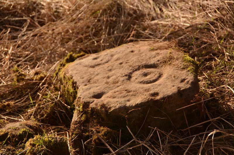
Thornborough High Barns submitted by Anne T on 12th Mar 2015. This single, displaced, stone shows two clear cup and ring motifs with other cup marks running around the cup and ring motif to its north-eastern corner.
(View photo, vote or add a comment)
Log Text: Thorborough High Barns Rock Art (single displaced stone): We first went to visit this site on 25th May 2014. Even though we were armed with a six figure grid reference number and detailed map, we were unable to locate this stone due to the high grass and deep brambles on both sides of the hedge. However, on this visit, the stone was clearly visible on the opposite side of the hedgerow/fence line from the footpath/bridleway. Close to the location of the stone there was a broken fence and a clear trackway which other walkers had used, so we nipped through very quickly to photograph this stone. Note to future visitors to this site: the hedge row has recently been planted, so access in future years will be difficult. I'm not sure who the landowner is, but will try and find out, and add a comment to this page. Further down the footpath, where it reaches a wood and stream, there is a gateway through to the field containing the stone, and it looks possible to walk back to the stone.
Thornborough N
Date Added: 14th Jul 2014
Site Type: Henge
Country: England (Yorkshire (North))
Visited: Yes on 14th Jul 2014. My rating: Condition 3 Ambience 4 Access 4
Thornborough N henge submitted by MarionBenham on 4th Nov 2003. N henge Thornborough, despite the trees its easy to see the form of the henge, this pic was taken looking South toward the central henge through the opening in the henge bank.SE281801
(View photo, vote or add a comment)
Log Text: After visiting Thorborough Central (and having tried to see where Thornborough South was), we went back to the Northern Henge. Having driven past the first time and failed to find somewhere to park, this time we spotted where other people had parked, complete with a gap in the trees to nip through.
The henge is completely covered in trees, although the outer banks, berm and inner ditch are visible, although not conducive to good photography. There is a footpath which leads all the way round the berm.
We managed to get to the southern entrance of the henge and looked out to central henge. I've submitted a photograph of the view from one henge to another on the 'Thornborough Central' page.
With the sun coming through the trees and no-one else around, this was a very atmospheric spot.
Three Boys
Trip No.135 Entry No.16 Date Added: 1st Aug 2019
Site Type: Standing Stone (Menhir)
Country: England (Devon)
Visited: Yes on 16th May 2019. My rating: Condition 3 Ambience 2 Access 3
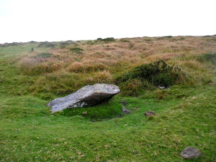
Three Boys submitted by thecaptain on 15th Oct 2004. Nearly 2 metres long, this fairly large, almost fallen stone was probably once a blocking stone at the southern end of Shovel Down row 6.
Viewed looking northwest with a row 6 stone under the gorsebush
(View photo, vote or add a comment)
Log Text: Three Boys: This was our last stop of the three days, and a lot of a let-down as someone had very recently used this stone as a toilet and left a great deal of white toilet paper around it. Yeuk! I think Gordon and/or Dave may have reported this to the authorities to clear up.
After this, we walked steadily back to the car park, took a few final photographs of the group altogether, using Janet and Gordon’s camera on my tripod on a timed setting. Then Andy, Dave, Andrew and myself headed back to Princetown to look inside the Visitor Centre.
Three Crosses Well (Boulby)
Trip No.159 Entry No.7 Date Added: 7th Mar 2020
Site Type: Holy Well or Sacred Spring
Country: England (Yorkshire (North))
Visited: Yes on 4th Mar 2020. My rating: Condition 3 Ambience 4 Access 4
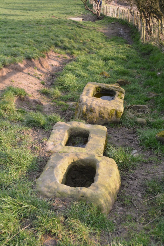
Three Crosses Well (Boulby) submitted by Anne T on 7th Mar 2020. The three cross bases, with the top of the well house just visible down slope.
(View photo, vote or add a comment)
Log Text: Three Crosses Well, Boulby: Parked outside the holiday cottages (there was a large layby just down the road). Originally followed the footpath sign, which took us down a steep bank, but Andrew found a farm track a little further along the south side of the A174, laid through a new area planted with saplings. Despite looking for someone to ask permission from at the farm and the holiday cottages, we were unable to find anyone, so were very carful to stick to the footpath/track.
At the end of this track, three cross bases came into view, and we peered over the fence line to see the well. The well house itself is a little down slope from the cross bases. We were curious as to the connection between the cross bases and the well.
The view of the sea from the cross bases is hidden by a natural small hill/mound. This is a magnificent site, despite the proximity to the potash mine.
Three Howes Rigg (East)
Trip No.15 Entry No.2 Date Added: 11th Apr 2017
Site Type: Round Barrow(s)
Country: England (Yorkshire (North))
Visited: Yes on 9th Apr 2017. My rating: Condition 3 Ambience 3 Access 5
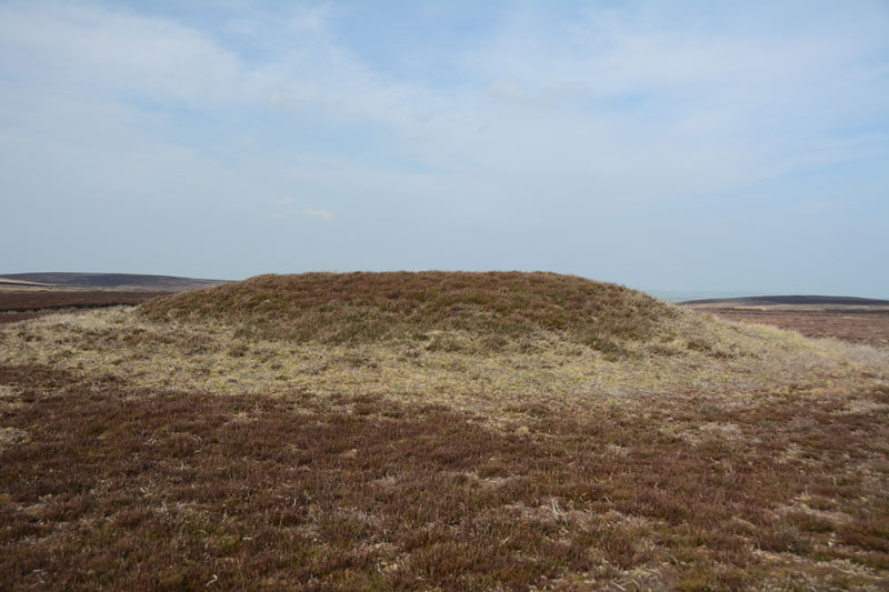
Three Howes Rigg (East) submitted by Anne T on 11th Apr 2017. The northern-most, most visible, of the three barrows on the eastern side of Smeathorns Road. As seen from the road.
(View photo, vote or add a comment)
Log Text: Three Howes Rigg (East), Smeathorns Road, North Yorkshire: Having stopped at White Cross and Three Howes Rigg (West) first, and having 'got our eye in', these barrows rise from the surrounding ground on access land. On the eastern side of Smeathorns Road, and clearly visible on UK Grid Finder, tramping across the heather moorland was easy on the feet.
Now largely used to feed the grouse (full feeding dishes on the tops of these barrows), they diminish in height from the north to the south. There is a fourth mound to the east of the middle barrow, but this looks more like a farmer's spoil heap rather than a barrow, and I couldn't find any reference to it on Pastscape or Historic England.
Looking at the map, there are so many barrows, crosses and other features around here, I'd like to spend more time in this area.
Three Howes Rigg (West)
Trip No.15 Entry No.2 Date Added: 11th Apr 2017
Site Type: Round Barrow(s)
Country: England (Yorkshire (North))
Visited: Yes on 9th Apr 2017. My rating: Condition 2 Ambience 3 Access 5
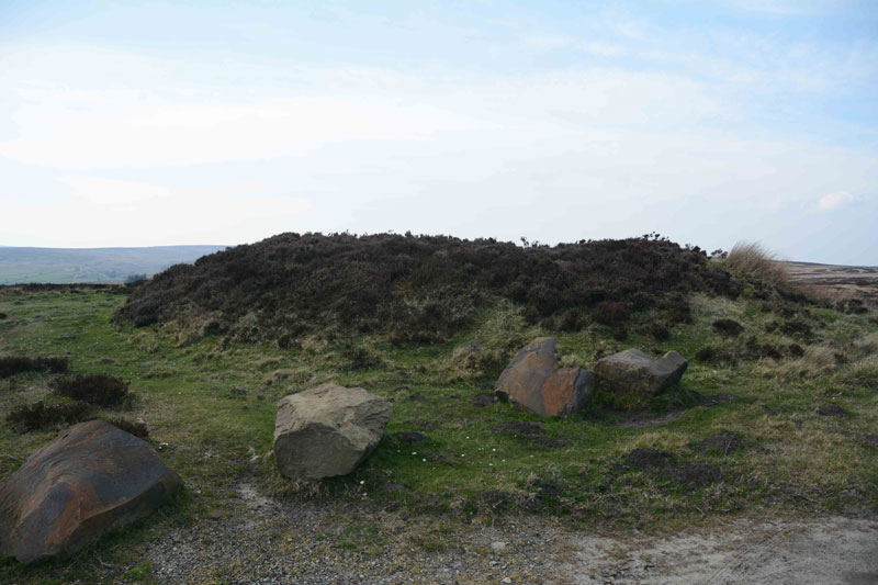
Three Howes Rigg (West) submitted by Anne T on 11th Apr 2017. The larger of the two round barrows on the western side of the road at Three Howes Rigg. The larger boulders presumably stop people from parking and destroying the site, although it creates a handy layby to stop and enjoy all five of the barrows at this location (bar the traffic speeding by!). Sited at NZ 68106 10279.
(View photo, vote or add a comment)
Log Text: Three Howes Rigg (West), Smeathorns Road, North Yorkshire: Despite being called ‘Three Howes’, there are actual 5 barrows in total! It would be easy to whizz by these barrows, as they appear as slight mounds at the top of the ridge. With cars speeding by at a good 60mph or so, it’s difficult to slow down and park, but there is a space between the two barrows on the western side of the road, flanked by large boulders to protect the fourth and fifth barrows.
Once identified, they are obvious in the landscape. Having first stopped at White Cross some 500 metres to the north, being on access land, we tramped over the heather and moorland to take a closer look.
We started with the two barrows to the west of the road and worked our way northwards. The northern-most has been cut slightly by the road to its eastern side; the southern-most was heavily covered in calf-high bracken. We missed the inscribed stone in the middle of this one, but the carving seems to be relatively modern, looking at the Historic England entry.
Three Kings
Trip No.122 Entry No.1 Date Added: 30th Mar 2019
Site Type: Stone Circle
Country: England (Northumberland)
Visited: Yes on 28th Mar 2019. My rating: Condition 3 Ambience 4 Access 3
Three Kings submitted by cosmic on 29th Aug 2004. Three Kings from East
(View photo, vote or add a comment)
Log Text: Three Kings Stone Circle, Byrness: Driving up the A68 from Corbridge, passing through Rochester, we turned left off the A68 at NT 78013 01533 into the Border Forest Caravan Park. We thought we’d get to a car park where we could leave the park, but instead ended up at a Reception hut with a barrier closing off the road. There was no one in the hut, so I rang the buzzer. Rather than explain what I wanted, a man’s voice came through the speaker “I’ll be with you in a moment”, and rang off. Seconds later a man on a bike appeared. I asked him if there was anywhere we could park to go and see the Three Kings, and he said “as we’d asked, we could park here” (by the hut), and he gave very precise directions for reaching the stone circle. He also told us that the Forestry Commission hadn’t been maintaining the track to the stone circle very well, and some of it was very overgrown.
Stopping to almost scratch the pet pig’s nose (he was called Bubbles (sadly not more 'Squeak')), we set off south west through the static caravan area, crossing over the metal bridge, then turned north west along part of the Pennine Way, walking over a wider bridge where two rivers meet, then turned almost due west along a forest track, which turned a corner southwards and climbed steadily uphill.
We missed the first track up to the stone circle, as it really was very overgrown, but continued up the hill and came to reasonably well defined track, over a boggy area, then uphill along a moss covered track which eventually came to some wooden steps, which even had a handrail in parts. From the comparative dark of the forest, we came out into a sunlit clearing with the four poster to our right hand side.
Thunder Stone (Castlehowe Scar)
Date Added: 9th Sep 2014
Site Type: Natural Stone / Erratic / Other Natural Feature
Country: England (Cumbria)
Visited: Yes on 7th Sep 2014. My rating: Condition 3 Ambience 3 Access 4
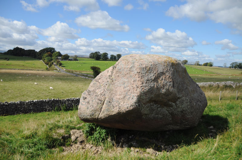
Thunder Stone (Castlehowe Scar) submitted by Anne T on 8th Sep 2014. Another face of this Thunder Stone. The red of the Shap Granite can be clearly seen in the strong sunlight.
(View photo, vote or add a comment)
Log Text: Thunder Stone (Castlehowe Scar), near Shap, Cumbria: When my husband suggested going back to Shap, I groaned inwardly - another day of walking round searching for stones within the village? But I was in for a great surprise. Andrew had identified stone circles and cairns within a few miles of each other, and we had a great afternoon.
On our way to Castlehowe Scar Stone Circle, I spotted two thunder stones marked on the map near Castlehowe Scar Farm on the way to the circle.
From Junction 39, Shap Interchange on the M6, turning right to drive through Shap Village, we took the right hand turn leading to Crosby Ravensworthjust after the Fire Station on the left, and immediately before the chip shop. This road looks as if it is leading into a housing estate, but it does go onto other villages.
Just after passing over the cemetery on the right hand then, then going over the two bridges over the M6 carriageways, I spotted the first of the Thunder Stones, and we stopped on the road for me to take a few photographs. There seem to be so many other erratics in this area, that by the end of the afternoon, I became a little immune to them! This one stood out at the right hand side of the road, perched on the edge of a small quarry. A footpath leading to Hardendale gives access onto the field and it’s possible to go and walk round three sides of the stone (four if you don’t mind heights). It looks as if it is made of Shap granite and in the strong sunlight the red of the Shap Granite stood out beautifully.
[But since the visit, I'm left wondering if this stone is an erratic, as the quarry seemed to be limestone, and the Thunder Stone red Shap granite. Was this stone deliberately brought up the valley to form part of a row to the stone circle? The complexity of the monuments around Shap is quite mind-blowing, especially after our day wandering around some of the gems around Shap.]
Having taken my photographs, we went onto the Castlehowe Scar Stone Circle which is less than one kilometre east of this stone.
Thunder Stone (Shap)
Date Added: 26th Sep 2016
Site Type: Natural Stone / Erratic / Other Natural Feature
Country: England (Cumbria)
Visited: Yes on 5th Jul 2014. My rating: Condition 4 Ambience 4 Access 4
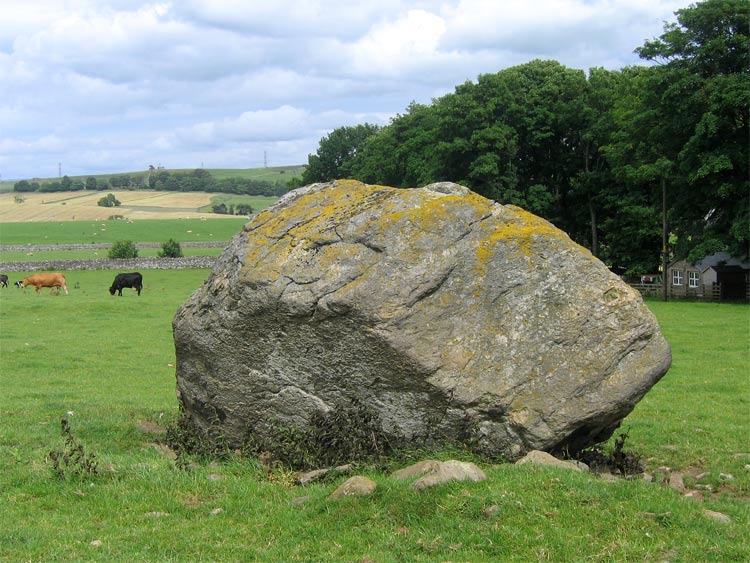
Thunder Stone submitted by LivingRocks on 7th Jul 2005. The enormous Thunder Stone, the largest stone of the Shap Avenue.
(View photo, vote or add a comment)
Log Text: Return visit 5th July 2014: We recently obtained the farmer's permission to walk across the fields to look at any of the Shap Row Stones on his land. Having woken up after a night of heavy, heavy rain to grey skies, we hopped in the car and went over to the Lake District, where the forecast was much better, having spent half an hour researching the exact position of the stones near Shap Village from a map the Shap Local History Society website (well worth a visit to get further information).
The Thunder Stone field was commanded (literally!) by a young bull who was very protective of his cows and calves, and made a move for us the minute we opened the gate, so we backed off (the farmer did warn us he had a bull in the field, but some bulls can be quite placid if kept at a distance). Having come all this way, I didn't want to go away without a picture, so walked up the farm track in front of High Buildings Farm House and round the back of the barns, to get a photograph from the gate to the field.
There is a smaller stone within this same field, so when we go back to Shap in the autumn, once the undergrowth has died back more), we'll visit again to get some more photographs.
First visit 28th June 2014: We went to have a look at some of the stones in Shap Stone Row, but found it almost impossible to park on the very narrow lanes around Keld. I was curious to see The Thunder Stone, and we managed to squeeze our car into the road junction leading down to Shap Abbey and walked back to look at the stone. It lies within a private field, and a clear view was difficult. I have since written to the landowner to ask for permission to get into the field to take photographs, so I'll see what comes back. There is a footpath along the far edge of the field the stone is in, but this leads away from the stone, so this was the closest we could get for now.
The stone is a little difficult to make out in the photograph I've submitted, as there was a lot of farming 'clutter' around the stone.
