Contributory members are able to log private notes and comments about each site
Sites 4clydesdale7 has logged. View this log as a table or view the most recent logs from everyone
Long Stone (Minchinhampton)
Date Added: 30th May 2011
Site Type: Standing Stones
Country: England (Gloucestershire)
Visited: Yes on 30th May 2011. My rating: Condition 4 Ambience 4 Access 5
Long Stone (Minchinhampton) submitted by TimPrevett on 30th Dec 2009. Sunset 26/12/09 - an unplanned visit to a number of sites in the area.
No maps - just a vague 1970s guidebook - took us a couple hours to locate this having gone from Minchinhampton via Hampton Fields to Tetbury to Avening missing the stone at first by a narrow margin.
Having resigned ourselves to a long barrow this stone was spotted with just a few minutes before the sun went below the horizon.
A very impressive 7 feet tall stone, and make sure to see the smaller stone bisecting the wall ...
(View photo, vote or add a comment)
Log Text: So this stone is from 'The Devil's Churchyard' - it caused HRH to think again when a planning application she made failed because of it
Long Stone, Staunton
Date Added: 14th May 2012
Site Type: Standing Stone (Menhir)
Country: England (Gloucestershire)
Visited: Yes on 14th May 2012. My rating: Condition 3 Ambience 3 Access 5
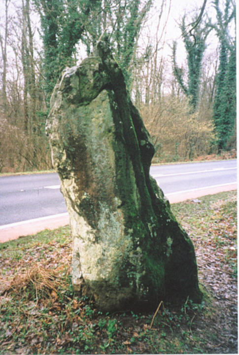
Long Stone, Staunton submitted by hamish on 25th Mar 2004. SO559120 Nr Staunton
This Stone stands by the side of the A4136 about 1 mile from Staunton in the direction of Christchurch.It stands proudly amongst the trees and bushes alone of its kind in this area,although there is a Long Stone near Symonds Yat I believe.It is said that if you prick this stone at midnight it bleeds.
(View photo, vote or add a comment)
Log Text: One of the easier sites to find in the Forest of Dean this stone stands some 8ft high
Lower Swell barrow
Date Added: 15th Jun 2011
Site Type: Chambered Tomb
Country: England (Gloucestershire)
Visited: Yes on 14th Jun 2011. My rating: Condition 3 Ambience 4 Access 3
Lower Swell barrow submitted by thecaptain on 5th Jan 2007. The barrow can be seen under the bushes in its little enclosure at the far side of the cropped field - strangely well down the hillside.
(View photo, vote or add a comment)
Log Text: PWS to NW but also PWE to N and close by but quite difficult to approach is The Tump to the W
Lugbury
Date Added: 8th Sep 2012
Site Type: Chambered Tomb
Country: England (Wiltshire)
Visited: Yes on 28th Aug 2012. My rating: Condition 3 Ambience 3 Access 3
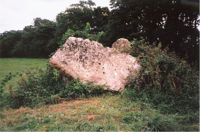
Lugbury submitted by hamish on 11th Jul 2005. The huge capstone leaning against the two uprights.
(View photo, vote or add a comment)
Log Text: This could be a wonderful site to visit if someone showed some care and do some maintenance otherwise one day it will disappear into a veritable jungle - the visible stones are really impressive
Lypiatt Cross
Date Added: 13th Dec 2011
Site Type: Ancient Cross
Country: England (Gloucestershire)
Visited: Yes on 1st Dec 2011. My rating: Condition 4 Ambience 3 Access 5
Lypiatt Cross submitted by 4clydesdale7 on 12th Dec 2011. From the road immediately to the NW
(View photo, vote or add a comment)
Log Text: Probably a 'folly' - very doubtful that it is original
Maes Knoll
Date Added: 5th May 2012
Site Type: Hillfort
Country: England (Somerset)
Visited: Yes on 5th May 2012

Maes Knoll submitted by TheCaptain on 29th Apr 2004. Maes Knoll Hillfort, Norton Malreward, North Somerset, ST600660.
The western end of the fort is made across a narrow neck of the ridge of high land, and consists of a massive ditch and bank, known as “The Tump”, which must be 15 metres high from the ditch to the top.
This is a view to the south from the top of the Tump towards Chew Lake and the Mendips.
(View photo, vote or add a comment)
Log Text: As good a panorama as Solsbury Hill - Dundry Ridge; The Clifton Suspension Bridge; The Severn Bridge; the City of Bristol; the Westbury White Horse; Stanton Drew Great Circle; Chew Valley Lake
Magdalen Mead Well
Date Added: 10th Sep 2011
Site Type: Holy Well or Sacred Spring
Country: England (Gloucestershire)
Visited: Yes on 2nd Sep 2011. My rating: Condition 2 Ambience 3 Access 5
Magdalen Mead Well submitted by 4clydesdale7 on 7th Sep 2011. The Well now converted into two ponds - unfortunately the Water is now unpalatable because of pollution from industry in the area
(View photo, vote or add a comment)
Log Text: Not much evidence of the original well but tidy restoration (creating two ponds) all the same
Money Tump
Date Added: 25th Jun 2011
Site Type: Round Barrow(s)
Country: England (Gloucestershire)
Visited: Yes on 25th Jun 2011. My rating: Condition 2 Ambience 3 Access 4
Money Tump submitted by 4clydesdale7 on 25th Jun 2011. The tump itself from the E - as you can see it's not in a brilliant condition.
(View photo, vote or add a comment)
Log Text: Easy to find and to get to - should be another bowl barrow in next field - but no sign
Nan Tow's Tump
Date Added: 1st Jul 2011
Site Type: Round Barrow(s)
Country: England (Gloucestershire)
Visited: Yes on 30th Jun 2011. My rating: Condition 3 Ambience 4 Access 4
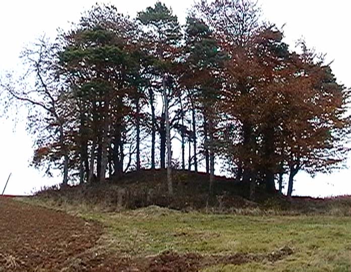
Nan Tow's Tump submitted by Thorgrim on 11th Nov 2003. One of the largest round barrows in Gloucestershire. Nan Tow was a local witch who was buried standing upright in the barrow. It is very dramatic and easy to see from the A46, but there is no convenient place to leave the car. Best bet is to drive down the narrow lane opposite, park where you can and walk back.
(View photo, vote or add a comment)
Log Text: Must return in winter - first visit in height of summer - site heavily overgrown
Near Hearkening Rock
Date Added: 12th Jun 2012
Site Type: Natural Stone / Erratic / Other Natural Feature
Country: Wales (Monmouthshire)
Visited: Yes on 14th May 2012. My rating: Condition 4 Ambience 4 Access 3
Near Hearkening Rock submitted by 4clydesdale7 on 10th Jun 2012. Looking West over the middle of the Rock.
(View photo, vote or add a comment)
Log Text: Great views from this Stone and its close neighbour the Suck Stone
Norbury Hillfort (Colesbourne)
Date Added: 18th Jul 2011
Site Type: Hillfort
Country: England (Gloucestershire)
Visited: Yes on 17th Jul 2011. My rating: Condition 2 Ambience 4 Access 3
Norbury Hillfort (Colesbourne) submitted by 4clydesdale7 on 17th Jul 2011. The NW ditch and bank
(View photo, vote or add a comment)
Log Text: Longish uphill but steady walk along a marked footpath and farm track - views worth it when you get there
Norbury Hillfort (Farmington)
Date Added: 15th Jul 2011
Site Type: Hillfort
Country: England (Gloucestershire)
Visited: Yes on 14th Jul 2011. My rating: Condition 2 Ambience 4 Access 3
Norbury Hillfort (Farmington) submitted by 4clydesdale7 on 15th Jul 2011. The Western Side
(View photo, vote or add a comment)
Log Text: This will take some exploring - all 80+ acres of it
Norbury Hillfort Barrow
Date Added: 15th Jul 2011
Site Type: Chambered Tomb
Country: England (Gloucestershire)
Visited: Yes on 14th Jul 2011. My rating: Condition 1 Ambience 2 Access 4
Norbury Hillfort Barrow submitted by Mr_Nakajima on 3rd Dec 2006. On a trip to the Cotswolds to look at barrows in November 2006 I decided to visit some of the lesser-known ones.
This barrow sits just off a minor road in a field just to the north of a line of trees. In this picture, taken from the road looking south, the mound can just be seen as it is in shadow from the trees, the rest of the field being in sunlight. I estimate it is no more than half a meter high.
The minor road this barrow lies by is narrow but there are plenty of farm gates or passin...
(View photo, vote or add a comment)
Log Text: Outline just discernible - just as well the pasture had been mown recently
Norn's Tump
Date Added: 29th May 2011
Site Type: Chambered Tomb
Country: England (Gloucestershire)
Visited: Yes on 27th May 2011. My rating: Condition 3 Ambience 4 Access 5
Norn's Tump submitted by 4clydesdale7 on 2nd Jun 2011. A very attractive site
(View photo, vote or add a comment)
Log Text: Pleasant site on Golf Course - the site has been plundered long ago
North Cerney 1
Date Added: 24th Sep 2011
Site Type: Chambered Tomb
Country: England (Gloucestershire)
Visited: Yes on 23rd Sep 2011. My rating: Condition 2 Ambience 4 Access 4
North Cerney 1 submitted by 4clydesdale7 on 24th Sep 2011. From the NE
(View photo, vote or add a comment)
Log Text: Experts disagree on GLO 70 but I think it is far more likely to be a Long Barrow
North Cerney 2
Date Added: 24th Sep 2011
Site Type: Round Barrow(s)
Country: England (Gloucestershire)
Visited: Yes on 23rd Sep 2011. My rating: Condition 3 Ambience 4 Access 4
North Cerney 2 submitted by 4clydesdale7 on 24th Sep 2011. The Barrow from the N
(View photo, vote or add a comment)
Log Text: Liked this site - nice spot between Woodmancote and Rendcomb
Notgrove
Date Added: 2nd Sep 2011
Site Type: Long Barrow
Country: England (Gloucestershire)
Visited: Yes on 31st Aug 2011. My rating: Condition 2 Ambience 2 Access 5
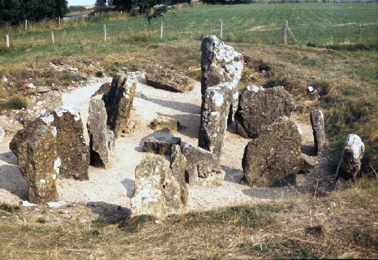
Notgrove submitted by bec-zog on 5th Oct 2003. SP 095212. View of Notgrove Barrow in 1971 when the stones were exposed. Site was subsequently re-covered for protection purposes.
(View photo, vote or add a comment)
Log Text: The GCC Tomb Raider has not been here yet - just general decay
Nottingham Hill
Date Added: 28th Nov 2011
Site Type: Hillfort
Country: England (Gloucestershire)
Visited: Yes on 27th Nov 2011. My rating: Condition 3 Ambience 4 Access 4
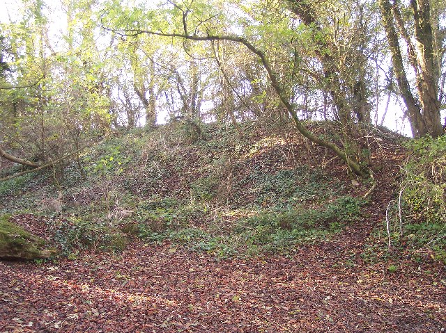
Nottingham Hill submitted by Creative Commons on 23rd Nov 2011. Nottingham Hill Fort Earthworks
The hill Fort on Nottingham Hill is very large. It is defended by two banks and two ditches running across the neck of the hill.
Copyright Bob Embleton and licensed for reuse under the Creative Commons Licence
(View photo, vote or add a comment)
Log Text: The history of this site is fascinating - all sorts of artefacts have been discovered
Nympsfield
Date Added: 30th May 2011
Site Type: Long Barrow
Country: England (Gloucestershire)
Visited: Yes on 22nd May 2011. My rating: Condition 3 Ambience 3 Access 5
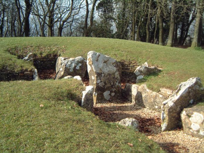
Nympsfield submitted by enkidu41 on 26th Apr 2004. SO 794013
(View photo, vote or add a comment)
Log Text: Manicured to the point almost of being contrived - obviously a well trodden picnic spot with excellent views over the Severn Vale
Odo and Dodo
Date Added: 17th Nov 2011
Site Type: Standing Stones
Country: England (Gloucestershire)
Visited: Yes on 17th Nov 2011. My rating: Condition 3 Ambience 4 Access 3
Odo and Dodo submitted by 4clydesdale7 on 17th Nov 2011. Odo and Dodo with a tree between them in case they argue!
(View photo, vote or add a comment)
Log Text: Stones set in a private garden beside the finish line on the Prescott Hill Climb
