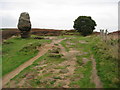
<< Our Photo Pages >> Stanton Moor Cairn T13 - Round Cairn in England in Derbyshire
Submitted by enkidu41 on Tuesday, 26 October 2004 Page Views: 6835
Neolithic and Bronze AgeSite Name: Stanton Moor Cairn T13Country: England County: Derbyshire Type: Round Cairn
Nearest Town: Matlock Nearest Village: Birchover
Map Ref: SK243629
Latitude: 53.162673N Longitude: 1.638008W
Condition:
| 5 | Perfect |
| 4 | Almost Perfect |
| 3 | Reasonable but with some damage |
| 2 | Ruined but still recognisable as an ancient site |
| 1 | Pretty much destroyed, possibly visible as crop marks |
| 0 | No data. |
| -1 | Completely destroyed |
| 5 | Superb |
| 4 | Good |
| 3 | Ordinary |
| 2 | Not Good |
| 1 | Awful |
| 0 | No data. |
| 5 | Can be driven to, probably with disabled access |
| 4 | Short walk on a footpath |
| 3 | Requiring a bit more of a walk |
| 2 | A long walk |
| 1 | In the middle of nowhere, a nightmare to find |
| 0 | No data. |
| 5 | co-ordinates taken by GPS or official recorded co-ordinates |
| 4 | co-ordinates scaled from a detailed map |
| 3 | co-ordinates scaled from a bad map |
| 2 | co-ordinates of the nearest village |
| 1 | co-ordinates of the nearest town |
| 0 | no data |
Internal Links:
External Links:
I have visited· I would like to visit
Couplands visited on 11th Jun 2023 - their rating: Cond: 3 Amb: 4 Access: 4
elad13 visited on 16th Mar 2019 - their rating: Cond: 2 Amb: 4 Access: 2 https://www.youtube.com/watch?v=QaFjBtGDnWs&t=934s - recent search for the Stanton moor aincient sites
Average ratings for this site from all visit loggers: Condition: 2.5 Ambience: 4 Access: 3
")
Stanton Moor Excavations
You may be viewing yesterday's version of this page. To see the most up to date information please register for a free account.
Do not use the above information on other web sites or publications without permission of the contributor.
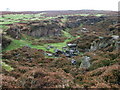
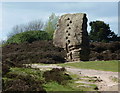
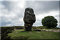
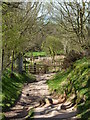
Nearby Images from Geograph Britain and Ireland:
©2008(licence)
©2011(licence)
©2023(licence)
©2011(licence)
©2008(licence)
The above images may not be of the site on this page, they are loaded from Geograph.
Please Submit an Image of this site or go out and take one for us!
Click here to see more info for this site
Nearby sites
Key: Red: member's photo, Blue: 3rd party photo, Yellow: other image, Green: no photo - please go there and take one, Grey: site destroyed
Download sites to:
KML (Google Earth)
GPX (GPS waypoints)
CSV (Garmin/Navman)
CSV (Excel)
To unlock full downloads you need to sign up as a Contributory Member. Otherwise downloads are limited to 50 sites.
Turn off the page maps and other distractions
Nearby sites listing. In the following links * = Image available
90m S 181° Stanton Moor Cairn T14* Cairn (SK24306281)
121m SSE 158° Cork Stone* Natural Stone / Erratic / Other Natural Feature (SK2434662788)
284m WNW 289° Andle Stone (Stanton Moor)* Natural Stone / Erratic / Other Natural Feature (SK2403162993)
356m E 79° Stanton Moor Cairn T25* Cairn (SK24656297)
389m ESE 107° Stanton Moor Cairn (TBC)* Cairn (SK2467562791)
409m E 90° Stanton Moor 4* Ring Cairn (SK24716290)
469m W 267° Doll Tor* Stone Circle (SK2383062873)
567m ENE 66° Stanton Moor Cairn T55* Round Cairn (SK24826313)
615m NE 54° Stanton Moor 3* Stone Circle (SK24806326)
658m NE 50° Stanton Moor Cairn T24* Cairn (SK24806333)
798m E 90° Gorse Stone* Rock Outcrop (SK251629)
805m NE 45° The King (Stanton Moor)* Standing Stone (Menhir) (SK24876347)
847m NE 46° Nine Ladies* Stone Circle (SK24916349)
924m ENE 64° Stanton Moor Cairn T57* Cairn (SK25136331)
984m NNE 24° Stanton Moor Cairn T2* Round Cairn (SK247638)
999m NE 37° Stanton Moor 1* Stone Circle (SK249637)
1.1km SW 225° Rowtor Rocks* Rock Art (SK23556215)
1.1km SW 221° The Megalithic Portal Live in the Derbyshire Peak District Natural Stone / Erratic / Other Natural Feature (SK236621)
1.1km ENE 68° Cat Stone* Rock Outcrop (SK253633)
1.1km SW 223° St Michael’s Church (Birchover)* Carving (SK23576210)
1.4km SW 233° Rockingstone Farm* Rock Outcrop (SK2322062065)
1.7km WSW 250° Cratcliff Rocks* Hillfort (SK227623)
1.7km W 269° Harthill Cairn* Cairn (SK22556286)
1.8km W 268° Nine Stones Cup Mark (Harthill) Rock Art (SK22546284)
1.8km W 262° Nine Stones Close* Stone Circle (SK2253762643)
View more nearby sites and additional images


 We would like to know more about this location. Please feel free to add a brief description and any relevant information in your own language.
 Wir möchten mehr über diese Stätte erfahren. Bitte zögern Sie nicht, eine kurze Beschreibung und relevante Informationen in Deutsch hinzuzufügen.
 Nous aimerions en savoir encore un peu sur les lieux. S'il vous plaît n'hesitez pas à ajouter une courte description et tous les renseignements pertinents dans votre propre langue.
 Quisieramos informarnos un poco más de las lugares. No dude en añadir una breve descripción y otros datos relevantes en su propio idioma.