Featured: Hare and Tabor T Shirts for discerning antiquarians

Hare and Tabor T Shirts for discerning antiquarians

Random Image


Sannaig

Prehistoric Cumbria

Prehistoric Cumbria

Who's Online

There are currently, 366 guests and 1 members online.

You are a guest. To join in, please register for free by clicking here

Sponsors

<< Our Photo Pages >> Gardoms Edge Stone - Standing Stone (Menhir) in England in Derbyshire

Submitted by baz on Tuesday, 27 June 2017  Page Views: 25348

Neolithic and Bronze AgeSite Name: Gardoms Edge Stone
Country: England County: Derbyshire Type: Standing Stone (Menhir)
Nearest Town: Bakewell  Nearest Village: Baslow
Map Ref: SK2725273225  Landranger Map Number: 119
Latitude: 53.255338N  Longitude: 1.592979W
Condition:
5Perfect
4Almost Perfect
3Reasonable but with some damage
2Ruined but still recognisable as an ancient site
1Pretty much destroyed, possibly visible as crop marks
0No data.
-1Completely destroyed
4 Ambience:
5Superb
4Good
3Ordinary
2Not Good
1Awful
0No data.
3 Access:
5Can be driven to, probably with disabled access
4Short walk on a footpath
3Requiring a bit more of a walk
2A long walk
1In the middle of nowhere, a nightmare to find
0No data.
3 Accuracy:
5co-ordinates taken by GPS or official recorded co-ordinates
4co-ordinates scaled from a detailed map
3co-ordinates scaled from a bad map
2co-ordinates of the nearest village
1co-ordinates of the nearest town
0no data
5

Internal Links:
External Links:

I have visited· I would like to visit

Couplands visited on 7th Jul 2023 - their rating: Cond: 4 Amb: 5 Access: 3

mfrincu visited on 19th Mar 2022 - their rating: Cond: 5 Amb: 4 Access: 3

elad13 visited on 2nd Dec 2018 - their rating: Cond: 4 Amb: 4 Access: 2 hwww.youtubettp.com/watch?v=_iTyCRrDNgQ - Youtube video of my recent visit

Catrinm visited on 1st Oct 2017 - their rating: Cond: 3 Amb: 4 Access: 3

dpickup69 visited on 1st Oct 2011 - their rating: Cond: 4 Amb: 4 Access: 2 This whole area is full of archaeological interest, I recommend taking a full day to explore fully. Wrap up warm!

Andy B visited #14 in our rundown of favourite standing stones (and pairs) in Britain. Gardoms Edge Stone (Derbyshire) - quite possibly a Bronze Age sundial. More of Dr Daniel Brown’s research on our pages:

drolaf Andy B rldixon TimPrevett MartinRS mark_a have visited here

Average ratings for this site from all visit loggers: Condition: 4 Ambience: 4.2 Access: 2.6
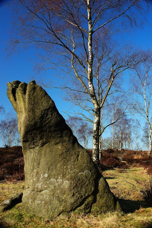
Gardoms Edge Stone
Gardoms Edge Stone submitted by royston7 : Gardoms edge monolith taken from the east showing the ( not quite ) flat north face. See notes in contribution. (Vote or comment on this photo)
Single Standing Stone on Gardoms Edge in Derbyshire with an unusual shape and tilt which resembles a giant sundial. The landscape surrounding the stone harbours many ancient monuments such as Bronze Age roundhouses, a late Neolithic enclosure, and other traces of a long lasting human occupation. The stone is thought to be late Neolithic, set in place around 2000 BC.

Gardom’s Edge is a striking millstone grit ridge less than an hour’s drive from Manchester. Dr Daniel Brown and researchers from Nottingham Trent University have carried out a microtopography survey of the surface surrounding the monolith. Their findings indicate the presence of packing stones around the base of the monolith, evidence that it was placed carefully in position. They have also carried out 3-D modelling of illumination of the stone through the seasons, adapting for changes in the Earth’s tilt to the ecliptic plane over four millennia. See further down this page for more details

Note: New photos of the disappearing shadow on Gardom's Edge standing stone, also see the comments for an update from Daniel Brown who has expanded his ideas into a more general appreciation of the role of shadows in skyscape archaeology
You may be viewing yesterday's version of this page. To see the most up to date information please register for a free account.
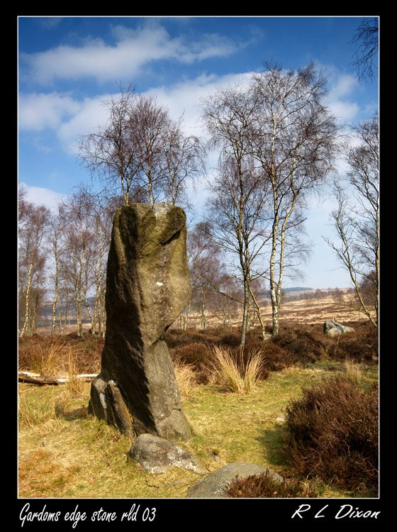

Gardoms Edge Stone
Gardoms Edge Stone submitted by rldixon : Gardoms edge standing stone 24-3-2011 (3 comments - Vote or comment on this photo)

Gardoms Edge Stone
Gardoms Edge Stone submitted by Blingo_von_Trumpenstein : Gardoms Edge standing stone. Summer 2009. Green mottled Danish thick butted 4 side mirror-polished "mellembladed" axe perched on top. Enjoy Blingo (Vote or comment on this photo)

Gardoms Edge Stone
Gardoms Edge Stone submitted by royston7 : The face of Froggatt Edge as seen from a point on an alignment of 320' from the Gardens Edge menhir. Note that by moving 100 metres either north or south of the menhir the flat face is not seen. (2 comments - Vote or comment on this photo)

Gardoms Edge Stone
Gardoms Edge Stone submitted by rldixon : gardoms edge standing stone 24-3-2011 (Vote or comment on this photo)

Gardoms Edge Stone
Gardoms Edge Stone submitted by rldixon : standing stone at gardoms edge 24-3-2011

Gardoms Edge Stone
Gardoms Edge Stone submitted by baz : We visited this splendid standing stone (3 comments)

Gardoms Edge Stone
Gardoms Edge Stone submitted by rldixon : whatever it was that dees saw in aprill 2006 its still here in march 2011 i didnt take too much notice of the stone as i was more interested in the cup and rings stone i didnt realise this image of a man was there untill i read up on it when i got home i managed to zoom in on one of my photos and found it i will have to do my recerch before i go out next time not when i get home ;-) (7 comments)

Gardoms Edge Stone
Gardoms Edge Stone submitted by dees : Please look at the two images of this standing stone taken by me in February 2006. Am I seeing things or is there a small carving of a figure presented? Any comments please - not sure if this is fantasy projection on my part! (6 comments)

Gardoms Edge Stone
Gardoms Edge Stone submitted by royston7 : A closer look at the face of Froggatt Edge 320' NW of the menhir.

Gardoms Edge Stone
Gardoms Edge Stone submitted by royston7 : Taken 21st November looking due south. the sun is low in the sky at noon but central over the menhir.

Gardoms Edge Stone
Gardoms Edge Stone submitted by Andy B : Microtopology: This contour map indicates the possible location of packing stones and their increase density towards the NW base of the Monolith. Credit: D Brown/Nottingham Trent University

Gardoms Edge Stone
Gardoms Edge Stone submitted by Andy B : Gardom Monolith: View towards the south. This image shows how the north-facing side remains in shadow in the winter half year even during midday. Credit: D Brown/Nottingham Trent University

Gardoms Edge Stone
Gardoms Edge Stone submitted by Andy B : Gardom Monolith: Image from the team’s photographic survey (Oct 2011), taken looking directly to the west. Note the triangular shape and flat north facing side. Credit: D Brown/Nottingham Trent University

Gardoms Edge Stone
Gardoms Edge Stone submitted by TimPrevett : The sun coming through one of the very well weathered grooves atop the standing stone.

Gardoms Edge Stone
Gardoms Edge Stone submitted by TimPrevett : This is the second time a Megalithic Meet has taken in this fine standing stone, and again it proved to be a place of prolonged focus and conversation. (1 comment)

Gardoms Edge Stone
Gardoms Edge Stone submitted by dees : Looks like the first photo didn't attach so sending it again - you can just see the position of the supposed figure off centre to the right - Dees (1 comment)

Gardoms Edge Stone
Gardoms Edge Stone submitted by lscollinson : An enigma and awkward to find, but that's the Gardoms Edge sites for you.

Gardoms Edge Stone
Gardoms Edge Stone submitted by elad13 : Gardoms Edge Stone winter 2018

Gardoms Edge Stone
Gardoms Edge Stone submitted by drolaf : Slanted standing stone Gardom's edge

Gardoms Edge Stone
Gardoms Edge Stone submitted by royston7 : 1300 hrs BST 21st June 2017 and the north face of gardoms edge stone is fully illuminated. Here you can also make out the so called " little man ".

Gardoms Edge Stone
Gardoms Edge Stone submitted by royston7 : Taken at mid-day on 21st June with the sun at it's zenith. The north face is now fully illuminated. Note that this was taken at 1300 hrs BST.

Gardoms Edge Stone
Gardoms Edge Stone submitted by royston7 : Taken mid-day on 21st June with sun at it's zenith. Now resembles a " little man ". Note no photo manipulation.

Gardoms Edge Stone
Gardoms Edge Stone submitted by postman : peering through the trees

Gardoms Edge Stone
Gardoms Edge Stone submitted by postman : and peeping through the trees

These are just the first 25 photos of Gardoms Edge Stone. If you log in with a free user account you will be able to see our entire collection.

Do not use the above information on other web sites or publications without permission of the contributor.
Click here to see more info for this site

Nearby sites

Click here to view sites on an interactive OS map

Key: Red: member's photo, Blue: 3rd party photo, Yellow: other image, Green: no photo - please go there and take one, Grey: site destroyed

Download sites to:
KML (Google Earth)
GPX (GPS waypoints)
CSV (Garmin/Navman)
CSV (Excel)

To unlock full downloads you need to sign up as a Contributory Member. Otherwise downloads are limited to 50 sites.


Turn off the page maps and other distractions

Nearby sites listing. In the following links * = Image available
 91m WSW 255° Gardoms Edge Enclosure* Causewayed Enclosure (SK2716473201)
 166m ENE 63° Gardoms Edge Cairns* Barrow Cemetery (SK27407330)
 191m S 170° Gardoms Edge 1* Rock Art (SK2728573037)
 273m ENE 79° Gardoms Edge 02 (Baslow) Rock Art (SK27527328)
 381m ENE 73° Gardoms Edge 2 (Baslow)* Rock Art (SK2761773339)
 460m SSW 192° Three Men of Gardoms* Round Barrow(s) (SK2716172774)
 838m S 170° Gardoms Edge Ringcairn* Ring Cairn (SK274724)
 1.2km SE 125° Birchen Edge Stone* Natural Stone / Erratic / Other Natural Feature (SK28207256)
 1.3km SE 131° Birchen Edge 2 Ring Cairn (SK282724)
 1.3km ENE 78° Birchen Edge 1* Ring Cairn (SK285735)
 1.5km WSW 254° Lady Well Wall* Holy Well or Sacred Spring (SK258728)
 1.8km N 359° Swine Sty* Ancient Village or Settlement (SK272750)
 1.8km SSW 195° Dobb Edge Cup and Ring* Rock Art (SK268715)
 2.0km N 353° Barbrook 5* Ring Cairn (SK270752)
 2.2km N 7° Big Moor* Ancient Village or Settlement (SK275754)
 2.4km N 10° Barbrook Cupmarked Stone* Standing Stone (Menhir) (SK27647560)
 2.4km NNE 15° Barbrook 1* Stone Circle (SK27857558)
 2.5km NNE 16° Barbrook cairn* Cairn (SK27917561)
 2.5km SSE 158° Gibbet Moor South* Ancient Village or Settlement (SK282709)
 2.5km NNE 13° Big Moor Cairn Field* Barrow Cemetery (SK278757)
 2.6km N 8° Big Moor Cairns SW* Barrow Cemetery (SK27587579)
 2.6km SSE 166° Gibbet Moor 1 Cairn (SK279707)
 2.6km SSE 164° Gibbet Moor 3 Cairn (SK280707)
 2.6km SSE 164° Gibbet Moor 2 Cairn (SK280707)
 2.6km N 11° Barbrook 2* Stone Circle (SK27757582)
View more nearby sites and additional images

<< Dolmen Serre de Boisset 2

Monks Cross >>

Please add your thoughts on this site

Explore Green Men

Explore Green Men

Sponsors

Auto-Translation (Google)

Translate from English into:

"Gardoms Edge Stone" | Login/Create an Account | 9 News and Comments
  
Go back to top of page    Comments are owned by the poster. We aren't responsible for their content.
Gardom's Edge map and audio tour / trail by Andy B on Monday, 07 May 2018
(User Info | Send a Message)
A number of archaeological excavations on this rich historical site have uncovered many treasures. You can visit the site of a roundhouse dating back 3000 years, and there is widespread further evidence of bronze and iron age settlement - including rock art engraved into the gritstone, ring cairns and standing stones.

Starting Point: National Park car park adjacent to the Robin Hood Inn (Ordnance Survey grid reference - SK280721)
Distance: 2.25 miles / 3.6 km
Grade: Moderate/Easy
Allow: 2 hours
Map: Explorer OL24 The Peak District - White Peak Area
Terrain: Muddy in places during wet periods. Fairly level route. Two stiles to cross
Nearest Town: Baslow

Travel Information: The 170 bus service operates between Chesterfield and Baslow. The nearest car park is illustrated next to the start point.

https://www.moorsforthefuture.org.uk/enjoy-the-moors/audio-trails/gardoms-edge
[ Reply to This ]

Re: Derbyshire Peak District stone 'may be Neolithic sundial' by drolaf on Monday, 11 September 2017
(User Info | Send a Message)
visited 07/09/2017
The birch wood has grown a bit from the time of the photos.
follow the path north through the gate where the fence meets wall.
[ Reply to This ]

Phenomenology Of Shadow - Daniel Brown by Andy B on Tuesday, 27 June 2017
(User Info | Send a Message)
PHENOMENOLOGY OF SHADOW - Daniel Brown, Nottingham Trent University, School of Science and Technology
in Mediterranean Archaeology and Archaeometry, Vol. 16, No 4

Experiencing the landscape and skyscape in which for example an astronomically relevant ancient site is located allows for a deep exploration of possible meanings of embedded alignments.

In Skyscape Archaeology phenomenology of the landscape is commonly used. Following from this approach and similar to the phenomenology of nature inspired by Goethe, a deep and detailed engagement with a site and standing stones can offer the opportunity to tap into meanings so far overlooked.

The following will illustrate how the experience of shadows cast by and on a standing stone at Gardom’s Edge can add to an archaeoastronomical narrative. During the summer solstice the stone seems to lose its shadow or embody it in stone. When looking at anthropological evidence, the shadow can be an essential part of any
living being.

It becomes clear that a monument with a lost shadow has gained an added
dimension of power and liminality; thereby possibly constraining its position within the landscape. Using this example, a more general phenomenology of shadows will be developed that can allow other researchers to find their way into a deeper and richer engagement with a site or monument. Ultimately, it will allow
another avenue towards skyscape archaeology

http://maajournal.com/Issues/2016/Vol16-4/Full4.pdf

http://www.maajournal.com/Issues2016d.php

http://irep.ntu.ac.uk/id/eprint/29590/
[ Reply to This ]

Video Talk: Dr Dan Brown - Astronomy of the standing stone on Gardom's Edge by Andy B on Friday, 26 April 2013
(User Info | Send a Message)


Astronomer Dan Brown and Landscape Historian Andy Alder from Nottingham Trent University explain their theory that the standing stone on Gardom's Edge, Derbyshire had an astronomical function including a sundial shadow effect. Set the video to HD for the clearest view of the slides.

The talk is followed by detailed discussion and critique from John Barnatt, Kevin Kilburn and others in the audience. Presented at the Megalithic Portal's Live in the Peak District event in July 2012.

http://www.youtube.com/watch?v=RLNAV6_J3Gw

See also the images above and news reports below for more information.
[ Reply to This ]
    A Possible Astronomically Aligned Monolith at Gardom's Edge by Andy B on Wednesday, 10 July 2019
    (User Info | Send a Message)
    A Possible Astronomically Aligned Monolith at Gardom's Edge
    D. Brown, A. Alder, E. Bemand
    (Submitted on 5 Mar 2012)

    A unique triangular shaped monolith located within the Peak District National Park at Gardom's Edge could be intentionally astronomically aligned. It is set within a landscape rich in late Neolithic and Bronze Age remains. We show that the stone is most likely in its original orientation owing to its clear signs of erosion and associated to the time period of the late Neolithic. It is tilted towards South and its North side slopes at an angle equal to the maximum altitude of the Sun at mid-summer. This alignment emphasizes the changing declinations of the Sun during the seasons as well as giving an indication of mid-summers day. This functionality is achieved by an impressive display of light and shadow on the North-facing side of the Monolith. Together with other monuments in the close vicinity the monolith would have represented an ideal marker or social arena for seasonal gatherings for the else dispersed small communities.

    5 pages, 5 figures, submitted for conference proceedings of SEAC 2011
    Summary:
    https://arxiv.org/abs/1203.0947

    Paper:
    https://arxiv.org/ftp/arxiv/papers/1203/1203.0947.pdf
    [ Reply to This ]

Re: Gardoms Edge Stone by Anonymous on Wednesday, 04 April 2012
This looks like a foot.
[ Reply to This ]

More evidence that monolith at Gardom’s Edge may be astronomically aligned by Andy B on Wednesday, 28 March 2012
(User Info | Send a Message)
Researchers at the Nottingham Trent University have gathered new evidence that a 4000-year-old monolith may have been aligned to be an astronomical marker. The 2.2 metre high monument, located in the Peak District National Park, has a striking, right-angled triangular shape that slants up towards geographic south. The orientation and inclination of the slope is aligned to the altitude of the Sun at mid-summer. The researchers believe that the monolith was set in place to give symbolic meaning to the location through the changing seasonal illuminations. Dr Daniel Brown presented the findings on 27th March at the National Astronomy Meeting in Manchester.

The rare example of a monolith is located at Gardom’s Edge, a striking millstone grit ridge less than an hour’s drive from Manchester. The researchers have carried out a microtopography survey of the surface surrounding the monolith. Their findings indicate the presence of packing stones around the base of the monolith, evidence that it was placed carefully in position. They have also carried out 3-D modelling of illumination of the stone through the seasons, adapting for changes in the Earth’s tilt to the ecliptic plane over four millennia.

The landscape surrounding the stone harbours many ancient monuments such as Bronze Age roundhouses, a late Neolithic enclosure, and other traces of a long lasting human occupation. The researchers believe that the stone is also late Neolithic, set in place around 2000 BC.

"Given the sensitivity of the site, we can't probe under the surface of the soil. However, through our survey, we have found a higher density of packing stones on one side, supporting the case that the stone has been orientated intentionally," said Dr Brown.

The 3-D modelling shows that during the winter half-year, the slanted side of the stone would remain in permanent shadow; during most of the summer half-year it would only be illuminated during the morning and afternoon; close to midsummer it would be illuminated all day. The researchers are currently backing up the modelling work by gathering contemporary photographic evidence of the stone.

"The stone would have been an ideal marker for a social arena for seasonal gatherings," said Dr Brown. "It's not a sundial in the sense that people would have used it to determine an exact time. We think that it was set in position to give a symbolic meaning to its location, a bit like the way that some religious buildings are aligned in a specific direction for symbolic reasons."

The researchers hope that the new evidence will support the case for a wider archaeological survey of the site.

"The use of shadow casting in monuments of this period is quite rare in the British Isles," said Dr Brown. "But there are some examples including Newgrange, Ireland, and some Clava cairns in the north-east of Scotland that have been proposed to include the intentional use of shadows. Both are associated to burial sites using the symbolism of a cyclic light and shadow display to represent eternity. Given the proximity of the Neolithic enclosure and possible ritual importance of this site, the Gardom's Edge monolith could be another such example."

Source: NAM Press Release

See our main page above for the photos and diagrams to go with this. The web site for the 3-D survey project is here
http://archaeopoject.pbworks.com/w/page/30712199/Standing%20Stone%20Gardom%27s%20Edge
[ Reply to This ]
    Re: More evidence that monolith at Gardom’s Edge may be astronomically aligned by royston7 on Tuesday, 27 November 2012
    (User Info | Send a Message)
    I have visited this site on numerous occasions throughout the year and would confirm that the north facing side does indeed only become illuminated during brief days in mid-summer. Using an inclinometer I have found that the north face angle varies - it is not flat - between 24' and 27'. The face is well weather worn and serrated - as one would expect - but as the suns upper limb ( in 3000 BC ) would have been about 24' 18" then in all probability it could have been used for the purpose mentioned. As an afterthought has anyone noted that if one stands on the mound situated 2 metres to the south-east, and looks through the (now well worn) groove atop the menhir then an alignment with the prominent face of froggatt edge is apparent. This is roughly - but not quite - where the midsummer sun in 3500 BC would have set. On the question of the "little man" mentioned by other contributors - I have examined this and come to the conclusion that it is only natural weathering. I will be submitting images with reference to this submission. Royston.
    [ Reply to This ]

Derbyshire Peak District stone 'may be Neolithic sundial' by davidmorgan on Tuesday, 27 September 2011
(User Info | Send a Message)
Experts have said a stone in Derbyshire could be a 4,000-year-old seasonal sundial from the Neolithic period.

Nottingham Trent University academics said people from the era could have used the single angular 2.2m (7.22ft) rock to determine the time of year.

The researchers said they were "not surprised" with their findings as rock art had already been found at Gardom's Edge, near Baslow in the Peak District.

The theory has been shared at a European conference in Portugal.

Dr Daniel Brown, the university's lecturer in astronomy and landscape history, presented the research at the European Society for Astronomy in Culture.

"This single standing stone gives us an idea of how ancient man perceived the skies and how ancient monuments and landscapes can reflect this," he said.

"This region has evidence of early settlements, such as rock art, an enclosure and round houses," Dr Brown added.
'Travelled in summer'

Senior lecturer Andy Alder said their theory was an important step forward.

"During the Neolithic period we know that people migrated, they travelled in the summer up to the upland pastures from the lowland dales," he said.

"Due to the angle and the position of the stone, which is pointing due south, it would have enabled people to tell what season it was - so it's a sundial, but it covers the seasonal periods."

The researchers said during the winter the slanted side would have been in permanent shadow, and during most of the summer it would only be illuminated during the morning and afternoon and shadowed during midday.

The slanted side would be illuminated during the entire day, however, during midsummer, the academics added.
http://www.bbc.co.uk/news/uk-england-derbyshire-15018381

Submitted by coldrum.
[ Reply to This ]

Your Name: Anonymous [ Register Now ]
Subject:


Add your comment or contribution to this page. Spam or offensive posts are deleted immediately, don't even bother

<<< What is five plus one as a number? (Please type the answer to this question in the little box on the left)
You can also embed videos and other things. For Youtube please copy and paste the 'embed code'.
For Google Street View please include Street View in the text.
Create a web link like this: <a href="https://www.megalithic.co.uk">This is a link</a>  

Allowed HTML is:
<p> <b> <i> <a> <img> <em> <br> <strong> <blockquote> <tt> <li> <ol> <ul> <object> <param> <embed> <iframe>

We would like to know more about this location. Please feel free to add a brief description and any relevant information in your own language.
Wir möchten mehr über diese Stätte erfahren. Bitte zögern Sie nicht, eine kurze Beschreibung und relevante Informationen in Deutsch hinzuzufügen.
Nous aimerions en savoir encore un peu sur les lieux. S'il vous plaît n'hesitez pas à ajouter une courte description et tous les renseignements pertinents dans votre propre langue.
Quisieramos informarnos un poco más de las lugares. No dude en añadir una breve descripción y otros datos relevantes en su propio idioma.