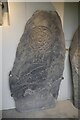
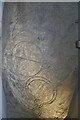
<< Our Photo Pages >> Inveravon (1) - Class I Pictish Symbol Stone in Scotland in Moray
Submitted by golux on Monday, 24 March 2003 Page Views: 6760
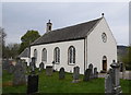
Early Medieval (Dark Age)Site Name: Inveravon (1) Alternative Name: Inveraven 1Country: Scotland County: Moray Type: Class I Pictish Symbol Stone
Map Ref: NJ1828737599 Landranger Map Number: 28
Latitude: 57.421374N Longitude: 3.362194W
Condition:
| 5 | Perfect |
| 4 | Almost Perfect |
| 3 | Reasonable but with some damage |
| 2 | Ruined but still recognisable as an ancient site |
| 1 | Pretty much destroyed, possibly visible as crop marks |
| 0 | No data. |
| -1 | Completely destroyed |
| 5 | Superb |
| 4 | Good |
| 3 | Ordinary |
| 2 | Not Good |
| 1 | Awful |
| 0 | No data. |
| 5 | Can be driven to, probably with disabled access |
| 4 | Short walk on a footpath |
| 3 | Requiring a bit more of a walk |
| 2 | A long walk |
| 1 | In the middle of nowhere, a nightmare to find |
| 0 | No data. |
| 5 | co-ordinates taken by GPS or official recorded co-ordinates |
| 4 | co-ordinates scaled from a detailed map |
| 3 | co-ordinates scaled from a bad map |
| 2 | co-ordinates of the nearest village |
| 1 | co-ordinates of the nearest town |
| 0 | no data |
Internal Links:
External Links:
I have visited· I would like to visit
Klingon visited on 14th Feb 2019 - their rating: Cond: 4 Amb: 4 Access: 4
 (PID:88302)")
Reference:
RCAHMS.
You may be viewing yesterday's version of this page. To see the most up to date information please register for a free account.
 (PID:104416)")
Do not use the above information on other web sites or publications without permission of the contributor.
Nearby Images from Geograph Britain and Ireland:
©2020(licence)
©2020(licence)
©2019(licence)
©2021(licence)
©2019(licence)
The above images may not be of the site on this page, they are loaded from Geograph.
Please Submit an Image of this site or go out and take one for us!
Click here to see more info for this site
Nearby sites
Key: Red: member's photo, Blue: 3rd party photo, Yellow: other image, Green: no photo - please go there and take one, Grey: site destroyed
Download sites to:
KML (Google Earth)
GPX (GPS waypoints)
CSV (Garmin/Navman)
CSV (Excel)
To unlock full downloads you need to sign up as a Contributory Member. Otherwise downloads are limited to 50 sites.
Turn off the page maps and other distractions
Nearby sites listing. In the following links * = Image available
nankm 0° Inveravon* Class I Pictish Symbol Stone (NJ1828737599)
nankm 0° Inveravon (3)* Class I Pictish Symbol Stone (NJ1828737599)
nankm 0° Inveravon (4)* Class I Pictish Symbol Stone (NJ1828737599)
nankm 0° Inveravon (2)* Class I Pictish Symbol Stone (NJ1828737599)
808m NW 324° Pitchroy* Stone Circle (NJ17823826)
1.2km S 178° Marionburgh* Stone Circle (NJ183364)
1.7km S 188° Lower Lagmore* Stone Circle (NJ180359)
1.9km SSW 200° Upper Lagmore* Stone Circle (NJ176358)
2.1km NNW 337° Mains of Kirdells* Round Cairn (NJ175396)
4.8km NNW 336° Leakin* Round Cairn (NJ164420)
5.2km N 2° Knockando 1* Class I Pictish Symbol Stone (NJ186428)
5.2km N 2° Knockando 2* Class I Pictish Symbol Stone (NJ186428)
5.6km N 8° Drum Divan* Stone Circle (NJ192431)
6.5km WSW 238° Advie* Class I Pictish Symbol Stone (NJ12653426)
6.8km S 177° Doune Of Dalmore* Stone Circle (NJ185308)
7.1km SSE 158° Tom Na Heron Class I Pictish Symbol Stone (NJ208310)
8.1km SSE 169° Glenlivet Standing Stone* Standing Stone (Menhir) (NJ19732963)
8.5km S 177° Nethertown Stone Circle (NJ185291)
9.6km ENE 60° The Fairy Knowe* Misc. Earthwork (NJ267422)
9.6km ENE 63° Hatton Circle (Moray)* Stone Circle (NJ270418)
10.1km SSE 164° Auchorachan* Standing Stone (Menhir) (NJ20932780)
12.2km SSW 195° Balneilean Class I Pictish Symbol Stone (NJ149259)
13.2km E 87° Nether Cluny* Stone Circle (NJ315381)
14.0km WNW 285° Lynagowan Stone Circle (NJ048414)
14.1km E 82° Mortlach 2* Class I Pictish Symbol Stone (NJ323392)
View more nearby sites and additional images


 We would like to know more about this location. Please feel free to add a brief description and any relevant information in your own language.
 Wir möchten mehr über diese Stätte erfahren. Bitte zögern Sie nicht, eine kurze Beschreibung und relevante Informationen in Deutsch hinzuzufügen.
 Nous aimerions en savoir encore un peu sur les lieux. S'il vous plaît n'hesitez pas à ajouter une courte description et tous les renseignements pertinents dans votre propre langue.
 Quisieramos informarnos un poco más de las lugares. No dude en añadir una breve descripción y otros datos relevantes en su propio idioma.