
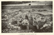

<< Our Photo Pages >> Tempelberg Grabhuegel (Rügen) - Round Barrow(s) in Germany in Mecklenburg-Western Pomerania
Submitted by AlexHunger on Saturday, 25 March 2006 Page Views: 3645
Neolithic and Bronze AgeSite Name: Tempelberg Grabhuegel (Rügen) Alternative Name: Jarnitz GrabhügelCountry: Germany Land: Mecklenburg-Western Pomerania Type: Round Barrow(s)
Nearest Town: Bergen Nearest Village: Ralswiek
Latitude: 54.462240N Longitude: 13.446149E
Condition:
| 5 | Perfect |
| 4 | Almost Perfect |
| 3 | Reasonable but with some damage |
| 2 | Ruined but still recognisable as an ancient site |
| 1 | Pretty much destroyed, possibly visible as crop marks |
| 0 | No data. |
| -1 | Completely destroyed |
| 5 | Superb |
| 4 | Good |
| 3 | Ordinary |
| 2 | Not Good |
| 1 | Awful |
| 0 | No data. |
| 5 | Can be driven to, probably with disabled access |
| 4 | Short walk on a footpath |
| 3 | Requiring a bit more of a walk |
| 2 | A long walk |
| 1 | In the middle of nowhere, a nightmare to find |
| 0 | No data. |
| 5 | co-ordinates taken by GPS or official recorded co-ordinates |
| 4 | co-ordinates scaled from a detailed map |
| 3 | co-ordinates scaled from a bad map |
| 2 | co-ordinates of the nearest village |
| 1 | co-ordinates of the nearest town |
| 0 | no data |
Internal Links:
External Links:
 (PID:67869)")
Ver large barrow on the Island of Rügen.
You may be viewing yesterday's version of this page. To see the most up to date information please register for a free account.
Do not use the above information on other web sites or publications without permission of the contributor.
Nearby Images from Flickr
The above images may not be of the site on this page, but were taken nearby. They are loaded from Flickr so please click on them for image credits.
Click here to see more info for this site
Nearby sites
Click here to view sites on an interactive map of the areaKey: Red: member's photo, Blue: 3rd party photo, Yellow: other image, Green: no photo - please go there and take one, Grey: site destroyed
Download sites to:
KML (Google Earth)
GPX (GPS waypoints)
CSV (Garmin/Navman)
CSV (Excel)
To unlock full downloads you need to sign up as a Contributory Member. Otherwise downloads are limited to 50 sites.
Turn off the page maps and other distractions
Nearby sites listing. In the following links * = Image available
1.1km NNE 31° Augustenhof Grabhuegelfeld* Barrow Cemetery
1.8km NW 322° Gnies Grabhuegel 2* Round Barrow(s)
2.0km WNW 300° Gnies Grabhuegel 1* Round Barrow(s)
2.1km WSW 249° Dramwitz Grabhügel 3* Round Barrow(s)
2.3km WSW 242° Dramwitz Grabhügel 1 Round Barrow(s)
2.6km WSW 241° Dramwitz Grabhügel 2 Round Barrow(s)
3.4km SSE 157° Buschvitz Grabhuegelgruppe Barrow Cemetery
3.5km W 264° Patzig Grabhügel 2* Round Barrow(s)
3.5km W 265° Patzig Grabhügel 1* Round Barrow(s)
4.0km WNW 290° Woorke Grabhügel 12* Round Barrow(s)
4.0km WNW 292° Woorke Grabhügel 10* Round Barrow(s)
4.0km WNW 290° Woorke Grabhügel 11* Round Barrow(s)
4.1km WNW 291° Woorke Grabhügel 9* Round Barrow(s)
4.1km WNW 287° Woorke Grabhügel 7* Round Barrow(s)
4.2km WNW 288° Woorke Grabhügel 5* Round Barrow(s)
4.2km WNW 290° Woorke Grabhügel 8* Round Barrow(s)
4.2km WNW 288° Woorke Grabhügel 6* Round Barrow(s)
4.3km WNW 285° Woorke Grabhügel 2* Round Barrow(s)
4.3km WNW 287° Woorke Grabhügel 4* Round Barrow(s)
4.3km WNW 286° Woorke Grabhügel 3* Round Barrow(s)
4.3km WNW 286° Woorke Grabhügel 1* Round Barrow(s)
4.5km WNW 285° Woorke Grabhügel 0* Round Barrow(s)
4.5km S 181° Slawenburg Rugard* Hillfort
5.0km SSE 161° Dumsevitz Grabhügel Round Barrow(s)
5.1km S 190° Bildstein Marienkirche* Carving
View more nearby sites and additional images


 We would like to know more about this location. Please feel free to add a brief description and any relevant information in your own language.
 Wir möchten mehr über diese Stätte erfahren. Bitte zögern Sie nicht, eine kurze Beschreibung und relevante Informationen in Deutsch hinzuzufügen.
 Nous aimerions en savoir encore un peu sur les lieux. S'il vous plaît n'hesitez pas à ajouter une courte description et tous les renseignements pertinents dans votre propre langue.
 Quisieramos informarnos un poco más de las lugares. No dude en añadir una breve descripción y otros datos relevantes en su propio idioma.