

<< Our Photo Pages >> Venac Hillfort - Hillfort in Croatia
Submitted by AlexHunger on Tuesday, 17 May 2005 Page Views: 4990
Iron Age and Later PrehistorySite Name: Venac HillfortCountry: Croatia Type: Hillfort
Nearest Town: Zadar Nearest Village: Ljubac
Latitude: 44.273780N Longitude: 15.302280E
Condition:
| 5 | Perfect |
| 4 | Almost Perfect |
| 3 | Reasonable but with some damage |
| 2 | Ruined but still recognisable as an ancient site |
| 1 | Pretty much destroyed, possibly visible as crop marks |
| 0 | No data. |
| -1 | Completely destroyed |
| 5 | Superb |
| 4 | Good |
| 3 | Ordinary |
| 2 | Not Good |
| 1 | Awful |
| 0 | No data. |
| 5 | Can be driven to, probably with disabled access |
| 4 | Short walk on a footpath |
| 3 | Requiring a bit more of a walk |
| 2 | A long walk |
| 1 | In the middle of nowhere, a nightmare to find |
| 0 | No data. |
| 5 | co-ordinates taken by GPS or official recorded co-ordinates |
| 4 | co-ordinates scaled from a detailed map |
| 3 | co-ordinates scaled from a bad map |
| 2 | co-ordinates of the nearest village |
| 1 | co-ordinates of the nearest town |
| 0 | no data |
Internal Links:
External Links:
")
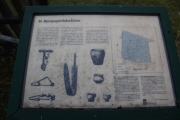
This is an imposing 200 Meter diameter Liburnian Illyrian Iron Age Hillfort with 4 wide terraces cut into the hill side at 78 Meters Altitude. On the south side, there is a massive irregular defensive wall out of lose material. This culture buried their dead in the Kosa tumuli field 400 meters to the South East.
You may be viewing yesterday's version of this page. To see the most up to date information please register for a free account.
")
")
")
Do not use the above information on other web sites or publications without permission of the contributor.
Nearby Images from Flickr

The above images may not be of the site on this page, but were taken nearby. They are loaded from Flickr so please click on them for image credits.
Click here to see more info for this site
Nearby sites
Click here to view sites on an interactive map of the areaKey: Red: member's photo, Blue: 3rd party photo, Yellow: other image, Green: no photo - please go there and take one, Grey: site destroyed
Download sites to:
KML (Google Earth)
GPX (GPS waypoints)
CSV (Garmin/Navman)
CSV (Excel)
To unlock full downloads you need to sign up as a Contributory Member. Otherwise downloads are limited to 50 sites.
Turn off the page maps and other distractions
Nearby sites listing. In the following links * = Image available
505m SSE 168° Kosa Tumuli 9* Round Barrow(s)
592m SSE 155° Kosa Tumuli 8* Round Barrow(s)
791m SSE 152° Kosa Tumuli 2* Round Barrow(s)
1.4km SE 145° Kosa Tumuli 1* Round Barrow(s)
7.3km ESE 117° Nin Temple* Ancient Temple
11.0km WSW 244° Prahulje Tumulus* Artificial Mound
18.7km SSW 199° Zadar Museum* Museum
27.8km SSE 165° Vrcevo Hill Hillfort
28.4km SSE 165° Possible Illyrian site near Raštane Donj Ancient Village or Settlement
41.4km SE 135° Asseria Hillfort* Hillfort
58.1km SE 132° Varvaria* Hillfort
65.3km SE 143° Arauzona Hillfort* Hillfort
80.6km SE 130° Pokrovnik Ancient Village or Settlement
110.6km SE 138° Sutilija Hillfort* Hillfort
119.5km NW 321° Tramuntana Well* Holy Well or Sacred Spring
119.5km NW 321° Tramuntana Portal Tomb* Portal Tomb
119.5km NW 322° Beli wall petroglyph* Rock Art
119.7km NW 321° Tramuntana Dolmen 2* Burial Chamber or Dolmen
120.1km NW 322° Tramuntana Dolmen 1* Burial Chamber or Dolmen
124.1km SE 133° Split Archaeological Museum* Museum
124.7km SE 133° Diocletian's Palace* Ancient Palace
125.0km SE 130° Salona Town wall* Hillfort
125.0km SE 130° Solin Town Gate* Ancient Village or Settlement
126.0km SE 129° Klis Hillfort* Hillfort
127.5km NW 305° Nesactium Hillfort* Hillfort
View more nearby sites and additional images


 We would like to know more about this location. Please feel free to add a brief description and any relevant information in your own language.
 Wir möchten mehr über diese Stätte erfahren. Bitte zögern Sie nicht, eine kurze Beschreibung und relevante Informationen in Deutsch hinzuzufügen.
 Nous aimerions en savoir encore un peu sur les lieux. S'il vous plaît n'hesitez pas à ajouter une courte description et tous les renseignements pertinents dans votre propre langue.
 Quisieramos informarnos un poco más de las lugares. No dude en añadir una breve descripción y otros datos relevantes en su propio idioma.