


<< Our Photo Pages >> Blocc and Bluigne - Standing Stones in Ireland (Republic of) in Co. Meath
Submitted by Klingon on Wednesday, 18 May 2005 Page Views: 7589
Neolithic and Bronze AgeSite Name: Blocc and BluigneCountry: Ireland (Republic of) County: Co. Meath Type: Standing Stones
Nearest Town: Navan Nearest Village: Kilmessan
Map Ref: N9206359823
Latitude: 53.580398N Longitude: 6.610771W
Condition:
| 5 | Perfect |
| 4 | Almost Perfect |
| 3 | Reasonable but with some damage |
| 2 | Ruined but still recognisable as an ancient site |
| 1 | Pretty much destroyed, possibly visible as crop marks |
| 0 | No data. |
| -1 | Completely destroyed |
| 5 | Superb |
| 4 | Good |
| 3 | Ordinary |
| 2 | Not Good |
| 1 | Awful |
| 0 | No data. |
| 5 | Can be driven to, probably with disabled access |
| 4 | Short walk on a footpath |
| 3 | Requiring a bit more of a walk |
| 2 | A long walk |
| 1 | In the middle of nowhere, a nightmare to find |
| 0 | No data. |
| 5 | co-ordinates taken by GPS or official recorded co-ordinates |
| 4 | co-ordinates scaled from a detailed map |
| 3 | co-ordinates scaled from a bad map |
| 2 | co-ordinates of the nearest village |
| 1 | co-ordinates of the nearest town |
| 0 | no data |
Internal Links:
External Links:
I have visited· I would like to visit
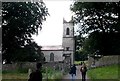
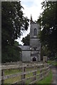
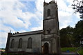
wcdarling visited on 19th Nov 2018 - their rating: Cond: 5 Amb: 5 Access: 4 While I was visiting the site to see the larger Hill of Tara and its stones, tomb and earthworks, I was excited when our tour guide pointed these out as well. They are located in the old churchyard next to St. Patrick’s, a 19th century church, now deconsecrated. The church is the nearest site to the parking lot so they’re easy to see. While on a grassy rise, they ground in front of them is flat and I would say it’s accessible.
kith visited on 1st Sep 2007 - their rating: Cond: 3 Amb: 3 Access: 5
Klingon visited on 2nd Apr 2005 - their rating: Cond: 3 Amb: 5 Access: 5
PERKYPUFFIN have visited here
Average ratings for this site from all visit loggers: Condition: 3.67 Ambience: 4.33 Access: 4.67
")
You may be viewing yesterday's version of this page. To see the most up to date information please register for a free account.
")
")
")
Do not use the above information on other web sites or publications without permission of the contributor.
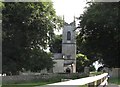
Nearby Images from Geograph Britain and Ireland:
©2015(licence)
©2013(licence)

©2013(licence)
©2018(licence)
©2018(licence)
The above images may not be of the site on this page, they are loaded from Geograph.
Please Submit an Image of this site or go out and take one for us!
Click here to see more info for this site
Nearby sites
Click here to view sites on an interactive map of the areaKey: Red: member's photo, Blue: 3rd party photo, Yellow: other image, Green: no photo - please go there and take one, Grey: site destroyed
Download sites to:
KML (Google Earth)
GPX (GPS waypoints)
CSV (Garmin/Navman)
CSV (Excel)
To unlock full downloads you need to sign up as a Contributory Member. Otherwise downloads are limited to 50 sites.
Turn off the page maps and other distractions
Nearby sites listing. In the following links * = Image available
125m SSW 203° Hill of Tara* Passage Grave (N9201659707)
154m SE 142° King Cormacs Well* Holy Well or Sacred Spring (SA9500819076)
216m SSW 205° Lia Fail* Standing Stone (Menhir) (N9197659625)
725m S 186° Tuath Linde* Holy Well or Sacred Spring (N920591)
1.5km S 172° Rath Maeve* Henge
2.2km NE 39° Lismullin Henge Henge (N93426156)
2.4km NE 52° Rath Lugh* Promontory Fort / Cliff Castle (N939613)
6.2km SE 132° Moyer Carns Cairn
7.0km SSE 158° Moybologue Cemetery Artificial Mound
10.1km ESE 104° Kilbrew Henge
10.2km NW 325° Donaghmore Stone Circle (N860680)
14.8km NE 36° Recently Discovered Prehistoric Cropmark near Newgrange* Misc. Earthwork
15.4km NE 37° Newgrange Barrow ME019-049001* Chambered Tomb (SB0500930882)
15.5km NE 35° Newgrange Stone Circle* Stone Circle (O007727)
15.5km NE 35° Newgrange* Passage Grave (O00747272)
15.6km NNE 30° Knowth Timber Circle* Timber Circle (N997734)
15.6km NNE 30° Knowth* Passage Grave (N99697342)
15.8km NNE 16° Hill of Slane* Artificial Mound
15.8km NE 38° Newgrange Standing Stones* Standing Stones
17.3km NE 38° Dowth Passage Grave* Passage Grave (O02377377)
17.7km NE 40° Donore Mystery Mound Artificial Mound (O0334573550)
17.9km NE 39° Dowth Hall* Passage Grave
18.3km NE 39° Dowth Henge* Henge (O034742)
18.5km E 81° Micknanstown* Passage Grave
18.8km NNE 34° Townleyhall Passage Tomb* Passage Grave (O0222075723)
View more nearby sites and additional images


 We would like to know more about this location. Please feel free to add a brief description and any relevant information in your own language.
 Wir möchten mehr über diese Stätte erfahren. Bitte zögern Sie nicht, eine kurze Beschreibung und relevante Informationen in Deutsch hinzuzufügen.
 Nous aimerions en savoir encore un peu sur les lieux. S'il vous plaît n'hesitez pas à ajouter une courte description et tous les renseignements pertinents dans votre propre langue.
 Quisieramos informarnos un poco más de las lugares. No dude en añadir una breve descripción y otros datos relevantes en su propio idioma.