

<< Our Photo Pages >> Balmalloch Cairnfield - Barrow Cemetery in Scotland in South Ayrshire
Submitted by markj99 on Friday, 27 October 2023 Page Views: 97
Neolithic and Bronze AgeSite Name: Balmalloch CairnfieldCountry: Scotland County: South Ayrshire Type: Barrow Cemetery
Nearest Town: Girvan Nearest Village: Barrhill
Map Ref: NX26488439
Latitude: 55.123418N Longitude: 4.722754W
Condition:
| 5 | Perfect |
| 4 | Almost Perfect |
| 3 | Reasonable but with some damage |
| 2 | Ruined but still recognisable as an ancient site |
| 1 | Pretty much destroyed, possibly visible as crop marks |
| 0 | No data. |
| -1 | Completely destroyed |
| 5 | Superb |
| 4 | Good |
| 3 | Ordinary |
| 2 | Not Good |
| 1 | Awful |
| 0 | No data. |
| 5 | Can be driven to, probably with disabled access |
| 4 | Short walk on a footpath |
| 3 | Requiring a bit more of a walk |
| 2 | A long walk |
| 1 | In the middle of nowhere, a nightmare to find |
| 0 | No data. |
| 5 | co-ordinates taken by GPS or official recorded co-ordinates |
| 4 | co-ordinates scaled from a detailed map |
| 3 | co-ordinates scaled from a bad map |
| 2 | co-ordinates of the nearest village |
| 1 | co-ordinates of the nearest town |
| 0 | no data |
Internal Links:
External Links:
I have visited· I would like to visit
markj99 visited on 25th Oct 2023 - their rating: Cond: 1 Amb: 3 Access: 1 In its current condition Balmalloch Cairnfield is not worth visiting however you can walk through it on the way to Balmalloch Cairn.
")
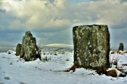
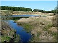
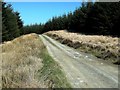
Balmalloch Cairnfield is located in a pine forest clearing c. 2.5 miles NE of Barrhill, a village in South Ayrshire. The extensive site is centred on NX 2648 8439. According to Canmore ID 62526 there were around 23 small cairns S of Balmalloch Chambered Cairn. The largest cairn measured c. 6m in diameter and 0.8m high.
Unfortunately, Balmalloch Cairnfield has been furrowed and planted with pine trees. This has effectively destroyed the site. I couldn't see any remaining mounds on my visit on 25.10.23. When the trees are harvested in due course there will be further damage to Balmalloch Cairnfield.
You may be viewing yesterday's version of this page. To see the most up to date information please register for a free account.
Do not use the above information on other web sites or publications without permission of the contributor.
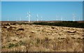
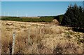
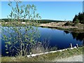
Nearby Images from Geograph Britain and Ireland:
©2011(licence)
©2011(licence)
©2011(licence)
©2011(licence)
©2011(licence)
The above images may not be of the site on this page, they are loaded from Geograph.
Please Submit an Image of this site or go out and take one for us!
Click here to see more info for this site
Nearby sites
Key: Red: member's photo, Blue: 3rd party photo, Yellow: other image, Green: no photo - please go there and take one, Grey: site destroyed
Download sites to:
KML (Google Earth)
GPX (GPS waypoints)
CSV (Garmin/Navman)
CSV (Excel)
To unlock full downloads you need to sign up as a Contributory Member. Otherwise downloads are limited to 50 sites.
Turn off the page maps and other distractions
Nearby sites listing. In the following links * = Image available
169m NW 325° Balmalloch Chambered Cairn* Chambered Cairn (NX2638784532)
1.8km SW 216° Laggan Cairn (Barrhill)* Cairn (NX25358297)
5.0km WSW 245° Barrhill White Cairn* Cairn (NX21898244)
5.9km NW 304° Glake Stone* Standing Stone (Menhir) (NX21678790)
6.8km SSW 209° Laggish White Cairn* Cairn (NX22987860)
6.8km SE 129° Cairnderry* Chambered Cairn (NX31597993)
7.3km E 92° Sheuchan's Cairn* Chambered Cairn (NX33798387)
7.4km S 170° Arnsheen N* Cairn (NX2753877059)
7.4km S 170° Arnsheen S* Cairn (NX2752777027)
8.9km WSW 254° Arecleoch Standing Stone* Standing Stone (Menhir) (NX178822)
9.3km ESE 122° Bargrennan Burn White Cairn* Cairn (NX34227910)
9.4km ENE 71° Cairnfore* Cairn (NX35548707)
9.6km SW 235° Cave Cairn (Chirmorrie)* Chambered Cairn (NX18317924)
10.6km ESE 122° White Cairn, Bargrennan* Chambered Cairn (NX3524378359)
10.8km SW 234° Arecleoch Chambered Cairn Chambered Cairn (NX175783)
10.9km NW 322° Dinvin Earthworks* Misc. Earthwork (NX2002993173)
11.3km E 82° Kirriemore* Chambered Cairn (NX37738544)
12.4km NE 34° Bencallen Hill* Chambered Cairn (NX33779440)
12.6km SSW 194° Wells of the Rees* Holy Well or Sacred Spring (NX22977232)
12.6km SSW 213° Miltonise North Cairn* Cairn (NX19257405)
12.7km SSW 213° Miltonish Stone Circle (NX192740)
12.8km SE 132° Clachaneasy Bridge* Cairn (NX35647542)
12.8km SW 222° Cairn Kenny* Passage Grave (NX17467525)
12.9km SW 220° Markdhu White Cairn* Cairn (NX17807486)
13.4km SSW 196° Laggangarn* Standing Stones (NX22237166)
View more nearby sites and additional images


 We would like to know more about this location. Please feel free to add a brief description and any relevant information in your own language.
 Wir möchten mehr über diese Stätte erfahren. Bitte zögern Sie nicht, eine kurze Beschreibung und relevante Informationen in Deutsch hinzuzufügen.
 Nous aimerions en savoir encore un peu sur les lieux. S'il vous plaît n'hesitez pas à ajouter une courte description et tous les renseignements pertinents dans votre propre langue.
 Quisieramos informarnos un poco más de las lugares. No dude en añadir una breve descripción y otros datos relevantes en su propio idioma.