

<< Our Photo Pages >> Nordbråte - Stone Circle in Norway in Akershus
Submitted by kenntha88 on Monday, 16 October 2023 Page Views: 131
Iron Age and Later PrehistorySite Name: NordbråteCountry: Norway Fylke: Akershus Type: Stone Circle
Nearest Town: Mysen Nearest Village: Hemnes
Latitude: 59.666608N Longitude: 11.415392E
Condition:
| 5 | Perfect |
| 4 | Almost Perfect |
| 3 | Reasonable but with some damage |
| 2 | Ruined but still recognisable as an ancient site |
| 1 | Pretty much destroyed, possibly visible as crop marks |
| 0 | No data. |
| -1 | Completely destroyed |
| 5 | Superb |
| 4 | Good |
| 3 | Ordinary |
| 2 | Not Good |
| 1 | Awful |
| 0 | No data. |
| 5 | Can be driven to, probably with disabled access |
| 4 | Short walk on a footpath |
| 3 | Requiring a bit more of a walk |
| 2 | A long walk |
| 1 | In the middle of nowhere, a nightmare to find |
| 0 | No data. |
| 5 | co-ordinates taken by GPS or official recorded co-ordinates |
| 4 | co-ordinates scaled from a detailed map |
| 3 | co-ordinates scaled from a bad map |
| 2 | co-ordinates of the nearest village |
| 1 | co-ordinates of the nearest town |
| 0 | no data |
Internal Links:
External Links:
")
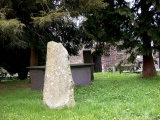
The site consists of a beautiful stone circle and a round barrow. They are located just outside a grain field just at the edge of a large forest. A small shed in just north of the barrow. The site only has small grass and some small bush so the site is easy to find.
The stone circle consists of 8 large round boulders connected with lines of smaller stones between them in ground height. The smaller stones between the larger ones can not be seen under the moss but the stones can be felt under the vegetation. Six of the stones are still standing upright while 2 have fallen over. The stones vary from 60cm to 1,3 metres in height. The stones vary from 90 to 1,2 metres wide and thick. The distance between the stones are around 4 metres and the stone circle has a diameter of around 11 metres. The stones are easy to see in the low vegetation. The owner of the farm said that a much larger stone once was in the centre of the circle but have later been removed.
10 metres north of the stone circle is a very pretty round barrow. The barrow has a ditch dug into the side but it still has a very pretty profile. The barrow is 20 metres in diameter and 2 metres in height.
You may be viewing yesterday's version of this page. To see the most up to date information please register for a free account.
")
")
")
")
")
")
")
")
")
Do not use the above information on other web sites or publications without permission of the contributor.
Click here to see more info for this site
Nearby sites
Click here to view sites on an interactive map of the areaKey: Red: member's photo, Blue: 3rd party photo, Yellow: other image, Green: no photo - please go there and take one, Grey: site destroyed
Download sites to:
KML (Google Earth)
GPX (GPS waypoints)
CSV (Garmin/Navman)
CSV (Excel)
To unlock full downloads you need to sign up as a Contributory Member. Otherwise downloads are limited to 50 sites.
Turn off the page maps and other distractions
Nearby sites listing. In the following links * = Image available
190m NNE 23° Gukil* Natural Stone / Erratic / Other Natural Feature
4.6km SSW 209° Bæljeråsen* Hillfort
5.3km S 179° Trolldansen* Stone Circle
6.8km S 170° Festningsåsen* Hillfort
12.3km SSW 207° Ospeveien* Round Barrow(s)
12.6km SW 215° Monaryggen* Barrow Cemetery
13.9km SSW 199° Bjerkelunden* Barrow Cemetery
15.0km WSW 238° Grøttvet Nordre* Stone Circle
15.5km WSW 245° Haraldstad Mound* Round Barrow(s)
15.9km WSW 239° Museumsveien* Round Barrow(s)
16.6km SW 233° Neverstien-Løken Søndre* Round Barrow(s)
16.7km WSW 243° Offeret* Stone Circle
16.8km WSW 238° Askim Fylkessykehusets Park* Barrow Cemetery
16.9km SW 235° Somerrogata-Løkentunet* Round Barrow(s)
17.0km WSW 238° Askim Folkepark Cemetery* Barrow Cemetery
18.0km S 191° Trømborg* Barrow Cemetery
18.5km W 266° Olafsrud-Slottsåsen Hillfort* Hillfort
19.3km WSW 243° Romskollen* Hillfort
20.3km W 259° Hylligraven* Passage Grave
24.3km NNW 336° Tølleren Gan* Barrow Cemetery
25.9km SSW 212° Skiptvet Church cup Mark* Carving
28.1km SSW 210° Kransrud-Borgåsen* Hillfort
28.3km SSW 197° Sæevisslottet* Hillfort
29.3km W 277° Mellegård* Barrow Cemetery
29.4km W 276° St Hanshaugen* Round Barrow(s)
View more nearby sites and additional images


 We would like to know more about this location. Please feel free to add a brief description and any relevant information in your own language.
 Wir möchten mehr über diese Stätte erfahren. Bitte zögern Sie nicht, eine kurze Beschreibung und relevante Informationen in Deutsch hinzuzufügen.
 Nous aimerions en savoir encore un peu sur les lieux. S'il vous plaît n'hesitez pas à ajouter une courte description et tous les renseignements pertinents dans votre propre langue.
 Quisieramos informarnos un poco más de las lugares. No dude en añadir una breve descripción y otros datos relevantes en su propio idioma.