 with our Megalithic Portal iPhone app")


<< Our Photo Pages >> Ffridd Can Awen Cairn - Cairn in Wales in Conwy
Submitted by TAlanJones on Saturday, 22 July 2023 Page Views: 250
Neolithic and Bronze AgeSite Name: Ffridd Can Awen CairnCountry: Wales County: Conwy Type: Cairn
Nearest Village: Pentrefoelas
Map Ref: SH8774053620
Latitude: 53.067985N Longitude: 3.676868W
Condition:
| 5 | Perfect |
| 4 | Almost Perfect |
| 3 | Reasonable but with some damage |
| 2 | Ruined but still recognisable as an ancient site |
| 1 | Pretty much destroyed, possibly visible as crop marks |
| 0 | No data. |
| -1 | Completely destroyed |
| 5 | Superb |
| 4 | Good |
| 3 | Ordinary |
| 2 | Not Good |
| 1 | Awful |
| 0 | No data. |
| 5 | Can be driven to, probably with disabled access |
| 4 | Short walk on a footpath |
| 3 | Requiring a bit more of a walk |
| 2 | A long walk |
| 1 | In the middle of nowhere, a nightmare to find |
| 0 | No data. |
| 5 | co-ordinates taken by GPS or official recorded co-ordinates |
| 4 | co-ordinates scaled from a detailed map |
| 3 | co-ordinates scaled from a bad map |
| 2 | co-ordinates of the nearest village |
| 1 | co-ordinates of the nearest town |
| 0 | no data |
Internal Links:
External Links:
")
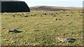
Situated within a field known as Ffridd Can Awen and lying close to the Hiraethog Trail that meanders from Pentrefoelas village towards the northern lakes of Alwen, Aled and Aled reservoir, the cairn stands out within the field as a large high clump of mixed vegetation. The cairn itself is quite small. At 3m diameter and 0.25m high it needed the vegetation overcoat to make an impression. However, there is an interesting earthwork, a linear depression leading south from the cairn site that suggests a trackway?
You may be viewing yesterday's version of this page. To see the most up to date information please register for a free account.
")
")
")
Do not use the above information on other web sites or publications without permission of the contributor.
Nearby Images from Geograph Britain and Ireland:
©2006(licence)
©2017(licence)
©2022(licence)
©2022(licence)
©2017(licence)
The above images may not be of the site on this page, they are loaded from Geograph.
Please Submit an Image of this site or go out and take one for us!
Click here to see more info for this site
Nearby sites
Key: Red: member's photo, Blue: 3rd party photo, Yellow: other image, Green: no photo - please go there and take one, Grey: site destroyed
Download sites to:
KML (Google Earth)
GPX (GPS waypoints)
CSV (Garmin/Navman)
CSV (Excel)
To unlock full downloads you need to sign up as a Contributory Member. Otherwise downloads are limited to 50 sites.
Turn off the page maps and other distractions
Nearby sites listing. In the following links * = Image available
184m SSE 156° Hafod y Garreg Row* Stone Row / Alignment (SH87815345)
184m SE 138° Ffridd Can Awen Cists* Cist (SH8786053480)
242m SE 127° Hafod Y Carreg Cairn Field* Barrow Cemetery (SH8793053470)
260m S 181° Hafod Y Garreg Earthworks and Cairns* Barrow Cemetery (SH8773053360)
272m SE 143° Hafod Y Garreg Cist* Cist (SH8790053400)
348m NE 38° Cefnen Wen Cairn Field* Barrow Cemetery (SH8796053890)
697m NE 37° Cefnen Wen Cairn and Cist* Cairn (SH8817054170)
735m NE 41° Cefnen Wen Cairn East* Cairn (SH8824054160)
793m E 82° Hafod y Dre* Stone Row / Alignment (SH88535371)
1.3km NE 36° Bryniau Duon Cairn on Hiraethog Trail* Cairn (SH8855054670)
1.4km SW 216° Carreg Nant Y Foel* Natural Stone / Erratic / Other Natural Feature (SH8690152540)
1.5km NNE 31° Moel Rhiwlug Recumbent* Natural Stone / Erratic / Other Natural Feature (SH8855954892)
1.6km NNE 18° Moel Rhiwlug Cairn 2* Cairn (SH88295515)
1.9km NNE 20° Moel Rhiwlug Cairn 1* Cairn (SH88445538)
2.0km WNW 300° Maes Merddyn Ring Cairn 1* Ring Cairn (SH8600054660)
2.0km SSW 194° Lon Mynydd Hiraethog* Ancient Trackway (SH8719051650)
2.1km WNW 298° Maes Merddyn Ring Cairn 2* Ring Cairn (SH85925463)
2.2km NNE 33° Pen Yr Orsedd Ring Cairn* Ring Cairn (SH8901055460)
2.6km E 80° Bwlch y Garnedd Hut Circle* Ancient Village or Settlement (SH90305401)
2.8km ENE 77° Bwlch y Garnedd Menhir Standing Stone (Menhir) (SH9045254194)
2.8km ENE 77° Lon Bwlch y Garnedd standing stones* Standing Stones (SH9046154197)
3.1km ENE 72° Bwlch y Garnedd Cairn 3 Cairn (SH90695450)
3.3km SSE 148° Carreg Nanw* Modern Stone Circle etc (SH8940550794)
3.3km ENE 65° Bwlch y Garnedd Round Cairn* Round Cairn (SH90755494)
3.8km NW 310° Bryn-Cyplau Cairn Circle East Ring Cairn (SH8489756103)
View more nearby sites and additional images


 We would like to know more about this location. Please feel free to add a brief description and any relevant information in your own language.
 Wir möchten mehr über diese Stätte erfahren. Bitte zögern Sie nicht, eine kurze Beschreibung und relevante Informationen in Deutsch hinzuzufügen.
 Nous aimerions en savoir encore un peu sur les lieux. S'il vous plaît n'hesitez pas à ajouter une courte description et tous les renseignements pertinents dans votre propre langue.
 Quisieramos informarnos un poco más de las lugares. No dude en añadir una breve descripción y otros datos relevantes en su propio idioma.