


<< Our Photo Pages >> Law Knowe - Cairn in Scotland in South Lanarkshire
Submitted by markj99 on Wednesday, 03 May 2023 Page Views: 386
Neolithic and Bronze AgeSite Name: Law KnoweCountry: Scotland County: South Lanarkshire Type: Cairn
Nearest Town: East Kilbride
Map Ref: NS63175613
Latitude: 55.779071N Longitude: 4.18319W
Condition:
| 5 | Perfect |
| 4 | Almost Perfect |
| 3 | Reasonable but with some damage |
| 2 | Ruined but still recognisable as an ancient site |
| 1 | Pretty much destroyed, possibly visible as crop marks |
| 0 | No data. |
| -1 | Completely destroyed |
| 5 | Superb |
| 4 | Good |
| 3 | Ordinary |
| 2 | Not Good |
| 1 | Awful |
| 0 | No data. |
| 5 | Can be driven to, probably with disabled access |
| 4 | Short walk on a footpath |
| 3 | Requiring a bit more of a walk |
| 2 | A long walk |
| 1 | In the middle of nowhere, a nightmare to find |
| 0 | No data. |
| 5 | co-ordinates taken by GPS or official recorded co-ordinates |
| 4 | co-ordinates scaled from a detailed map |
| 3 | co-ordinates scaled from a bad map |
| 2 | co-ordinates of the nearest village |
| 1 | co-ordinates of the nearest town |
| 0 | no data |
Internal Links:
External Links:
I have visited· I would like to visit
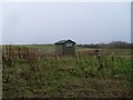
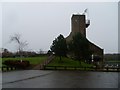
markj99 visited on 2nd May 2023 The location of Lab Knowe has been preserved for future antiquarians, however the grass mound with a modern stone marker cairn and information plaque is scant compensation for the destruction of an ancient cairn.
")
Law Knowe was the site of a cairn on a natural knoll on the N fringe of East Kilbride in South Lanarkshire. The cairn measured 8 or 10 yards and had a kerb of large flagstones according to Canmore ID 44899. Canmore states that a large part of the cairn was robbed by the end of the 18th Century and no traces of the cairn remained in 1955.
A Playsport golf course has been constructed on the site of the cairn. The location, in the SW corner of the golf course, has a Marker Cairn with an information plaque constructed on top of Law Knowe.
You may be viewing yesterday's version of this page. To see the most up to date information please register for a free account.
")
")
")
")
Do not use the above information on other web sites or publications without permission of the contributor.
Nearby Images from Geograph Britain and Ireland:
©2010(licence)
©2010(licence)
©2010(licence)
©2010(licence)
©2010(licence)
The above images may not be of the site on this page, they are loaded from Geograph.
Please Submit an Image of this site or go out and take one for us!
Click here to see more info for this site
Nearby sites
Key: Red: member's photo, Blue: 3rd party photo, Yellow: other image, Green: no photo - please go there and take one, Grey: site destroyed
Download sites to:
KML (Google Earth)
GPX (GPS waypoints)
CSV (Garmin/Navman)
CSV (Excel)
To unlock full downloads you need to sign up as a Contributory Member. Otherwise downloads are limited to 50 sites.
Turn off the page maps and other distractions
Nearby sites listing. In the following links * = Image available
5.5km N 360° Hamilton Farm (Cambuslang) Cairn (NS633616)
6.3km NE 38° Bargeddie Food Vessel Cemetery Barrow Cemetery (NS672610)
8.5km W 279° Rouken Glen Park* Rock Art (NS54795771)
8.5km NNW 336° Arns Well (Glasgow) Holy Well or Sacred Spring (NS59966406)
8.6km SE 143° Shawton (Chapeltown) Standing Stone (Menhir) (NS68124906)
9.2km NNW 338° St Mungo's Well (Dovehill) Holy Well or Sacred Spring (NS5998464788)
9.5km NNW 335° Stock Well (Glasgow) Holy Well or Sacred Spring (NS594649)
9.6km NNW 341° Lady Well (Glasgow)* Holy Well or Sacred Spring (NS6037765327)
9.6km NNW 332° St Thenew's Well (Glasgow) Holy Well or Sacred Spring (NS589648)
9.9km NNW 342° St Mungo's Well (Glasgow)* Holy Well or Sacred Spring (NS604656)
9.9km NNW 341° St Mungo's Well (Glasgow Cathedral)* Holy Well or Sacred Spring (NS60256557)
10.1km SW 231° West Revoch Stone Row / Alignment (NS55104995)
10.2km WNW 301° Pollok House Barrow* Round Barrow(s) (NS54606164)
10.2km WNW 295° Boydstone Road (Eastwood) Standing Stone (Menhir) (NS541608)
10.7km NNW 341° Sighthill Park Stone Circle* Modern Stone Circle etc (NS5992266373)
11.2km SW 235° Ballageich Hill* Cairn (NS53745005)
12.0km NW 326° Kelvingrove Museum and Art Gallery* Museum (NS5676166302)
12.2km NNW 328° Hunterian Museum* Museum (NS56906667)
12.5km NW 320° The Govan Stones* Museum (NS55346590)
12.6km SSE 148° Three Stanes (Strathaven) Standing Stones (NS69574524)
13.0km W 267° Duncarnock Hillfort Hillfort (NS50105590)
13.8km SSE 147° St Anne's Well (Strathaven) Holy Well or Sacred Spring (NS70394438)
15.6km WSW 258° Covenanter's Stone* Stone Circle (NS47735333)
16.3km WSW 257° Moyne Moor* Cairn (NS471529)
16.5km WNW 296° Barochan Cross* Ancient Cross (NS48556395)
View more nearby sites and additional images


 We would like to know more about this location. Please feel free to add a brief description and any relevant information in your own language.
 Wir möchten mehr über diese Stätte erfahren. Bitte zögern Sie nicht, eine kurze Beschreibung und relevante Informationen in Deutsch hinzuzufügen.
 Nous aimerions en savoir encore un peu sur les lieux. S'il vous plaît n'hesitez pas à ajouter une courte description et tous les renseignements pertinents dans votre propre langue.
 Quisieramos informarnos un poco más de las lugares. No dude en añadir una breve descripción y otros datos relevantes en su propio idioma.