

<< Our Photo Pages >> Gyldenså 1 Skåltegn - Rock Art in Denmark in Bornholm
Submitted by Boeddel on Monday, 10 April 2023 Page Views: 403
Rock ArtSite Name: Gyldenså 1 SkåltegnCountry: Denmark County: Bornholm Type: Rock Art
Nearest Town: Svaneke
Latitude: 55.135319N Longitude: 15.067573E
Condition:
| 5 | Perfect |
| 4 | Almost Perfect |
| 3 | Reasonable but with some damage |
| 2 | Ruined but still recognisable as an ancient site |
| 1 | Pretty much destroyed, possibly visible as crop marks |
| 0 | No data. |
| -1 | Completely destroyed |
| 5 | Superb |
| 4 | Good |
| 3 | Ordinary |
| 2 | Not Good |
| 1 | Awful |
| 0 | No data. |
| 5 | Can be driven to, probably with disabled access |
| 4 | Short walk on a footpath |
| 3 | Requiring a bit more of a walk |
| 2 | A long walk |
| 1 | In the middle of nowhere, a nightmare to find |
| 0 | No data. |
| 5 | co-ordinates taken by GPS or official recorded co-ordinates |
| 4 | co-ordinates scaled from a detailed map |
| 3 | co-ordinates scaled from a bad map |
| 2 | co-ordinates of the nearest village |
| 1 | co-ordinates of the nearest town |
| 0 | no data |
Internal Links:
External Links:
I have visited· I would like to visit
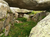
Boeddel visited on 5th Apr 2023 - their rating: Cond: 3 Amb: 5 Access: 4 It is not far to walk, but there is no path leading to the stone, so in the summer months it is probably not very pleasant to go there due to the vegetation. Especially because Bornholm has quite a lot of ticks and the island is considered a risk area.
")
A stone split in three parts with cup-marks on all three parts of the stone.
You may be viewing yesterday's version of this page. To see the most up to date information please register for a free account.
")
")
")
")
Do not use the above information on other web sites or publications without permission of the contributor.
Nearby Images from Flickr


The above images may not be of the site on this page, but were taken nearby. They are loaded from Flickr so please click on them for image credits.
Click here to see more info for this site
Nearby sites
Click here to view sites on an interactive map of the areaKey: Red: member's photo, Blue: 3rd party photo, Yellow: other image, Green: no photo - please go there and take one, Grey: site destroyed
Download sites to:
KML (Google Earth)
GPX (GPS waypoints)
CSV (Garmin/Navman)
CSV (Excel)
To unlock full downloads you need to sign up as a Contributory Member. Otherwise downloads are limited to 50 sites.
Turn off the page maps and other distractions
Nearby sites listing. In the following links * = Image available
183m NNE 13° Louisenlund Grove* Standing Stones
1.0km NNE 14° Stenshøj Skåltegn* Rock Art
1.1km NNE 14° Lysepers Høj* Round Barrow(s)
1.2km ENE 73° Kurehøj Svaneke* Round Barrow(s)
1.5km WSW 251° Østermariestenen 4* Sculptured Stone
1.6km N 349° Bøgehøj Rundhøj* Round Barrow(s)
1.7km NE 50° Skottehjem Rundhøj* Round Barrow(s)
2.1km NNE 32° Bølshavnstenen* Modern Stone Circle etc
2.1km NNE 32° Bølshavn Gravrøse* Cairn
2.2km NE 45° Hellig Kvinde* Standing Stones
2.4km NE 52° Styrmandshjem Bautasten* Standing Stone (Menhir)
2.6km SSE 168° Rømersminde Skåltegn* Rock Art
2.6km ENE 58° Listed væltet Bautasten* Standing Stone (Menhir)
2.7km ENE 67° Lillehøj Listed* Round Barrow(s)
2.9km ESE 114° Højevejen Kanonhøjen* Round Barrow(s)
2.9km ESE 118° Gaia + Blåfuglen* Rock Art
3.0km ESE 115° Højene Modern Stone Maze* Turf Maze
3.0km ESE 106° Højevejen Bavnehøj* Round Barrow(s)
3.1km ESE 108° Højevejen Sønderhøj* Round Barrow(s)
3.2km ESE 121° Grydehøj Rundhøj* Round Barrow(s)
3.3km W 275° Østermariestenen 5* Sculptured Stone
3.3km W 275° Østermariestenen 6* Sculptured Stone
3.3km W 275° Østermariestenen 3* Sculptured Stone
3.3km W 275° Østermariestenen 2* Sculptured Stone
3.4km ENE 76° Listed Bautasten* Standing Stones
View more nearby sites and additional images


 We would like to know more about this location. Please feel free to add a brief description and any relevant information in your own language.
 Wir möchten mehr über diese Stätte erfahren. Bitte zögern Sie nicht, eine kurze Beschreibung und relevante Informationen in Deutsch hinzuzufügen.
 Nous aimerions en savoir encore un peu sur les lieux. S'il vous plaît n'hesitez pas à ajouter une courte description et tous les renseignements pertinents dans votre propre langue.
 Quisieramos informarnos un poco más de las lugares. No dude en añadir una breve descripción y otros datos relevantes en su propio idioma.