


<< Our Photo Pages >> Stony Rigg RB1 (Goathland Moor) - Round Barrow(s) in England in Yorkshire (North)
Submitted by johndhunter on Tuesday, 13 September 2022 Page Views: 301
Neolithic and Bronze AgeSite Name: Stony Rigg RB1 (Goathland Moor)Country: England County: Yorkshire (North) Type: Round Barrow(s)
Nearest Town: Whitby Nearest Village: Goathland
Map Ref: NZ8395703441
Latitude: 54.419489N Longitude: 0.70765W
Condition:
| 5 | Perfect |
| 4 | Almost Perfect |
| 3 | Reasonable but with some damage |
| 2 | Ruined but still recognisable as an ancient site |
| 1 | Pretty much destroyed, possibly visible as crop marks |
| 0 | No data. |
| -1 | Completely destroyed |
| 5 | Superb |
| 4 | Good |
| 3 | Ordinary |
| 2 | Not Good |
| 1 | Awful |
| 0 | No data. |
| 5 | Can be driven to, probably with disabled access |
| 4 | Short walk on a footpath |
| 3 | Requiring a bit more of a walk |
| 2 | A long walk |
| 1 | In the middle of nowhere, a nightmare to find |
| 0 | No data. |
| 5 | co-ordinates taken by GPS or official recorded co-ordinates |
| 4 | co-ordinates scaled from a detailed map |
| 3 | co-ordinates scaled from a bad map |
| 2 | co-ordinates of the nearest village |
| 1 | co-ordinates of the nearest town |
| 0 | no data |
Internal Links:
External Links:
 (PID:247481)")
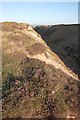
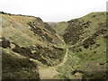
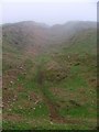
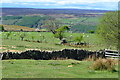
A bronze age round barrow at the northern edge of a line of whinstone quarries on Stony Rigg, with extensive views over the Esk Valley
Whilst the barrow protrudes further to the north than the rest of the spoil which runs along the northern edge of the quarries, at first glance it still appears to be part of the spoil. I doubt the casual observer would notice any difference just walking along the ridge. However on closer inspection with coordinates and information provided by Historic Englands LIST ENTRY 1021300 one can clearly see it for what it is. That is, as the list entry describes ‘a well-defined sub-circular mound constructed from earth and stone, which measures up to 18m in diameter and stands up to 1.5m high. The surface of the mound is irregular because of burrowing by rabbits.’ Also it does not appear to have been excavated in the past.
As it appeared initially (to me) to be part of the spoil, it got me thinking how Historic England knew about it in the first place and the reason no doubt will be the fact that it is clearly shown on the 1853 OS map before quarrying began. See HERE, when the map opens, zoom in extreme right, centre and just below where it says Stony Rigg you will see the tumulus. I also note that later OS maps do not identify this as a tumulus and that it it is in fact shown on the maps as part of the quarry spoil. As an example see this 1916 OS MAP, when the map opens, zoom in extreme right bottom corner and just to the left of where it says Goathland Whinstone Quarries, you will see what I mean. It is still shown similarly on the present day OS map.
‘HERR’ also has information on this barrow at MONUMENT 29427
You may be viewing yesterday's version of this page. To see the most up to date information please register for a free account.
 (PID:247478)")
Do not use the above information on other web sites or publications without permission of the contributor.
Nearby Images from Geograph Britain and Ireland:
©2013(licence)
©2022(licence)
©2013(licence)
©2006(licence)
©2017(licence)
The above images may not be of the site on this page, they are loaded from Geograph.
Please Submit an Image of this site or go out and take one for us!
Click here to see more info for this site
Nearby sites
Key: Red: member's photo, Blue: 3rd party photo, Yellow: other image, Green: no photo - please go there and take one, Grey: site destroyed
Download sites to:
KML (Google Earth)
GPX (GPS waypoints)
CSV (Garmin/Navman)
CSV (Excel)
To unlock full downloads you need to sign up as a Contributory Member. Otherwise downloads are limited to 50 sites.
Turn off the page maps and other distractions
Nearby sites listing. In the following links * = Image available
988m SW 234° Allan Tofts 9* Rock Art (NZ8316902842)
1000m WSW 248° Allan Tofts 2d* Rock Art (NZ8303503047)
1.0km WSW 250° Allan Tofts 2b* Rock Art (NZ8300503083)
1.0km WSW 249° Allan Tofts 2c* Rock Art (NZ8300503059)
1.1km WSW 247° Allan Tofts 2e* Rock Art (NZ8298903016)
1.1km WSW 248° Allan Tofts 2g* Rock Art (NZ8294903016)
1.2km WSW 237° Allan Tofts 7* Rock Art (NZ8294502747)
1.2km WSW 247° Allan Tofts 4b* Rock Art (NZ8283002928)
1.4km ESE 117° Sil Howe* Round Barrow(s) (NZ8519002830)
1.4km E 92° Breckon Howe (Sleights Moor)* Round Barrow(s) (NZ8537603406)
1.4km WSW 245° Allan Tofts 5c* Rock Art (NZ8265502816)
1.5km NNE 23° Low Bridestones (Yorks)* Stone Row / Alignment (NZ8454104859)
1.6km NE 42° High Bridestones (Yorks)* Stone Circle (NZ8499704629)
1.7km E 82° Pen Howe (Sleights Moor)* Round Barrow(s) (NZ8563903722)
1.8km SW 233° Pennock Puzzle Stone* Carving (NZ8252902337)
1.9km NE 54° Flat Howe (Sleights Moor)* Round Barrow(s) (NZ85510461)
2.3km ESE 118° Flass Brow Round Barrow* Round Barrow(s) (NZ860024)
2.4km ESE 109° Flass Brow Marker Stones* Marker Stone (NZ8620802708)
2.9km E 89° Greenland's Howe (Sleights Moor)* Cist (NZ8688103552)
3.2km ESE 118° Robbed Howe* Round Barrow(s) (NZ8685001958)
3.6km WSW 256° In Moor.* Cairn (NZ805025)
3.6km SW 215° Hunt House Road Standing Stone* Marker Stone (NZ8192900430)
4.2km SSW 201° Two Howes Rigg* Round Barrow(s) (SE8252899444)
4.3km SE 126° Foster Howes* Round Barrow(s) (NZ8744800991)
4.3km ESE 117° York Cross (Sneaton High Moor)* Ancient Cross (NZ8785901524)
View more nearby sites and additional images


 We would like to know more about this location. Please feel free to add a brief description and any relevant information in your own language.
 Wir möchten mehr über diese Stätte erfahren. Bitte zögern Sie nicht, eine kurze Beschreibung und relevante Informationen in Deutsch hinzuzufügen.
 Nous aimerions en savoir encore un peu sur les lieux. S'il vous plaît n'hesitez pas à ajouter une courte description et tous les renseignements pertinents dans votre propre langue.
 Quisieramos informarnos un poco más de las lugares. No dude en añadir una breve descripción y otros datos relevantes en su propio idioma.