

<< Image Pages >> Brands Hill - Ancient Village or Settlement in England in Northumberland
Submitted by Zooks777 on Friday, 03 September 2021 Page Views: 675
Multi-periodSite Name: Brands HillCountry: England County: Northumberland Type: Ancient Village or Settlement
Nearest Town: Wooler Nearest Village: North Middleton
Map Ref: NT98162406
Latitude: 55.510302N Longitude: 2.03069W
Condition:
| 5 | Perfect |
| 4 | Almost Perfect |
| 3 | Reasonable but with some damage |
| 2 | Ruined but still recognisable as an ancient site |
| 1 | Pretty much destroyed, possibly visible as crop marks |
| 0 | No data. |
| -1 | Completely destroyed |
| 5 | Superb |
| 4 | Good |
| 3 | Ordinary |
| 2 | Not Good |
| 1 | Awful |
| 0 | No data. |
| 5 | Can be driven to, probably with disabled access |
| 4 | Short walk on a footpath |
| 3 | Requiring a bit more of a walk |
| 2 | A long walk |
| 1 | In the middle of nowhere, a nightmare to find |
| 0 | No data. |
| 5 | co-ordinates taken by GPS or official recorded co-ordinates |
| 4 | co-ordinates scaled from a detailed map |
| 3 | co-ordinates scaled from a bad map |
| 2 | co-ordinates of the nearest village |
| 1 | co-ordinates of the nearest town |
| 0 | no data |
Internal Links:
External Links:
")
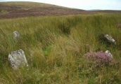
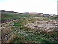
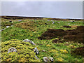
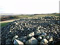
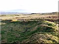
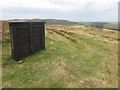
Closely-spaced, enclosed ‘homesteads’ and ‘settlements’ with associated remnants of field systems, covering an area of 2 km N-S x 0.8 km E-W. Similar to Iron Age/Romano-British (?) enclosures in Lunesdale and central Cumbria (egs Leck Hall and Ewe Close). Some, but not all recorded on OS maps. Associated medieval (?) ridge & furrow patterns. Abundant other ‘lumps and bumps’ (possibly field-clearance cairns) and small circular features.
Several individual sites here are described in detail at https://ancientmonuments.uk/historic-county/northumberland, with various age suggestions: prehistoric; Bronze Age; Roman period native enclosed settlement etc..
You may be viewing yesterday's version of this page. To see the most up to date information please register for a free account.
")
Do not use the above information on other web sites or publications without permission of the contributor.
Nearby Images from Geograph Britain and Ireland:
©2012(licence)
©2024(licence)
©2012(licence)
©2012(licence)
©2020(licence)
The above images may not be of the site on this page, they are loaded from Geograph.
Please Submit an Image of this site or go out and take one for us!
Click here to see more info for this site
Nearby sites
Key: Red: member's photo, Blue: 3rd party photo, Yellow: other image, Green: no photo - please go there and take one, Grey: site destroyed
Download sites to:
KML (Google Earth)
GPX (GPS waypoints)
CSV (Garmin/Navman)
CSV (Excel)
To unlock full downloads you need to sign up as a Contributory Member. Otherwise downloads are limited to 50 sites.
Turn off the page maps and other distractions
Nearby sites listing. In the following links * = Image available
1.3km NW 311° Carey Burn (Harthope Valley)* Ancient Village or Settlement (NT97172491)
1.3km SE 143° The Ringles* Hillfort (NT98982299)
1.5km SE 143° South Ringles* Ancient Village or Settlement (NT99072285)
1.8km SSE 151° South Middleton Moor* Rock Art (NT9901722519)
1.9km SSE 151° South Middleton Cairn* Cairn (NT99092241)
2.4km NW 325° Hart Heugh* Stone Circle (NT968260)
2.5km ESE 113° Foxes Knoll* Hillfort (NU00492308)
2.7km SE 143° Middleton Dean* Promontory Fort / Cliff Castle (NT99782194)
2.7km SSE 147° Heddon Hill* Rock Art (NT9964621794)
3.0km SW 232° Langleeford N01 Rock Art (NT9580222191)
3.0km N 8° Maiden Well (Kettle Hill)* Holy Well or Sacred Spring (NT9856427053)
3.1km SW 231° Langleeford 1 Rock Art (NT9577522147)
3.1km N 9° Maiden Well (Northumberland) Holy Well or Sacred Spring (NT9866427082)
3.3km N 5° The Kettles (Wooler)* Hillfort (NT98472730)
3.5km ENE 64° Clover Bank (Lilburn Hill Farm) Rock Art (NU01312556)
3.5km ENE 64° Lilburn Rock Art* Rock Art (NU013256)
3.7km SSW 196° Threestoneburn* Stone Circle (NT9714020502)
3.8km N 0° Green Castle Ringwork* Misc. Earthwork (NT9818027853)
3.8km N 0° Green Castle 2 Rock Art (NT9818227887)
3.9km N 355° Green Castle 1 Rock Art (NT9784227949)
3.9km NE 44° Coldmartin Tower Rock Art (NU0090026910)
4.2km NNE 16° Wooler Cottage Wall Rock Art (NT993281)
4.4km N 4° Highburn House 1 Rock Art (NT9849128424)
4.4km NNW 341° Humbleton Hill* Hillfort (NT9670628252)
4.6km N 10° Tankerville Arms Hotel Cist* Cist (NT9894328604)
View more nearby sites and additional images


 We would like to know more about this location. Please feel free to add a brief description and any relevant information in your own language.
 Wir möchten mehr über diese Stätte erfahren. Bitte zögern Sie nicht, eine kurze Beschreibung und relevante Informationen in Deutsch hinzuzufügen.
 Nous aimerions en savoir encore un peu sur les lieux. S'il vous plaît n'hesitez pas à ajouter une courte description et tous les renseignements pertinents dans votre propre langue.
 Quisieramos informarnos un poco más de las lugares. No dude en añadir una breve descripción y otros datos relevantes en su propio idioma.