

<< Our Photo Pages >> Cors Y Garnedd Round Barrow - Round Barrow(s) in Wales in Gwynedd
Submitted by TAlanJones on Sunday, 11 October 2020 Page Views: 926
Neolithic and Bronze AgeSite Name: Cors Y Garnedd Round Barrow Alternative Name: Cors Y Garnedd TumulusCountry: Wales County: Gwynedd Type: Round Barrow(s)
Nearest Town: Dolgellau Nearest Village: Llanfachreth
Map Ref: SH768242
Latitude: 52.801244N Longitude: 3.828872W
Condition:
| 5 | Perfect |
| 4 | Almost Perfect |
| 3 | Reasonable but with some damage |
| 2 | Ruined but still recognisable as an ancient site |
| 1 | Pretty much destroyed, possibly visible as crop marks |
| 0 | No data. |
| -1 | Completely destroyed |
| 5 | Superb |
| 4 | Good |
| 3 | Ordinary |
| 2 | Not Good |
| 1 | Awful |
| 0 | No data. |
| 5 | Can be driven to, probably with disabled access |
| 4 | Short walk on a footpath |
| 3 | Requiring a bit more of a walk |
| 2 | A long walk |
| 1 | In the middle of nowhere, a nightmare to find |
| 0 | No data. |
| 5 | co-ordinates taken by GPS or official recorded co-ordinates |
| 4 | co-ordinates scaled from a detailed map |
| 3 | co-ordinates scaled from a bad map |
| 2 | co-ordinates of the nearest village |
| 1 | co-ordinates of the nearest town |
| 0 | no data |
Internal Links:
External Links:
")
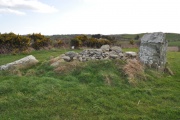
The monument is a grassy mound that is 7m in diameter at a height of 1.45m. The barrow has not been excavated.
Approximately 25m north of the barrow is a large cairn. It may be a clearance cairn but it appears to have been excavated in the centre. A large tree has fallen onto it.
On this occasion there was a bull in the field so a little caution was necessary.
You may be viewing yesterday's version of this page. To see the most up to date information please register for a free account.
")
")
")
")
")
")
Do not use the above information on other web sites or publications without permission of the contributor.
Click here to see more info for this site
Nearby sites
Key: Red: member's photo, Blue: 3rd party photo, Yellow: other image, Green: no photo - please go there and take one, Grey: site destroyed
Download sites to:
KML (Google Earth)
GPX (GPS waypoints)
CSV (Garmin/Navman)
CSV (Excel)
To unlock full downloads you need to sign up as a Contributory Member. Otherwise downloads are limited to 50 sites.
Turn off the page maps and other distractions
Nearby sites listing. In the following links * = Image available
1.8km SW 236° Cairn east of Mynydd Ty Isaf* Cairn (SH7529723251)
1.9km WSW 239° Mynydd Ty Isaf Cairn Cemetery* Barrow Cemetery (SH7515023273)
2.0km WSW 238° Ring Cairn SW of Mynydd Ty Isaf* Ring Cairn (SH7511123193)
2.0km WSW 241° Cairn West of Mynydd Ty Isaf* Cairn (SH7503023291)
2.2km SSW 199° Y Garreg Fawr (the Great Stone)* Modern Stone Circle etc (SH760221)
2.4km SW 223° Ffynnon-Y-Capel Holy Well or Sacred Spring (SH75102248)
2.5km SSE 165° Hill Fort West of Ystum Gwadnaeth* Hillfort (SH774218)
3.2km SW 223° Tyddyn Bach Round Barrow* Round Barrow(s) (SH74572196)
3.7km SSW 209° Moel Offrwm* Hillfort (SH749210)
4.0km WSW 250° Carreg Coed Y Brenin* Modern Stone Circle etc (SH730229)
4.2km SSW 209° Caer Isaf Moel-Offrwm* Hillfort (SH747206)
4.7km W 262° Berth Llwyd Enclosure* Ancient Village or Settlement (SH7210023670)
4.7km WSW 246° Tyddyn Bach Stone* Standing Stone (Menhir) (SH7241022420)
4.7km W 261° Berth Llwyd Hut Circle* Ancient Village or Settlement (SH7210023550)
4.8km W 263° Berth Llwyd Cairn Cemetery* Barrow Cemetery (SH7206023700)
5.0km WSW 255° Dolmelynllyn Estate Platform House* Ancient Village or Settlement (SH7197223010)
5.0km N 10° Rhiw Felen Hut Circle* Ancient Village or Settlement (SH778291)
5.1km WSW 253° Dolmelynllyn Estate Hut Circle* Ancient Village or Settlement (SH7187022823)
5.2km WNW 283° Craig Y Ganllwyd* Cairn (SH718255)
5.2km SW 221° Foel Faner* Hillfort (SH733204)
5.3km WSW 244° Cefn Coch Cairn and Cist* Cairn (SH720220)
5.8km E 94° Dolddeuli* Standing Stone (Menhir) (SH826236)
6.0km NW 309° Bwlch Y Ffordd Homestead* Ancient Village or Settlement (SH722281)
6.3km SW 219° Coed Pen Y Bryn Defended Settlement* Hillfort (SH727194)
6.4km S 172° Y Foel Caerynwch Cairn* Cairn (SH775178)
View more nearby sites and additional images


 We would like to know more about this location. Please feel free to add a brief description and any relevant information in your own language.
 Wir möchten mehr über diese Stätte erfahren. Bitte zögern Sie nicht, eine kurze Beschreibung und relevante Informationen in Deutsch hinzuzufügen.
 Nous aimerions en savoir encore un peu sur les lieux. S'il vous plaît n'hesitez pas à ajouter une courte description et tous les renseignements pertinents dans votre propre langue.
 Quisieramos informarnos un poco más de las lugares. No dude en añadir una breve descripción y otros datos relevantes en su propio idioma.