

<< Our Photo Pages >> Gullhaugen-Alstadhaug - Round Barrow(s) in Norway in Telemark
Submitted by kenntha88 on Friday, 28 August 2020 Page Views: 375
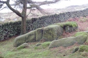
Iron Age and Later PrehistorySite Name: Gullhaugen-AlstadhaugCountry: Norway Fylke: Telemark Type: Round Barrow(s)
Nearest Town: Skien Nearest Village: Gvarv
Latitude: 59.423099N Longitude: 9.139114E
Condition:
| 5 | Perfect |
| 4 | Almost Perfect |
| 3 | Reasonable but with some damage |
| 2 | Ruined but still recognisable as an ancient site |
| 1 | Pretty much destroyed, possibly visible as crop marks |
| 0 | No data. |
| -1 | Completely destroyed |
| 5 | Superb |
| 4 | Good |
| 3 | Ordinary |
| 2 | Not Good |
| 1 | Awful |
| 0 | No data. |
| 5 | Can be driven to, probably with disabled access |
| 4 | Short walk on a footpath |
| 3 | Requiring a bit more of a walk |
| 2 | A long walk |
| 1 | In the middle of nowhere, a nightmare to find |
| 0 | No data. |
| 5 | co-ordinates taken by GPS or official recorded co-ordinates |
| 4 | co-ordinates scaled from a detailed map |
| 3 | co-ordinates scaled from a bad map |
| 2 | co-ordinates of the nearest village |
| 1 | co-ordinates of the nearest town |
| 0 | no data |
Internal Links:
External Links:
")
You may be viewing yesterday's version of this page. To see the most up to date information please register for a free account.
")
Do not use the above information on other web sites or publications without permission of the contributor.
Nearby Images from Flickr


The above images may not be of the site on this page, but were taken nearby. They are loaded from Flickr so please click on them for image credits.
Click here to see more info for this site
Nearby sites
Click here to view sites on an interactive map of the areaKey: Red: member's photo, Blue: 3rd party photo, Yellow: other image, Green: no photo - please go there and take one, Grey: site destroyed
Download sites to:
KML (Google Earth)
GPX (GPS waypoints)
CSV (Garmin/Navman)
CSV (Excel)
To unlock full downloads you need to sign up as a Contributory Member. Otherwise downloads are limited to 50 sites.
Turn off the page maps and other distractions
Nearby sites listing. In the following links * = Image available
1.8km SSE 163° Leikvang* Barrow Cemetery
1.9km WNW 284° Gåra Gravfelt* Barrow Cemetery
2.1km W 267° Steinmerra* Rock Art
3.3km WSW 250° Grivi* Round Barrow(s)
3.6km SSE 165° Håtveit Barrows* Round Barrow(s)
5.2km SE 140° Nesbyen-Tinghaug* Modern Stone Circle etc
6.4km W 281° Breskelivegen* Round Barrow(s)
6.9km W 279° Breskelimogane* Barrow Cemetery
7.4km SE 140° Neshaugen* Round Barrow(s)
8.0km WSW 255° Trellsborg hillfort* Hillfort
9.6km E 94° Briskemoen* Barrow Cemetery
16.9km NNE 12° Semhaugen* Round Barrow(s)
17.5km S 182° Tyri-Vedlandsvegen* Barrow Cemetery
29.1km WNW 283° Kristofferhaugen* Round Barrow(s)
30.0km WNW 282° Fesjåplassen* Round Barrow(s)
30.8km SE 125° Nøklegård* Round Barrow(s)
31.0km SE 127° Nord-Tufte-Foss* Barrow Cemetery
31.5km SE 128° Fossum Helleristninger* Rock Art
31.6km SE 127° Sør-Tufte* Barrow Cemetery
31.8km SE 127° Luksefjellvegen* Round Barrow(s)
32.2km SE 127° Berland Barrow Cemetery* Barrow Cemetery
34.5km SE 129° Gjerpen Skole* Rock Art
35.3km SE 134° Kjempa Hillfort* Hillfort
35.5km ESE 115° Siljuhaugen* Round Barrow(s)
35.8km NE 56° Knatten* Barrow Cemetery
View more nearby sites and additional images


 We would like to know more about this location. Please feel free to add a brief description and any relevant information in your own language.
 Wir möchten mehr über diese Stätte erfahren. Bitte zögern Sie nicht, eine kurze Beschreibung und relevante Informationen in Deutsch hinzuzufügen.
 Nous aimerions en savoir encore un peu sur les lieux. S'il vous plaît n'hesitez pas à ajouter une courte description et tous les renseignements pertinents dans votre propre langue.
 Quisieramos informarnos un poco más de las lugares. No dude en añadir una breve descripción y otros datos relevantes en su propio idioma.