


<< Our Photo Pages >> Knocklane - Promontory Fort / Cliff Castle in Ireland (Republic of) in Co. Sligo
Submitted by h_fenton on Sunday, 29 March 2020 Page Views: 3593
Iron Age and Later PrehistorySite Name: KnocklaneCountry: Ireland (Republic of) County: Co. Sligo Type: Promontory Fort / Cliff Castle
Nearest Town: Sligo Nearest Village: Ballineden
Latitude: 54.349000N Longitude: 8.679W
Condition:
| 5 | Perfect |
| 4 | Almost Perfect |
| 3 | Reasonable but with some damage |
| 2 | Ruined but still recognisable as an ancient site |
| 1 | Pretty much destroyed, possibly visible as crop marks |
| 0 | No data. |
| -1 | Completely destroyed |
| 5 | Superb |
| 4 | Good |
| 3 | Ordinary |
| 2 | Not Good |
| 1 | Awful |
| 0 | No data. |
| 5 | Can be driven to, probably with disabled access |
| 4 | Short walk on a footpath |
| 3 | Requiring a bit more of a walk |
| 2 | A long walk |
| 1 | In the middle of nowhere, a nightmare to find |
| 0 | No data. |
| 5 | co-ordinates taken by GPS or official recorded co-ordinates |
| 4 | co-ordinates scaled from a detailed map |
| 3 | co-ordinates scaled from a bad map |
| 2 | co-ordinates of the nearest village |
| 1 | co-ordinates of the nearest town |
| 0 | no data |
Internal Links:
External Links:
I have visited· I would like to visit
SolarMegalith would like to visit
")
In the late (and not early) 19th century a series of buildings are shown within the main enclosure, these are names on the 25" map as being Knocklane Castle, in subsequent times the castle structure has been comprehensively robbed out except for a small piece of upstanding wall.
The promontory fort is situated on farmland and should only be visited with the permission of the landowner, no dogs are allowed.
Note: Just in, these wonderful kite aerial photo from Hamish Fenton
You may be viewing yesterday's version of this page. To see the most up to date information please register for a free account.
")
")
")
")
Do not use the above information on other web sites or publications without permission of the contributor.
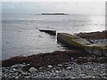
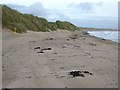
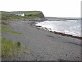
Nearby Images from Geograph Britain and Ireland:
©2011(licence)
©2008(licence)
©2008(licence)
©2008(licence)
The above images may not be of the site on this page, they are loaded from Geograph.
Please Submit an Image of this site or go out and take one for us!
Click here to see more info for this site
Nearby sites
Click here to view sites on an interactive map of the areaKey: Red: member's photo, Blue: 3rd party photo, Yellow: other image, Green: no photo - please go there and take one, Grey: site destroyed
Download sites to:
KML (Google Earth)
GPX (GPS waypoints)
CSV (Garmin/Navman)
CSV (Excel)
To unlock full downloads you need to sign up as a Contributory Member. Otherwise downloads are limited to 50 sites.
Turn off the page maps and other distractions
Nearby sites listing. In the following links * = Image available
7.5km SE 133° Saint Patrick's Chair (Coney Island)* Natural Stone / Erratic / Other Natural Feature (G61353951)
9.7km SSE 147° Sligo Airport* Chambered Tomb (G61073641)
12.0km SE 146° Knocknarea-North* Passage Grave (G62613470)
12.1km SE 146° Knocknarea* Passage Grave (G6260434583)
12.2km ESE 102° Drumcliff High Cross* Ancient Cross
14.4km SW 216° Rathurlisk Ring Fort* Hillfort
14.8km SE 134° Carrowmore 11 Stone Circle (G6646334277)
14.9km SE 134° Carrowmore 9* Stone Circle (G6650234156)
15.0km SE 136° Carrowmore 7* Passage Grave (G6633933877)
15.0km SE 136° Carrowmore 1.* Passage Grave (G6616033692)
15.0km SE 136° Carrowmore 2.* Passage Grave (G6617433701)
15.0km SE 136° Carrowmore 5.* Passage Grave (G6625233768)
15.0km SE 136° Carrowmore 4.* Passage Grave (G6621133727)
15.0km SE 137° Carrowmore 55* Passage Grave
15.1km SE 137° Carrowmore* Passage Grave (G66183365)
15.1km SE 137° Carrowmore 53* Chambered Tomb (G6611433542)
15.1km SE 136° Carrowmore 13* Burial Chamber or Dolmen
15.1km SE 137° Carrowmore 54* Passage Grave (G6615433556)
15.1km SE 137° Carrowmore 52a* Passage Grave (G6610833507)
15.1km SE 136° Carrowmore Well* Holy Well or Sacred Spring
15.1km SE 137° Carrowmore 52* Passage Grave (G6613833502)
15.2km SE 136° Carrowmore 58* Passage Grave (G6632833605)
15.2km SE 136° Carrowmore Cairn 15* Passage Grave
15.2km SE 137° Carrowmore 56* Passage Grave (G6626033537)
15.2km SE 136° Carrowmore 59* Burial Chamber or Dolmen (G6634333614)
View more nearby sites and additional images


 We would like to know more about this location. Please feel free to add a brief description and any relevant information in your own language.
 Wir möchten mehr über diese Stätte erfahren. Bitte zögern Sie nicht, eine kurze Beschreibung und relevante Informationen in Deutsch hinzuzufügen.
 Nous aimerions en savoir encore un peu sur les lieux. S'il vous plaît n'hesitez pas à ajouter une courte description et tous les renseignements pertinents dans votre propre langue.
 Quisieramos informarnos un poco más de las lugares. No dude en añadir una breve descripción y otros datos relevantes en su propio idioma.