<< Our Photo Pages >> Stalldon Row - Stone Row / Alignment in England in Devon
Submitted by thecaptain on Friday, 01 November 2024 Page Views: 23638
Neolithic and Bronze AgeSite Name: Stalldon Row Alternative Name: The Cornwood Maidens, Stalldown RowCountry: England County: Devon Type: Stone Row / Alignment
Nearest Town: Ivybridge Nearest Village: Cornwood
Map Ref: SX63236248 Landranger Map Number: 202
Latitude: 50.446179N Longitude: 3.927661W
Condition:
| 5 | Perfect |
| 4 | Almost Perfect |
| 3 | Reasonable but with some damage |
| 2 | Ruined but still recognisable as an ancient site |
| 1 | Pretty much destroyed, possibly visible as crop marks |
| 0 | No data. |
| -1 | Completely destroyed |
| 5 | Superb |
| 4 | Good |
| 3 | Ordinary |
| 2 | Not Good |
| 1 | Awful |
| 0 | No data. |
| 5 | Can be driven to, probably with disabled access |
| 4 | Short walk on a footpath |
| 3 | Requiring a bit more of a walk |
| 2 | A long walk |
| 1 | In the middle of nowhere, a nightmare to find |
| 0 | No data. |
| 5 | co-ordinates taken by GPS or official recorded co-ordinates |
| 4 | co-ordinates scaled from a detailed map |
| 3 | co-ordinates scaled from a bad map |
| 2 | co-ordinates of the nearest village |
| 1 | co-ordinates of the nearest town |
| 0 | no data |
Internal Links:
External Links:
I have visited· I would like to visit
whese001 Martin_L jimstone Murphs PAB would like to visit
Catrinm visited on 2nd Nov 2024 - their rating: Cond: 4 Amb: 5 Access: 3 A reminder this site is spectacular even as this time in the mist. Huge stones for moor. not a sould there ( via Burford row) and back
Catrinm visited on 19th Nov 2022 - their rating: Cond: 3 Amb: 5 Access: 2
Catrinm visited on 30th Mar 2019 - their rating: Cond: 4 Amb: 5 Access: 2 A nlog walk but worth it after a number of aborted trip ( sewage work gates being shut etc)
graemefield visited on 2nd Feb 2018 - their rating: Cond: 4 Amb: 5 Access: 2
markj99 visited on 1st Dec 2017 - their rating: Cond: 3 Amb: 5 Access: 3 There are two main difficulties in visiting Stalldown Row and its associated cairns:
1. Navigating the maze of narrow roads to Stall Moor.
2. Finding a safe place to park up safely close to Stall Moor
Once you have completed these two tasks the walk to Stalldown Stone Row is a picnic.
SandyG visited on 6th Apr 2013 - their rating: Cond: 4 Amb: 5 Access: 3 When visited in 2013 car parking was available at SX 62524 61120. Recently (2016) this car parking area has been closed making it much more difficult to access this part of the moor. The alternative car parking location is at SX 64342 59548. From here the easiest way to reach the row is probably to head north alongside the River Erme which will need to be crossed at some point. A decent map and reliable GPS will be essential.
Bladup TheCaptain cazzyjane have visited here
Average ratings for this site from all visit loggers: Condition: 3.67 Ambience: 5 Access: 2.5
")
The northern end of the row (SX637607) has 4 wonderful large (2 metres plus) stones still standing, with a further two large slabs fallen at the northern end, one of which was possibly a large side set slab forming a blocking stone. These four large stones can be seen from miles away all over the southern moor, and look in many ways like four walkers on the hilltop. The rest of the row consists of stones mostly just about a metre high, but some are quite a bit more. There’s a horse skull placed on top of one of the stones when I visited, which really sets it off nicely.
The row is not very straight, nor is the spacing of the stones very regular, and indeed looks to be perhaps two rows meeting at a circular cairn structure, of diameter 5 metres, and including two large pillars, just to the south of the hilltop. The northern part of the row aligns to the centre of the cairn circle, while the row to the south passes besides the western side of this cairn, before running off down the steep hillside to the south.
The lower part of the row seems to terminate at a large side set slab (SX637602) but it is possible that the original row continued for several hundred more metres to a cairn, and several buried slabs are to be found which may once have been part of the row.
Quite how much of today’s standing row is original is open to debate, as the whole structure underwent a “restoration” in about 1897, so it is possible that the misalignment of the two parts is not an original feature, and that the original structure was a much more straight and evenly spaced row.
Apart from the circular cairn beside the row near the top of the hill, there are several other cairns around and about on the hill here, one or two of which can still be seen to have their central cists in place.
This stone row is fantastic. It moves up into the top 5 stone rows I know, and perhaps my favourite stone row on Dartmoor. It is not only a tremendous row of big stones marching over the top of the hill, but sat by the central circular cairn, the views are superb. To the north, the wild moorland stretches off into the distance, while to the south, way below, are all the patchwork of fields of south Devon and then the beautiful blue sea. Plymouth sound, with its ships can clearly be seen to the south west.
Magnificent.
Update November 2019: This alignment is featured on the Stone Rows of Great Britain website - see their entry for Stalldown, which includes a description, a plan of the row and its associated cairns, photographs of the alignment and some of its individual stones and cairns, access information and a list of online resources for more information.
The SRoGB also includes an additional page to discuss and illustrate the Sea Views at Stalldown.
Prehistoric Dartmoor Walks (PDW) also features a page for this row - see their entries for the Stalldown Stone Row and the Stalldown Stone Row and Terminal Cairn.
The row is also recorded as Pastscape Monument No. 442211, as MDV4277 (Stone Row on Stalldown, Cornwood) on the Devon and Dartmoor HER, and scheduled as Historic England List Entry No. 1015806 (Stone alignment and cairns on Stalldown).
Note: Site visit report and lots of pictures of this most magnificent stone row, on southern Dartmoor. Perhaps the best stone row in the land.
You may be viewing yesterday's version of this page. To see the most up to date information please register for a free account.
")
")
")
")
")
")
")
")
")
")
")
")
")
")
")
")
")
")
")
")
")
")
")
")
These are just the first 25 photos of Stalldon Row. If you log in with a free user account you will be able to see our entire collection.
Do not use the above information on other web sites or publications without permission of the contributor.
Click here to see more info for this site
Nearby sites
Key: Red: member's photo, Blue: 3rd party photo, Yellow: other image, Green: no photo - please go there and take one, Grey: site destroyed
Download sites to:
KML (Google Earth)
GPX (GPS waypoints)
CSV (Garmin/Navman)
CSV (Excel)
To unlock full downloads you need to sign up as a Contributory Member. Otherwise downloads are limited to 50 sites.
![]()
![]()
![]()
![]()
Turn off the page maps and other distractions
Nearby sites listing. In the following links * = Image available
24m WNW 291° Stalldown Encircled Cairn* Cairn (SX6320862489)
58m ESE 120° Stalldown Stone Row Cairn E* Cairn (SX63286245)
71m S 170° Stalldown Cairn Circle* Stone Circle (SX63246241)
341m ESE 120° Stalldown Ring Cairn Circle* Ring Cairn (SX63526230)
421m WSW 245° Stalldown West* Cist (SX6284462309)
473m ESE 114° Hillson's House* Cairn (SX63666228)
620m S 179° Stalldown Stone Row Cairn S* Cairn (SX63226186)
745m S 183° Stalldown Southern Terminal Cairn Circle* Cairn (SX6317661737)
751m N 2° Stalldown North* Cairn (SX63276323)
799m W 280° Harrowthorn* Cairn (SX6244662645)
1.2km ENE 76° Three Barrows West prehistoric settlement* Ancient Village or Settlement (SX6436762738)
1.2km NNW 328° Ranny Brookhead Cist* Cist (SX62616354)
1.3km SE 143° Stalldown Settlement* Ancient Village or Settlement (SX6397361429)
1.3km NNE 29° Dry Lake North Settlement* Ancient Village or Settlement (SX639636)
1.4km NNE 13° Blatchford Brook Foot Settlement* Ancient Village or Settlement (SX63566380)
1.4km NW 319° Ranny Brook Enclosure Ancient Village or Settlement (SX6232963551)
1.5km SSE 158° Stalldown South East* Stone Row / Alignment (SX63756107)
1.5km NW 313° Ranny Brook North Cist* Cist (SX62156355)
1.6km NW 308° Yealm Steps* Ancient Village or Settlement (SX62016348)
1.7km W 279° Dendles Waste* Cairn (SX61536279)
1.9km SSE 164° Burford Down Standing Stone* Standing Stone (Menhir) (SX6370360687)
1.9km ESE 107° Sharp Tor North East* Stone Row / Alignment (SX65006188)
1.9km ESE 110° Sharp Tor cairn* Cairn (SX65006179)
2.0km N 7° Stall Moor circle* Stone Circle (SX6351764442)
2.0km N 7° Upper Erme Row* Stone Row / Alignment (SX63526447)
View more nearby sites and additional images


 We would like to know more about this location. Please feel free to add a brief description and any relevant information in your own language.
 Wir möchten mehr über diese Stätte erfahren. Bitte zögern Sie nicht, eine kurze Beschreibung und relevante Informationen in Deutsch hinzuzufügen.
 Nous aimerions en savoir encore un peu sur les lieux. S'il vous plaît n'hesitez pas à ajouter une courte description et tous les renseignements pertinents dans votre propre langue.
 Quisieramos informarnos un poco más de las lugares. No dude en añadir una breve descripción y otros datos relevantes en su propio idioma.
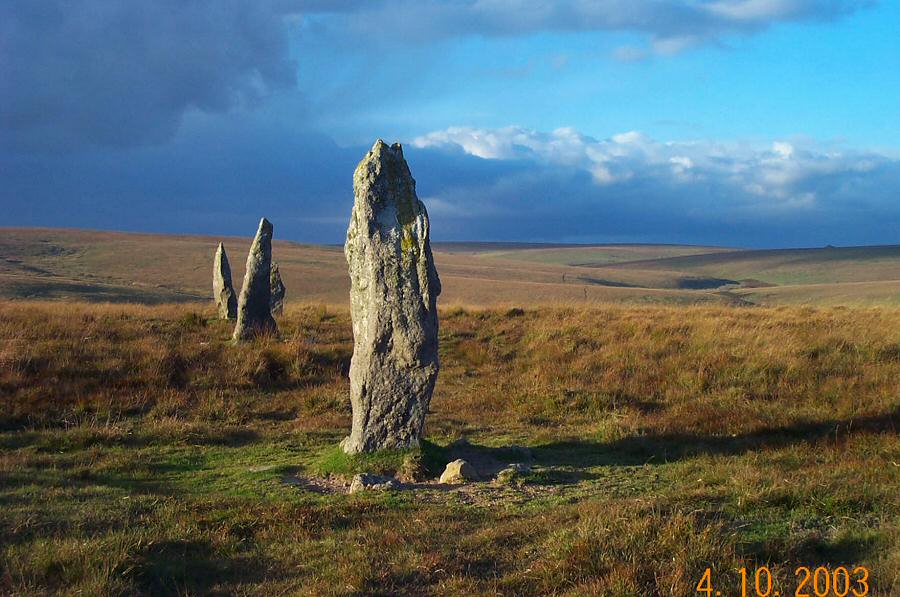