

<< Our Photo Pages >> Menhir de l'Espérelle 3 - Standing Stone (Menhir) in France in Languedoc:Hérault (34)
Submitted by LaDragonne on Thursday, 07 February 2019 Page Views: 533
Neolithic and Bronze AgeSite Name: Menhir de l'Espérelle 3Country: France Département: Languedoc:Hérault (34) Type: Standing Stone (Menhir)
Nearest Town: Lodève Nearest Village: Sorbs
Latitude: 43.875970N Longitude: 3.429480E
Condition:
| 5 | Perfect |
| 4 | Almost Perfect |
| 3 | Reasonable but with some damage |
| 2 | Ruined but still recognisable as an ancient site |
| 1 | Pretty much destroyed, possibly visible as crop marks |
| 0 | No data. |
| -1 | Completely destroyed |
| 5 | Superb |
| 4 | Good |
| 3 | Ordinary |
| 2 | Not Good |
| 1 | Awful |
| 0 | No data. |
| 5 | Can be driven to, probably with disabled access |
| 4 | Short walk on a footpath |
| 3 | Requiring a bit more of a walk |
| 2 | A long walk |
| 1 | In the middle of nowhere, a nightmare to find |
| 0 | No data. |
| 5 | co-ordinates taken by GPS or official recorded co-ordinates |
| 4 | co-ordinates scaled from a detailed map |
| 3 | co-ordinates scaled from a bad map |
| 2 | co-ordinates of the nearest village |
| 1 | co-ordinates of the nearest town |
| 0 | no data |
Internal Links:
External Links:
")
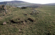
Menhir de plaine d'environ 1m50, en calcaire local, abattu non loin de son point d'érection. 2 courants.
You may be viewing yesterday's version of this page. To see the most up to date information please register for a free account.
Do not use the above information on other web sites or publications without permission of the contributor.
Nearby Images from Flickr


The above images may not be of the site on this page, but were taken nearby. They are loaded from Flickr so please click on them for image credits.
Click here to see more info for this site
Nearby sites
Click here to view sites on an interactive map of the areaKey: Red: member's photo, Blue: 3rd party photo, Yellow: other image, Green: no photo - please go there and take one, Grey: site destroyed
Download sites to:
KML (Google Earth)
GPX (GPS waypoints)
CSV (Garmin/Navman)
CSV (Excel)
To unlock full downloads you need to sign up as a Contributory Member. Otherwise downloads are limited to 50 sites.
Turn off the page maps and other distractions
Nearby sites listing. In the following links * = Image available
136m E 86° Menhir de l'Espérelle 4* Standing Stone (Menhir)
166m NW 322° Menhir de l'Espérelle 2* Standing Stone (Menhir)
452m E 86° Menhir des Baumes 3* Standing Stone (Menhir)
492m SW 229° Menhir Pas de Pertus 3* Standing Stone (Menhir)
509m SW 234° Menhir Pas de Pertus 1* Standing Stone (Menhir)
550m NNE 27° Menhir de Serre Pelé* Standing Stone (Menhir)
550m WSW 236° Menhir Pas de Pertus 2* Standing Stone (Menhir)
750m SW 232° Menhir Pas de Pertus 4* Standing Stone (Menhir)
754m NW 319° Dolmen de Latude 1* Burial Chamber or Dolmen
787m E 85° Ciste 1 Les Baumes* Cist
790m NW 323° Menhir de l'Espérelle 1* Standing Stone (Menhir)
800m SSW 197° Menhir des Gamboules* Standing Stone (Menhir)
864m NNE 30° Ciste de Serre Pelé* Cist
865m WSW 242° Tumulus Pas de Pertus 4* Round Barrow(s)
870m WSW 241° Tumulus Pas de Pertus 5 Round Barrow(s)
890m WSW 242° Tumulus Pas de Pertus 3* Round Barrow(s)
895m WSW 240° Tumulus Pas de Pertus 2* Round Barrow(s)
900m WSW 239° Menhir du Pas de Pertus* Standing Stone (Menhir)
905m WSW 238° Tumulus Pas de Pertus 1* Round Barrow(s)
945m E 92° Ciste 2 Les Baumes* Cist
996m W 277° Dolmen de Latude 2* Burial Chamber or Dolmen
1.0km W 279° Menhir de Latude 2a* Standing Stone (Menhir)
1.0km W 280° Menhir de Latude 2* Standing Stone (Menhir)
1.2km WNW 293° Menhir de Latude 1* Standing Stones
1.3km SE 135° Tumulus des Baumes* Round Barrow(s)
View more nearby sites and additional images


 We would like to know more about this location. Please feel free to add a brief description and any relevant information in your own language.
 Wir möchten mehr über diese Stätte erfahren. Bitte zögern Sie nicht, eine kurze Beschreibung und relevante Informationen in Deutsch hinzuzufügen.
 Nous aimerions en savoir encore un peu sur les lieux. S'il vous plaît n'hesitez pas à ajouter une courte description et tous les renseignements pertinents dans votre propre langue.
 Quisieramos informarnos un poco más de las lugares. No dude en añadir una breve descripción y otros datos relevantes en su propio idioma.