<< Our Photo Pages >> Robin Hoods Settlement - Ancient Village or Settlement in England in Derbyshire
Submitted by Bladup on Saturday, 06 January 2018 Page Views: 2509
Multi-periodSite Name: Robin Hoods SettlementCountry: England County: Derbyshire Type: Ancient Village or Settlement
Map Ref: SK22576238
Latitude: 53.158075N Longitude: 1.663919W
Condition:
| 5 | Perfect |
| 4 | Almost Perfect |
| 3 | Reasonable but with some damage |
| 2 | Ruined but still recognisable as an ancient site |
| 1 | Pretty much destroyed, possibly visible as crop marks |
| 0 | No data. |
| -1 | Completely destroyed |
| 5 | Superb |
| 4 | Good |
| 3 | Ordinary |
| 2 | Not Good |
| 1 | Awful |
| 0 | No data. |
| 5 | Can be driven to, probably with disabled access |
| 4 | Short walk on a footpath |
| 3 | Requiring a bit more of a walk |
| 2 | A long walk |
| 1 | In the middle of nowhere, a nightmare to find |
| 0 | No data. |
| 5 | co-ordinates taken by GPS or official recorded co-ordinates |
| 4 | co-ordinates scaled from a detailed map |
| 3 | co-ordinates scaled from a bad map |
| 2 | co-ordinates of the nearest village |
| 1 | co-ordinates of the nearest town |
| 0 | no data |
Internal Links:
External Links:
I have visited· I would like to visit
rvbaker2003 visited on 24th Dec 2024 - their rating: Cond: 2 Amb: 3 Access: 3 Very recognisable man-made activity when seen in person.
elad13 visited on 30th May 2020 - their rating: Cond: 3 Amb: 3 Access: 4
Average ratings for this site from all visit loggers: Condition: 2.5 Ambience: 3 Access: 3.5
")
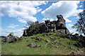
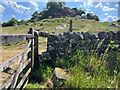
A roughly circular Bronze age enclosure comprising a 5m wide rock cut ditch surrounding an area of 0.25 hectares. The Circular bank and ditch is approx. 80.0m. diameter. Boulders enclosed by the ditch form an additional natural boundary and a number of building platforms have been identified within the enclosure, A natural rock outcrop is partly incorporated in its construction. It's easy to see from above on Google Earth or flash Earth.
You may be viewing yesterday's version of this page. To see the most up to date information please register for a free account.
")
")
")
Do not use the above information on other web sites or publications without permission of the contributor.
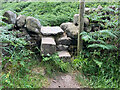
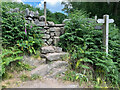
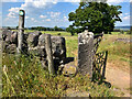
Nearby Images from Geograph Britain and Ireland:
©2005(licence)
©2023(licence)
©2023(licence)
©2023(licence)
©2023(licence)
The above images may not be of the site on this page, they are loaded from Geograph.
Please Submit an Image of this site or go out and take one for us!
Click here to see more info for this site
Nearby sites
Key: Red: member's photo, Blue: 3rd party photo, Yellow: other image, Green: no photo - please go there and take one, Grey: site destroyed
Download sites to:
KML (Google Earth)
GPX (GPS waypoints)
CSV (Garmin/Navman)
CSV (Excel)
To unlock full downloads you need to sign up as a Contributory Member. Otherwise downloads are limited to 50 sites.
Turn off the page maps and other distractions
Nearby sites listing. In the following links * = Image available
73m WNW 286° Robin Hood's Stride* Rock Outcrop (SK225624)
152m ESE 122° Cratcliff Rocks* Hillfort (SK227623)
164m SW 218° Robin Hood's Stride* Rock Art (SK22476225)
265m N 353° Nine Stones Close* Stone Circle (SK2253762643)
416m SSW 204° Dudwood* Stone Circle (SK224620)
461m N 357° Nine Stones Cup Mark (Harthill) Rock Art (SK22546284)
480m N 358° Harthill Cairn* Cairn (SK22556286)
629m NW 312° Castle Ring (Derbyshire)* Hillfort (SK221628)
721m ESE 116° Rockingstone Farm* Rock Outcrop (SK2322062065)
1.0km ESE 104° Rowtor Rocks* Rock Art (SK23556215)
1.0km ESE 106° St Michael’s Church (Birchover)* Carving (SK23576210)
1.1km ESE 106° The Megalithic Portal Live in the Derbyshire Peak District Natural Stone / Erratic / Other Natural Feature (SK236621)
1.3km ENE 69° Doll Tor* Stone Circle (SK2383062873)
1.6km ENE 67° Andle Stone (Stanton Moor)* Natural Stone / Erratic / Other Natural Feature (SK2403162993)
1.8km ENE 76° Stanton Moor Cairn T14* Cairn (SK24306281)
1.8km ENE 74° Stanton Moor Cairn T13* Round Cairn (SK243629)
1.8km ENE 77° Cork Stone* Natural Stone / Erratic / Other Natural Feature (SK2434662788)
2.1km E 79° Stanton Moor Cairn (TBC)* Cairn (SK2467562791)
2.2km ENE 74° Stanton Moor Cairn T25* Cairn (SK24656297)
2.2km ENE 77° Stanton Moor 4* Ring Cairn (SK24716290)
2.4km ENE 72° Stanton Moor Cairn T55* Round Cairn (SK24826313)
2.4km ENE 69° Stanton Moor 3* Stone Circle (SK24806326)
2.4km NW 326° All Saints Church (Youlgreave)* Carving (SK21206437)
2.4km ENE 67° Stanton Moor Cairn T24* Cairn (SK24806333)
2.5km W 275° Larks Low Bowl Barrow* Round Barrow(s) (SK20086260)
View more nearby sites and additional images


 We would like to know more about this location. Please feel free to add a brief description and any relevant information in your own language.
 Wir möchten mehr über diese Stätte erfahren. Bitte zögern Sie nicht, eine kurze Beschreibung und relevante Informationen in Deutsch hinzuzufügen.
 Nous aimerions en savoir encore un peu sur les lieux. S'il vous plaît n'hesitez pas à ajouter une courte description et tous les renseignements pertinents dans votre propre langue.
 Quisieramos informarnos un poco más de las lugares. No dude en añadir una breve descripción y otros datos relevantes en su propio idioma.