

<< Text Pages >> Dolmen de la Forêt de Molac 2 - Burial Chamber or Dolmen in France in Bretagne:Morbihan (56)
Submitted by holger_rix on Thursday, 11 February 2016 Page Views: 561
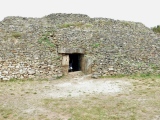
Neolithic and Bronze AgeSite Name: Dolmen de la Forêt de Molac 2Country: France Département: Bretagne:Morbihan (56) Type: Burial Chamber or Dolmen
Nearest Town: Vannes Nearest Village: Le Cours
Latitude: 47.762420N Longitude: 2.531919W
Condition:
| 5 | Perfect |
| 4 | Almost Perfect |
| 3 | Reasonable but with some damage |
| 2 | Ruined but still recognisable as an ancient site |
| 1 | Pretty much destroyed, possibly visible as crop marks |
| 0 | No data. |
| -1 | Completely destroyed |
| 5 | Superb |
| 4 | Good |
| 3 | Ordinary |
| 2 | Not Good |
| 1 | Awful |
| 0 | No data. |
| 5 | Can be driven to, probably with disabled access |
| 4 | Short walk on a footpath |
| 3 | Requiring a bit more of a walk |
| 2 | A long walk |
| 1 | In the middle of nowhere, a nightmare to find |
| 0 | No data. |
| 5 | co-ordinates taken by GPS or official recorded co-ordinates |
| 4 | co-ordinates scaled from a detailed map |
| 3 | co-ordinates scaled from a bad map |
| 2 | co-ordinates of the nearest village |
| 1 | co-ordinates of the nearest town |
| 0 | no data |
Be the first person to rate this site - see the 'Contribute!' box in the right hand menu.
Internal Links:
External Links:
Burial Chamber (Dolmen) in Bretagne:Morbihan (56)
Le Cours, Vannes, Morbihan, Brittany
Source: T4T35.fr
You may be viewing yesterday's version of this page. To see the most up to date information please register for a free account.
Do not use the above information on other web sites or publications without permission of the contributor.
Click here to see more info for this site
Nearby sites
Click here to view sites on an interactive map of the areaKey: Red: member's photo, Blue: 3rd party photo, Yellow: other image, Green: no photo - please go there and take one, Grey: site destroyed
Download sites to:
KML (Google Earth)
GPX (GPS waypoints)
CSV (Garmin/Navman)
CSV (Excel)
To unlock full downloads you need to sign up as a Contributory Member. Otherwise downloads are limited to 50 sites.
Turn off the page maps and other distractions
Nearby sites listing. In the following links * = Image available
226m S 189° Menhir de la Forêt de Molac 3 Standing Stone (Menhir)
250m NNE 33° Menhir de la Forêt de Molac 1 Standing Stone (Menhir)
250m ENE 63° Allée Couverte de la Forêt de Molac Passage Grave
255m S 188° Menhir de la Forêt de Molac 4 Standing Stone (Menhir)
257m SSE 163° Dolmen de la Forêt de Molac 3 Burial Chamber or Dolmen
387m NE 47° Dolmen de la Forêt de Molac 1 Burial Chamber or Dolmen
596m N 5° Menhir de la Forêt de Molac 2 Standing Stone (Menhir)
752m N 351° Dolmen de Coëby 1* Burial Chamber or Dolmen
770m NW 316° Dolmen de Coëby 4 Burial Chamber or Dolmen
820m NW 315° Dolmen de Coëby 3 Burial Chamber or Dolmen
989m WNW 284° Dolmen de Coëby 2* Burial Chamber or Dolmen
1.1km NW 324° Dolmen de Coëby 5 Burial Chamber or Dolmen
1.1km WNW 283° Menhirs de Coëby 1* Standing Stones
1.1km ESE 107° Dolmen du Batiment de la Foret Burial Chamber or Dolmen
1.2km ESE 114° Dolmen de la Maison de la Forêt Burial Chamber or Dolmen
1.4km NE 38° Allée couvert Les Bellans* Passage Grave
1.4km ENE 63° Menhir de La Noë Standing Stone (Menhir)
1.6km WSW 256° Allée Couverte de Coëby Passage Grave
1.6km N 359° Menhirs de Belle Alouette* Standing Stones
1.8km WNW 290° Pont Plan* Standing Stone (Menhir)
1.9km NNE 14° Le Passoir Menhir* Standing Stone (Menhir)
1.9km NW 305° Pierre Tabulaire de la Bataille* Burial Chamber or Dolmen
1.9km W 265° Menhir de Ker-Antoine Standing Stone (Menhir)
2.0km NNW 341° Grand Breuil Menhir* Standing Stone (Menhir)
2.2km SSE 159° Menhir de Clos Bono* Standing Stone (Menhir)
View more nearby sites and additional images


 We would like to know more about this location. Please feel free to add a brief description and any relevant information in your own language.
 Wir möchten mehr über diese Stätte erfahren. Bitte zögern Sie nicht, eine kurze Beschreibung und relevante Informationen in Deutsch hinzuzufügen.
 Nous aimerions en savoir encore un peu sur les lieux. S'il vous plaît n'hesitez pas à ajouter une courte description et tous les renseignements pertinents dans votre propre langue.
 Quisieramos informarnos un poco más de las lugares. No dude en añadir una breve descripción y otros datos relevantes en su propio idioma.