<< Text Pages >> Allée Couverte de Bois-Meur - Passage Grave in France in Bretagne:Côtes-D'Armor (22)
Submitted by holger_rix on Monday, 11 January 2016 Page Views: 984
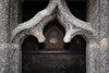
Neolithic and Bronze AgeSite Name: Allée Couverte de Bois-MeurCountry: France Département: Bretagne:Côtes-D'Armor (22) Type: Passage Grave
Nearest Town: Guingamp Nearest Village: Lanrodec
Latitude: 48.480330N Longitude: 3.06669W
Condition:
| 5 | Perfect |
| 4 | Almost Perfect |
| 3 | Reasonable but with some damage |
| 2 | Ruined but still recognisable as an ancient site |
| 1 | Pretty much destroyed, possibly visible as crop marks |
| 0 | No data. |
| -1 | Completely destroyed |
| 5 | Superb |
| 4 | Good |
| 3 | Ordinary |
| 2 | Not Good |
| 1 | Awful |
| 0 | No data. |
| 5 | Can be driven to, probably with disabled access |
| 4 | Short walk on a footpath |
| 3 | Requiring a bit more of a walk |
| 2 | A long walk |
| 1 | In the middle of nowhere, a nightmare to find |
| 0 | No data. |
| 5 | co-ordinates taken by GPS or official recorded co-ordinates |
| 4 | co-ordinates scaled from a detailed map |
| 3 | co-ordinates scaled from a bad map |
| 2 | co-ordinates of the nearest village |
| 1 | co-ordinates of the nearest town |
| 0 | no data |
Be the first person to rate this site - see the 'Contribute!' box in the right hand menu.
Internal Links:
External Links:
Passage Grave in Bretagne:Côtes-D'Armor (22)
Lanrodec, Guingamp, Côtes-d'Armor, Brittany
Source: T4T35.fr
You may be viewing yesterday's version of this page. To see the most up to date information please register for a free account.
Do not use the above information on other web sites or publications without permission of the contributor.
Nearby Images from Flickr

The above images may not be of the site on this page, but were taken nearby. They are loaded from Flickr so please click on them for image credits.
Click here to see more info for this site
Nearby sites
Click here to view sites on an interactive map of the areaKey: Red: member's photo, Blue: 3rd party photo, Yellow: other image, Green: no photo - please go there and take one, Grey: site destroyed
Download sites to:
KML (Google Earth)
GPX (GPS waypoints)
CSV (Garmin/Navman)
CSV (Excel)
To unlock full downloads you need to sign up as a Contributory Member. Otherwise downloads are limited to 50 sites.
Turn off the page maps and other distractions
Nearby sites listing. In the following links * = Image available
5.9km WSW 251° Stèle dite Ar Villien Sculptured Stone
6.3km S 190° Menhir de Kerprat Standing Stone (Menhir)
6.6km WSW 247° Tanouëdou tumulus* Round Barrow(s)
6.9km ESE 116° Kergoff* Standing Stone (Menhir)
7.0km WSW 246° Restes (Bourbriac) allée couverte Passage Grave
7.3km SSE 161° Allée couverte du Parc-Kerdic* Passage Grave
7.6km SSE 166° Menhir de Coldabry Standing Stone (Menhir)
8.0km NE 39° Stèle dit Le Lech* Sculptured Stone
8.3km S 181° Coat Ar Belleques* Standing Stone (Menhir)
8.3km S 172° Menhir de La Villeneuve* Standing Stone (Menhir)
8.7km WNW 285° Dolmen de Kervoaic Burial Chamber or Dolmen
8.8km NNW 348° Stèles Gauloises du Boulbin* Standing Stones
8.8km SW 225° Caillouan Menhir* Standing Stone (Menhir)
9.0km SSE 156° Vieux Bourg Tumulus Chambered Tomb
9.0km E 95° Pré de Camet Standing Stones
9.2km SSE 156° Menhir de Keranhouët* Standing Stone (Menhir)
9.4km SSE 155° Botudo menhirs* Standing Stones
9.4km SW 231° Menhir de Toul-du* Standing Stone (Menhir)
9.5km SW 217° Dolmen de Keranquéré* Burial Chamber or Dolmen
9.8km S 172° Pasquiou menhir* Standing Stone (Menhir)
10.2km S 172° Dolmen de Pasquiou* Burial Chamber or Dolmen
10.2km SSW 199° Lesquiolec Standing Stone (Menhir)
10.6km S 174° La Croix du Pasquiou* Standing Stone (Menhir)
10.6km S 175° Cre'h Ogel menhir* Standing Stone (Menhir)
10.6km SSE 167° Porzic menhir* Standing Stone (Menhir)
View more nearby sites and additional images


 We would like to know more about this location. Please feel free to add a brief description and any relevant information in your own language.
 Wir möchten mehr über diese Stätte erfahren. Bitte zögern Sie nicht, eine kurze Beschreibung und relevante Informationen in Deutsch hinzuzufügen.
 Nous aimerions en savoir encore un peu sur les lieux. S'il vous plaît n'hesitez pas à ajouter une courte description et tous les renseignements pertinents dans votre propre langue.
 Quisieramos informarnos un poco más de las lugares. No dude en añadir una breve descripción y otros datos relevantes en su propio idioma.