
, Aubrey Burl")
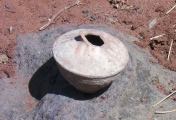
<< Our Photo Pages >> Vale de Rodrigo 2 - Burial Chamber or Dolmen in Portugal in Évora
Submitted by Bak_teria on Monday, 14 December 2015 Page Views: 2915
Neolithic and Bronze AgeSite Name: Vale de Rodrigo 2Country: Portugal Distrito: Évora Type: Burial Chamber or Dolmen
Nearest Town: Évora Nearest Village: Nossa Senhora da Tourega
Latitude: 38.495583N Longitude: 8.059774W
Condition:
| 5 | Perfect |
| 4 | Almost Perfect |
| 3 | Reasonable but with some damage |
| 2 | Ruined but still recognisable as an ancient site |
| 1 | Pretty much destroyed, possibly visible as crop marks |
| 0 | No data. |
| -1 | Completely destroyed |
| 5 | Superb |
| 4 | Good |
| 3 | Ordinary |
| 2 | Not Good |
| 1 | Awful |
| 0 | No data. |
| 5 | Can be driven to, probably with disabled access |
| 4 | Short walk on a footpath |
| 3 | Requiring a bit more of a walk |
| 2 | A long walk |
| 1 | In the middle of nowhere, a nightmare to find |
| 0 | No data. |
| 5 | co-ordinates taken by GPS or official recorded co-ordinates |
| 4 | co-ordinates scaled from a detailed map |
| 3 | co-ordinates scaled from a bad map |
| 2 | co-ordinates of the nearest village |
| 1 | co-ordinates of the nearest town |
| 0 | no data |
Internal Links:
External Links:
I have visited· I would like to visit
Bak_teria has visited here
")
For further Info check out also:
Conjunto Megalítico de Vale de Rodrigo
Other valuable information
CNS: 622
Aditional information:
- You are entering in private property but the access is possible.
- The entrance to the zone of the monuments may be blocked by fences, they were essentially made to demarcate the land and not allow the escape of livestock. Usually there are spaces in the fences within these demarcated areas where the access is possible. When entering in demarcated land never forget to close the access gate of the location, you need to be very aware because cattle can escape.
- There are no signs prohibiting us from entering so the access can be open but be careful when you explore every time you see this red plaques that alert you for the Hunting Zones. Remind yourself that usually hunters can only hunt at selected hunting days (Thursdays, Sundays and on public holidays).
You may be viewing yesterday's version of this page. To see the most up to date information please register for a free account.
")
")
")
")
Do not use the above information on other web sites or publications without permission of the contributor.
Nearby Images from Flickr
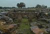
The above images may not be of the site on this page, but were taken nearby. They are loaded from Flickr so please click on them for image credits.
Click here to see more info for this site
Nearby sites
Click here to view sites on an interactive map of the areaKey: Red: member's photo, Blue: 3rd party photo, Yellow: other image, Green: no photo - please go there and take one, Grey: site destroyed
Download sites to:
KML (Google Earth)
GPX (GPS waypoints)
CSV (Garmin/Navman)
CSV (Excel)
To unlock full downloads you need to sign up as a Contributory Member. Otherwise downloads are limited to 50 sites.
Turn off the page maps and other distractions
Nearby sites listing. In the following links * = Image available
827m NNW 341° Vale de Rodrigo 3* Burial Chamber or Dolmen
1.5km NW 322° Conjunto Megalítico de Vale de Rodrigo* Barrow Cemetery
1.7km NNW 332° Vale de Rodrigo 1* Round Barrow(s)
2.8km ENE 76° Villa de Nossa Senhora de Tourega* Ancient Village or Settlement
4.6km NW 324° Anta Da Rocha 2 Burial Chamber or Dolmen
4.9km ENE 72° Anta do Barrocal 2* Burial Chamber or Dolmen
4.9km ENE 74° Anta Herdade do Barrocal 1* Burial Chamber or Dolmen
5.0km NW 312° Marco Miliário de São Brissos* Marker Stone
5.1km NW 319° Anta Da Rocha 1 Burial Chamber or Dolmen
5.2km NNE 27° Castelo do Giraldo* Castro or Chafurdão
6.0km NE 43° Miliário da Mitra (Valverde)* Marker Stone
6.0km N 3° Menir no Vale dos Cardos Standing Stone (Menhir)
6.2km NE 36° Anta Pequena do Zambujeiro* Burial Chamber or Dolmen
6.3km NE 39° Anta Grande do Zambujeiro* Burial Chamber or Dolmen
6.9km WNW 298° Anta-Capela de Nossa Senhora do Livramento* Burial Chamber or Dolmen
6.9km N 359° Cromeleque dos Almendres* Stone Circle
7.7km N 7° Menir dos Almendres* Standing Stone (Menhir)
8.1km NW 309° Tholos do Escoural* Burial Chamber or Dolmen
8.5km NNE 19° Centro Interpretativo dos Almendres* Museum
8.6km NW 308° Gruta do Escoural* Cave or Rock Shelter
8.9km WNW 300° Anta da Carvoeira* Burial Chamber or Dolmen
9.7km NNW 339° Menir da Giesteira Standing Stone (Menhir)
10.5km E 101° Anta da Herdade do Zambujal Burial Chamber or Dolmen
11.3km NE 52° Menir 2 das Lajes* Standing Stone (Menhir)
11.4km N 350° Anta do Pinheiro 2* Burial Chamber or Dolmen
View more nearby sites and additional images


 We would like to know more about this location. Please feel free to add a brief description and any relevant information in your own language.
 Wir möchten mehr über diese Stätte erfahren. Bitte zögern Sie nicht, eine kurze Beschreibung und relevante Informationen in Deutsch hinzuzufügen.
 Nous aimerions en savoir encore un peu sur les lieux. S'il vous plaît n'hesitez pas à ajouter une courte description et tous les renseignements pertinents dans votre propre langue.
 Quisieramos informarnos un poco más de las lugares. No dude en añadir una breve descripción y otros datos relevantes en su propio idioma.