


<< Our Photo Pages >> Southdean Law - Hillfort in Scotland in Scottish Borders
Submitted by h_fenton on Saturday, 25 June 2011 Page Views: 4275
Iron Age and Later PrehistorySite Name: Southdean LawCountry: Scotland County: Scottish Borders Type: Hillfort
Nearest Town: Jedburgh Nearest Village: Chesters
Map Ref: NT63500938
Latitude: 55.377034N Longitude: 2.577543W
Condition:
| 5 | Perfect |
| 4 | Almost Perfect |
| 3 | Reasonable but with some damage |
| 2 | Ruined but still recognisable as an ancient site |
| 1 | Pretty much destroyed, possibly visible as crop marks |
| 0 | No data. |
| -1 | Completely destroyed |
| 5 | Superb |
| 4 | Good |
| 3 | Ordinary |
| 2 | Not Good |
| 1 | Awful |
| 0 | No data. |
| 5 | Can be driven to, probably with disabled access |
| 4 | Short walk on a footpath |
| 3 | Requiring a bit more of a walk |
| 2 | A long walk |
| 1 | In the middle of nowhere, a nightmare to find |
| 0 | No data. |
| 5 | co-ordinates taken by GPS or official recorded co-ordinates |
| 4 | co-ordinates scaled from a detailed map |
| 3 | co-ordinates scaled from a bad map |
| 2 | co-ordinates of the nearest village |
| 1 | co-ordinates of the nearest town |
| 0 | no data |
Internal Links:
External Links:
I have visited· I would like to visit
h_fenton has visited here
")
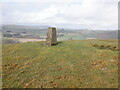
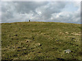
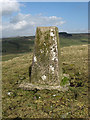
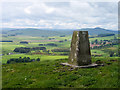
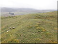
Southdean Law, the earliest remains are a bivallate Early Iron Age fort (50x32m) to which an annex was added later. On the north-east side the fort is partially overlaid by a settlement of eleven houses with some associated enclosures, it has been assumed that these houses date to around 2nd-4thCenturyAD. The fort is located on the western end of a ridge that is Southdean Law.
The fort is surrounded by rig cultivation, and there are a couple of possible cairns/ burial mounds (not recorded by RCAHMS) on the ridge outside of the fort.
Access/Parking: if approaching on the A6088 from Chesters, you pass Southdean on your right, next you pass a quarry on your left, just beyond the quarry (150m) there is space on the verge (NT 6365 0907) on the left to park without blocking the field entrances. Then head up the hill with the quarry on your left.
see: canmore.rcahms.gov.uk/en/site/56826/details/southdean+law
You may be viewing yesterday's version of this page. To see the most up to date information please register for a free account.
")
")
Do not use the above information on other web sites or publications without permission of the contributor.
Nearby Images from Geograph Britain and Ireland:
©2023(licence)
©2008(licence)
©2008(licence)
©2017(licence)
©2023(licence)
The above images may not be of the site on this page, they are loaded from Geograph.
Please Submit an Image of this site or go out and take one for us!
Click here to see more info for this site
Nearby sites
Key: Red: member's photo, Blue: 3rd party photo, Yellow: other image, Green: no photo - please go there and take one, Grey: site destroyed
Download sites to:
KML (Google Earth)
GPX (GPS waypoints)
CSV (Garmin/Navman)
CSV (Excel)
To unlock full downloads you need to sign up as a Contributory Member. Otherwise downloads are limited to 50 sites.
Turn off the page maps and other distractions
Nearby sites listing. In the following links * = Image available
3.8km E 88° Shaw Craigs Hillfort (NT67270945)
5.4km NE 55° Edgerston Hillfort (NT67981245)
6.0km E 82° Knock Hill Cairn Cairn (NT69451016)
7.2km N 1° Gilliestongues Promontory Fort / Cliff Castle (NT63721659)
7.2km WNW 292° Hawthornside Farm (Bonchester Bridge)* Holy Well or Sacred Spring (NT5678612089)
7.3km ESE 117° Elsdon Stone Circle Stone Circle (NT700060)
8.2km NW 318° Rubers Law* Hillfort (NT58031557)
8.7km ENE 76° Moor Head (Brundean Laws)* Standing Stones (NT7193111439)
8.9km S 178° The Kielder Stone* Natural Stone / Erratic / Other Natural Feature (NT63690050)
9.3km NNW 337° Bedrule Parish Church* Sculptured Stone (NT5992217925)
9.4km NNW 335° Bedrule Sculptured Stone (NT59501793)
9.7km NNW 335° Fast Castle (Bedrule)* Misc. Earthwork (NT59531822)
10.0km W 260° Stonedge Stone Circle (NT536077)
10.5km ENE 65° Dark Wood* Cairn (NT73111377)
11.1km N 8° Jedburgh Ancient Christian Stones* Ancient Cross (NT65052038)
11.1km N 8° Jedburgh Rock Art Rock Art (NT651204)
11.3km WNW 303° Cavers Cross* Ancient Cross (NT54071564)
12.1km E 86° Upper Hindhope* Standing Stones (NT75641008)
12.2km SSW 205° Caddrounburn Calvert* Ancient Village or Settlement (NY58199836)
12.4km ENE 64° Falla Knowe Cairn* Cairn (NT74711475)
13.1km ENE 61° Dere Street Cairn* Round Cairn (NT75061552)
13.1km NW 309° Midshiels Standing Stone* Standing Stone (Menhir) (NT53391774)
13.1km NW 309° Midshiels Cairn* Cairn (NT53311770)
13.1km ENE 62° Black Knowe (Borders)* Standing Stone (Menhir) (NT75131554)
13.2km ENE 60° Five Stanes B Stone Circle (NT7516)
View more nearby sites and additional images


 We would like to know more about this location. Please feel free to add a brief description and any relevant information in your own language.
 Wir möchten mehr über diese Stätte erfahren. Bitte zögern Sie nicht, eine kurze Beschreibung und relevante Informationen in Deutsch hinzuzufügen.
 Nous aimerions en savoir encore un peu sur les lieux. S'il vous plaît n'hesitez pas à ajouter une courte description et tous les renseignements pertinents dans votre propre langue.
 Quisieramos informarnos un poco más de las lugares. No dude en añadir una breve descripción y otros datos relevantes en su propio idioma.