

<< Text Pages >> Tusari Protonuraghe - Broch or Nuraghe in Italy in Sardinia (Sardegna)
Submitted by SolarMegalith on Wednesday, 02 February 2011 Page Views: 3048
Neolithic and Bronze AgeSite Name: Tusari ProtonuragheCountry: Italy Region: Sardinia (Sardegna) Type: Broch or Nuraghe
Nearest Town: Macomer Nearest Village: Silanus
Latitude: 40.267350N Longitude: 8.873000E
Condition:
| 5 | Perfect |
| 4 | Almost Perfect |
| 3 | Reasonable but with some damage |
| 2 | Ruined but still recognisable as an ancient site |
| 1 | Pretty much destroyed, possibly visible as crop marks |
| 0 | No data. |
| -1 | Completely destroyed |
| 5 | Superb |
| 4 | Good |
| 3 | Ordinary |
| 2 | Not Good |
| 1 | Awful |
| 0 | No data. |
| 5 | Can be driven to, probably with disabled access |
| 4 | Short walk on a footpath |
| 3 | Requiring a bit more of a walk |
| 2 | A long walk |
| 1 | In the middle of nowhere, a nightmare to find |
| 0 | No data. |
| 5 | co-ordinates taken by GPS or official recorded co-ordinates |
| 4 | co-ordinates scaled from a detailed map |
| 3 | co-ordinates scaled from a bad map |
| 2 | co-ordinates of the nearest village |
| 1 | co-ordinates of the nearest town |
| 0 | no data |
Internal Links:
External Links:
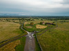
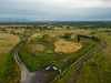
Protonuraghe in Sardinia (Sardegna)
Remains of a corridor-style Bronze Age nuraghe preserved in distinguishable shape.
You may be viewing yesterday's version of this page. To see the most up to date information please register for a free account.
Do not use the above information on other web sites or publications without permission of the contributor.
Nearby Images from Flickr

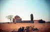
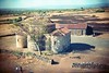
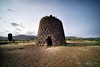
The above images may not be of the site on this page, but were taken nearby. They are loaded from Flickr so please click on them for image credits.
Click here to see more info for this site
Nearby sites
Click here to view sites on an interactive map of the areaKey: Red: member's photo, Blue: 3rd party photo, Yellow: other image, Green: no photo - please go there and take one, Grey: site destroyed
Download sites to:
KML (Google Earth)
GPX (GPS waypoints)
CSV (Garmin/Navman)
CSV (Excel)
To unlock full downloads you need to sign up as a Contributory Member. Otherwise downloads are limited to 50 sites.
Turn off the page maps and other distractions
Nearby sites listing. In the following links * = Image available
790m NE 48° Ortu Nuraghe (Silanus)* Broch or Nuraghe
1.2km NE 45° Santa Sabina Nuraghe* Broch or Nuraghe
1.4km ENE 57° Santa Sabina Tomba di Giganti B* Chambered Tomb
1.4km NE 54° Santa Sabina Tomba di Giganti A* Chambered Tomb
1.9km N 353° Ordari Domus de Janas Rock Cut Tomb
1.9km N 355° Ordari Nuraghe Broch or Nuraghe
2.0km NW 314° Berre Protonuraghe* Broch or Nuraghe
2.4km SSW 200° Ponte Nuraghe* Broch or Nuraghe
2.5km SSE 156° Cubas Protonuraghe Broch or Nuraghe
2.6km SSW 200° Frenugarzu Protonuraghe* Broch or Nuraghe
2.8km WNW 301° Teriani Tomba di Giganti* Chambered Tomb
2.9km NNE 25° Betili di Silanus* Standing Stones
2.9km WNW 302° Teriani Nuraghe* Broch or Nuraghe
3.4km NE 38° Madrone Nuraghe* Broch or Nuraghe
3.6km WNW 291° Sa Corte Nuraghe* Broch or Nuraghe
4.0km W 271° Miuddu Nuraghe* Broch or Nuraghe
4.0km SSE 161° Lughe Dolmen Burial Chamber or Dolmen
4.1km SSE 159° Sos Coloros Recinto Nuragico Ancient Village or Settlement
4.3km SW 214° Arbu Protonuraghe* Broch or Nuraghe
4.4km SW 224° Cobercada Domus de Janas* Rock Cut Tomb
4.4km SW 217° Arbu 2 Dolmen* Burial Chamber or Dolmen
4.4km SW 217° Arbu 1 Dolmen* Burial Chamber or Dolmen
4.5km WNW 290° Tintirriolos Insediamento Nuragico* Ancient Village or Settlement
4.5km WNW 291° Tintirriolos Nuraghe* Broch or Nuraghe
4.6km ESE 123° S'Ulivera Protonuraghe Broch or Nuraghe
View more nearby sites and additional images


 We would like to know more about this location. Please feel free to add a brief description and any relevant information in your own language.
 Wir möchten mehr über diese Stätte erfahren. Bitte zögern Sie nicht, eine kurze Beschreibung und relevante Informationen in Deutsch hinzuzufügen.
 Nous aimerions en savoir encore un peu sur les lieux. S'il vous plaît n'hesitez pas à ajouter une courte description et tous les renseignements pertinents dans votre propre langue.
 Quisieramos informarnos un poco más de las lugares. No dude en añadir una breve descripción y otros datos relevantes en su propio idioma.