

<< Our Photo Pages >> Arbu 2 Dolmen - Burial Chamber or Dolmen in Italy in Sardinia (Sardegna)
Submitted by SolarMegalith on Tuesday, 12 December 2017 Page Views: 939
Neolithic and Bronze AgeSite Name: Arbu 2 Dolmen Alternative Name: Dolmen Arbu IICountry: Italy Region: Sardinia (Sardegna) Type: Burial Chamber or Dolmen
Nearest Town: Birori
Latitude: 40.236238N Longitude: 8.841773E
Condition:
| 5 | Perfect |
| 4 | Almost Perfect |
| 3 | Reasonable but with some damage |
| 2 | Ruined but still recognisable as an ancient site |
| 1 | Pretty much destroyed, possibly visible as crop marks |
| 0 | No data. |
| -1 | Completely destroyed |
| 5 | Superb |
| 4 | Good |
| 3 | Ordinary |
| 2 | Not Good |
| 1 | Awful |
| 0 | No data. |
| 5 | Can be driven to, probably with disabled access |
| 4 | Short walk on a footpath |
| 3 | Requiring a bit more of a walk |
| 2 | A long walk |
| 1 | In the middle of nowhere, a nightmare to find |
| 0 | No data. |
| 5 | co-ordinates taken by GPS or official recorded co-ordinates |
| 4 | co-ordinates scaled from a detailed map |
| 3 | co-ordinates scaled from a bad map |
| 2 | co-ordinates of the nearest village |
| 1 | co-ordinates of the nearest town |
| 0 | no data |
Internal Links:
External Links:
I have visited· I would like to visit
SolarMegalith visited on 6th Sep 2017 - their rating: Cond: 4 Amb: 4 Access: 4
")
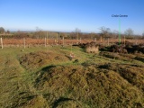
Dolmen Arbu 2 is located just few meters North-West of its twin brother. It consists of two natural rocks and a capstone of 1.70 x 1.22 x 0.45m dimensions which covers space between them.
Moravetti, A. 1998. Ricerche archeologiche nel Marghine-Planargia. Il Marghine: monumenti: parte prima. Sassari: Carlo Delfino Editore (p. 355).
You may be viewing yesterday's version of this page. To see the most up to date information please register for a free account.
")
Do not use the above information on other web sites or publications without permission of the contributor.
Nearby Images from Flickr


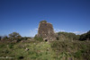

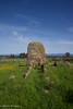

The above images may not be of the site on this page, but were taken nearby. They are loaded from Flickr so please click on them for image credits.
Click here to see more info for this site
Nearby sites
Click here to view sites on an interactive map of the areaKey: Red: member's photo, Blue: 3rd party photo, Yellow: other image, Green: no photo - please go there and take one, Grey: site destroyed
Download sites to:
KML (Google Earth)
GPX (GPS waypoints)
CSV (Garmin/Navman)
CSV (Excel)
To unlock full downloads you need to sign up as a Contributory Member. Otherwise downloads are limited to 50 sites.
Turn off the page maps and other distractions
Nearby sites listing. In the following links * = Image available
20m SSE 164° Arbu 1 Dolmen* Burial Chamber or Dolmen
259m ESE 121° Arbu Protonuraghe* Broch or Nuraghe
508m NW 311° Cobercada Domus de Janas* Rock Cut Tomb
1.4km SSW 204° Porcarzos Nuraghe* Broch or Nuraghe
2.0km ENE 60° Frenugarzu Protonuraghe* Broch or Nuraghe
2.1km SSW 202° Santu Bainzu Tomba di Giganti* Chambered Tomb
2.2km ENE 58° Ponte Nuraghe* Broch or Nuraghe
2.2km SSW 199° Toscono Nuraghe* Broch or Nuraghe
2.3km WNW 286° Sorolo Nuraghe* Broch or Nuraghe
2.6km WNW 301° Sarbogadas Ponte Nuragico* Ancient Trackway
2.6km WNW 301° Sas Bogadas Ponte Nuragico Ancient Trackway
2.6km WNW 300° Sarbogadas Dolmen* Burial Chamber or Dolmen
2.9km SW 230° Bighinzone Nuraghe* Broch or Nuraghe
3.1km SW 236° Urpes Nuraghe Broch or Nuraghe
3.3km WSW 239° Duos Nuraghes Complesso Nuragico* Ancient Village or Settlement
3.4km NW 317° Lassia Tomba di Giganti* Chambered Tomb
3.6km W 278° Bau Cannas Domus de Janas* Rock Cut Tomb
3.7km NNW 339° Miuddu Nuraghe* Broch or Nuraghe
3.9km ENE 72° Cubas Protonuraghe Broch or Nuraghe
3.9km NW 324° Nurattolu Recinto Nuragico* Broch or Nuraghe
4.0km E 94° Lughe Dolmen Burial Chamber or Dolmen
4.1km E 95° Sos Coloros Recinto Nuragico Ancient Village or Settlement
4.2km NW 326° Palatu Tomba di Giganti* Chambered Tomb
4.2km SW 222° Imbertighe Nuraghe* Broch or Nuraghe
4.3km NW 323° Chessa Nuraghe* Broch or Nuraghe
View more nearby sites and additional images


 We would like to know more about this location. Please feel free to add a brief description and any relevant information in your own language.
 Wir möchten mehr über diese Stätte erfahren. Bitte zögern Sie nicht, eine kurze Beschreibung und relevante Informationen in Deutsch hinzuzufügen.
 Nous aimerions en savoir encore un peu sur les lieux. S'il vous plaît n'hesitez pas à ajouter une courte description et tous les renseignements pertinents dans votre propre langue.
 Quisieramos informarnos un poco más de las lugares. No dude en añadir una breve descripción y otros datos relevantes en su propio idioma.