

<< Our Photo Pages >> St Baglan's Church (Llanfaglan) - Early Christian Sculptured Stone in Wales in Gwynedd
Submitted by Sunny100 on Saturday, 14 August 2010 Page Views: 14651
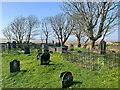
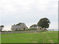
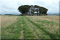
Early Medieval (Dark Age)Site Name: St Baglan's Church (Llanfaglan) Alternative Name: The Lovernus Stone, St Baglan's StoneCountry: Wales County: Gwynedd Type: Early Christian Sculptured Stone
Nearest Town: Caernarfon Nearest Village: Llanfaglan
Map Ref: SH4550660714
Latitude: 53.121153N Longitude: 4.310116W
Condition:
| 5 | Perfect |
| 4 | Almost Perfect |
| 3 | Reasonable but with some damage |
| 2 | Ruined but still recognisable as an ancient site |
| 1 | Pretty much destroyed, possibly visible as crop marks |
| 0 | No data. |
| -1 | Completely destroyed |
| 5 | Superb |
| 4 | Good |
| 3 | Ordinary |
| 2 | Not Good |
| 1 | Awful |
| 0 | No data. |
| 5 | Can be driven to, probably with disabled access |
| 4 | Short walk on a footpath |
| 3 | Requiring a bit more of a walk |
| 2 | A long walk |
| 1 | In the middle of nowhere, a nightmare to find |
| 0 | No data. |
| 5 | co-ordinates taken by GPS or official recorded co-ordinates |
| 4 | co-ordinates scaled from a detailed map |
| 3 | co-ordinates scaled from a bad map |
| 2 | co-ordinates of the nearest village |
| 1 | co-ordinates of the nearest town |
| 0 | no data |
Internal Links:
External Links:
I have visited· I would like to visit
PAB has visited here
 (PID:88331)")
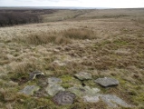
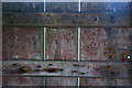
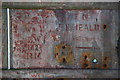
Apparently the stones were dug-up in the locality and brought into the church for safety. Embedded into the wall near the porch are two grave-slabs bearing large incised Celtic crosses, one is built into the windowsill and the other acts as a lintel. On one there is a Romano-British inscription recalling LOVER NUS FILI or LAVER NUS FILI - 'here lies Lovernus', dating from the 5th century. The Lintel stone and a third stone most likely date from the 10th century, though there is some uncertainty about this.
The church is dedicated to St Baglan the son of Dingad. He lived sometime in the 6th-7th century and was an abbot of Bardsey Island. In a field a few hundred yards to the NE of the church lies Ffynnon Faglan (St Baglan's Holy Well) which was referred to as a 'pin well' - bent pins were thrown into the water in the hope of a miracle of healing.
The pillar stone reused as a lintel is recorded as Coflein NPRN 95765. This entry concludes with the sentence: "Cropmarks of an involved enclosure complex have been recorded about the church" - see (NPRN 403370). For more information about the church see Coflein NPRN 43690.
The Journal of Antiquities also includes an entry for this site - scroll down their page for Some Inscribed Stones in Wales.
You may be viewing yesterday's version of this page. To see the most up to date information please register for a free account.
 (PID:88332)")
 (PID:88330)")
Do not use the above information on other web sites or publications without permission of the contributor.
PAB has found this location on Google Street View:
Nearby Images from Geograph Britain and Ireland:
©2022(licence)
©2006(licence)
©2019(licence)
©2007(licence)
©2007(licence)
The above images may not be of the site on this page, they are loaded from Geograph.
Please Submit an Image of this site or go out and take one for us!
Click here to see more info for this site
Nearby sites
Key: Red: member's photo, Blue: 3rd party photo, Yellow: other image, Green: no photo - please go there and take one, Grey: site destroyed
Download sites to:
KML (Google Earth)
GPX (GPS waypoints)
CSV (Garmin/Navman)
CSV (Excel)
To unlock full downloads you need to sign up as a Contributory Member. Otherwise downloads are limited to 50 sites.
Turn off the page maps and other distractions
Nearby sites listing. In the following links * = Image available
520m ENE 73° Ffynnon Faglan* Holy Well or Sacred Spring (SH46016085)
3.1km SSE 162° Dinas y Prif Camp* Ancient Village or Settlement (SH4633957760)
3.1km ENE 59° St Helen's Well (Coed Helen) Holy Well or Sacred Spring (SH4823862224)
3.5km ENE 59° Segontium* Stone Fort or Dun (SH4852262408)
4.0km NE 43° Modern Standing Stones (Caernarfon)* Modern Stone Circle etc (SH4833363592)
4.1km NE 42° Modern Stone Circle (Caernarfon)* Modern Stone Circle etc (SH4835463629)
4.8km SSW 200° Dinas Dinlle* Hillfort (SH437563)
5.1km S 175° Glynllifon Monolith Standing Stone (Menhir) (SH4577055574)
5.2km ESE 116° Gaerwen Ancient Village or Settlement (SH501583)
5.4km S 185° Ffynnon Adliw Holy Well or Sacred Spring (SH4490155385)
5.5km SSW 192° Bodfan Standing Stone* Standing Stone (Menhir) (SH4420555327)
6.1km NW 310° Crochan Llanddwyn* Holy Well or Sacred Spring (SH40986478)
6.3km N 5° Bryn Gwyn Stones* Stone Circle (SH4623566927)
6.4km N 7° Castell Bryn-Gwyn* Henge (SH4652867061)
6.5km ENE 75° Cilgwythwch Maenhir* Standing Stone (Menhir) (SH51866217)
6.5km NNE 20° Perthiduon* Chambered Tomb (SH4798066758)
6.5km S 182° Plas Newydd Ancient Village or Settlement (SH4507954192)
6.6km N 357° Maesoglan 3* Standing Stone (Menhir) (SH454673)
6.6km N 356° Maesoglan 2* Standing Stone (Menhir) (SH453673)
6.6km S 187° Maen Llwyd (Gwynedd)* Standing Stone (Menhir) (SH4449554155)
6.7km N 356° Maesoglan 1* Standing Stone (Menhir) (SH452674)
6.7km N 9° Tre'r Dryw Bach W Stone Circle (SH468673)
6.8km S 179° Penbryn Mawr Standing Stone* Standing Stone (Menhir) (SH4537253927)
6.9km SSE 151° Cae Forgan Cairn* Cairn (SH487546)
6.9km SSE 148° Cae Forgan Standing Stone* Standing Stone (Menhir) (SH490547)
View more nearby sites and additional images


 We would like to know more about this location. Please feel free to add a brief description and any relevant information in your own language.
 Wir möchten mehr über diese Stätte erfahren. Bitte zögern Sie nicht, eine kurze Beschreibung und relevante Informationen in Deutsch hinzuzufügen.
 Nous aimerions en savoir encore un peu sur les lieux. S'il vous plaît n'hesitez pas à ajouter une courte description et tous les renseignements pertinents dans votre propre langue.
 Quisieramos informarnos un poco más de las lugares. No dude en añadir una breve descripción y otros datos relevantes en su propio idioma.