<< Our Photo Pages >> Lower Dunn - Broch or Nuraghe in Scotland in Caithness
Submitted by cosmic on Saturday, 13 October 2007 Page Views: 3302
Iron Age and Later PrehistorySite Name: Lower DunnCountry: Scotland County: Caithness Type: Broch or Nuraghe
Nearest Town: Wick
Map Ref: ND2026656718
Latitude: 58.491339N Longitude: 3.369438W
Condition:
| 5 | Perfect |
| 4 | Almost Perfect |
| 3 | Reasonable but with some damage |
| 2 | Ruined but still recognisable as an ancient site |
| 1 | Pretty much destroyed, possibly visible as crop marks |
| 0 | No data. |
| -1 | Completely destroyed |
| 5 | Superb |
| 4 | Good |
| 3 | Ordinary |
| 2 | Not Good |
| 1 | Awful |
| 0 | No data. |
| 5 | Can be driven to, probably with disabled access |
| 4 | Short walk on a footpath |
| 3 | Requiring a bit more of a walk |
| 2 | A long walk |
| 1 | In the middle of nowhere, a nightmare to find |
| 0 | No data. |
| 5 | co-ordinates taken by GPS or official recorded co-ordinates |
| 4 | co-ordinates scaled from a detailed map |
| 3 | co-ordinates scaled from a bad map |
| 2 | co-ordinates of the nearest village |
| 1 | co-ordinates of the nearest town |
| 0 | no data |
Internal Links:
External Links:
")
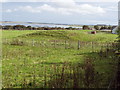
Remains of a broch just off the A882
You may be viewing yesterday's version of this page. To see the most up to date information please register for a free account.
Do not use the above information on other web sites or publications without permission of the contributor.
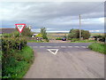
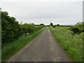
Nearby Images from Geograph Britain and Ireland:
©2008(licence)
©2007(licence)
©2022(licence)

©2021(licence)
©2008(licence)
The above images may not be of the site on this page, they are loaded from Geograph.
Please Submit an Image of this site or go out and take one for us!
Click here to see more info for this site
Nearby sites
Key: Red: member's photo, Blue: 3rd party photo, Yellow: other image, Green: no photo - please go there and take one, Grey: site destroyed
Download sites to:
KML (Google Earth)
GPX (GPS waypoints)
CSV (Garmin/Navman)
CSV (Excel)
To unlock full downloads you need to sign up as a Contributory Member. Otherwise downloads are limited to 50 sites.
Turn off the page maps and other distractions
Nearby sites listing. In the following links * = Image available
242m NNE 22° Lower Dunn (2) Broch or Nuraghe (ND2036356940)
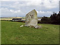
390m SSE 151° Bridge of Dunn Standing Stone* Standing Stone (Menhir) (ND2045156374)
604m SSE 165° Bridge of Dunn Broch Broch or Nuraghe (ND20415613)
2.4km E 87° Lynegar House, Oslie Cairn* Chambered Cairn (ND22715679)
2.8km E 91° Lynegar House, Grey Cairn* Broch or Nuraghe (ND23045662)
3.6km SW 228° Spittal Farm Broch or Nuraghe (ND17565438)
4.0km SE 143° Cairn of Achoy Broch or Nuraghe (ND22605348)
4.1km SW 229° Spittal Quarry* Modern Stone Circle etc (ND171541)
4.2km E 101° Loch Watten Crannog* Crannog (ND24435585)
4.3km SW 217° Knockglass Broch Broch or Nuraghe (ND17615329)
4.7km SE 125° Nether Banks* Broch or Nuraghe (ND24105397)
4.8km ESE 118° Watten Standing Stone* Standing Stone (Menhir) (ND24445436)
4.9km E 97° Tulach Gorm (Mains of Watten) Broch or Nuraghe (ND25105604)
5.2km SE 127° Achingale Broch or Nuraghe (ND24345353)
5.2km NW 320° Mill of Knockdee* Chambered Cairn (ND17036077)
5.2km SE 146° Carn A' Chladha* Broch or Nuraghe (ND23135233)
5.2km NW 310° Torran Reitheach Cairn (ND1629160143)
5.3km NNE 20° The Stone Lud* Standing Stone (Menhir) (ND222617)
5.4km E 86° Scottag* Broch or Nuraghe (ND25665699)
5.5km SSE 157° Acharole* Stone Circle (ND22335166)
5.6km SSE 152° Bail of A' Chairn* Broch or Nuraghe (ND22815171)
5.7km NNE 25° Mains of Bowertower Broch or Nuraghe (ND22796179)
5.7km NE 38° Halcro Manse* Broch or Nuraghe (ND23896119)
5.9km WSW 254° Achanarras Hill* Stone Circle (ND14545525)
6.2km SSW 213° Achkeepster Broch or Nuraghe (ND16805158)
View more nearby sites and additional images


 We would like to know more about this location. Please feel free to add a brief description and any relevant information in your own language.
 Wir möchten mehr über diese Stätte erfahren. Bitte zögern Sie nicht, eine kurze Beschreibung und relevante Informationen in Deutsch hinzuzufügen.
 Nous aimerions en savoir encore un peu sur les lieux. S'il vous plaît n'hesitez pas à ajouter une courte description et tous les renseignements pertinents dans votre propre langue.
 Quisieramos informarnos un poco más de las lugares. No dude en añadir una breve descripción y otros datos relevantes en su propio idioma.