

<< Our Photo Pages >> Menires na Herdade dos Perdigões - Stone Circle in Portugal in Évora
Submitted by AlexHunger on Tuesday, 30 May 2006 Page Views: 8416
Neolithic and Bronze AgeSite Name: Menires na Herdade dos Perdigões Alternative Name: Cromeleque dos PerdigõesCountry: Portugal Distrito: Évora Type: Stone Circle
Nearest Town: Reguengos de Monsaraz
Latitude: 38.440046N Longitude: 7.543943W
Condition:
| 5 | Perfect |
| 4 | Almost Perfect |
| 3 | Reasonable but with some damage |
| 2 | Ruined but still recognisable as an ancient site |
| 1 | Pretty much destroyed, possibly visible as crop marks |
| 0 | No data. |
| -1 | Completely destroyed |
| 5 | Superb |
| 4 | Good |
| 3 | Ordinary |
| 2 | Not Good |
| 1 | Awful |
| 0 | No data. |
| 5 | Can be driven to, probably with disabled access |
| 4 | Short walk on a footpath |
| 3 | Requiring a bit more of a walk |
| 2 | A long walk |
| 1 | In the middle of nowhere, a nightmare to find |
| 0 | No data. |
| 5 | co-ordinates taken by GPS or official recorded co-ordinates |
| 4 | co-ordinates scaled from a detailed map |
| 3 | co-ordinates scaled from a bad map |
| 2 | co-ordinates of the nearest village |
| 1 | co-ordinates of the nearest town |
| 0 | no data |
Internal Links:
External Links:
I have visited· I would like to visit
Bak_teria visited on 23rd Apr 2016 - their rating: Cond: 2 Amb: 3 Access: 3
")
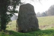
This is a group of 5 standing stones (originally 6) in very bad shape, all of them are broken but some remain in situ. One is still nailed to the ground but broken, appears to be in situ, this one with a height of 1.2 m from the current ground level. There's another one that is in the same conditions and is inclined at about 45 degrees. The larger of the group is also broken but has 2 metres long and is of a cylindrical shape. This menhir is full of dimples aligned along a longitudinal axis, probably due to the erosion phenomenon which has been exposed to over time. These whole group of stones was probably erected in the Neo-Chalcolithic period and are dispersed in an area of 2,400 m2. This monument was target of archaeological surveys made by Mário Varela Gomes in 1977 and was classified as IIP - Estate of Public Interest at the 22nd of November, 1971.
About the access
The access can be made by going from the city of Reguengos de Monsaraz, using as starting point the end of the Fountain street (Rua da Fonte) and going 780 metres through a local dirt road that goes North and gives access to agricultural lands. It's advisable to use an offroad vehicle since the road is not in the best conditions. Stop when you see a red gateway at your right side. Enter the gate and do the rest of the way by foot, it's a small walk of 350 metres from there. Remember this is private property (people do Olive oil production in this site), there are nothing prohibiting you from entering, but if you see someone always ask kindly for permission to enter and visit the property. By doing this you should have no problems.
Links and information sources (all texts written in Portuguese):
- DGPC
- Portal do Arqueólogo
Additional information:
- You are entering in private property but the access is possible.
- The entrance to the zone of the monuments may be blocked by fences, they were essentially made to demarcate the land and not allow the escape of livestock. Usually there are spaces in the fences within these demarcated areas where the access is possible. When entering in demarcated land never forget to close the access gate of the location, you need to be very aware because cattle can escape.
- There are no signs prohibiting us from entering so the access can be open but be careful when you explore every time you see this red plaques that alert you for the Hunting Zones. Remind yourself that usually hunters can only hunt at selected hunting days (Thursdays, Sundays and on public holidays).
Site originally submitted by AlexHunger. Additional info by Bak_teria.
You may be viewing yesterday's version of this page. To see the most up to date information please register for a free account.
")
")
")
")
")
")
")
")
")
Do not use the above information on other web sites or publications without permission of the contributor.
Click here to see more info for this site
Nearby sites
Click here to view sites on an interactive map of the areaKey: Red: member's photo, Blue: 3rd party photo, Yellow: other image, Green: no photo - please go there and take one, Grey: site destroyed
Download sites to:
KML (Google Earth)
GPX (GPS waypoints)
CSV (Garmin/Navman)
CSV (Excel)
To unlock full downloads you need to sign up as a Contributory Member. Otherwise downloads are limited to 50 sites.
Turn off the page maps and other distractions
Nearby sites listing. In the following links * = Image available
3.2km E 82° Cromeleque do Monte da Ribeira do Álamo* Stone Circle
5.3km SSE 146° Menir dos Gorginos* Standing Stone (Menhir)
5.5km SSE 157° Menir na Herdade das Vidigueiras* Standing Stone (Menhir)
6.0km E 84° Rocha dos Namorados* Standing Stone (Menhir)
6.5km SSE 163° Farisoa* Stone Circle
6.7km SE 129° Anta das Areias 2* Burial Chamber or Dolmen
6.7km SE 129° Anta das Areias 1* Burial Chamber or Dolmen
7.1km W 265° Anta e Menir da Igreja de São Vicente do Pigeiro* Modern Stone Circle etc
10.0km E 83° Menir de Santa Margarida* Standing Stone (Menhir)
11.3km E 89° Menir do Barrocal* Standing Stone (Menhir)
12.5km E 84° Anta 1 do Olival da Pega* Burial Chamber or Dolmen
12.7km E 84° Anta 2 do Olival da Pega* Burial Chamber or Dolmen
13.5km ENE 75° Menhir de Outeiro* Standing Stone (Menhir)
14.1km NNE 13° Pedra do Galo* Natural Stone / Erratic / Other Natural Feature
14.3km E 80° Menir da Bulhoa* Standing Stone (Menhir)
14.3km E 84° Well of Telheiro* Holy Well or Sacred Spring
14.3km E 81° Anta da Belhôa* Burial Chamber or Dolmen
15.1km E 84° Cromeleque do Xarez* Stone Circle
16.8km E 92° Praia Fluvial de Monsaraz Modern Stone Circle* Modern Stone Circle etc
17.1km S 188° Anta do Chão da Pereira* Burial Chamber or Dolmen
17.7km SE 127° Museu da Luz* Museum
18.2km W 277° Castelos de Monte Novo Castro or Chafurdão
19.4km S 172° Anta da Torrejona 1* Burial Chamber or Dolmen
19.4km S 172° Anta da Torrejona 2* Burial Chamber or Dolmen
19.6km SW 231° Castro de Castelo Velho Castro or Chafurdão
View more nearby sites and additional images


 We would like to know more about this location. Please feel free to add a brief description and any relevant information in your own language.
 Wir möchten mehr über diese Stätte erfahren. Bitte zögern Sie nicht, eine kurze Beschreibung und relevante Informationen in Deutsch hinzuzufügen.
 Nous aimerions en savoir encore un peu sur les lieux. S'il vous plaît n'hesitez pas à ajouter une courte description et tous les renseignements pertinents dans votre propre langue.
 Quisieramos informarnos un poco más de las lugares. No dude en añadir una breve descripción y otros datos relevantes en su propio idioma.